To search for any sites in the northern counties of England (previously known as Brigantia), click on the list of relevant counties, below. Please note that not all these english counties were truly in Brigantia, but they came close to its southern edges; and as parts of them tickle the edges of the southern Pennines, I thought they should be included. Hope that’s OK with everyone!
This small, simple cup-marked stone is found close to the small Mudbeck stone circle. Consisting of just four shallow cup-marks almost running in an arc formation, the site was first discovered by Tim Laurie in the late 1990s. I’ve not been to this place so rely on the photos kindly sent me by Richard Stroud, and the description of the place by Paul Brown (2008), where he told:
Close-up of 4 cups (courtesy Richard Stroud)Mudbeck 2 in the landscape (courtesy Richard Stroud)
“On the crest of a ridge some 50m south-west of Mudbeck a scatter of small boulders form an indistinct ring-shape and a cup-marked boulder with four cups was discovered here by Tim Laurie. It was suggested that the stone scatter represented the possible remains of a cairn that had at some point in its past been stripped of its stone for the construction of walling and sheepfolds in the area. ”
The only other cup-mark close by is one alleged to be on one of the small uprights in the Mudbeck circle (known as MUD S1 in Brown’s survey) – though I have to say that the “carving” is somewhat dubious to me.
References:
Brown, Paul and Barbara, Prehistoric Rock Art in the Northern Dales, Tempus: Stroud 2008.
Acknowledgements: Many thanks to Richard Stroud for use of the photos in this site profile.
Truly takes some finding this one and you’ve got those energy-depleting tribbles (tussocks) to contend with in your journey here! But if you’ve good ankles and enjoy bouncing the moors, it aint too bad. It’s 4 miles east of Tan Hill, some 700 yards west of the confluence of Mud Beck and Arkle Beck, and some 300 yards north of Arkle Beck amidst the grassy open moorland. Look around and you’ll find it!
Archaeology & History
Located on a prominent position on a ridge at the head of a pass into Upper Arkengarthdale, this site was first found in 1982 by local Shepherd William Stubbs, who informed Tim Laurie, who then contacted Archibald Thom – son of the legendary Alexander Thom – who went on to survey the site in 1983. Thom “recorded five stones in the ring, one slab buried on the line of the perimeter, and a small stone just inside the ring.” He reckoned the outlying stone 55 yards ENE was also part of the original complex. His survey found its geometry to be a perfect circle in design. And, in good old-fashioned Alex Thom fashion, measured the diameter of the circle at precisely 22.53 megalithic yards; that’s about 20 yards to you and me!
All the stones in the ring are pretty small and unassuming and the site gives more an impression of having burial associations, but I’m unaware of any such finds. There are other little known sites scattering this region and we need a few ventures scouting around to see what more can be found…
References:
Curtis, Ronald, ‘The Geometry of Some Megalithic Rings,’ in Records in Stone (edited by Clive Ruggles), Cambridge University Press 1988.
From Silsden, take the moorland road up to Brunthwaite (ask a local if you’re in doubt). As you get near the top of the moorland road, take the right turn (east) on the track past the Doubler Stones, until you reach the last cottage before the woodland called Black Pots. Go onto the moorland behind the cottage, walking north, crossing the stream and you’ll see a large boulder stuck on its own close by. That’s it!
Archaeology & History
Stuart Feather’s 1964 image
On another wander on these moors t’other day, we ventured to the Doubler Stones and whilst there I had a vague recollection of another decent-looking carving west of them, just above the hidden house at Black Pots, when I was a teenager. When I got home I rummaged through some of my old notebooks and found the drawing I made of it all those years ago. Tis a decent carving consisting of 3 distinct cups encircled, though not completely, in an elongated arc. A cup-and-ring is just above this, and Boughey & Vickerman (2003) highlight another couple of cups which I didn’t manage to see when I was there as a kid. Nor for that matter did Stuart Feather, who was the first person to write about it in the Cartwright Hall Archaeology Group Bulletin in 1964. Itis a good carving in a good spot, with excellent views to the south and west.
References:
Boughey, Keith & Vickerman, E.A., Prehistoric Rock Art of the West Riding, WYAS: Leeds 2003.
Feather, Stuart, “Mid-Wharfedale Cup-and-Ring Markings: no.24 – Black Pots, Silsden, near Keighley,” in Cartwright Hall Archaeology Group Bulletin, 9:7, 1964.
Hedges, John, The Carved Rocks on Rombald’s Moor, WYMCC: Wakefield 1986.
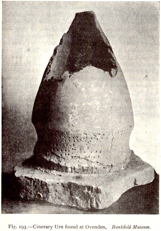
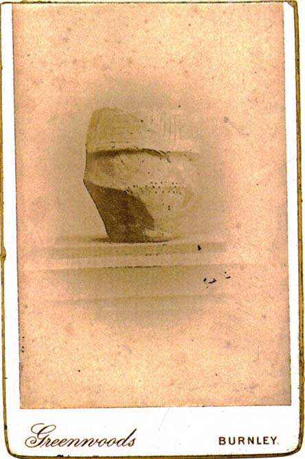
As with a number of prehistoric burials in the Halifax district, there is no longer any trace of the original site here. It was a place that I wrongly attributed as being a dolmen in my early survey on West Yorkshire’s megalithic remains (Bennett 1994) — but at least I got the prehistoric tomb part of it right! It was first found, quite accidentally, in February of 1877, when a grave-digger working in the grounds of the Mount Zion Chapel at Ovenden (as it was known in them days) hit upon a large stone beneath the earth he was digging. Thankfully the grave-digger was a conscientious chap and, instead of just digging up the obstruction, decided to inform others of his discovery. A temporary halt was made on his grave-digging and thereafter a careful dig was organized to explore what he’d found. Some years later an account of the discovery was reported in H. Ling Roth’s (1906) work on the history of Halifax, where he told:
“On digging about 2ft (61cm) below the surface of the ground, a slab of stone impeded the work, and on its removal, a square cavity, formed of four upright stones, was discovered, in which the urn had been placed bottom upwards (see old photo, PB), and the mausoleum filled with gravel… The urn had not been disturbed since its removal from its present site, but still remains on its original base: a rude stone which formed the floor of its ancient sepulchre. The urn measured when first discovered 19in (48cm) in height by 13in (32.5cm) in diameter at its orifice, but only 4in (10.2cm) at its base. Below its rim it has the usual curved division which is here ornamented with dots made with a pointed instrument when the clay was in a soft state.”
Mr Roth went on to tell how a Dr Dolan of Halifax examined the broken bones and contents within the urn and found them to be human. Intriguingly it seems there was some evidence of prehistoric dental practice from the remains! Dr Dolan told:
“There is unmistakable evidence on this point from some of the bones of the skull, particularly from the preserved portions of the petrous part of the temporal bone showing meatus auditorius, from the right malar bone, and from fragments of the flat bones of the cranium. The teeth offer confirmatory evidence. I have found several which had evidently been subjected to great heat, as they were completely calcined. But there was one which had been only partially burnt, the burnt part being quite black; and another, unburnt, which seems to have dropped from the jaw before the fire had reached it. One of the teeth seems to me to have been ‘stopped’, and this opens out a question whether the art of dentistry was known to the inhabitants before the Roman invasion. From the size and structure of the bones, I believe the majority of them to have belonged to a female of adult age. There are certain bones, particularly some phalanges, which seem to me to be those of a child. As we do not however possess the whole of the original contents of the urn — much having been extracted from it on its discovery — there may probably have been, when first interred, the relics of others than those we at present possess.”
The remains of the urn were eventually presented to the care of the Bankfield Museum by the Halifax antiquary, F.A. Leyland.
A definitive account of this little-known site was recently published by Raymond Varley (2021), and all interested readers can refer to his work here.
References:
Bennett, Paul, Circles, Standing Stones and Legendary Rocks of West Yorkshire, Heart of Albion Press: Loughborough 1994.
Leyland, F.A., The History and Antiquities of the Parish of Halifax, by the Reverend John Watson, M.A., R.Leyland: Halifax n.d. (c.1867)
Roth, H. Ling, The Yorkshire Coiners, 1767-1783; and Notes on Old and Prehistoric Halifax, F.King: Halifax 1906.
Troublesome to get to if you don’t know the area. You can get here rom Halifax, up through Highroad Well towards Wainstalls, keeping to the road that leads to the Oxenhope windmills. A short distance before the windmills, as the road levels out, keep your eye out on the right where the valley drops down (east) to the Halifax golf-course. If you’re coming from Oxenhope, walk up past the windmills at Nab End until the road starts going back downhill. As you look down and walk past the valley with the golf course in it, a footpath is on your left running diagonally over a field. Cross the stile and walk alongside the wall for about 200 yards until you reach a gate on your left. Go through this and walk along until you see the ditched earthworks that make up this little-known monument…
Archaeology & History
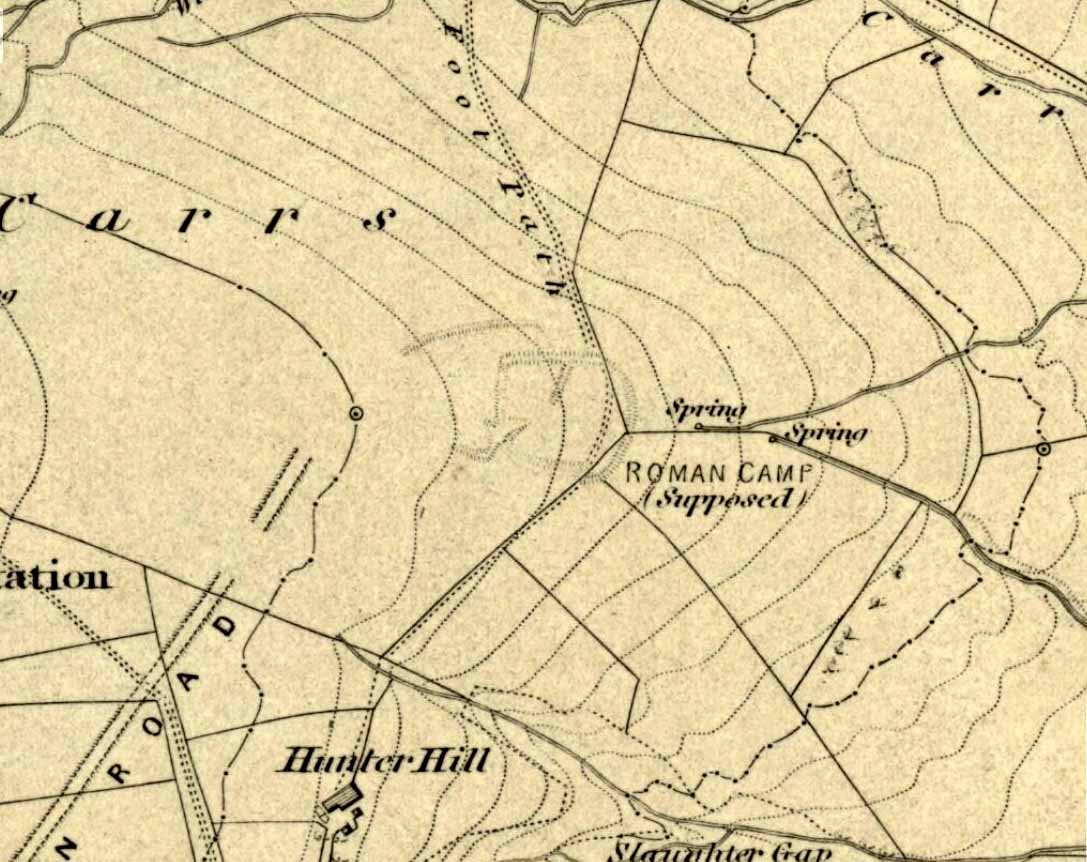
Not to be confused with the large circular enclosure that once crowned the nearby Hunter Hill, the nature and age of this large D-shaped earthwork has long been a source of speculation, with the majority of it centring around a Roman origin — and for good reason, it has to be said!
NW section of earthworksSouthern section of ditch
More than 280 yards (260m) in circumference, its north-south axis measures 82 yards (75m) at the greatest and 88 yards (81m) east-west. Its main feature is a decent ditch that averages 8-10 feet across round most of the D-shaped feature, and between 2-3 feet deep. It would obviously have been deeper than this when the ditches were first dug, but it’s now very overgrown across the entire site with Juncus grasses and tribbles (tussocks). A small internal ditch runs into the enclosure from the northern side. Its function is unknown. A small mound near the centre of the site has been posited by Calderdale archaeologists to be modern remains.
Carrs enclosure on 1852 map
Although the main feature is the D-shaped earthwork, other features are apparent. For example, what looks like another man-made dyke cutting into the site on the southwestern side is in fact a natural stream channel. This natural feature may have been an integral part of the enclosure when it was first built. Above the northwestern edge of the ditch (as can be seen on the aerial photo) are other earthworks that run around the western edge of the main feature. This is probably what F.A. Leyland (1867) meant when he described there to be “the remains of several lines of intrenchments” here. Also coming into the southwestern side are what are thought to be the remains of a Roman Road. Early OS-maps (above) show the road running within yards of this enclosure — and it was this which, logically, led many earlier researchers to posit the notion that this site was in fact Roman. However, a dig here in 1951 recovered prehistoric pottery, which knocked the date back to the Iron Age.
Northern line of ditch
On the south and east sides, parts of the ditch and embankment have been removed by quarrying and farm-workings, with the walling on the eastern side completely ruining that part of the monument. A great number of flints have been found on the hills above here. I’m unable to give a more detailed exposition on the archaeological finds at this site as I don’t have a copy of Mr Varley’s (1997) essay that he wrote for the Transactions of the Hunter Archaeological Society, which apparently gives more info. When I manage to get a copy of the journal/essay, I’ll add the relevant data to this profile.
A note must also be made of another, previously unrecognized enclosure on the same hilltop a couple of hundred yards to the west from here. Very little trace of it is still visible at ground level, but the outline of the curvaceous quadrilateral ditch form can be seen from the air. It would appear from its form to be consistent with an Iron Age enclosure, though without further research this has to be proclaimed as hypothetical. No excavations are planned here in the near future.
Folklore
In F.A. Leyland’s (1867) superb commentary to Mr Watson’s History of Halifax, he told us:
“There is a well-preserved tradition amongst the inhabitants that a battle in which numbers fell was fought at a place called the Slaughters or Slaughter Gap, in the hollow between the Carrs and Hunter-hill. Fragments of gun-barrels and locks, with human bones, have been found about the place…”
But Leyland deemed the armoury finds here — that appeared to substantiate the folklore — were from a much later period in history than the enclosure. But I must draw attention to the remarkable Mixenden Finds, as they’ve become known: a collection of finely polished prehistoric axes and other stone remains a few hundred yards below The Carrs and which may relate to such folklore.
References:
Leyland, F.A., The History and Antiquities of the Parish of Halifax, by the Reverend John Watson, M.A., R.Leyland: Halifax n.d. (c.1867)
Varley, Raymond, “The Excavation of Castle Stead at Manywells Height, near Cullingworth, West Yorkshire,” in Transactions of the Hunter Archaeological Society, volume 19, 1997.
Varley, Raymond A., “Lost Neolithic and Bronze Age Finds from Mixenden, near Halifax, West Yorkshire,” in Yorkshire Archaeological Journal 70, 1998.
Described in Walter Bennett’s (1946) magnum opus as a “stone circle” and repeated in Aubrey Burl’s (2000) magnum opus under the same category, the site here seems more likely to have been an old cairn circle, or perhaps even a simple tumulus — and a small one at that! It was first noted in June of 1842 when the antiquarian, Mr F.C. Spencer of Halifax, “had his attention called to a circle of stones in a field called Delph Hill Pasture by Jonas Lee, a Thursden farmer, and a somewhat noted character in his day” who knew the location very well. It didn’t take long for Mr Spencer to realise that this was “an ancient British barrow,” as he called it, and made plans to excavate the site soon after seeing it.
Following Spencer’s dig, a short account of the finds was made in the Gentleman’s Magazine, telling of the remains of this “small circle of stones” and the burials therein. The account said:
“The circle originally consisted of rock pillars (five of which remain) , standing about 18 inches above the surface, and being about 2 feet square. The diameter of the circle is about 5 yards. Mr Spencer directed an excavation to be made without delay, the result of which was the discovery of two very antique earthen urns, curiously marked, containing fragments of human bones, of small dimensions, mixed with charcoal and black mould. The tops of the vessels were covered with small flat slate-stones, but little larger than the urns, over which larger heavy stones were placed for their protection. The urns were found about 2 feet beneath the surface of the field, in the centre of the circle, embedded in soft clay, with many pieces of charcoal interspersed. About 300 yards from the barrow are the bold remains of a British circular camp…”
A few years later, Tattersall Wilkinson (1893) told that “three unglazed urns, with human remains and flint arrowheads” (my italics) were found at the locale. Curiously there has been some confusion as to the number of urns that were actually found at Delf Hill by different authors over the last 175 years (numbering between 1 and 3, depending on whose account you read!), but it would seem this has occurred due to the proximity of other tombs close by.
An excursion to Delf Hill a few years after Spencer’s first dig is described in an article by L. Clement (1874), where several members of a local history society reported that the mound here consisted of a “small circle of stones, seven in number, fourteen feet in diameter”, that probably surrounded the hillock. One of the stones had been knocked over and moved, so the group took it upon themselves to place the monolith back into what they thought was its original setting within the monument.
Found to the southwest edge of Hildenley Wood, on the west side of the track between Malton and Coneythorpe Road, the waters from the initial source of the well runs into a small well-house, and from here Nature’s blood runs into a small pool. The first reference I’ve found of the place is in T. Whellan’s (1859) huge survey, where he said,
“There is on the verge of Easthorpe Wood a copious and pure spring of water known by the name of Holy Well, which tradition affirms to have been much resorted to by the monks of Kirkham Abbey…and even to this day healing virtues are attributed to it.”
In Whelan & Taylor’s (1989) survey of the site, they noted the existence of another well a short distance away, but did “not know of any sacred associations connected with this site, but its proximity to the Holy Well may suggest the recognition of this area as a sacred spot.”
Tumulus (destroyed): OS Grid Reference – SE 094 242
Archaeology & History
Shaw Hill urn
The remains here have long since succumbed to that self-righteous advance of industrial civilization. Even when the Halifax historian John Watson (1775) first described what had been here, the burial mound had gone; but thankfully he was fortunate in getting details regarding the whereabouts and contents of the remains. Three burial urns were found next to each other — presumably in the same tumulus — one of which was in a reasonably good state of preservation, as shown from the illustration which I reproduce here. We have no description of the burial mound, only of the urns, of which Mr Watson told us:
“It was found, with two others, at the gates, at the bottom of the walk near Shaw Hill, leading to the house in Skircoat, called Heath. They lay in a line, one yard deep and one yard asunder, with their mouths downwards. This contained calcined bones, and dust; the two others were broken in pieces. It is eight inches deep, stands upon a bottom of four inches diameter and, where there is no moulding, is from twenty-one inches, or thereabouts, to twenty-three inches in circumference.”
It was of similar size and design to burial urns found at Tower Hill a couple of miles west of Halifax. In Prof Watson’s (1952) work on the prehistoric sites of Calderdale, he assigned this burial mound and pottery to have been from the Bronze Age.
References:
Leyland, F.A., The History and Antiquities of the Parish of Halifax, by the Reverend John Watson, M.A., R.Leyland: Halifax n.d. (c.1867)
Roth, H. Ling, The Yorkshire Coiners, 1767-1783; and Notes on Old and Prehistoric Halifax, F.King: Halifax 1906.
Watson, John, The History and Antiquities of the Parish of Halifax, T. Lowndes: London 1775.
Watson, Geoffrey G., Early Man in the Halifax District, HSS: Halifax 1952.
Stone Circle (destroyed): OS Grid Reference – SE 088 256
Archaeology & History
The place-name authority A.H. Smith (1961), in searching for the meaning behind the old region in Halifax known as “stannary”, just west of the town centre, was puzzled by its implications and found it wanting, so he took the most likely option as he saw it, writing, “probably it is a stone circle,” from the archaic verbs stan (stone) and hring (ring).
First recorded in the Halifax Court Rolls of 1575 as “Stannerying”, this implied it to be a place where tin-ware was sold in a field, “though that word belongs rather to Cornwall,” he said, and it appeared out of place at the time it was written. So he looked elsewhere. The Halifax Parish Registers of 1578 didn’t help much, describing the place as “Stanerye.” However, the Halifax Rent Records of 1588 named it as “Standeringe”, which is much closer to Smith’s idea. With each written instance we certainly find the old English stan, but the suffix in two instances is difficult to assess with firm conviction.
If we could locate additional folklore or other historical data that might throw further light on this, it would be an important find. The finding of prehistoric burial remains less than a mile south of Stannary on the other side of town shows that ancient man was in Halifax, but it would be good if we could find more…
References:
Smith, A.H., The Place-Names of the West Riding of Yorkshire, Cambridge University Press 1961-63.
Cairns (destroyed): OS Grid Reference – SE 053 261
Archaeology & History
F.A. Leyland’s drawing of the urns
There’s really nowt to see around here nowadays (apart from a lovely view of the hills and the Calder valley), but it seems that not-too-long ago there were several burials in evidence upon this hill. F.A. Leyland (1867) gives a quite detailed account of the urns and their discovery, which have been variously thought of as Roman, then Saxon, then prehistoric — with them finally ascribed as Bronze Age in Watson’s (1952) survey of the region. Not too far away could once be found the legendary Robin Hood’s stone circle, which might have had some relationship with the burials here — though we’ll probably never know for sure! Leyland’s (1867) lengthy notes of this site told:
“An interesting discovery was made in…recent times, of a number of cinerary urns in the township of Warley. The site of the interments was at Tower Hill, a position on a line of military defences which extended from the entrenchments of Hunter’s Hill to Camp End in this township. The urns were found in the process of quarrying for stone; but, owing to the nature of the operations, and the unlooked for discovery of such relics as these or the total absence of all knowledge of their value, by the people employed, many similar remains are known to have been demolished as worthless objects.
“On one occasion, however, an urn, bleached by the tempests of an entire winter, was observed to protrude half its own bulk from the stratum of soil in which it had been originally buried.
“The curiosity of the labourers was excited, and the relic was removed. It was found to contain bones and ashes which the people, ever prone to the marvellous, held to be the remains of a child which had been destroyed by foul means and there buried. This opinion was noised abroad, and the true nature of the interment explained. We examined a fragment of this relic: it was rudely constructed of sun-burnt clay, and was grimed in the inside as if by the smouldering embers of the funeral pyre, and the smoking ashes of the dead, on their introduction to their narrow urn.
“This had been filled with these human exuviæ; and appeared to have been lined with moss mixed with fibres of plants which, after the urn had fallen in pieces, adhered firmly to its contents. It was thirteen or fourteen inches high, and was no doubt made by the hand alone. Within a few yards of this, another urn was found, containing bones and ashes, but so far decomposed as to preclude the possibility of its preservation: near the same place the smaller urn in our illustration was discovered buried in the dark soil peculiar to the locality; it was filled with calcined bones and ashes and, like the one found at Upleton—and in the possession of Dr Young of Whitby—had a small clay vessel placed within it, which is represented in our engraving. The urn was, moreover, protected by a lid, resembling the inverted stand of an ordinary flower-pot: the relic measured six inches high.
“During the winter of 1848, a date subsequent to the above discoveries, there was a fall of earth from the same spot, into the quarry at Tower Hill; the soil, thus precipitated from the moor, impeded the operations of the labourers; and, on its removal, the larger urn of our illustration was brought to light. This relic measured nine inches high and was twenty-two in circumference; but, in the rubbish, there were observed numerous fragments of other cinerary urns, and equally numerous relics of cremation.
“These discoveries lead one to one of two conclusions: either that Tower Hill was the field of some formidable engagement, in which numbers fell; or, that it was used as a place of frequent sepulture by the primitive inhabitants of the locality. It is not at all improbable that these urns were the produce of some local pottery, if not made by the same hand, as the one described by Watson (1775), the patterns indented on the two upper compartments of the smaller vessel being of the same kind, and occupying the same positions as the one referred to.
“The larger urn, as will be observed, is divided like the others into three compartments, the upper one standing out in relief, but having a different kind of decoration resembling herring-bone masonry; while the smaller one of our illustration, and that of Watson, are furnished with a zigzag design. But, although there is this slight variation in the upper moulding of the larger vessel, they all possess the lozenge-shaped decoration in their central compartments.”
We haven’t yet explored this site diligently and also know that if we have to await the slow hand of archaeology here we’d be waiting an aeon, but Tower Hill’s position in the landscape would tend to indicate the latter of Leyland’s earlier suggestions regarding the nature of the finds, i.e., the hill was a prehistoric graveyard, though of unknown size.
References:
Leyland, F.A., The History and Antiquities of the Parish of Halifax, by the Reverend John Watson, M.A., R.Leyland: Halifax n.d. (c.1867)
Roth, H. Ling, The Yorkshire Coiners, 1767-1783; and Notes on Old and Prehistoric Halifax, F.King: Halifax 1906.
Watson, John, The History and Antiquities of the Parish of Halifax, T. Lowndes: London 1775.
Watson, Geoffrey G., Early Man in the Halifax District, HSS: Halifax 1952.
")
")
")
")


")