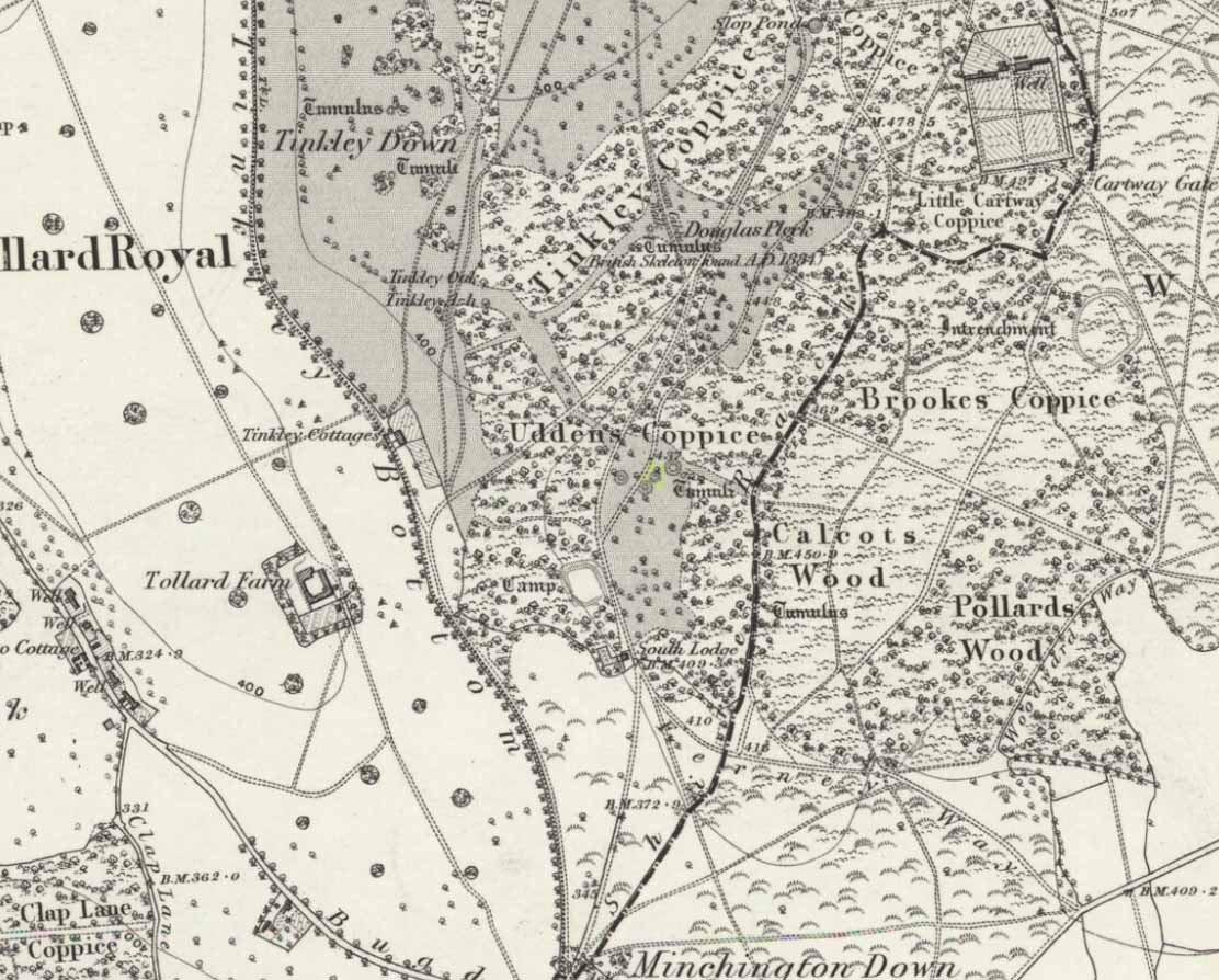
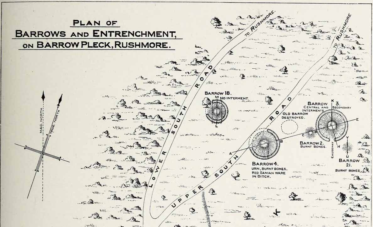
This long-lost burial mound was one in a large group of prehistoric tombs that were explored in the 19th century by the legendary antiquarian, General Pitt-Rivers. It had already been destroyed before the General came to live on his Rushmore estate in southern Wiltshire, but thankfully, his diligence as an inquirer prevailed and he was able to recover at least something of the old site. Shown on the 1889 OS-map of the area (despite already having been destroyed), in Pitt-River’s (1888) extensive writings he told how, in the scattered woodlands hereby, was
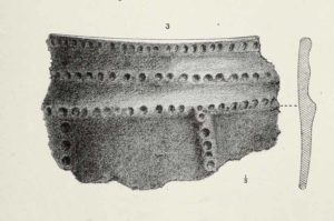
Pitt-Rivers 1888 site-mapOld Pleck Barrow urn
“a collection of large barrows near the South Lodge. They were covered with a thick grove of hazel and other underwood. One of the barrows—marked by a dotted circle (see sketch-map, left, PB)—had been destroyed before my arrival at Rushmore in 1880. The earth of the barrow had been removed and a good urn found in it, which had been broken and scattered, but I was fortunate enough to recover one of the fragments which had been preserved by the estate carpenter.”
From a sketch that was made of the urn remnant, Pitt-Rivers told how “the character of its ornamentation” resembled that on another urn found in one of the nearby tumuli.
References:
Pitt-Rivers, A.H.L.F., Excavations in Cranborne Chase, near Rushmore – volume 2, Harrison & Sons: London 1888.
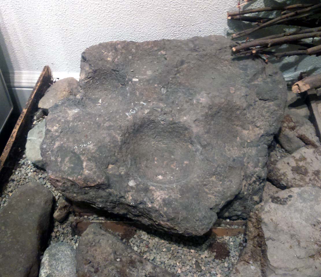
This is a curious stone and may not be the type of ‘cup-marked’ rock we’re used to. Maybe… It is presently housed in Stirling’s Smith Art Gallery & Museum, where a small note tells that is was originally found “on the top of the Ochils, near Mount Alt Farm, Path of Condie in 1893.” The stone was found at the same time, and adjacent to, a prehistoric collared urn—which implies it had an association with a cairn or cist, or burial site of some sort (which isn’t uncommon). However, the exact location of its original whereabouts has been forgotten.
Broken off from a larger piece of stone, the remaining piece of rock has six cup-markings cut into it, between one and three inches across. The smallest cup is what we might call a ‘normal’ size, but the rest of them get increasingly large and may have been more functional than purely mythic in nature. In a small note attached to the stone in the Museum, they add the interesting note that,
“There are…indications that in some places they may be related to transhumance: the practice of moving sheep, cattle and goats to higher pastures in the summer, where they may have been used to mark routes or sources of water.”
They may indeed – amongst a variety of other things too. But the suggested relationship with cattle occurs in stones found near Haworth, West Yorkshire, where large man-affected carved ‘cups’ such as the ones here, were known to be filled with milk at specific times of Nature’s calendrical rhythms, for the spirits of the place to give good fortune to the farmer and local people. We know of one instance where this practice still occurs and goes back generations in the same family. Examples of this animistic practice have also been found in the Scottish Highlands.
Tumulus (destroyed): OS Grid Reference – SE 099 321
Archaeology & History
Headley Farm urn
There are no longer any remains of the prehistoric burial site that once stood in one of the fields by Lower Headley Farm. We don’t know whether the site was a cairn, a tumulus, or just a stone-lined cist; but in all probability it would have been a low rounded hillock whose existence had long since fallen out of oral tradition. All that we do know is that in one of the fields by the farm, some very well preserved urns—either neolithic or Bronze Age by the look of it—were unearthed, indicating a site of prehistoric provenance.
The finds were described only briefly in the first edition of the Bradford Antiquary (1888) journal, where it was reported:
“During the spring of 1880 an interesting discovery was made by Mr. Abraham Craven, quarryman, of Thornton. The ‘find’ comprised three funeral urns, which Mr. Craven turned up while baring a portion of a field in Lower Headley Farm, the property of the trustees of Sowerby Grammar School. The discovery was made within a short distance of the surface, the pottery presenting undoubted indications of pre-Roman origin. From evidence collected upon the spot, and the appearance of the pottery, two of the urns were about 14in in height, 9in across the top, 11½in at the widest portion of the bowl, and 6in at the foot. One of the urns was of sun-burnt clay, with rude markings, the other having evidently been subjected to fire. No coins, personal ornaments, or other indications of civilisation, were found in the urns, but each one contained human dust and bones. From the fact that several other urns have been met with in the immediate vicinity, equally rude in type, evidence is not wanting that the picturesque mound upon which Headley is situate was inhabited at a very early period of British history.”
References:
Anonymous, “Valuable ‘Find’ at Headley, near Thornton,” in Bradford Antiquary, volume 1, 1888.
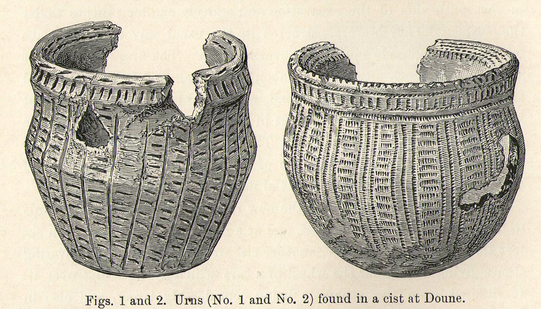
Somewhere in the woodland park, before the area was “ruined”, as Moray Mackay (1984) put it, by “sand and gravel workings”, and within 100 yards of the re-positioned Trysting Stone, there once remained the ruins of ancient tombs—probably neolithic or Bronze Age in nature. The ‘cists’ as they’re known (stone-lined graves), were described in several short articles at the beginning of the 20th century, shortly after their rediscovery. Drawing upon the initial article by Joseph Anderson (1902) in the Scottish Antiquaries journal, W.B. Cook (1904) wrote:
“The doubling of the (railway) line from Dunblane to Callander has necessitated the altering of a road at the Crofts, Doune, and on Tuesday, 8 May, while digging, the navvies came across two stone cists containing bones. The cists were made of stone slabs. On Thursday, the men came on another cist about five feet from the surface. It was 3 feet long and 2½ feet broad, composed of round stones, and a quantity of bones were found in it, and also an urn. Unfortunately a cart-wheel passed over the urn, smashing it. The pieces were, however, carefully collected and cemented and they are now in the possession of Mr Smith, Clerk of Works to the Caledonian Railway Company, Doune. One of the cists first found was quite empty, but the other contained a large number of human bones, the largest about 1½ inches long. The coffins were about 15 inches from the surface, and lay from east to west. They measured 2 feet 9 inches in length, and in breadth and depth about 18 inches. They are constructed of local stone, and near the spot there has been a dyke running from the burgh to the sand holes, as the foundation was visible when the soil was being removed. Some of the stones indicate that a house might have stood near the spot, but there had been no public burying-place nearer than at Kilmadock and at the little chapel of Inverardoch previous to 1784.”
In Mr Joseph’s (1902) article, he told us there wasn’t one, but two urns which, after some considerable effort, were reconstructed. I’m not a great lover of urns misself, although when found in conjunction with the dead, we must ask, what was in them (if anything) when they were placed with the deceased? Food? Herbal beverages? Shamanic potions? In this case, we don’t know; and so all we are left with is Mr Anderson’s description of them:
“Urn No.1 is of the usual type of the so-called ‘food-vessel’, 4¾ inches in height by 5 inches in diameter at the mouth, the lip slightly bevelled inward, and the whole exterior surface ornamented. The ornamentation consists entirely of lines impressed into the soft clay with what seems to have been the roughly broken end of a small twig about ⅛-inch in diameter. On the level of the lip there are two parallel lines of short scorings going completely round the upper surface. On the exterior surface there is a kind of slightly concave collar half an inch in width immediately under the brim, which is ornamented with short perpendicular indentations about a quarter of an inch apart. Underneath the collar the vessel expands slightly to the shoulder and then contracts to a flattened base of three inches in diameter. The part above the shoulder is slightly concave externally, but the scheme of decoration above and below the shoulder is the same, consisting of a series of short impressed lines scarcely half an inch in length ranged round the circumference in horizontal rows about a quarter of an inch apart, and crossed perpendicularly by lines about half an inch apart, not impressed, but scored into the clay. The perpendicular lines above the shoulder are more divergent than those below the shoulder, which converge towards the bottom in consequence of the tapering form of the lower part of the vessel. The paste is coarse, and mixed with small stones; the wall of the vessel is about a quarter of an inch thick, and the colour a reddish brown on both the exterior and interior surfaces, but quite black in the fractures exposing a section of its thickness.
“Urn No.2 is of the same wide-mouthed, thick-lipped form of the so-called food vessel type, 5 inches high and 5½- inches in diameter at the mouth. The lip is bevelled inwards, and the general shape of the vessel somewhat resembles that of No. 1, except in the lower part, which, instead of tapering to a flat bottom, narrows from the shoulder in a much more gradual curvature to the bottom. The ornamentation also is much more elaborate, though partaking of the same general character, inasmuch as it is a scheme of impressed markings, in bands arranged alternately in vertical and horizontal directions and covering the whole exterior surface of the vessel. On the bevel of the rim is a horizontal band of three lines of impressed markings, surmounted on the upper verge of the rim by a row of shallow oval impressions less than ⅛ of an inch apart. Under this there is a horizontal band of impressed markings as with the teeth of a comb, and below that the general scheme of ornament is carried out in alternate bands of about half an inch in width, running vertically from collar to base. The one set of these bands consists of three parallel rows of impressions of about ⅛ of an inch in width, and ⅛ of an inch apart, which seem to have been produced in the surface of the soft clay by a comb-like instrument, while the other set of bands has been produced by marking the spaces between the triple bands in the same way with a similar instrument, but placing the lines horizontally and closer together.”
A short distance from here, more cists were found. It’s possible that a prehistoric graveyard this way lay, countless centuries ago…
Folklore
Moray Mackay (1984) reports that the Doune fairs used to be held here.
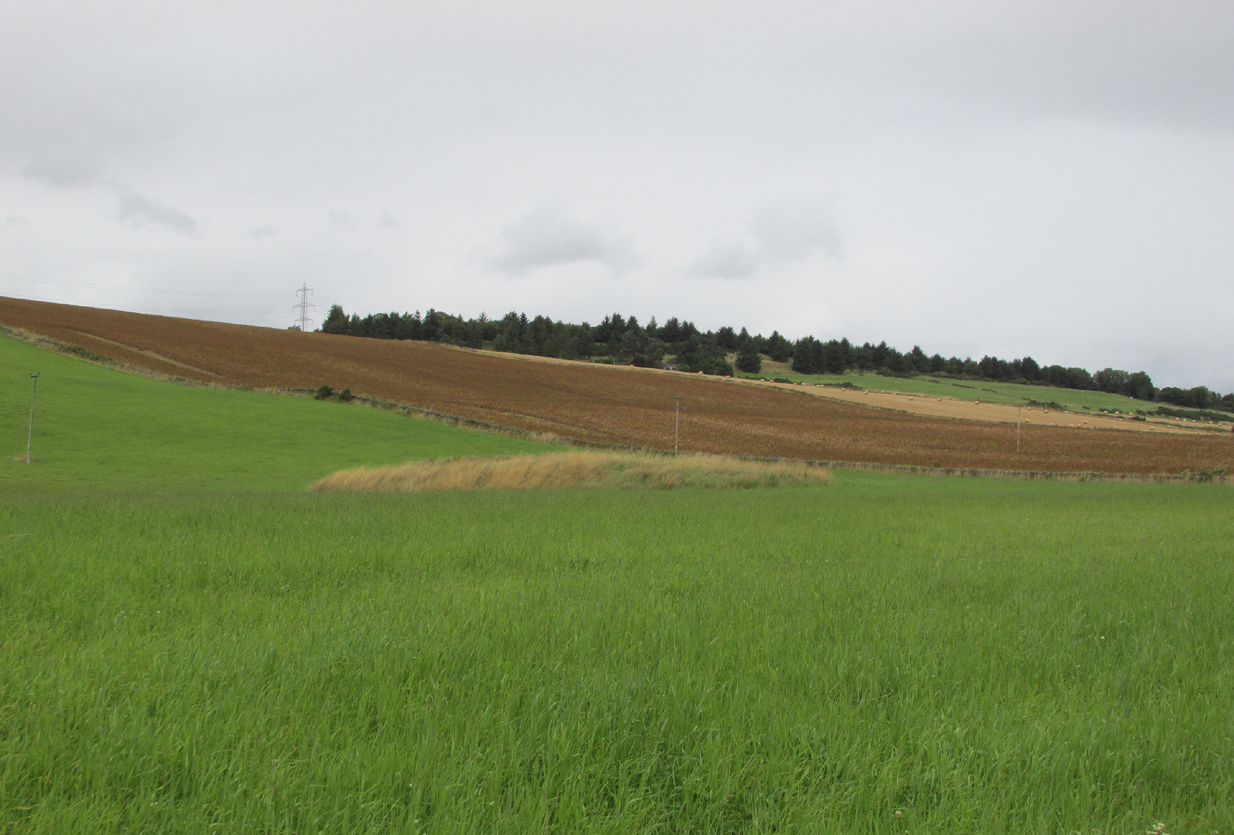
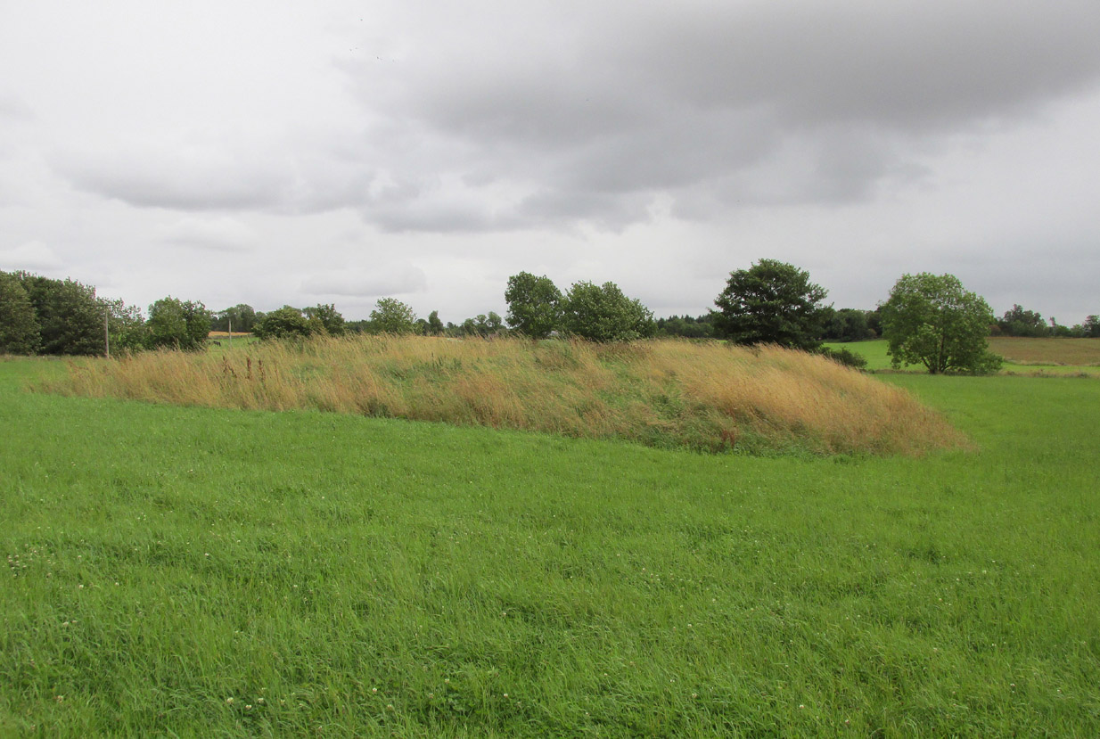
At Kirkton of Airlie, park next to the church and walk north eastwards along the track, past the houses Crabra and Cleikheim, and cross the burn by the small bridge and the mound will be seen ahead of you in the field.
Archaeology & History
A largely flat topped, rectangular mound, measuring, according to Canmore, 28 metres by 22 metres, 2.2 metres high on the west side and about ½ metre high on the east side. There is a quantity of rubble strewn on the top among which are two stone slabs, described in 1958 as being possible cist cover stones. The site has clearly suffered considerable disturbance.
The site highlighted in red on the 1865 6″ OS Map.The site from the north
Andrew Jervise, writing of the site in 1864 described it as having been 300′ in circumference and 6-7′ high before the owner started to remove it for agricultural ‘improvements’ around 1859. He described it as being sometimes known as the ‘Battle Cairn’. As part of the demolition of the mound, agricultural workers in October 1859 unearthed a large cinerary urn half filled with human bones and protected by a large sandstone flag. Jervise writes:
“After the urn was found, care was taken removing other parts of the hillock; and on further reducing the surface, the top of a large boulder was exposed, upon and around which the mass of loose stones and earth appear to have been raised which composed the mound. The boulder, as far as ascertained, measures about 6 by 7½ feet; and the urn was found about four feet to the north east of the stone. At the distance of about four yards from the spot where the urn was found, there appeared to be a separate circle, rudely constructed of stones and earth – stones predominating. In this circle, at pretty regular distances, deposits of human and animal bones were found; and each of these deposits appeared to have been protected by two flat stones set up in a triangular form, resembling (an inverted letter V)…none of the deposits was more than 8″ below the surface”. In February 1861, “..a stone cist was found a little to the south east of the boulder….it was 5 feet long by 2 in breadth. The lid, a single slab, was upwards of 6 feet in length…the depth of the cist was 2 feet….It was nearly empty, but one could see, from the soft, black, unctuous earth that was taken out of it, that it had contained a body.”
Jervise continues:
“The name of St. Medan’s Knowe is certainly significant, but, whether it would imply that the place had been that of his burial, or one of those of his ministry, and so been the original place of worship at Airlie – are interesting particulars upon which history and tradition are silent”.
Stone slabs on top
The Ordnance Survey Name Books, and the 25-inch OS map of 1865 record the finding, 20 yards to the west of the knowe, of a bronze spear head, which was at that time in the possession of a Mr Dixon, a merchant of Kirriemuir, which may go some way to explaining the alternative name of the site as ‘Battle Cairn’. The Name Books further record the testimony of a William Duncan that, ‘there have been 7 or 8 stone coffins and an urn found in the knowe, and that he believes a number more might be found if sought for, as the half of it is not yet excavated‘.
From the surviving evidence, it is very likely that Kirkton of Airlie was the centre of a cult of St. Madden (also known as ‘Medan’ and ‘Madan’), with the adjacent Holy Well, the (now destroyed) hamlet of St. Madden’s, and a Dewar’s land occupied by the hereditary custodians of St. Madden’s Bell. This site has no connection with St Medan’s Well at nearby Kirkton of Kingoldrum, that St Medan probably being a St Medana.
References:
Andrew Jervise, Notice of Antiquities in the Parish of Airlie, Forfarshire, Proceedings of the Society of Antiquaries of Scotland, June 1864.
Royal Commission on the Ancient and Historical Monuments of Scotland, The Archaeological Sites & Monuments of Central Angus, Angus District, Tayside Region, HMSO: Edinburgh 1983.
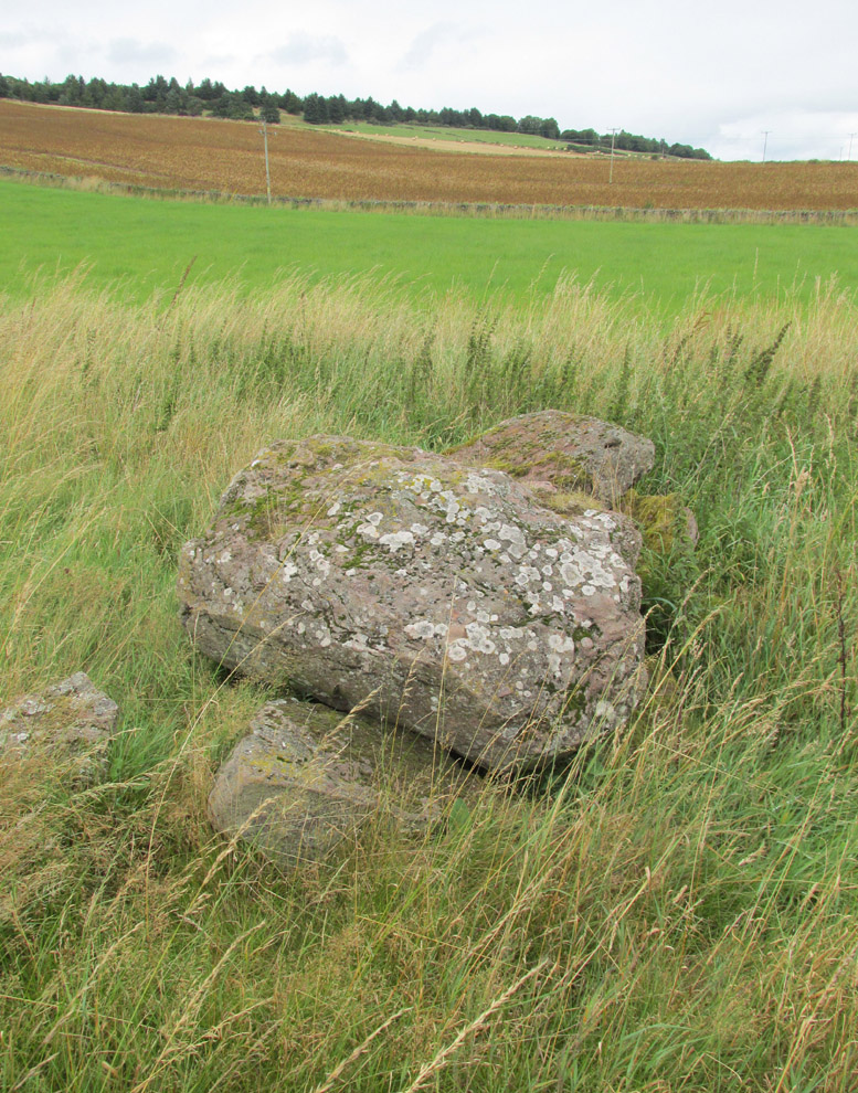
Take the same directions to locate the cup-and-ring stone of Ballochraggan 12. There are several rocks adjacent. The one immediately next to it, to the northeast, is the one you’re looking for. Be gentle and careful if you’re gonna look at it — deadly serious, be very careful indeed!
Archaeology & History
One of the most intriguing and most fascinating of all the prehistoric carvings I’ve yet to discover. Not that this was all my own work. If it hadn’t been for Paul Hornby, we might have simply walked past it as being little more than a single cup-marked stone—and in this area, single cup-marks tend to be little more than geological in nature.
After we’d looked over several of the registered carvings close by, I did my usual meandering back and forth, stroking stones and seeing if there were any carvings that had been missed by previous surveyors. And in walking past a small piece of smooth rock, a singular cupmark seemed to stand out. I walked past it, shouting across to my colleague.
“It looks like we’ve got a single cup-mark here Paul,” I said, “with possible half-ring.” Thankfully Mr Hornby gave it his better attention.
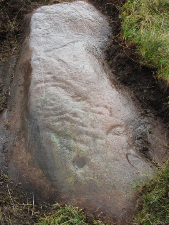
Mask Stone, with faint ‘urn’Close-up of features
The sun was still out and shining across the smooth rock surface, which tends to mean that you’re not seeing any carving on the stone quite as good as it actually is. Thankfully however, the sun was beginning to get lower and, when this happens, if we wet the rock, any carvings that might be there stand out much better. And this little fella just seemed to get better and more curious the more attention Paul gave it!
The first thing that became obvious were a series of faint carved lines above the single cup-mark. Initially these didn’t seem to merit much attention (straight lines on rock are usually more the product of geophysical action than that of humans), but as the rock got wetter, Paul saw something very distinct indeed.
“There’s a face on it!” he exclaimed. And indeed there was. A Rorschach response no doubt, but it was still very much like a face. This looked for all the world akin to the stylised olde English gentry sort of countenance, as in old cartoons. It was quite ‘distinct’, as such characters themselves insist on being! Yet around this initial face, more lines seemed to be emerging as the stone gave up more and more of its hidden story.
Standing back from an initial investigation, the carving was seen to consist of a triple-ring, but without the traditional ‘cup’ in its centre. Instead, the centre was marked simply by a small ‘dot’—perhaps, originally, being a small conglomerate hole formed as a result of another tiny harder fragment of stone falling away from its larger mass. But a ‘dot’ it was. The other carved ‘lines’ however, immediately below and attached to the triple-ring, gave us something almost unique—and another strong Rorschach response. As the photos clearly show, we have a distinct second ‘face’ made up of the same lines but in a quite different form. This ‘face’ has all the attributes we usually associate with pictures of mythical spirits, demons, or a mask—hence the name!
Paul took a series of fine photos, hoping that he could catch the image that our eyes could clearly see. And thankfully, his digital camera brought the image to life even better than our eyes did! The ‘mask’ is comprised of carved lozenge forms, akin to the more decorative ones we find at Kilmartin, and more especially around Newgrange, Ireland. We sat and talked about this: wondering and working out routes that we’d take over mountains and moors, from Ireland, to Kilmartin, then onto Ballochraggan, etching the same designs onto the rocks hereby and attaching similar mythic notions to them: of shamanism and kingship; underworlds and journeys—paradigms lost and certainly misunderstood in the non-polysemia of many modern academics.
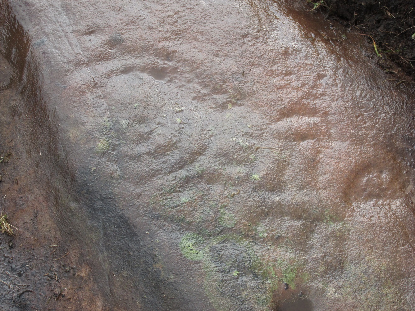
Lozenges and rings
…The stone here was still slightly covered over and, beneath the loose grasses, another feature emerged of another petroglyphic rarity. At the topmost western side of the rock a straight line ran across the surface, seemingly marked by the hand of man, with a curious little line almost doubling back on itself for just an inch or so, and then feeling to run down the stone, towards the concentric rings and the face below. When we stood back and took the photos, this line and its tracer took on a form that I’ve only seen echoed in one of the Netherlargie tombs at Kilmartin, Argyll, 44.4 miles (73km) to the west. It is very distinct.
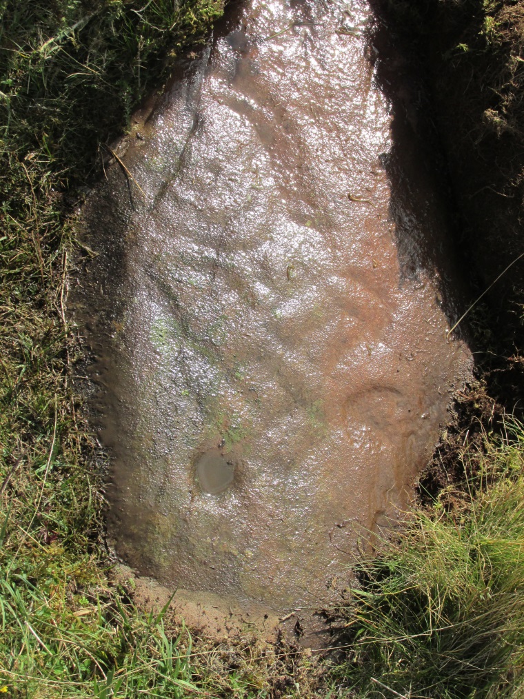
The beaker, rings & ‘face’
Spuriously ascribed as being ‘axe’ carvings (oh how archaeologists love this Rorschach projection), the Netherlargie North tomb cover-stone in Kilmartin has a series of burial ‘urns’ or beakers carved onto the rock, amidst a scattered collection of cup markings. (Beckensall 2005:73-4; Bradley 1983:92-3; Royal Commission 1971:68-70; Twohig 1972, etc) Here too at Ballochraggan we find another such symbol, but just a singular example, much larger and more clearly a beaker or urn, as are traditionally found within many old neolithic and Bronze Age tombs; although no tomb is immediately apparent at this Ballochraggan carving.
The entire carving is very faint indeed (you can’t even see it when you’re looking directly at it unless conditions are good) showing that it remained open to the elements for thousands of years. Other adjacent carvings lack the erosion that we find on this one, even on those which, as archaeologist Lisa Samson said, is “softer sandstone rock than this one”—implying that it’s one of the older carvings in this incredible cluster.
References:
Beckensall, Stan, The Prehistoric Rock Art of Kilmartin, Kilmartin Trust: Kilmartin 2005.
Bradley, Richard, Altering the Earth, Society of Antiquaries Scotland: Edinburgh 1993.
Royal Commission on the Ancient & Historical Monuments of Scotland, Argyll – volume 6: Mid-Argyll and Cowal, HMSO: Edinburgh 1971.
Twohig, Elizabeth Shee, The Megalithic Art of Western Europe, Clarendon: Oxford 1981.
Acknowledgments: Huge thanks again to Mr Paul Hornby for his considerable help with this site, and for use of his photos.
Access to these stones has, over recent years been pretty dreadful by all accounts. It’s easy enough to locate. Go into Calderstones Park and head for the large old vestibule or large greenhouse. If you’re fortunate enough to get one of the keepers, you may or may not get in. If anyone has clearer info on how to breach this situation and allow access as and when, please let us know.
Archaeology & History
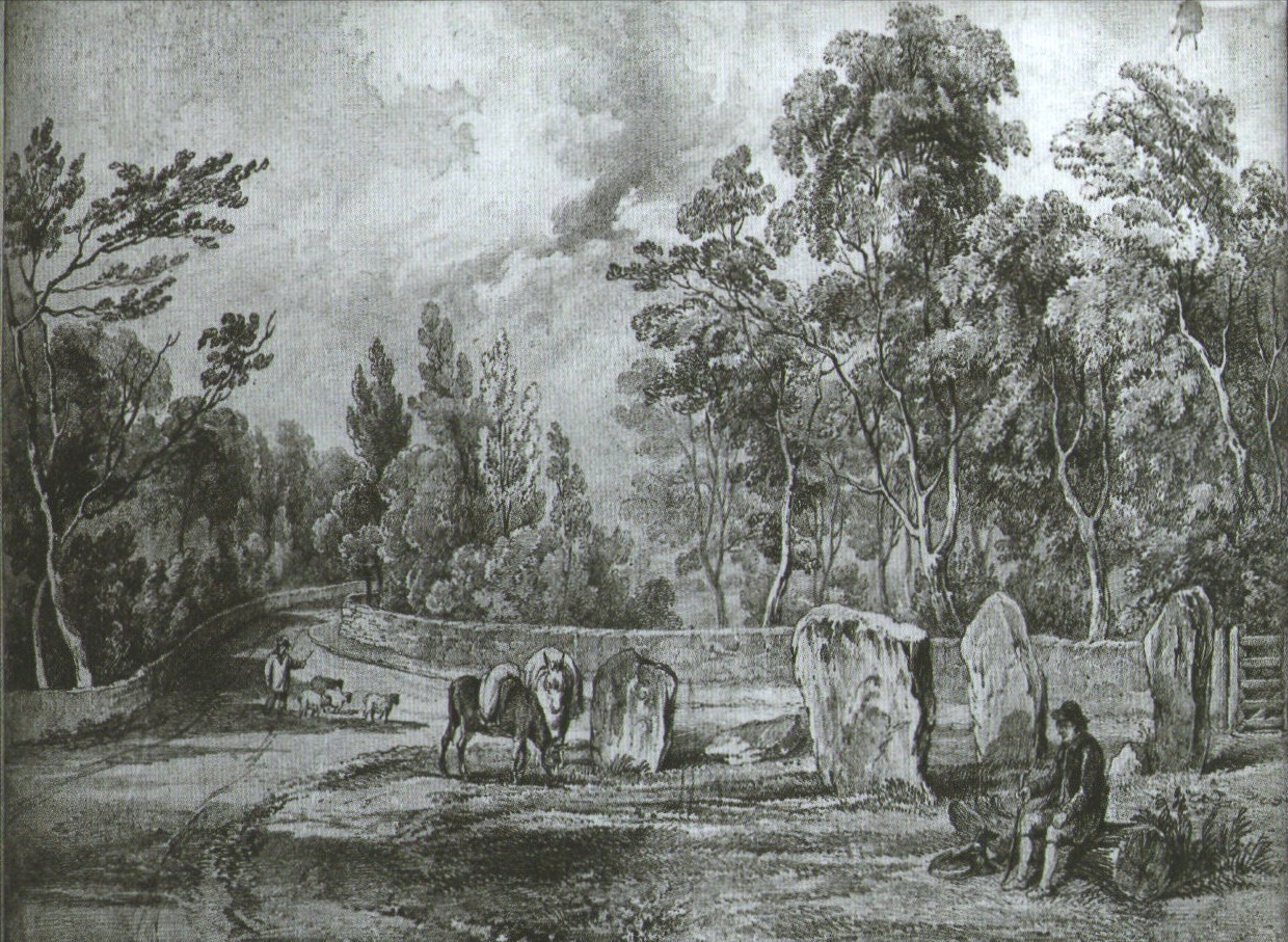
Earliest known drawing from 1825, showing the carvings
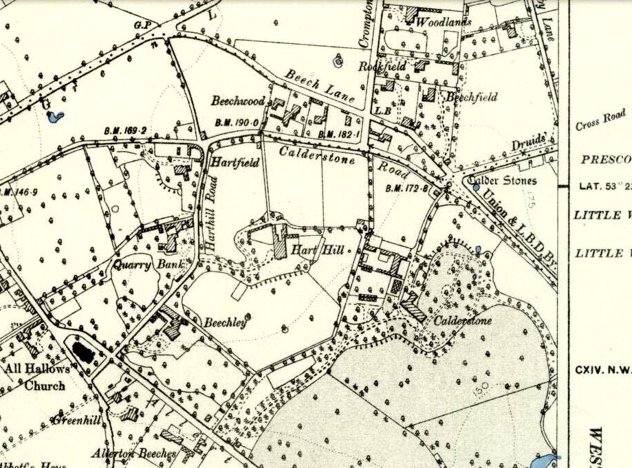
Marked on the 1846 Ordnance Survey map in a position by the road junctions at the meeting of township boundaries, where the aptly-named Calderstones Road and Druids Cross Road meet, several hundred yards north of its present site in Harthill Greenhouses in Calderstones Park, this is a completely fascinating site whose modern history is probably as much of a jigsaw puzzle as its previous 5000 years have been!
Thought to have originally have been a chambered tomb of some sort, akin to the usual fairy hill mound of earth, either surrounded by a ring of stones, or the stones were covered by earth. The earliest known literary reference to the Calderstones dates from 1568, where it is referenced in a boundary dispute, typical of the period when the land-grabbers were in full swing. The dispute was over a section of land between Allerton and Wavertree and in it the stones were called “the dojer, rojer or Caldwaye stones.” At that time it is known that the place was a roughly oval mound. But even then, we find that at least one of the stones had been taken away, in 1550.
Little was written about the place from then until the early 19th century, when descriptions and drawings began emerging. The earliest image was by one Captain William Latham in 1825. On this (top-right) we have the first hint of carvings on some of the stones, particularly the upright one to the right showing some of the known cup-markings that still survive. By the year 1833 however, the ‘mound’ that either surrounded or covered the stones was destroyed. Victorian & Paul Morgan (2004) told us,
“The destruction first began in the late 18th or early 19th century when the mound was largely removed to provide sand for making mortar for a Mr Bragg’s House on Woolton Road. It was at this time that a ‘fine sepulchral urn rudely ornamented outside’ was found inside.”
The Calderstones in 1840
The same authors narrated the account of the mound’s final destruction, as remembered by a local man called John Peers—a gardener to some dood called Edward Cox—who was there when it met its final demise. Mr Cox later wrote a letter explaining what his gardener had told him and sent it to The Daily Post in 1896, which lamented,
“When the stones were dug down to, they seemed rather tumbled about in the mound. They looked as if they had been a little hut or cellar. Below the stones was found a large quantity of burnt bones, white and in small pieces. He thought there must have been a cartload or two. He helped to wheel them out and spread them on the field. He saw no metal of any sort nor any flint implements, nor any pottery, either whole or broken; nor did he hear of any. He was quite sure the bones were in large quantity, but he saw no urn with them. Possibly the quantity was enhanced by mixture with the soil. No one made such of old things of that sort in his time, nor cared to keep them up…”
But thankfully the upright stones remained—and on them were found a most curious plethora of neolithic carvings. After the covering cairn had been moved, the six remaining stones were set into a ring and, thankfully, looked after. These stones were later removed from their original spot and, after a bit of messing about, came to reside eventually in the curious greenhouse in Calderstones Park.
Simpson’s “Stone 1” outer faceSimpson’s “Stone 1” inner face
The carvings on the stones were first described in detail by the pioneering James Simpson. (1865) I hope you’ll forgive me citing his full description of them—on one of which he could find no carvings at the time, but he did state that his assessment may be incomplete as the light conditions weren’t too good. Some things never change! Sir James wrote:
“The Calder circle is about six yards in diameter. It consists of five stones which are still upright, and one that is fallen. The stones consist of slabs and blocks of red sandstone, all different in size and shape.
“The fallen stone is small, and shews nothing on its exposed side; but possibly, if turned over, some markings might be discovered on its other surface.
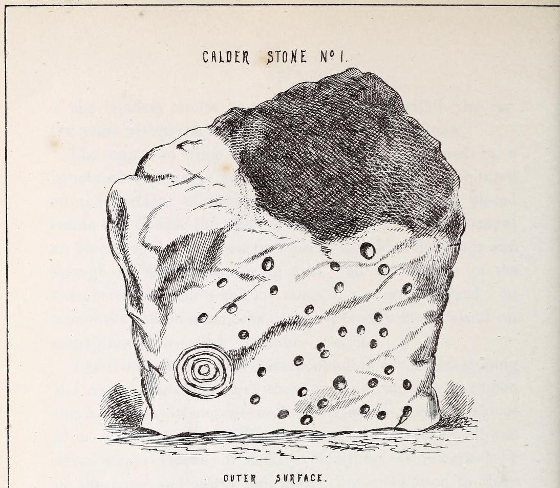
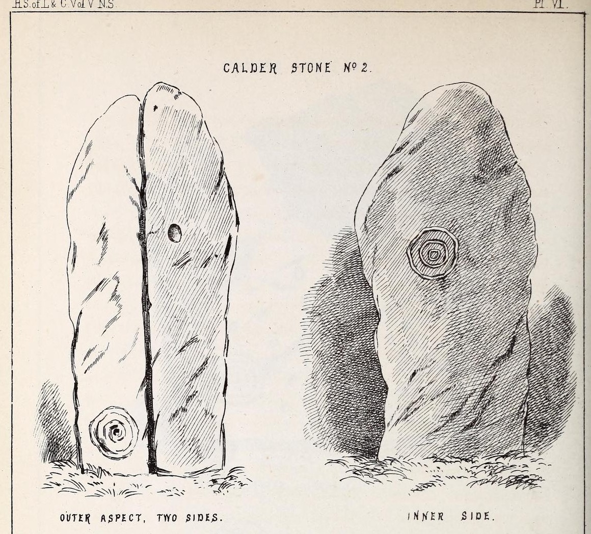
“Of the five standing stones, the largest of the set (No. I) is a sandstone slab, between five and six feet in height and in breadth. On its outer surface—or the surface turned to the exterior of the circle— there is a flaw above from disintegration and splintering of the stone; but the remaining portion of the surface presents between thirty and forty cup depressions, varying from two to three and a half inches in diameter; and at its lowest and left-hand corner is a concentric circle about a foot in diameter, consisting of four enlarging rings, but apparently without any central depression.
“The opposite surface of this stone, No. 1, or that directed to the interior of the circle, has near its centre a cup cut upon it, with the remains of one surrounding ring. On the right side of this single-ringed cup are the faded remains of a concentric circle of three rings. To the left of it there is another three-ringed circle, with a central depression, but the upper portions of the rings are broken off. Above it is a double-ringed cup, with this peculiarity, that the external ring is a volute leading from the central cup, and between the outer and inner ring is a fragmentary line of apparently another volute, making a double-ringed spiral which is common on some Irish stones, as on those of the great archaic mausoleum at New Grange, but extremely rare in Great Britain. At the very base of this stone, and towards the left, are two small volutes, one with a central depression or cup, the other seemingly without it. One of these small volutes consists of three turns, the other of two.
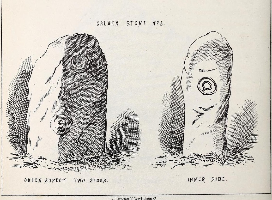
“The next stone, No. 2 in the series, is about six feet high and somewhat quadrangular. On one of its sides, half-way up, is a single cup cutting; on a second side, and near its base, a volute consisting of five rings or turns, and seven inches and a half in breadth ; and on a third side (that pointing to the interior of the circle), a concentric circle of three rings placed half-way or more up the stone.
“The stone No. 3, placed next to it in the circle, is between three and four feet in height; thick and somewhat quadrangular, but with the angles much rounded off. On its outermost side is apparently a triple circle cut around a central cup; but more minute examination and fingering of the lines shews that this figure is produced by a spiral line or volute starting from the central cup, and does not consist of separate rings. The diameter of the outermost circle of the volute is nearly ten inches. Below this figure, and on the rounded edge between it and the next surface of the stone to the left, are the imperfect and faded remains of a larger quadruple circle. On one of the two remaining sides of this stone is a double concentric circle with a radial groove or gutter uniting them. This is the only instance of the radial groove which I observed on the Calder Stones, though such radial direct lines or ducts are extremely common elsewhere in the lapidary concentric circles.
“The stone No. 4 is too much weathered and disintegrated on the sides to present any distinct sculpturings. On its flat top are nine or ten cups ; one large and deep (being nearly five inches in diameter). Seven or eight of these cups are irregularly tied or connected together by linear channels or cuttings…
“The fifth stone is too much disfigured by modern apocryphal cuttings and chisellings to deserve archaeological notice.
“The day on which I visited these stones was dark and wet. On a brighter and more favourable occasion perhaps some additional markings may be discovered.”
It wasn’t long, of course, before J. Romilly Allen (1888) visited the Calderstones and examined the carvings; but unusually he gave them only scant attention and added little new information. Apart from reporting that another of the monoliths had carvings on it, amidst a seven-page article the only real thing of relevance was that,
“Five of the Calderstones show traces, more or less distinct, of this kind of carving, the outer surface of the largest stone having about thirty-six cups upon it, and a set of four concentric rings near the bottom at one corner. One of the stones has several cups and grooves on its upper surface.”
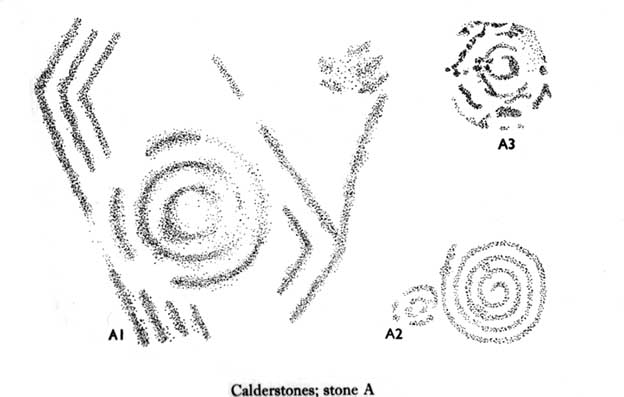
Carvings on Stone A (after Forde-Johnson)Carvings on Stone B (after Forde-Johnson)
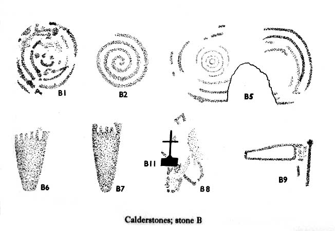
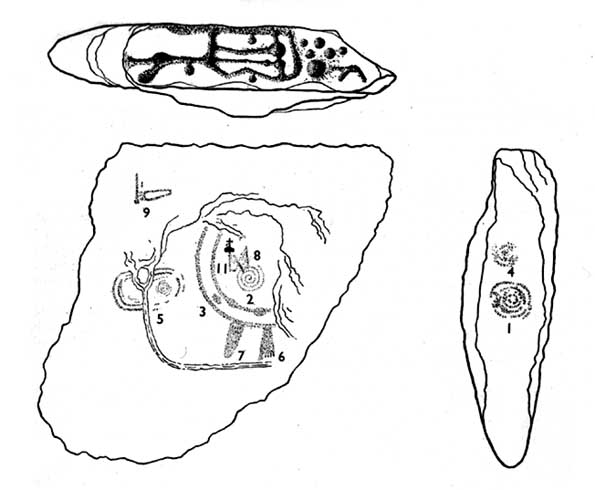
Unusual for him! The major survey of the Calderstone carvings took place in the 1950s when J.L. Forde-Johnson (1956; 1957) examined them in great detail. His findings were little short of incredible and, it has to be said, way ahead of his time (most archaeo’s of his period were simply lazy when it came to researching British petroglyphs). Not only were the early findings of Sir James Simpson confirmed, but some fascinating rare mythic symbols were uncovered that had only previously been located at Dunadd in Argyll, Cochno near Glasgow, and Priddy in Somerset: human feet – some with additional toes! Images of feet were found to be carved on Stones A, B and E. A carved element on Stone C may even represent a human figurine—rare things indeed in the British Isles!
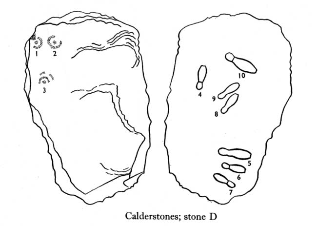
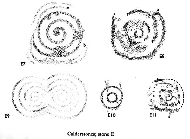
Carvings on Stone DCarvings on Stone E
The detailed sketches here are all from Forde-Johnson’s 1957 article, where five of the six stones were found to bear petroglyphs (the sixth stone has, more recently, also been found to also possess faint carvings of a simple cup-mark and five radiating lines).
Elements on Stone C (after Forde-Johnson)More elements on Stone C (after Forde-Johnson)
The date of the site is obviously difficult to assess with accuracy; but I think it is safe to say that the earlier archaeological assumptions of the Calderstones being Bronze Age are probably wrong, and the site is more likely to have been constructed in the neolithic period. It’s similarity in structure and form to other chambered tombs—mentioned by a number of established students from Glyn Daniel (1950) to Frances Lynch—would indicate an earlier period. The fact that no metals of any form have ever been recovered or reported in any of the early accounts add to this neolithic origin probability.
There is still a lot more to be said about this place, but time and sleep are catching me at the mo, so pray forgive my brevity on this profile, until a later date…
Folklore
Curiously, for such an impressive site with a considerable corpus of literary references behind it, folklore accounts are scant. The best that Leslie Grinsell (1976) could find in his survey was from the earlier student C.R. Hand (1912), who simply said that,
“They were looked upon with awe by the people about as having some religious significance quite beyond their comprehension.”
There is however, additional Fortean lore that has been written about these stones and its locale by John Reppion (2011).
Ashbee, Paul, The Bronze Age Round Barrow in Britain, Phoenix House: London 1960.
Baines, Thomas, Lancashire and Cheshire, Past and Present – volume 2, William MacKenzie: London 1870.
Beckensall, Stan, British Prehistoric Rock Art, Tempus: Stroud 1999.
Beckensall, Stan, Circles in Stone: A British Prehistoric Mystery, Tempus: Stroud 2006.
Cowell, Ron, The Calderstones – A Prehistoric Tomb in Liverpool, Merseyside Archaeological Trust 1984.
Crawford, O.G.S., The Eye Goddess, Phoenix House: London 1957.
Daniel, Glyn E., The Prehistoric Chamber Tombs of England and Wales, Cambridge University Press 1950.
Faulkner, B.M., “An Analysis of Three 19th-century Pictures of the Calderstones,” in Merseyside Archaeological Journal, volume 13, 2010.
Forde-Johnson, J.L., “The Calderstones, Liverpool,” in Powell & Daniel, Barclodiad y Gawres: The excavation of a Megalithic Chambered Tomb in Anglesey, Liverpool University Press 1956.
Forde-Johnson, J.L., “Megalithic Art in the North West of Britain: The Calderstones, Liverpool,” in Proceedings of the Prehistoric Society, volume 23, 1957.
Grinsell, Leslie, Folklore of Prehistoric Sites in Britain, David & Charles: Newton Abbot 1976.
Hand, Charles R., The Story of the Calderstones, Hand & Co.: Liverpool 1912.
Herdman, W.A., “A Contribution to the History of the Calderstones, near Liverpool,” in Proceedings & Transactions of the Liverpool Biological Society, volume 11, 1896.
Morgan, Victoria & Paul, Prehistoric Cheshire, Landmark: Ashbourne 2004.
Nash, George & Stanford, Adam, “Recording Images Old and New on the Calderstones in Liverpool,” in Merseyside Archaeological Journal, volume 13, 2010.
Picton, James A., Memorials of Liverpool – 2 volumes, Longmans Gree: London 1875.
Simpson, James, Archaic Sculpturings of Cups, Circles, etc., Upon Stones and Rocks in Scotland, England and other Countries, Edmonston & Douglas: Edinburgh 1867.
Taylor, Isaac, Words and Places, MacMillam: London 1885.
Stewart-Brown, Ronald, A History of the Manor and Township of Allerton, Liverpool 1911.
Acknowledgements: With huge thanks to the staff at Calderstones Park; thanks also to the very helpful staff at Liverpool Central Library.
In a region that is full of prehistoric remains, we find here another example of another megalithic site that was sadly destroyed, not too long ago by the scale of things. Found in association with a large prehistoric urn, we are thankful to have a couple of early local history accounts that describe the place. The stone was obviously of some considerable height and bulk, though I can find no specific references to the dimensions of the monolith. It was described effectively in the middle-half of the 19th century by Andrew Jervise (1853), who told us:
“‘The Stannin Stane of Benshie’, which stood for unknown ages…was demolished by gunpowder about half a century ago, and the spot is now covered by luxuriant crops of corn. This rude monument of antiquity is supposed to have been about twenty tons in weight; and at a considerable depth below it, a large clay urn, measuring about three feet in height and of corresponding circumference, was found containing a quantity of human bones and ashes. Like its rude protector, however, the urn was broken to pieces; and, beyond the mere fact of its discovery, nothing authentic, as to either the style of its manufacture, or the precise nature or state of its contents, is preserved.”
More than 30 years later, A.J. Warden (1884) and then J.G. MacPherson (1885) all but copied Mr Jervise’s words, adding no further information.
From some reason, a small chapel dedicated to St. Ninian (NO 41567 51932) was built about 100 yards or so to the southwest of the old standing stone. Its ruins are still to be seen. Whether this was an attempt to divert local people away from their animistic ecocentricism at the stone, into the more ecocidal egocentricism of the incoming christian cult (as was/is their common practice), we may never know for sure.
Folklore
The local name of this stone, ‘The Stannin Stane of Benshie’, indicates simply that this was “the standing stone at the hill of the faerie folk” (or variations thereof) and suggest it stood upon or next to a mound. I can find no immediate reference to stories of the little people here, and their whisper may have faded into unconscious memory. Does anyone know more about this place?
References:
Jervise, Andrew, The History and Traditions of the Land of the Lindsays in Angus and Mearns, Sutherland and Knox: Edinburgh 1853.
MacPherson, J.G., Strathmore: Past and Present, S. Cowan: Perth 1885.
Royal Commission on the Ancient & Historical Monuments of Scotland, The Archaeological Sites and Monuments of Central Angus, Angus District, Tayside Region, Edinburgh 1983.
Warden, Alex J., Angus or Forfarshire: The Land and People – Descriptive and Historical – volume 4, Charles Alexander: Dundee 1884.
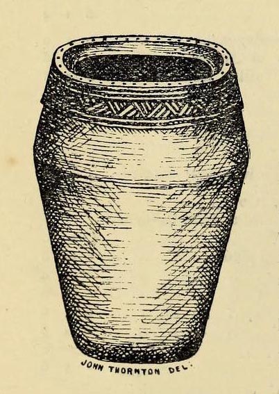
Decorated prehistoric urn from St John’s Green tumulus
In a prehistoric burial mound that was destroyed by the usual self-righteous arrogance of industrialists, this well-decorated urn or beaker in the old photo (right) was somehow retrieved. Included in Dave Clarke’s (1970) major survey on such vessels (as an Abercrombie type A, no less!), the remains came to light in January 1930, “during the laying of a gas main under the west footpath of Flagstaff Road, about 100 yards south of St. John’s Green.” Although the barrow or tumulus had already been levelled, sheer diligence and care on behalf—one believes—of antiquarian M.R. Hull saved the vessel from an otherwise inevitable doom!
In Mr Hull’s (1946) article on to this and other similar finds in Essex, he described how the urn, about seven inches high,
“…stood upright in the side of the trench, only 18in below the surface. The ground had been disturbed before, and one side of the beaker was badly damaged… The clay was fine, but contains some sparse grit, fairly large and white. It is light brown-red in colour and black in the break. The body is decorated all over with impressed lines, some done with the print of a stick or bone, some in an indefinable way which produces an almost maggot-like impression of varying length, and some with the end of a comb, as on the Type B beakers, but the teeth are oblong (very narrow) instead of square—the comb in fact, was very thin, at least at the point.”
References:
Clarke, David L., Beaker Pottery of Great Britain and Ireland – volume 2, Cambridge University Press 1970.
Hull, M.R., “Five Bronze Age Beakers from North-East Essex,” in Antiquaries Journal, volume 26, Jan-April 1946.
Tumulus (destroyed): OS Grid Reference – TM 0628 2022
Archaeology & History
Alresford Hill urn
In a region well known for the finding of early British remains (Belloc 1905), another prehistoric burial mound was destroyed in the Essex landscape simply due to ignorance and neglect. Thankfully once more we have local antiquarians and an astute schoolgirl for discovering and preserving a record of this site, otherwise we’d have no record of the place at all! Described in M.R. Hull’s (1946) article on some of the Bronze Age relics of the area, he told how a well-preserved urn in the edge of the tumulus,
“was found in June 1942 by a schoolgirl, Miss Anne Pilkington, on the top of the hill overlooking Alresford Creek and the Colne Estuary, about 70 yards northwest of Bench Mark 74.8 and 560 yards slightly west of south from Alresford church, west of the road to the creek and south of the lane running west along the north side of the field. This is the northern limit of a huge gravel-pit. She noticed the vessel standing upright in the side of the pit and recovered it. Nothing else was noticed…
“Afterwards the diary of our late Fellow, Mr P.G. Laver came into my hands and I find under the date 8th July, 1922, that he noticed, when motoring past the site, ‘a definite tumulus, but much ploughed down, now barely 18ins above the field level. It is close to the road through the field, the centre being roughly 20 yards S of the road and about 200 yards from the road to the ford.’ The sketch-plan leaves no doubt on the identity of the site.”
Annoyingly though, Mr Hull didn’t think it worthwhile to reproduce this alleged sketch-map. He did however give us a good description of the urn and its position in the ground, saying,
“The vessel is stated to have been about 5ft below the surface when found, but I am not certain whether the top-soil had been removed or not. The clay is fine, burnt light red, but black within, and the whole body is covered with horizontal lines impressed in exactly the same way as (those on the Flag Inn urn), but much less clearly. The base is slightly hollowed beneath and is not far from having a foot-ring.”
Folklore
Mr Hull (1946) also made an interesting comment on the views of local people about the site where Anne had found this urn, reminding me of what Highland and hill folk would have put down to faerie-lore, though no such memory was noted. He told:
“On enquiry I learnt that no one had observed a mound at the spot, but that it had been observed that exactly there the corn, when the field was cultivated, grew taller and greener in a large round patch”!
References:
Belloc, Hilaire, The Old Road, Archibald Constable: London 1905.
Hull, M.R., “Five Bronze Age Beakers from North-East Essex,” in Antiquaries Journal, volume 26, Jan-April 1946.