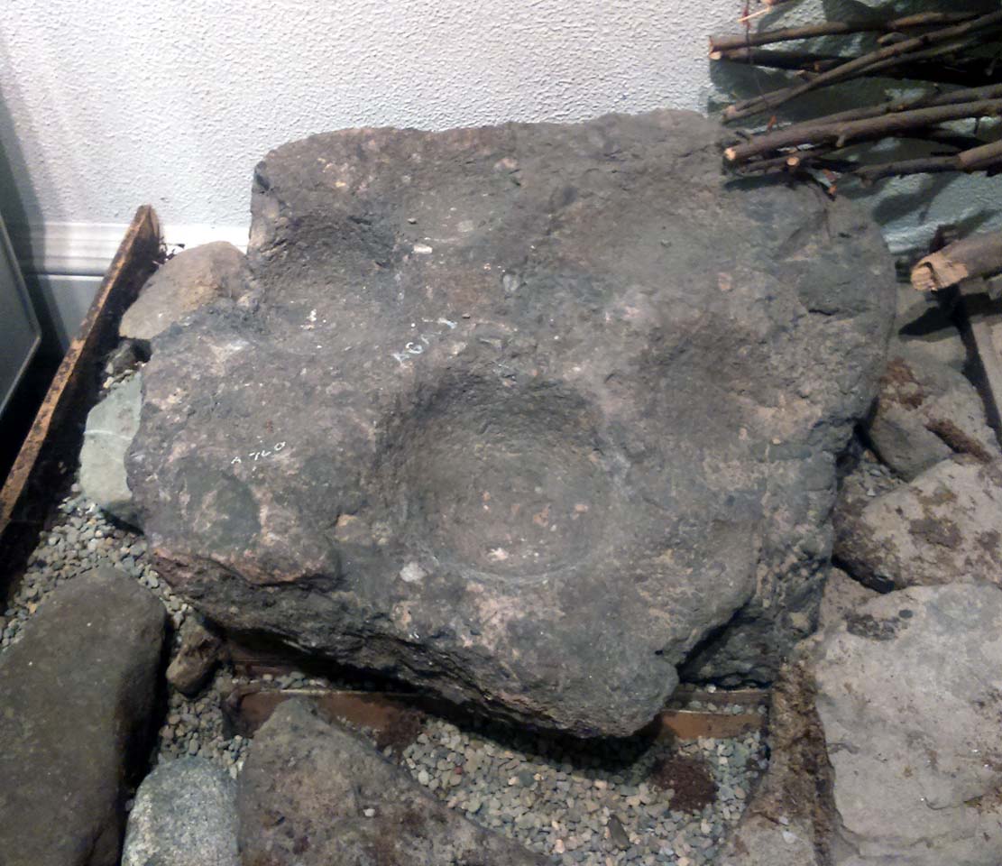
This is a curious stone and may not be the type of ‘cup-marked’ rock we’re used to. Maybe… It is presently housed in Stirling’s Smith Art Gallery & Museum, where a small note tells that is was originally found “on the top of the Ochils, near Mount Alt Farm, Path of Condie in 1893.” The stone was found at the same time, and adjacent to, a prehistoric collared urn—which implies it had an association with a cairn or cist, or burial site of some sort (which isn’t uncommon). However, the exact location of its original whereabouts has been forgotten.
Broken off from a larger piece of stone, the remaining piece of rock has six cup-markings cut into it, between one and three inches across. The smallest cup is what we might call a ‘normal’ size, but the rest of them get increasingly large and may have been more functional than purely mythic in nature. In a small note attached to the stone in the Museum, they add the interesting note that,
“There are…indications that in some places they may be related to transhumance: the practice of moving sheep, cattle and goats to higher pastures in the summer, where they may have been used to mark routes or sources of water.”
They may indeed – amongst a variety of other things too. But the suggested relationship with cattle occurs in stones found near Haworth, West Yorkshire, where large man-affected carved ‘cups’ such as the ones here, were known to be filled with milk at specific times of Nature’s calendrical rhythms, for the spirits of the place to give good fortune to the farmer and local people. We know of one instance where this practice still occurs and goes back generations in the same family. Examples of this animistic practice have also been found in the Scottish Highlands.
This ancient fort could once be seen in the ancient woodlands on the western side of the Mill Glen, above the village, going into the Ochils—but it was completely destroyed, as usual, by the Industrialists when they quarried the entire structure out of existence. It was a big thing too, by all accounts. When Stewart Cruden (1964) saw it, shortly before its final demise, it was still impressive to look at. He told that the fort consisted of a deep rock-cut ditch with a stone wall on the inside and the remains of a stony rampart on the outside. Although damaged it still measured 300 feet across. Its interior contained an almost precise circular enclosure, more than eighty feet across inside the remains of a large stone wall some twelve feet thick.
Nearly a hundred years earlier, Miss Christian MacLagan (1875) told it to be much bigger! Not only did she report how locals remembered a stone roof on top, but it possessed three concentric circular walls, thirty-five apart, with the central area eighty feet in diameter—much as Cruden later reported. However, even in MacLagan’s day, she told how many of the stones from the fort were being used to construct sheepfolds. This destruction was being lamented by the local historian William Gibson (1883), who wrote:
“On the west side of the burn, and overtopping the village, stands the beautiful Castle Craig, wooded to the top, and on which stood, in ancient times, a round Pictish fortress, the traces of which can still be distinctly seen. This craig is, I think, one of the most picturesque objects on the Alva estate, and it is a very great pity that it should be so disfigured by the extensive quarrying operations that are being at present carried on at it.”
On the top of the quarry edges can still be found old walled remains crumbling at the edge of the huge cliffs, but these are unlikely to have been attached to the ancient fortress, and may just be the fragmentary memories of the sheepfolds built from the old fort.
Folklore
Tradition told that this was one of the old forts of the Picts who lived in the Ochils. If it was a fort, then the Pictish tradition is probably true. Old lore also told that some of the stones from the fort were used in the construction of Stirling Castle, 7.8 miles (12.6km) to the west.
References:
Corbett, L., et al., The Ochil Hills, Forth Naturalist & Historian 1994.
Cruden, Stewart H., “Castle Craig, Tillicoultry,” in Discovery & Excavation Scotland, 1964.
Feacham, Richard, Guide to Prehistoric Scotland, Batsford: London 1977.
Maclagan, Christian, The Hill Forts, Stone Circles and other Structural Remains of Ancient Scotland, Edinburgh 1875.
Royal Commission on the Ancient & Historical Monuments, Scotland, Inventory of Monuments and Constructions in the Counties of Fife, Kinross and Clackmannan, HMSO: Edinburgh 1933.
Royal Commission on the Ancient & Historical Monuments, Scotland, The Archaeological Sites and Monuments of Clackmannan District and Falkirk District, Society of Antiquaries of Scotland 1978.
Watson, Angus, The Ochils: Placenames, History, Tradition, PKDC: Perth 1995.
Take the same directions as if you’re gonna find the Pendreich Moor cairn up the hills behind and north of Stirling University (there are 2 very close to each other). Once upon the cairned hill, walk dead straight WNW for 100 yards or so, or down the slope into the small valley, then westwards. You’ll hit an overgrown length of very old walling. Keep walking along here and, below it, you’ll find these stones laying down in the shallow grasses on the south-side of the all-but dried stream. The large Cuparlaw Wood cairn is 0.4 miles west of here.
Archaeology & History
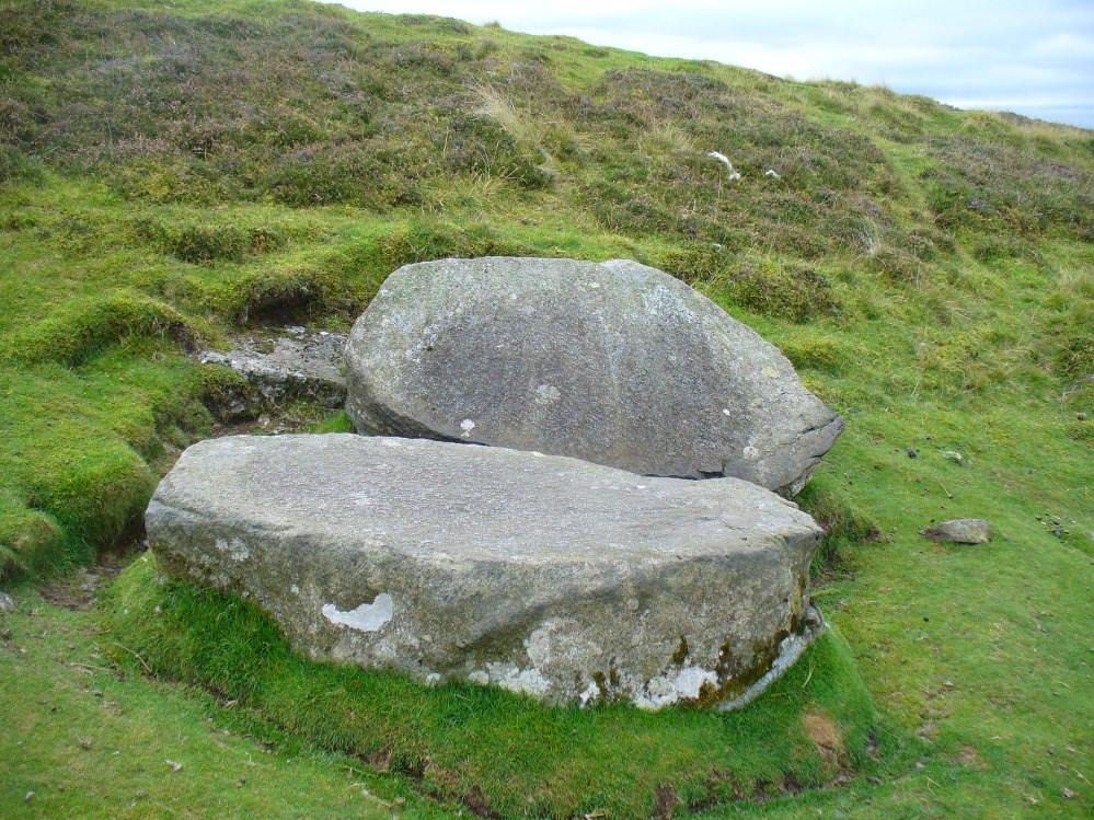
The Split Stone, Pendreich
This is something of an anomaly. There is no previous written history about the place (that I can find) and archaeologists and historians on The Prehistoric Society and CBA forums can offer no other explanation when asked: is this a standing stone that, many centuries ago, was cut and prepared to be erected, but never made it into the intended monument? (wherever that might have been) And so, I offer it onto TNA and ask the same of any readers, geologists or archaeo’s who might have an explanation for this curious, large split piece of stone, that lays silently on the western moorland edges of the Ochils, asking the same question.
When I first came across this site I was simply perplexed as to the why’s and wherefore’s of who had cut such a large rock into approximate halves. I must have walked around it many times, puzzling what the purpose would have been of doing such a thing, and how long ago the ‘split’ had been performed. About a year later I ventured up again and, when leaving to head back into Stirling, found no resolution to my puzzlement. It had me truly stumped!
It wasn’t until I visited the prehistoric Witches’ Stone about 15 miles away near Monzie Castle last year, that one of those ‘eureka!’ events occurred. The last thing on my mind was the curious split rock above Bridge of Allan. Fellow antiquarian Paul Hornby and I were taking photos of the Witches’ Stone, when one of us remarked how unusually flat and smooth one face of this upright standing stone was – in fact, incredibly flat and smooth – and that’s when it hit me! As I walked round and round the Witches’ Stone, the similarity between this upright example and the one laid on the ground about 15 miles away got stronger and stronger.
The Split Stone, looking east
A week or two later, archaeology student Lisa Samson and I went back to the Split Stone to have another look at it. Without doubt, the appearance and size and type of rock were one and the same. The only real difference between the Witches Stone and this Split Stone on the edge of Pendreich Moor, is that one stands upright and the other is laid down.
As you can see from the photos, we have a large rock, 5-6 feet long, which was, at some time many centuries ago, split almost straight down the middle, following a natural line of weakness or mineral deposit running through the stone. In all probability this was a standing stone prepared and ready to be used in some neolithic or Bronze Age monument not too far way—but for some reason it never made the journey to its intended spot.
The age of this split rock needs assessing correctly by geologists. Walking around the earthfast halves, it is difficult to see any recent evidence of mason marks that might help us determine when the rock was cut like this. In looking at erosion marks on cut-and-dressed quarried stone from post-medieval periods, we find no equivalent scars on this Split Stone. There is what may be faint evidence of some cuts into the stone at the top and side, but these are very debatable; and very probably it seems that the stone must have been cut a very long time ago, thousands of years back, in order to erode all obvious mason marks. But it would be good to get a geologist to have a look and confirm or deny such things.
…And, as if this isn’t a mystery unto itself: walk across the dried stream and go up the slope right in front of you immediately north. There’s a small, almost level ridge you’ll reach after 30 yards up, before the hill then rises further. If you notice, in the grasses and heather around you, there’s much more of the overgrown ‘walling’ here along this ridge—and some of it, with dips here and there and about three feet tall in places, is in a circle! It’s man-made, it’s a ring of stones, you can see it on GoogleEarth pretty clearly, and it’s not in any official record books.
The huge Pendreich Muir monolith, with Dumyat in the background
Nearly 600 yards west of the old Sheriffmuir Road (between Bridge of Allan to Greenloaning), you’re best approaching it up the zigzaggy lane from above Stirling Uni until it levels out beyond the main wooded area where the hills open up on either side of you. There’s a little touristy parking spot further along the road, just below a small wooded bit. Go past this and look out for the small peaked hill nearly a half-mile NW on your left. Take whichever footpath you fancy (if you see one) and get to the top of that hill!
Archaeology & History
This is a wonderful spot, located at the highest point on this small moorland region on the western edge of the Ochil Hills. I haven’t found too much written about this once proud, but now fallen monolith — which seems unusual considering its size, cos it’s huge! It would have stood out and been visible for miles around. Quite when it was felled, I cannot find. The only info I’ve got here (Royal Commission 1963) tells:
“Lying recumbent on a grassy patch among the heather, it is a four-sided pillar measuring 13ft in length, a maximum of 4ft 6in across the wider side, and a maximum of 1ft 6in across the narrower side.”
In enquiring about the nature of this stone a few years ago, a local chap who called himself ‘Wharryburn’ wrote to say, “I believe the laid-out stone is a fallen standing stone. My grandfather was gamekeeper at Airthrey Estate and responsible for the shooting on the moor there he passed it to my father etc… It’s the local volcanic stone, not an ice-dropped erratic. There are also a few biggish stones at points around that I tried to make some sense out of a few years ago, but no luck.”
The great hill of Dumyat rises to its east; a short distance north is a megalithic stone row with its upright Wallace Stone; whilst the overgrown prehistoric cairns of Pendreich 1, 2 and 3 live on the small hillocks a few hundred yards to the south.
References:
Royal Commission on the Ancient & Historical Monuments of Scotland, Stirlingshire – volume 1, HMSO: Edinburgh 1963.
From Menstrie, walk up the path behind the post office and head up onto the hills, following the track that runs up alongside the Menstrie Burn. After about 500 yards, crossing a stream, the path has a sort of hairpin kink and, shortly past this a smaller path leads off up into the grasslands on your left. The standing stone can be seen up this path about 100 yards up.
Archaeology & History
The Lipney Stone
We came across this small standing stone, less than four feet high, after running and jumping down the steep eastern slope of Dumyat at some speed — or rather, Naomi came across the little thing and then told me about it after I’d run round and further down the slope towards the upper stretches of the Menstrie Burn (I was knackered!).
It’s a curious little thing inasmuch as it stands here alone, with no other companions close by; although there were a number of other stones scattering the grasslands hereabouts and other stones may await discovery. Little seems to have been said of the site. The Canmore record tells:
“It measures 1.1m in height, 0.7m in breadth and 0.4m in thickness, and is aligned with its long axis NE-SW. It rises with straight sides and leans to the SE.”
There are extensive remains of earthworks scattering the slopes hereby, though much of this seems medieval in nature. Any further information about this old stone would be much appreciated!