‘Standing Stone’ (destroyed): OS Grid Reference – TQ 282 804
Also Known as:
Oswald’s Stone
Ossul Stone
Archaeology & History
Described as far back as 1086 in Domesday — as Osulvestane — this old stone was mentioned in numerous old documents, but its ancestral importance had long since been disregarded by modern Londoners. Probably heathen in nature, the stone was referenced in various texts as Osulfestan (1167 and 1168), Osolvestone (1274), Oselstone (1290), Ossulstone (1610) and variants thereof all the way through literary accounts until the emergence of the self-righteous judaeo-christian Industrialists in the 19th century, bringing about its destruction. (they’ve never really stopped to be honest) The grand place-name masters Gover, Mawer & Stenton (1942) told us a bit about the old stone, saying:
“This was probably a stone marking the meeting-place of the Hundred. It has been surmised that its site was near the present Marble Arch, but in 1484…there is mention of Westmynster lane leading between Tyburn and les Osilston Pyttes. Westmynster lane is the later Park Lane…and in a Grosvenor Estate map of 1614… Osolstone is marked as a field-name about halfway down Park Lane on the east side just beyond the present South” Street.
According to the Victoria County History of London (volume 1), the stone was actually in position up to 1822, “but was then earthed over.” However, it was resurrected during the construction of the modern Marble Arch in 1851 and stood up against the monument for several years until its eventual demise around 1869.
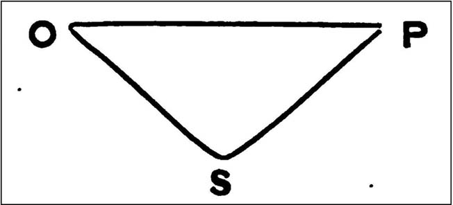
W.H. Black’s isosceles triangle, showing Oswulfs Stone at ‘O’
One intriguing commentator on Oswulf’s Stone suggested a more recent Roman origin, due to him finding that the monolith played an important part in a precise isosceles triangle. In a talk given to a meeting of the London & Middlesex Archaeological Society on 10 January, 1870, William Black (1871) reminded his audience that he had,
“already shown that the sculptured and inscribed marble sarcophagus or sepulchral monument…at Clapton had served as a geometric point from which numerous measures extended to boundary points of Hackney and its neighbouring townships.”
And when he explored this potential at Oswulf’s Stone he found even more geometry. Alexander Thom and Alfred Watkins would have been proud of him! His research led him to compare two relative antiquities, both of which he deemed to be Roman:
“Of these two monuments the first is Ossulstone, from which the great Hundred…derives its name. Its position and identity I had discovered some years ago by reversing my method of determining the uses of geometric stones: that is, by finding, from the proper boundary points, a centre where lines of proper quantities unite, so as to make them serve as radii from such centre to the said boundary points…
“Ossulstone is figured in Sir John Roque’s great map of 1741-1761, sheet XI, in the very spot to which my process on other maps had led me; and it is there called the ‘Stone where soldiers are shot,’ situate near the northeast angle of Hyde Park. It was afterwards covered with an accumulation of soil, and is now dug up and lies against the Marble Arch, as stated in my petition, presented last session to the House of Commons, for the protection of ancient uninscribed stones, mounds and other landmarks…
“The second line leads to the well-known sculptured stone, undoubtedly of Roman work, formerly uninscribed, but now bearing an English inscription below the sculpture dated ‘1685’, which (now) forms part of the front wall of a house on the eastern side of Payner Alley… I had already found…that this stone had geometric uses… Now I find that this stone is equally distant from the newly-discovered Sepulchre as that is from Ossulstone.”
But the position of William Black’s stone and that mentioned in the early records described by Gover, Mawer & Stenton, are two different sites—albeit by only 700m—meaning that Black’s triangle never initially existed even if it was a Roman milestone. The likelihood is that the stone was moved about as London slowly grew on top of the once fair Earth. (the OS grid-reference given for the site is an approximation based on the 1614 Grosvenor map) Does anyone know owt more about the place, have any old drawings, or have copies of the old maps showing where the stone once stood?
References:
Black, William Henry, “Observations on the Recently Discovered Roman Sepulchre at Westminster Abbey,” in Transactions of the London & Middlesex Archaeological Society, 4:1, 1871.
Gover, J.E.B., Mawer, Allen & Stenton, F.M., The Place-Names of Middlesex, Cambridge University Press 1942.
Sharpe, Montague, Middlesex in British, Roman and Saxon Times, G. Bell: London 1919.
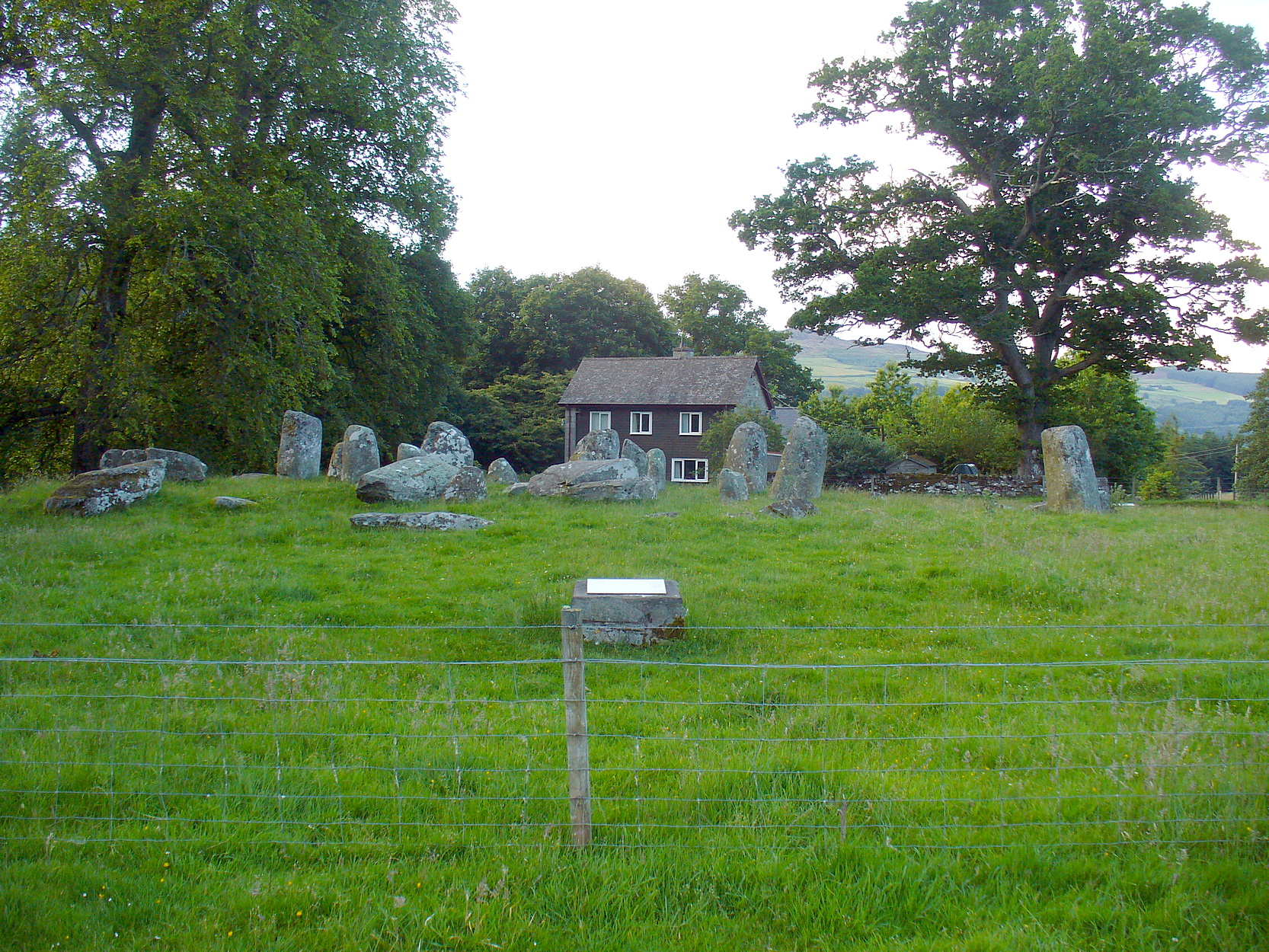
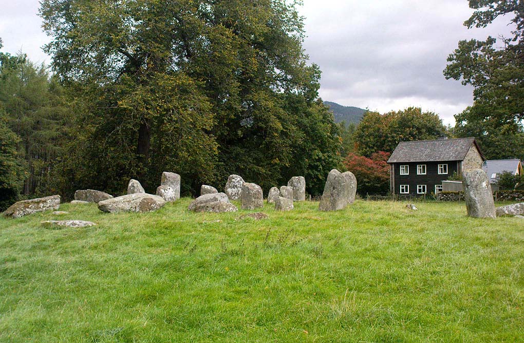
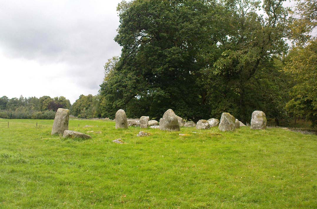
Take the A827 road that runs from Kenmore (top-end of Loch Tay) to Aberfeldy, and about 2 miles outside Kenmore, once you come out of the woodland (past the hidden standing stones of Newhall Bridge) and the fields begin on the east-side of the road, a small dirt-track leads you slightly uphill to the farm and house of Croftmoraig. The stone circle is right in front of the house less than 100 yards up the track (you can see it from the road).
Archaeology & History
A truly fascinating site, whose history is much richer than its mere appearance suggests. It has mythic associations with both moon and sun, a cup-marked stone to the southwest, and an earlier structure that had Aubrey Burl (1979) suggesting was possibly “the dwelling-place of a priest, a witch-doctor, a shaman.” Not bad at all!
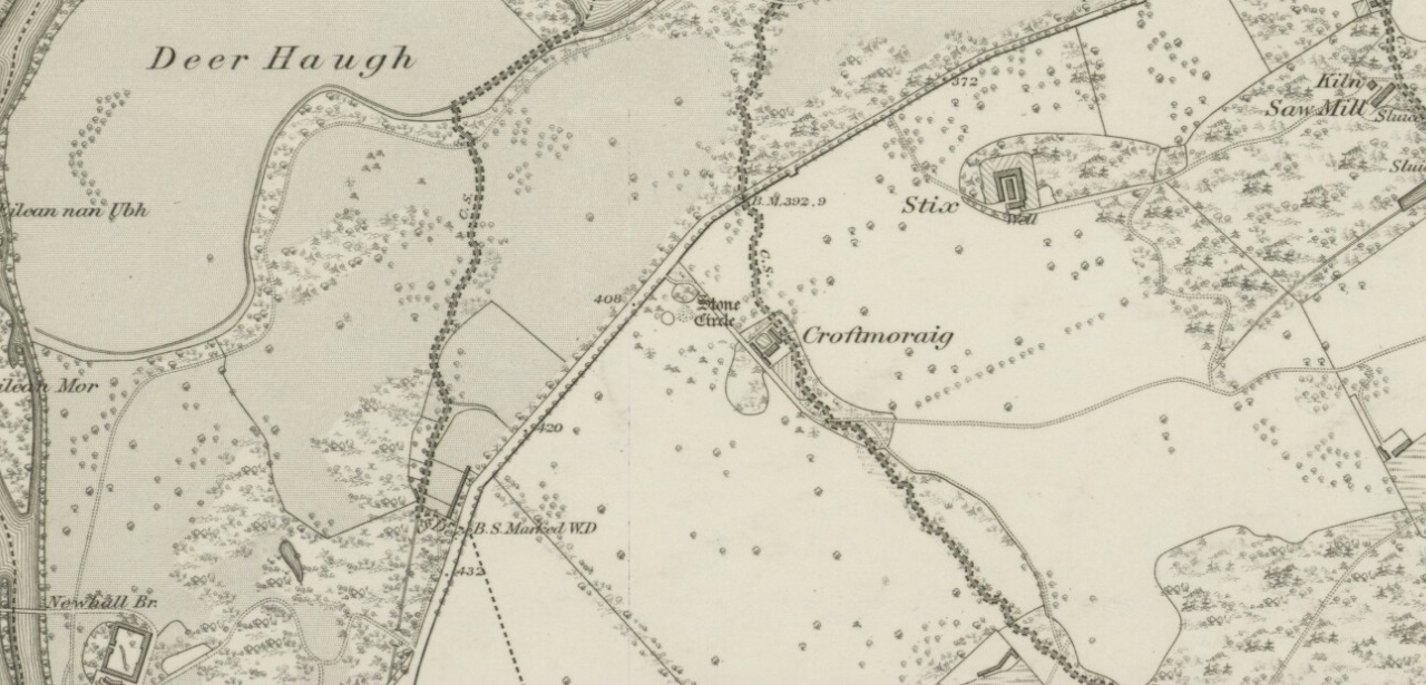
Croft Moraig on 1867 map
The sad thing today is its proximity to the increasingly noisy road to Aberfedly whose begoggled drivers care little for the spirit of place or stones. Here sits a feel of isolation and tranquility broken. But at least the cold information of its architecture is available for tourists and archaeologists alike; at least their depersonalized appreciations are served!
Described first of all (I think) in the old Statistical Account by Colin MacVean (1796), he told Croft Moraig to be one of “several druidical temples” in the area, “perhaps the largest and most entire of any in Scotland,” he thought:
“It is about 60 yards in circumference, and consists of three concentric circles. The stones in the outermost (ring) are not so large as those in the inner circles, and are not, like them, set on end.”
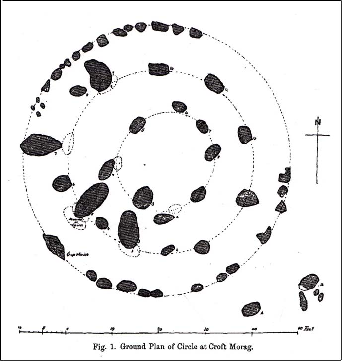
Hutcheson’s 1889 planCroft Moraig, looking N
The first decent archaeocentric evaluation of Croft Moraig was done in the 19th century by Alexander Hutcheson (1889), who gave us not only the first decent ground-plan of the site, but was also the first person to note that there were some faded cup-and-ring markings at the circle. After first directing his antiquarian readers to the site, he described the multiple rings of stones here, that had been built on top of an artificial platform of earth and stones:
“The circles are concentric, three in number, and occupy a little plateau which may be artificial, as the outer circle just covers it, on the gentle slope which here rises towards the south from the public road.
“I have prepared and exhibit a plan of the circles, and for reference have distinguished the stones by numbering them in the plan. The inner circle consists of eight stones all standing, with one exception, No. 3, which presumably has fallen inwards. The next or second circle consists of thirteen much larger stones, nine of which stand erect; Nos. 3 and 5 have presumably fallen in, while Nos. 7 and 9 have fallen outwards. The outer circle is formed by a number of smaller stones placed so as to form a sort of rampart. These are recumbent, and lie generally with their larger axes in the direction of the rampart. The circle measures, over the stones, as follows:
“Inner circle, West to East, 25 ft. 6 ins., North to South, 22 ft. 6 ins.
“Second circle, West to East, 40 ft North to South, 41ft 3in
“Outer circle, West to East, 58 ft North to South, 58ft
The stones are all rounded or water-worn boulders of dolerite, granite, schist, &c. The stones marked A and B are large blocks, 6 feet 6 inches high, 4 feet broad, and 2 feet 6 inches thick, standing upright. C seems to be a large (section) which has fallen from B, and lies flat on the ground.
“At the south-west side and in the line of the outer circle lies the cupmarked stone… If, as has been suggested, the two large blocks A and B formed the entrance to the circles, then the entrance faced towards the south-east. The blocks vary in height from 3 feet to 7 feet above ground, while of those which I have supposed to have fallen, their dimensions are, naturally from the ground-hold having to be added, much greater, amounting in one of them to 9 feet 6 inches long. There is a longish low mound of small stones, like an elongated cairn, which might yield something if it were to be searched. It lies just abreast of the cup-marked stone. I have referred to the recumbent stones in the two inner circles as having probably stood at one time erect. This I have presumed for several reasons, the principal being that one end of each of these stones corresponds in position with the circle formed by the standing stones; and while this is the case the recumbent stones do not preserve a uniformity of direction, but lie indifferently outwards and inwards from the lines of circularity, and at differing angles from these lines…”
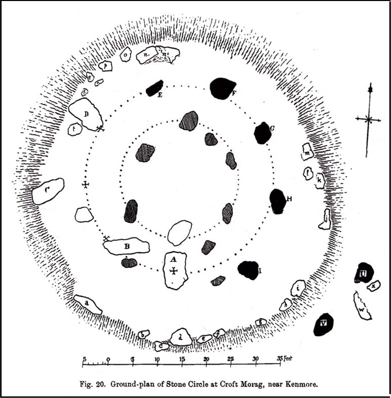
Fred Coles’ site planOne of the cup-marked stones
Some twenty years later, the legendary northern antiquarian Fred Coles (1910) brought his lucidity to Croft Moraig and with it, even greater attention to detail. In a lengthy description of each and every aspect of the circle that has yet to be equalled he gave the reader the most detailed description we have. I hope you’ll forgive me adding Mr Coles’ prolonged description, but it is most valuable for anyone wanting to explore the site in greater detail. He wrote:
“As will be seen from the plan…the structural portion of Croft Morag consists, first, of a roughly circular, earthen mound (lettered in small type a-t), some 3 feet high, which is marked off by several stones of a more or less slab-like character, set irregularly upon a circumference of, approximately, 185 feet. This outermost setting, or revetment of stones is visible now only at certain fragments of the arcs; i.e., it is well-defined on the SW at a, where a long Stone, 6 feet 5 inches by 2 feet lies flat, and bears numerous cup-marks…; on the S arc there are five small Stones (b, c, d, e, f) all earthfast and flattish; on the SE are three similar Stones (g, h, i); on the E arc, four (j, k, l, m); on the N arc, very slightly to the west, one very large Stone (n) flush with the ground at the edge of the bank and a good deal overgrown with grass, measuring 8 feet 6 inches by 3 feet 3 inches; farther to the NW are five stones more (o, p, q, r, s), the last three having only very small portions visible; and, still farther round, is the last of what I consider to be these ridge-slabs (t) close under the edge of the great fallen sloping stone D. Thus the total number of measurable and separate stones now resting on the outermost ring is twenty.
“The stones of the intermediate ring constitute the imposing feature of the circle. They are thirteen in total number in the present condition of the circle, but they probably numbered eighteen when the circle was complete. Nine of them are the tallest in the whole group; four of these are prostrate on the W arc. By striking a radius from the common centre of the circle through the centres of these great stones which are erect, to the outermost circumference, the following measures are obtained: from centre of E, the NNW stone, to the ridge 14 feet 6 inches; from F, NNE stone to the ridge 13 feet 4 inches; from G to ridge 14 feet 4 inches; from H to ridge 13 feet 4 inches; and from I, the SE stone, only 10 feet 6 inches. The four fallen blocks, lying as shown A, B, C, D, no doubt stood on this intermediate ring, the diameter of which measured from centre to centre is 38 feet. Now, it must be observed that between A and B and A and I there are Stones (shaded in the plan); these two are erect, the one near B measuring 3 feet in length, 2 feet in breadth, and 3 feet 4 inches in height; it is quite vertical, and is undoubtedly in situ. The other small erect Stone midway between A and I has much the same size’ and features. Between B and C there is shown in outline another of these small stones ‘in line’ with the great pillars which remain on the E arc; and it is quite clear that if this remarkable and novel feature of alternating each tall stone with a very small but vertical block was originally carried out all round this intermediate ring, there would have been eighteen stones in all. Without the most arduous and careful excavation in these interspaces however, it would be extremely difficult, if not impossible, to prove that these small blocks did once stand on the eastern semicircle.
“As illustrating the general size of the great stones, when fully exposed to view, the dimensions of the four fallen blocks are here given: A, 7 feet 7 inches by 4 feet 10 inches, and fully 2 feet thick; B, 9 feet 2 inches by 3 feet 9 inches (on the upper face), and 2 feet 9 inches thick; C, 8 feet by 4 feet, and 3 feet fi inches thick; D, 7 feet by 4 feet 6 inches, and 3 feet thick at its vertical outer edge.
“The five upright stones of the intermediate ring measure as follows: I, the SE stone, 5 feet 6 inches in height, and in girth 11 feet; H, the east stone, 5 feet 8 inches in height, pyramidal in contour, and in girth 11 feet 4 inches; G, the NE stone, 5 feet 3 inches in height and 11 feet in girth; the next stone, F, 5 feet 7½ inches in height and 13 feet 6 inches in girth; and stone E, nearest to the north on the W arc, stands 6 feet 3 inches in height and measures round the base 9 feet 3 inches.
“The stones forming the inner ring, which is a broad oval in form, are eight in number, quite erect, with one exception; the fallen one (shown in outline) is due south of one set at the north point and the distance between these two is 23 feet 8 inches. If however, the distance between the N Stone and the E one at the SSE be taken, this diameter is 26 feet, as against one of 21 feet taken between the NW and SE stones. Measured from the centre of the fallen stone a space of 10 feet 3 inches divides that from the centre of the erect stone on the east, and an equal space divides it from the centre of the stone on the west. Between the N stone and that on its southwest an equal space of 11 feet 3 inches exists as between that stone and its SE stone; but between these last two there is a third almost exactly midway. The fallen stone measures 5 feet 10 inches by 3 feet 9 inches; the NW stone is 4 feet 6 inches in height, the SW stone 3 feet 6 inches, the N stone 3 feet 4 inches, the NE one 2 feet 6 inches, and the stone between it and the fallen block 3 feet 4 inches in height.
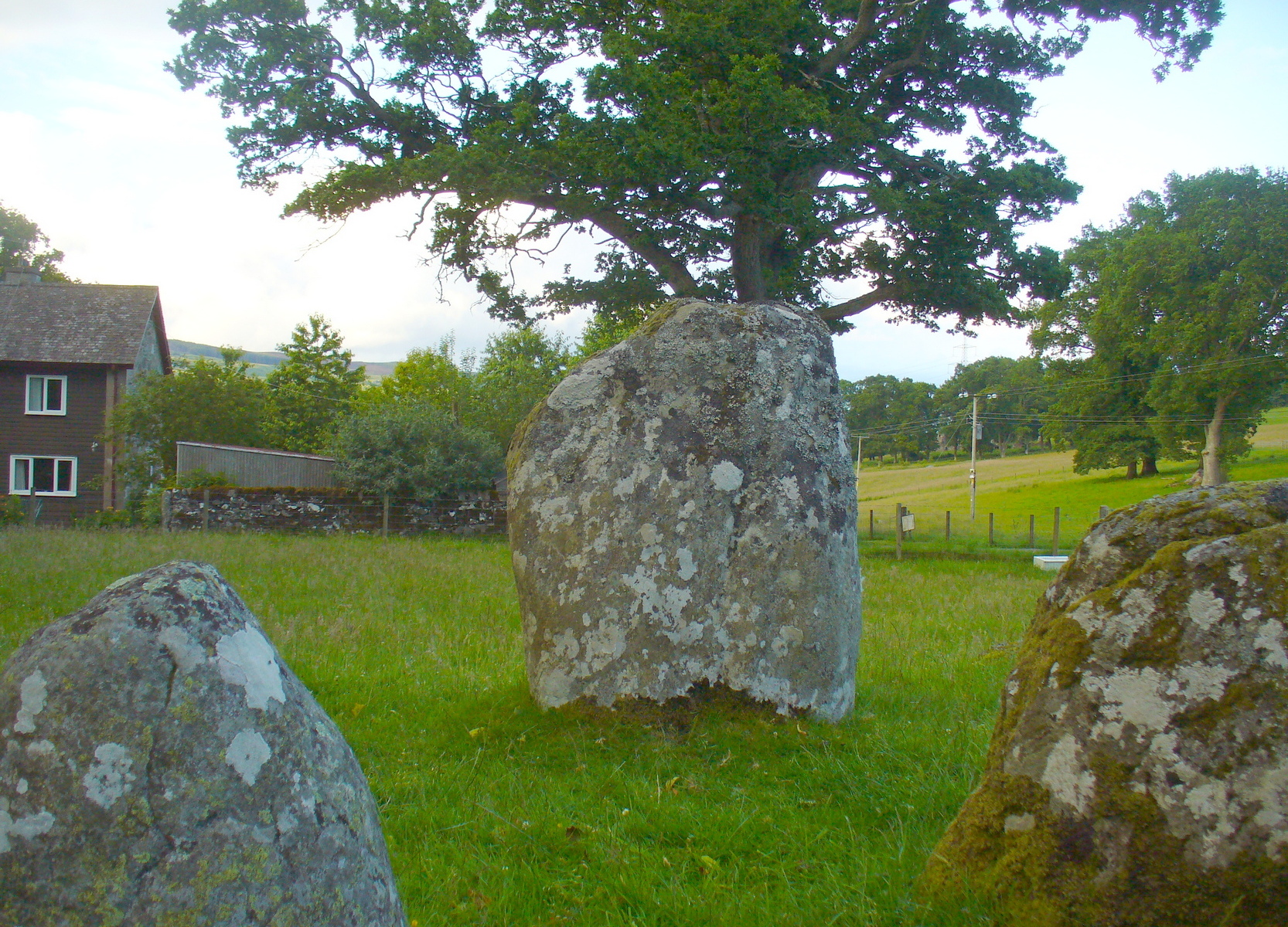
“In addition to the feature above noticed, of tall stones alternating with much smaller ones, Croft Morag possesses another noticeable arrangement in the presence of two great massive monoliths (U and V on the plan) standing like the remains of a portal, nearly eight feet outside of the boundary ridge on the SE. Neither of these stones is now absolutely vertical, stone U leaning considerably out towards the SE, and V having a very slight lean inwards to the circle. The former is 6 feet 2 inches in vertical height with a basal girth of nearly 12 feet, which is probably an under-estimate, for there are two large fragments (w and x) which appear to have been severed from this stone, the edges of which nearest the fragments are rough and sharp. The latter (V) stands 6 feet 4 inches in height and girths 11 feet 8 inches…
“…Besides its complexity of arrangement and the great number of measurable stones, forty-two in all, this circle is emphasised by the existence of a cup-marked stone set in a portion of its structure…on the SW arc… There are nineteen cups in all, only two of which differ much in diameter and depth from the rest, and there does not appear to be anything in their design to suggest a meaning or lend a clue to their symbolism.”
When the monument was excavated by Stuart Piggott and his mates in 1965, it was found to have been built over many centuries. As Aubrey Burl told:
“The first phase, of the late neolithic, consisted of about 14 heavy posts arranged in a horseshoe shape about 25ft 10in x 22ft 10in (7.9 x 7m) with a natural boulder at its centre. Burnt bone was found near this. Outside was a surrounding ditch and at the E was an entrance composed of 2 short rows of posts.
“In the second phase the timbers were replaced by 8 stones graded in height towards the SSW, also erected in a horseshoe 29ft 10 x 21ft (9.1 x 6.4m). A rubble bank was heaped up around it. On it at the SSW was a prostate stone with over 20 cupmarks carved on it. Other cupmarks were ground into the NE stone.
“Finally a circle of 12 stones, about 40ft (12.2m) is diameter, was erected around the megalithic horseshoe with a pair of stones forming an entrance at the ESE. Graves may have been dug at their bases later.”
Fred Coles mentioned a couple of other local names given to the site, one of which – Mary’s Croft – he thought may point “to a dedication to the Virgin.” Another curious place-name next to the site is called Styx,
“which appears to be the modern abbreviated form of the Gaelic word stuicnean. This, Mr Dugald McEwan affirms, meant ground full of overturned forest-trees; and it is therefore probable that in the remote past all the land surrounding the Stone Circle was a deep forest, and perhaps because of its seclusion, this site was selected as the most fitting for the erection of the principal Circle of the district.”
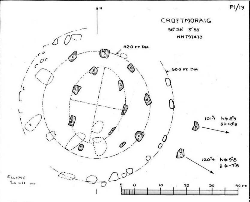
Alex Thom’s ground-plan
When the engineer and archaeoastronomer Alexander Thom (1967) came to examine Croft Moraig, he found the outlying stones to the southeast could have been solar alignment indicators, albeit poor ones. However, the geometric structure of the ring appeared to further confirm the use of his Megalithic Yard by those who built the circle. Thom’s illustration shows his finding, which he described briefly as follows:
“Two concentric circle and an ellipse. The circle diameters drawn are obviously too large and could be as small as 58.5ft outer circle and 41.0ft inner. Outer circle diameter58.5ft = 21.5 MY. Perimeter 67.5 MY = 27 MR. Inner circle diameter 41.0ft = 15.1 MY. Perimeter 47.3 MY = 18.9 MR. Ellipse drawn has major axis 11 MY, minor axis 8 MY, distance between foci is 7.5 MY. Perimeter is 30.0 MY = 12 MR. This ellipse looks slightly large but the triangle on which it is based and the perimeter are almost perfect.”
Folklore
Old lore told that the standing stones of Newhall Bridge 850 yards away (777m) were once connected with the Croft Moraig circle. William Gillies (1938) told this tradition saying,
“that at one time there was a paved way connecting the circle, of which these stones are the remains, with the great Croftmoraig circle.”
Croft Moraig, looking W
Fred Coles also noted that one of the stones in the circle (stone D in his plan) had “been polished by the sliding of generations of children”. This playful action on stones elsewhere in the UK and around the world sometimes relates to fertility rites (i.e., the spirit of the stone could imbue increased fertility upon the practitioner), but Coles made no mention of such rituals here.
References:
Burl, Aubrey, Rings of Stone, Frances Lincoln: London 1979.
Burl, Aubrey, The Stone Circles of Britain, Ireland and Brittany, Yale University Press 2000.
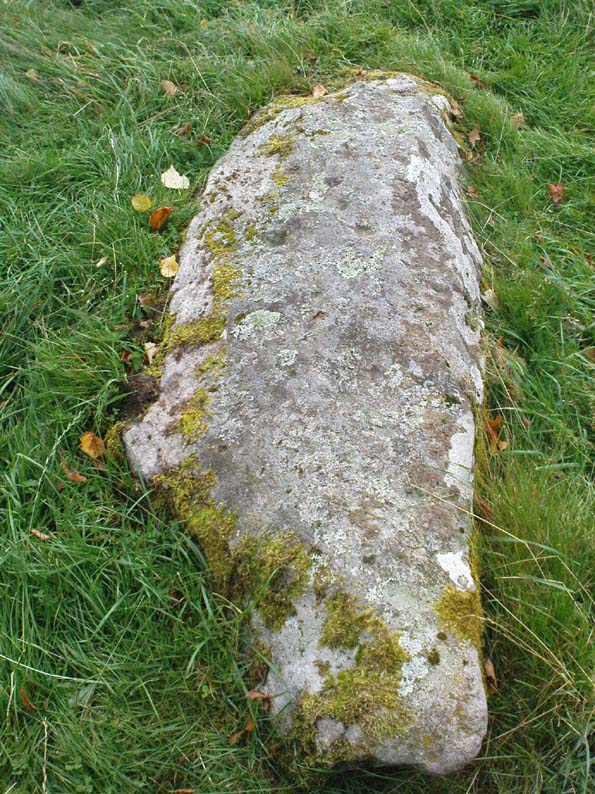
Follow the same directions for the Croft Moraig stone Circle. Then check out the elongated stone lying in the grass on the southern edge of the circle. It’s not that hard to find!
Archaeology & History
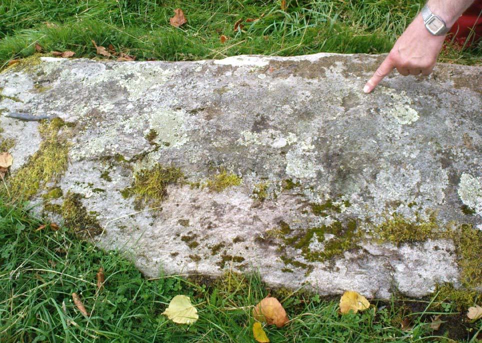
Nearly 13 yards (11.75m) south of the faded Croft Moraig 2 carving, this cup-and-ring stone on the SSW edge of Croft Moraig is one of at least four that have been found in this megalithic ring. It has been suggested that the stone on which the carving is found once stood upright. The earliest account I’ve found of it comes from Alex Hutcheson’s (1889) essay in which he wrote:
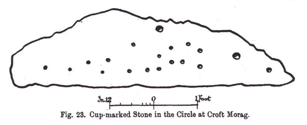
“At the south-west side and in the line of the outer circle lies the cupmarked stone. It is a recumbent stone, and like the others in that circle lies with its larger axis in the direction of the encircling line. It measures 6 feet 6 inches long by 2 feet broad, and bears on its surface 23 cups. Two of these are connected by straight channels. The largest cup is 2 inches in ‘diameter and f inch deep. Two of the cups are encircled, each with a concentric ring. None of the other stones exhibit any cups or other artificial markings.”
Cup-marks pointed outFred Coles 1910 drawing
…Although other cup-marks have subsequently been found on other stones within the circle. Consistent with the location of cup-and-ring marks elsewhere in the country, Hutcheson found the carved rock to be just in front of “a longish low mound of small stones, like an elongated cairn, which might yield something if it were to be searched.” Very little of this cairn remains today.
When Fred Coles (1910) came to explore Croft Moraig about 20 years later, he could only discern 19 cups on the stone, most of them the same size, “only two of which differ much in diameter and depth from the rest.” The cup-and-ring that Hutcheson described and the other missing cups had been overgrown by the grasses, Coles said. When Sonia Yellowlees described the carving in 2004, she said that 21 cups were visible, “one of which is surrounded by a single ring”—which you can clearly see in the photos below.
Carving 1 with cup-and-ringClose-up of design
When archaeologist Evan Hadingham (1974) looked at this site, he found deposits of quartz here and thought that their presence may have been relevant to the placement of the carving, noting how such a relationship is found at other circles in Scotland. In more recent years, rock art students Richard Bradley and others have found similar quartz deposits in or around some petroglyphs a few miles from here; as have fellow students Jones, Freedman and o’ Connor (2011) at some of the rock art around Kilmartin. In my own explorations of the carvings near Stag Cottage, hundreds of quartz chippings were found that had been pecked into the cups and rings.
References:
Burl, Aubrey, Rings of Stone, Frances Lincoln: London 1979.
The standing stone that could once be seen here is long gone. Its existence was reported in John Stuart’s (1854) short essay on stone circles of the region, in which he told:
“On the summit of the Hill of Balnoon, or rather on its neck towards the east, there was till lately a lofty upright stone called The Conwath or Conway Stone, and by some The Charter Stone. It was surrounded by a slight ditch.”
A recumbent stone in the field immediately north may relate to Stuart’s old report.
Folklore
In the same article, Mr Stuart told some interesting folklore which strongly implies the stone to have had importance for women. He said:
“It has been said that funerals coming from the west end of the parish were accompanied to this stone by the females of the family, and that the funeral here rested for a time, and the females returned (the stone being in sight of the churchyard). My informant (the minister of the parish) states, that a cairn on the hill of Auchinhamper was used for a similar purpose by funerals coming from the east end of the parish. On visiting the stone, however, I found that the churchyard was not visible from that spot.”
We know very little about the site that once stood here — even Aubrey Burl (2000) found no history here. It seems that antiquarian records were never made in this outlying district and even folklore records seem to have missed this region! (surely not?) A. Lindsay Mitchell (1992) told that the circle here had been built into the church, but knew no more.
First described in the old Statistical Account of Scotland in 1794, even then it was in the past tense, as they said that “a Druidical temple is said to have stood in the vicinity of Balkethly. Not the smallest vestige can now be seen.” Balkaithly Farm is a few hundred yards east of Dunino. In the New Statistical Account of the region in 1845 it was reported that three stones close to the west wall of the minister’s garden at Dunino were said to be part of the ruined circle. The site had truly gone. By 1925 when the Royal Commission (1933) lads visited the place to look for any remains, they told:
“The stone circle which formerly existed near the church at Dunino has now been entirely destroyed, but what are believed to be portions of some of the original stones are built into the dyke on the north side of the roadway at the south-west of the churchyard, about 100 yards east of its junction with the main thoroughfare to St. Andrews.”
A few hundred yards west of the circle, “a short cist containing a fine food-vessel urn was accidentally discovered during ploughing on the farm of Beley.” This was sent to Edinburgh’s National Museum.
Folklore
Locally, there are several places alleged to have been the actual spot where the circle once stood. Several stones within nearby Dunino church have typical Mason marks carved on them which, local folklore says, identifies them as coming from the circle and then subsequently being built into the church. Also in the churchyard is a small carved upright stone, which local people visit and leave offerings upon.
References:
Batchelor, Richard A., Origin of St. Andrews: Moon, Magicians and Maidens in Fife, Shieling: St. Andrews 1997.
Burl, Aubrey, The Stone Circles of Britain, Ireland and Brittany, Yale University Press 2000.
The site is usually invisible, being under the waters of Walshaw Dean Middle Reservoir. But in good droughts you can catch a glimpse of the place. So take the Widdop road as it’s known locally, from either Hebden Bridge up past Heptonstall, or from Burnley, Nelson & Colne side, and park-up by the pub a few hundred yards east of Widdop Reservoir. Walk a few hundred yards back down the road (east) and take the dirt-track on the other side of the road on the Calder-Aire link leading to the Pennine Way. Walk up past the first reservoir, keeping to its west-side, until you reach the Lodge house where the second lake appears. Now, if the water’s down, walk along its western-edge for about 50 yards, looking into the dried flat ahead of you and you’ll see the loose ring of small stones. That’s it! Or as Mr Roth described the place in 1906, “The position of the circle is on the left-hand side of the valley going up, a few yards above the dam of the second reservoir.”
Archaeology & History
Earliest photo of the circle
This is a somewhat bizarre archaeological site, whose nature we may never fully recover. Although listed and scheduled as a plain stone circle by Aubrey Burl (2000) and others, both the placement and structure of the site implies a more funerary aspect to it. This was suggested by Ling Roth (1906) when he first wrote about it. But for me, the position of the site in the landscape calls into question the archetypal ‘stone circle’ category, as it is somewhat hemmed-in both east and west, with limited views north, and only a good view of open lands to the south (summer). It’s just a bit odd when compared to other megalithic rings in the Pennines. But perhaps this ‘privacy’ was intended — as there is only scattered evidence of other human activity in this valley and on the moors above. Perhaps this site was meant to be ‘cut off’ from the rest of the world. We might never know…
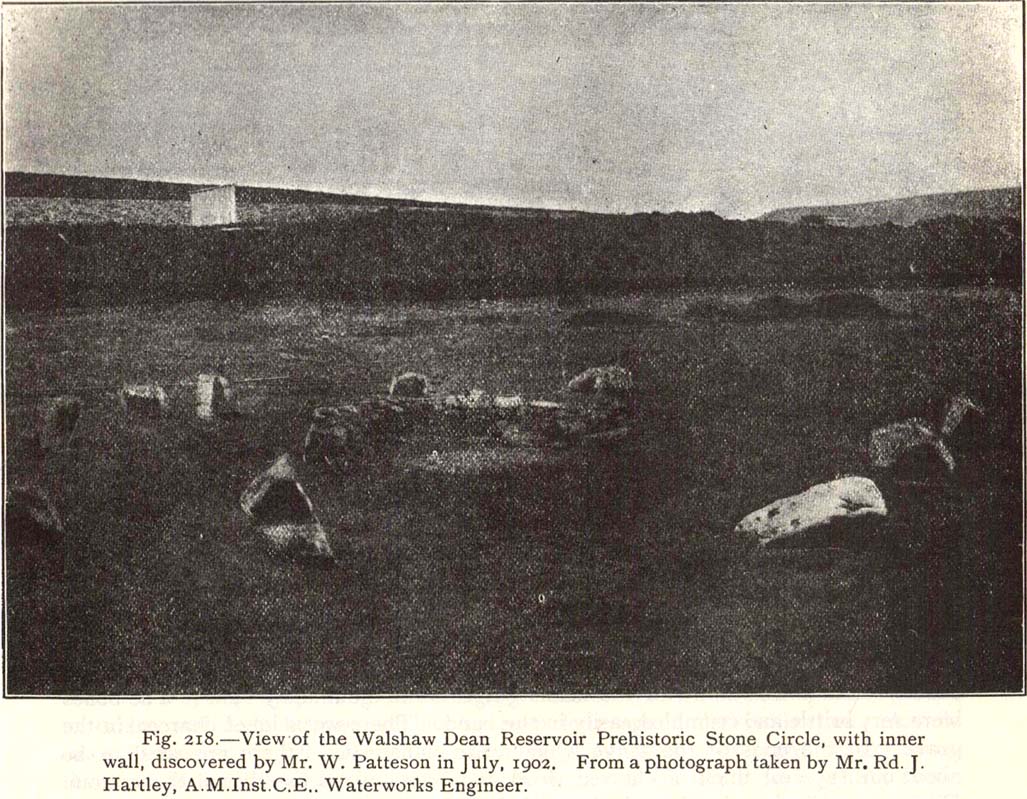
There is also the peculiar addition inside this stone circle of an arc of walling facing southeast, which is unique in this part of Britain. But this walling seems to have been a later addition and has the hallmarks of being some small shelter, or even an early grouse-shooting butt (there’s tons of game-birds here, and this would be an excellent spot to shoot from) This internal wall may have been constructed from stone that came from the circle itself: perhaps in a rubble wall, perhaps an internal cairn. It seems likely. Mr H. Ling Roth (1906) also mentions this feature in what was the first description of the site, where he told:
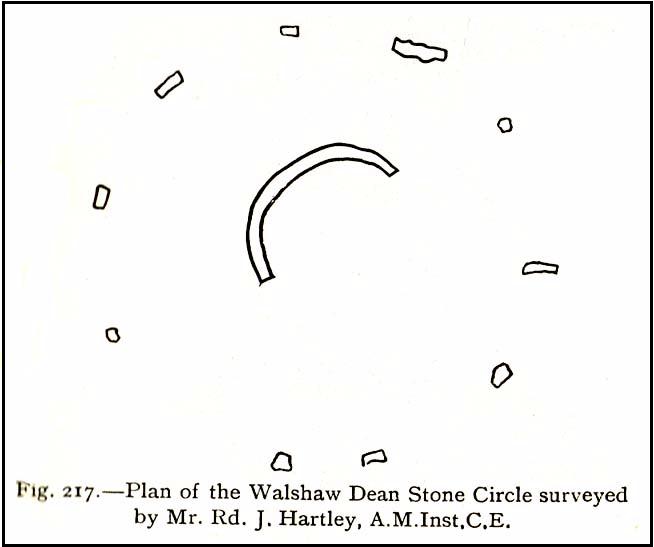
“The stone circle at Walshaw Dean Reservoir…was discovered by Mr W. Patteson, the resident engineer, in July 1902. The circle consists of ten irregular stones apparently local rock, varying considerably in size, one measured 6ft 3in (1.9m) long and stood about 30 inches (76cm) above the clay when the peat surface was removed. Whether the stones are deeply embedded has not been ascertained, but where they were covered by the peat a clear white band is apparent. The circle is 36 feet (11 metres) is diameter and of very fair exactitude. Inside the circle as shewn on the plan and in the view there was a rouhg carved wall which measured across the ends 12ft (3.7m). The wall had been partly pulled down and reset immediately before examination by a party of visitors soon after the discovery. Its presence in the circle may be fortuitous, but after the two unsystematic disturbances to which the ground had been subjected, it is not possible to form an opinion about it. That something had been buried in the centre of the circle is probable when we bear in mind the circumstances of stone circles elsewhere, but an examination shewed only that the ground had been disturbed and Mr Patteson explained to me that such disturbance was not of recent date.”
To my knowledge, no subsequent excavation of the site has ever been done, but it would appear that the waters have washed part of the site away and any remains that may once have been found within the ring have been discarded by more than a century of erosion. Traces of small walled structures have also been noted close to the circle in recent years, suggestive of settlement remains. On a TNA outing last year, we also found previously unrecorded prehistoric remains on this hills above here. When Geoffrey Watson (1952) wrote his survey on prehistoric Calderdale, he suggested that the Walshaw Circle may have been placed alongside the branch of an early trade route running along the northern edge of the valley. Not so sure misself…
References:
Bennett, Paul, The Old Stones of Elmet, Capall Bann: Milverton 2001.
Burl, Aubrey, The Stone Circles of Britain, Ireland and Brittany, Yale University Press 2000.
Roth, H. Ling, The Yorkshire Coiners, 1767-1783; and Notes on Old and Prehistoric Halifax, F.King: Halifax 1906.
Watson, Geoffrey G., Early Man in the Halifax District, HSS: Halifax 1952.
At the pub by the bridge which crosses the Falls of Dochart (aptly called the ‘Falls of Dochart Inn’), walk downstream following the dirt-track which runs parallel with a section of the river for a good 5-600 yards. In the field that appears on your right, watch out for the rise of the stones as you approach the large gates which take you into the ground of Kinnell House. You can climb over the gate just into the field and go straight to the stones.
Archaeology & History
Found on the field called Kinnell Park in the grounds of Kinnell House, less than a mile out of Killin, this is a well-preserved site consisting of six stones. It appears to have been described first of all by Thomas Pennant in 1772, in the same breath as the megalithic remains at Lawers on the other side of Loch Tay. Pennant wrote:
“In going through Laurs observe a Druidical circle; less complete indeed than one, that should have been mentioned before, at Kinnel, a little southwest of Killin; which consists of six vast stones, placed equidistant from each other.”
Coles’ 1910 plan of KinnellThom’s geometric plan
It would seem that the site has changed little since Pennant’s visit. Sitting on a reasonably level grassy plain, the hills rise and surround the small ring of stones, with the lower horizons running along the south. Due west (equinox) we have the large pyramidal hill of Meall Clachach; whilst to the north are the legendary hills of Creag na Cailleach and Ben Lawers, each with their own rich mythic archaeological legacies. Legendary stones and wells are also close by, some with rites still enacted by old local people keeping truly ancient traditions alive.
The first detailed archaeological survey of the Kinnell site was done by Fred Coles and published in 1910. It has yet to be superseded. Mr Coles wrote:
“Taking the Stones in the usual order…I here give their dimensions and characteristics: Stone A, 6 feet 3 inches high, springs from an oblong base which girths 11 feet 4 inches, to a rough irregular top; Stone B leans forward towards the centre of the Circle, and measures along its sloping back 6 feet 9 inches, the present height from the ground to its upper edge being 4 feet. It is of smooth garnetiferous schist, and free from the deep fissures and rifts so common in these Stones. Stone C, a very rectangular but narrow block of schist, has a 15 Feet-girth at the base of 9 feet, but tapers up from both ends to a pyramidal summit, 5 feet 4 inches above ground. Its inner face is over 6 feet in breadth. Stone D, 4 feet 6 inches high, is a broad, flat-topped, very massive block, measuring 9 feet 5 inches round the base, but near the middle of its height 11 feet 2 inches. Stone E, the shortest of the group, is only 4 feet high, has a rough, uneven top, and a basal girth of 8 feet 11 inches. Stone F, the tallest, measures 6 feet 4 inches in height, but in girth only 7 feet 3 inches. It is very rough, vertically fissured in many places, and full of white quartz veins.
“Neat, well-defined, and comparatively small as this Circle is, it is to be noticed that the positions of the Stones do not conform to perfect regularity as points on the circumference. On working out the plan, the measurements prove that a diameter of 29 feet exactly bisects three of the erect Stones, B, C, and F, but leaves the other two untouched. The interspaces of the settings are not all quite equal, a space of 14 feet 8 inches dividing the centres respectively of F and A, A and B, F and E, and E and T); but between D and C it is 13 feet 8 inches, and between 0 and B I S feet 5 inches. Yet, the Stones stand proportionally near enough to each other to give one a satisfying impression that these six megaliths represent the group in its completeness, and that there were no smaller blocks between any two of them. The space enclosed by these stones is quite smooth and level, bearing no indication of having at any time been disturbed.”
Many years later, the late great Alexander Thom came here and, with his geometric perspective, gave a more precise ground-plan and lay-out. Thom (1980) defined the site as a “Type B flattened circle, or possible ellipse,” with a perimeter of 35 megalithic yards and diameter of 11.8 MY. Aubrey Burl’s commentary described Kinnell as:
“Six stones of schist stand evenly spaced on the circumference of an ellipse 32ft 7in x 27ft 5in (9.9 x 8.4m) in diameter. The stones are graded in height towards the SW where the two tallest are over 6ft (1.8m) high.”
One of the upright stones was said by Hugh MacMillan (1884) to have had cup-markings on it in the 19th century, when he told of the circle possessing “some seven or eight tall massive stones, with a few faint cup-marks on one of them.” But these appear to have faded, or were cut into the one of the missing stones.
Folklore
Close to the Kinnell circle could once be found a curious large boulder, covered in moss, but with a large cavity in which water gathered. Local lore ascribed the rock to actually be a well, as it was known as ‘The Well of the Whooping-Cough’, or Fuaran na Druidh Chasad, measuring some eight feet long and five feet high. Local people visited the site to be cured of the said disease, but Hugh MacMillan also suggested that the miraculous well-in-the-stone was connected with ancient rituals once enacted at the Kinnell circle, saying:
” it is a reasonable supposition that the Fountain of the Whooping-Cough may have had some connection in ancient times with this prehistoric structure in its immediate neighbourhood…”
He may have been right!
References:
Burl, Aubrey, A Guide to the Stone Circles of Britain, Ireland and Brittany, New Haven & London 1995.
Pennant, Thomas, A Tour in Scotland, 1772 – Part 2, Benjamin White: London 1776.
Royal Commission on the Ancient & Historical Monuments of Scotland, Archaeological Sites and Monuments of Stirling District, Central Region, Society of Antiquaries of Scotland 1979.
Thom, A., Thom, A.S. & Burl, H.A.W., Megalithic Rings, BAR: Oxford 1980.
Wheater, Hilary, Killin to Glencoe, Appin Publications: Aberfeldy 1982.
From Shieldaig, take the A896 road east to Torridon and Kinlochewe (a bloody superb part of Scotland – perhaps the best!) for a couple of miles, round the stunning bay of Ob Mheallaidh, till you reach the tiny hamlet of Balgie. From here, walk upstream following the small River Balgie until you hit Loch Damh. At the edge of the rugged and boggy flatland shortly before the loch itself, amble about in the rushes on your right (west). You’ll find it!
Archaeology & History
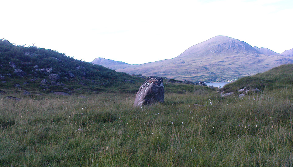
This is a small but chunky standing stone was rediscovered by Dr J. Havelock Fidler in the 1980s. Less than four-feet tall, it stands alone at the edge of the boggy landscape, with superb views all around (the hill in the background photo is An Ruadh-mheallan). There are other human remains scattered amidst the rocky landscape close by, including the remains of old buildings not far away, but this prehistoric monolith seems to be an isolated example. However, the landscape here is so vast that it’s highly likely that other standing stones remain hidden in these ancient mythic hills…
References:
Fidler, J. Havelock, Earth Energies, Aquarian: Wellingborough 1988.
Follow the directions to reach Churn Milk Joan, the head 100 yards east till reaching the crossing of footpaths, beneath Crow Hill. Take the northern (left) route and keep walking. Half a mile along you’ll see the tall upright stone to your left. You can’t really miss it!
Archaeology & History
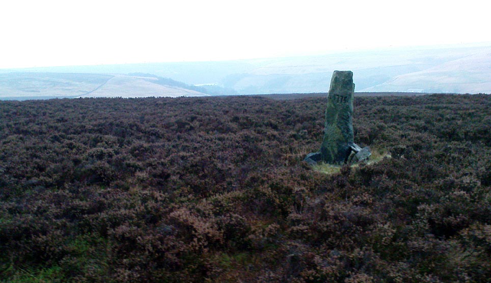
The Greenwood Stone is an old boundary stone and is not prehistoric. It stands more than four feet tall. I first visited the site in 1988 in the company of several folklore and antiquarian writers, including Andy Roberts, Edna Whelan and Graeme Chappell. Twas a good day and coincided with a small collection of Psilocybes being gathered!
The tall upright is a boundary stone that was erected in 1775, as evidenced by the date carved on its southern face. I must emphasize however that this was not when the stone came to acquire its name: this was defined in 1594 as evidenced by a boundary perambulation written that year where it is described as being recumbent: “thence to one lying stone, newly named Greenwood Stone.” About 10-15 yards away is what may have been that very “lying stone,” the original Greenwood Stone, half-buried in the heather some six or seven feet long. It is possible this may have stood upright in the distant past.
Greenwood Stone, looking south
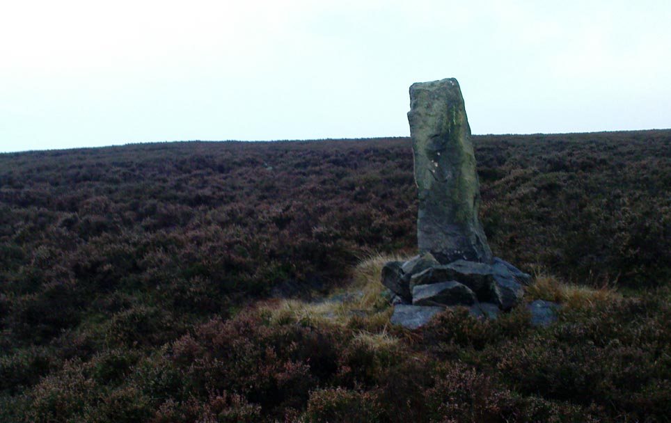
Moving about 75 yards south we come across another small standing stone at 1360 feet (412m) above sea level. This I’ve called the ‘Greenwood B stone’. It was marked on an old map as a boundary stone and is distinctly shaped to stand upright, marking a point separating the moors of Midgley and Wadsworth. When stood upright it is just visible on the horizon when looking from the Miller’s Grave prehistoric tomb several hundred yards east of here and is close to being an equinox indicator.
References:
Bennett, Paul, The Old Stones of Elmet, Capall Bann: Milverton 2001.
Bittova journey this — but well worth it! From Broughton-in-Furness take the A595 road west, past Duddon Bridge for about another 1½ miles, turning right up the small single-track country lane beloved of city-mind drivers, up the fertile scruffy road, past Broadgate and stopping just before Cragg Hall Farm. There’s a dirt-track running up the back of Cragg Hall. Go up here and keep walking for a mile or so until, as you approach Swinside Farm and the fields open up in front of you, the stones begin to appear.
Archaeology & History
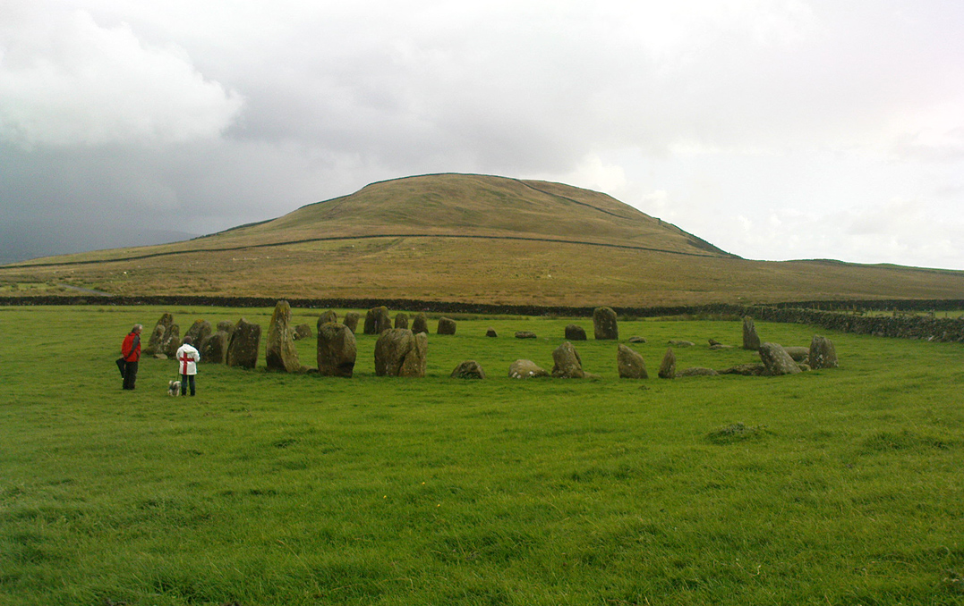
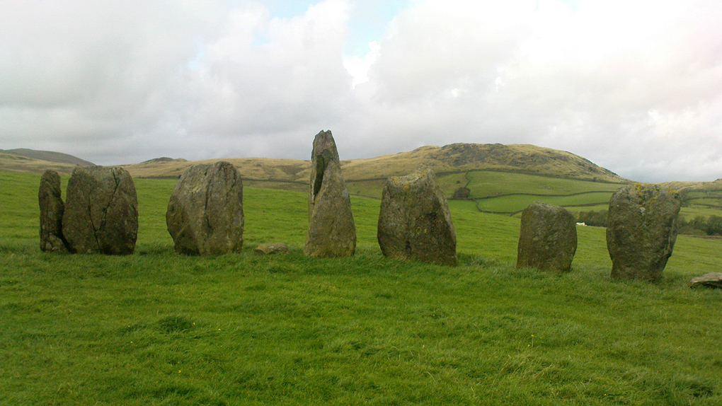
Swinside, looking east
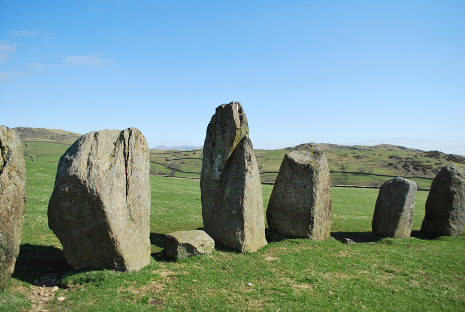
The Swinside stone circle is Aubrey Burl’s favourite. And for good reason! Like other impressive megalithic rings of the region, the stones are large, well set, and the landscape holds the stones finely in the hills. Without the landscape here, Swinside (like Castlerigg and elsewhere) would not have such grandeur. When you sit in the ring, or walk round it, Knott Hill to the south was of obvious mythic relevance to the people who built this stone circle four or five thousand years ago. But this can be said of many of the surrounding crags. A few miles southwest we see the top of the haunted Black Combe rising into clouds, still speaking to some with spirits from animistic realms, long known to our ancestors. Following the skyline west and past the small falls of Whicham stream, whose name speaks of long past trees, we reach the near-west skyline with the cairn-looking pap of the Raven Crag, symptomatic of magickal rites calling to and beyond the circle. To the north is the symbolic ridge of Lath Rigg. Along the craggy eastern ridges from here you get the impression that you’re more in Argyll than Cumbria; and the break in the hills to the southeast reaches to the distant pinnacle of Kirkby Moor, where the midwinter sunrise emerged to tell of solar calendrical motions and the coming of the dark season to our megalithic tribes. But enough of the landscape!
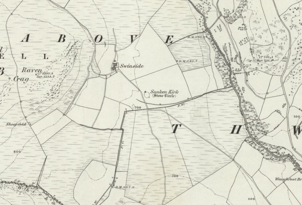
Swinside on 1867 OS-map
Although the name Swinside can be traced back to the 13th century, the local folk-name of the circle—Sunken Kirk—was mentioned for the first time as “the Chapell Suke” in Parish Registers of 1624. No earlier literary source has yet been identified, probably because of the isolation of the site and the lack of people writing about the area. Swinside stone circle is, just about, a perfect circle, give or take a foot here and there, holding the circular dome of the heavens within its domain. Yet despite its almost regal appearance, early references to the site seem scant. It seems to have been first described in William Hutchinson’s huge History of Cumberland (1794), where he told:
“In the neighbourhood of Millum, at a place called Swinside, in the estate of William Lewthwaite Esq., of Whitehaven, is a small but beautiful druidical monument; it is circular, about twenty eight yards in diameter; the stones of which it is composed are from six to eight feet high, all standing and complete. A little to the south, is another of larger dimensions, but not in so perfect a state: the neighbouring people call those places by the emphatical names of Sunken Kirks.”
A few years later, William Camden’s legendary text Britannia was edited and reprinted again, this time by Richard Gough (1806), who told:
“At Swineshead, a very high hill…is a druidical temple, which the country folk call Sunken Kirk, i.e., a church sunk into the Earth. It is nearly a circle of very large stones, pretty entire. No situation could be more agreeable to the Druids than this; mountains almost encircle it, not a tree is to be seen in the neighbourhood, nor a house, except a shepherd’s cot at the foot of a mountain surrounded by a few barren pastures. At the entrance are four large stones, two placed on each side at the distance of six feet. The largest on the left hand side is five feet six inches in height, and ten feet in circumference. Through this you enter into a circular area, 29 yards by 30. This entrance is nearly southeast. On the north or right-hand side is a huge stone of conical form, in height nearly nine feet. Opposite the entrance is another large stone which has once been erect, but is now fallen within the area: its length is eight feet. The left hand or southwest is one, in height seven feet, in circumference 11 feet nine inches. The altar probably stood in the middle, as there are some stones still to be seen, though sunk deep in the earth. The circle is nearly complete, except on the western side some stones are wanting. The largest stones are about thirty one or two in number. The outwards part of the circle upon the sloping ground is surrounded with a buttress or rude pavement of smaller stones raised about half a yard from the surface of the Earth… This monument of antiquity, when viewed within the circle, strikes you with astonishment, how the massy stones could be placed in such regular order either by human strength or mechanical power.”
Tall, northernmost stone to centreNortheast section of the ring
It seems he was impressed! Yet despite this, in the 19th century not many folk strayed this far into the western edges of Lakeland to look upon Swinside. There were occasional descriptions from travellers and antiquarians such as J.T. Blight (1843) and Edwin Waugh (1861), each speaking of the site’s visual magnitude, but it wasn’t until archaeologist C.W. Dymond came here, first in 1872 and then again in 1877, that a fuller account of the site came into being. In his essay on a “Group of Cumberland Megaliths,” he said how the stones were still in excellent condition and that,
“few of the stones seem to have been removed — probably because plenty of material for walling and road-making could be collected from the neighbouring hillside.” (Dymond 1881)
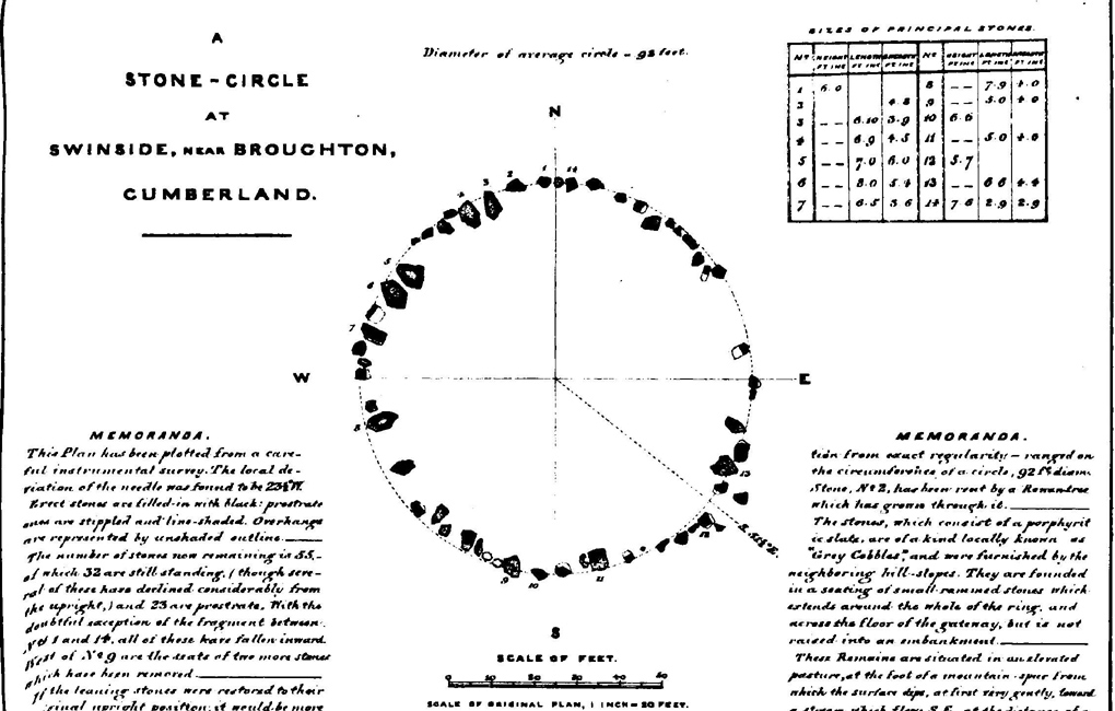
When Mr Dymond first came here he told of the remains of a rowan tree which had split one of the stones, but this has long gone. More than twenty years after the archaeologist’s first visit, he returned with R.G. Collingwood to make a more detailed evaluation of the ring. He measured and planned Swinside like it had never been done before and his ground-plan (below) is still very accurate indeed. Aubrey Burl (1999) takes up the story:
“The ring was partly excavated by Dymond, Collingwood and three men from midday Tuesday, 26 March 1901, until the close of the following evening. They dug two long, intersecting 46cm-wide trenches, NW-SE, NE-SW, across the ring with a curious zigzagging pattern of others between southeast and southwest: an investigation of some 51m² of the central area. Within the circle the trenches represented less than a thirteenth of the 642m² of the interior.
“Below the grass and turf was a thin layer of soil under which yellowish marl or ‘pinnel’ varied from 15cm to 75cm in depth, being deepest at the entrance which had been dug into earlier around 1850. Wherever it was uncovered the gravelly marl was wavily uneven, presumably the result of ploughing. The bases of the circle-stones rested on the pinnel, held firmly in their holes by small cobbles with others heavily packed around the sides. The only finds were a nut-sized lump of charcoal just northeast of the centre with others near the entrance; a minute splinter of decayed bone near the first bit of charcoal and two pieces of red stone. There were also some contemporary glass sherds and a Lancaster halfpenny dated between 1789 and 1794 lying in the uppermost turf layer.”
Dymond’s 1881 plan of Swinside
Since these early archaeological digs, Swinside has given up little else. Much like other stone circles in the British Isles, few real clues as to exactly what went on here have been forthcoming. But in the 1960s, investigations into megalithic sites made a bit of a quantum leap and some old ideas about astronomical ingredients were resurrected.
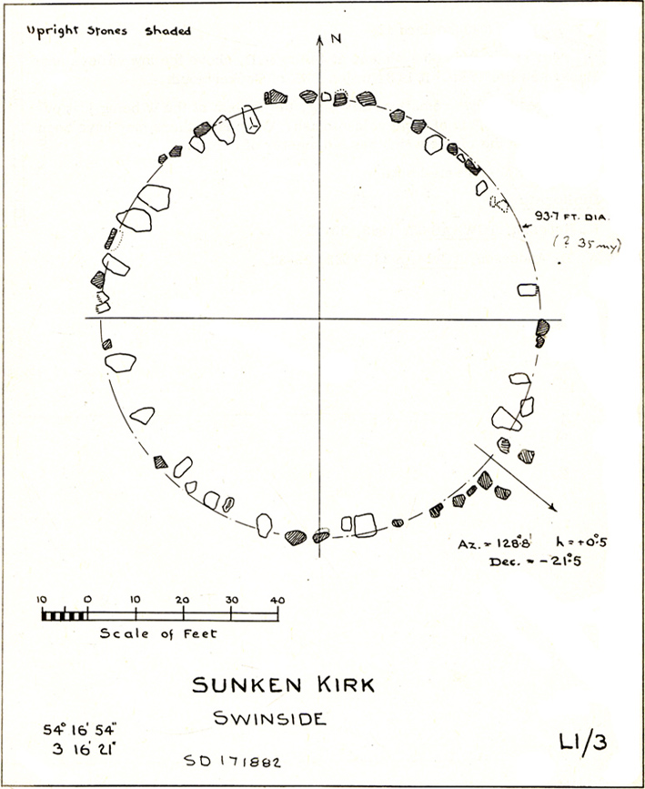
Alexander Thom’s plan of Swinside
Swinside was one of the places explored by engineer and megalith enthusiast, Alexander Thom. Thom was one of the prime figures instrumental in the resurgence of interest in megalithic sites — and his finds of megalithic astronomy and prehistoric mathematics had a lot to do with it. Although we know today that some of Thom’s work isn’t correct, his explorations and research stand him far ahead of most archaeologists who pretended to represent this area of research. He left us with the most detailed ground-plans of megalithic sites to date and, of course, showed some fascinating alignments.
Thom listed Swinside as site “L1/3” and made the most detailed and accurate ground-plan of this and 18 other megalithic rings in Cumbria. He found it to be 94 feet in diameter, with an internal area measuring 6940 square feet. The one major alignment Thom found at Swinside was of the winter solstice sunrise, lining up just on the edge of the ‘entrance’ to the circle’s southeastern side.
Folklore
Like a number of other stone circles, folklore told that you couldn’t count the stones. Janet and Colin Bord (1997) also told that people once tried to build a church here in early christian days, but once the builders went home in the evening, the Devil pulled down what they’d built during the day. A motif found at Ilkley’s Hanging Stones cup-and-ring carvings and many other prehistoric sacred sites in the country.
References:
Armstrong, A.M. et al., The Place-Names of Cumberland – volume 2, Cambridge University Press 1950.
Bord, Janet & Colin, Prehistoric Britain from the Air, Weidenfeld & Nicolson: London 1999.
Burl, Aubrey, “‘Without Sharp North…’ – Alexander Thom and the Great Stone Circle of Cumbria”, in Ruggles, Clive, Records in Stone, Cambridge University Press, 1988.
Burl, Aubrey, A Guide to the Stone Circles of Britain, Ireland and Brittany, New Haven & London 1995.
Burl, Aubrey, Great Stone Circles, Yale University Press: New York & London 1999.
Burl, Aubrey, The Stone Circles of Britain, Ireland and Brittany, Yale University Press 2000.
Dymond, C.W., “A Group of Cumberland Megaliths,” in Transactions of the Cumberland and Westmorland Antiquarian and Archaeological Society, volume 5, 1881.
Dymond, C.W., “An exploration at the Megalithic Circle called Sunken Kirk at Swinside, in the Parish of Millom, Cumberland,” in Transactions of the Cumberland and Westmorland Antiquarian and Archaeological Society, New Series volume 2, 1902.
Gough, Richard (ed.), Camden’s Britannia, J. Nichols and Son: London 1806.
Hutchinson, William, The History of the County of Cumberland – volume 1, F. Jollie: Carlisle 1794.
Seton, Ray, The Reason for the Stone Circles in Cumbria, R. Seton: Morecambe 1995.
Thom, Alexander, Megalithic Sites in Britain, Oxford University Press 1967.
Thom, A., Thom, A.S. & Burl, H.A.W., Megalithic Rings, BAR: Oxford 1980.
Waterhouse, John, The Stone Circles of Cumbria, Phillimore: Chichester 1985.
Waugh, Edwin, Seaside Lakes and Mountains of Cumberland, Alexander Ireland: Manchester 1861.
ACKNOWLEDGEMENTS:
Huge thanks to Brian Else for his photos. And to Paul and Tricia for taking us here, in awesome downpour weather!