The great Yorkshire historian Harry Speight (1892) gave the directions for this place, which I’ve not located. On his walk down the southern side off Whernside, he told us to “follow the road which runs between Gunnerfleet and the white house at Winterscales, going under the long viaduct and round by Batty Wife Hole onto the main road at Ribblehead….” About 100 yards or so down the road, look over the walling into the field on the left-hand side. It’s there…..somewhere!
Archaeology & History
In an area that is pretty rich in prehistoric sites, one of our great Yorkshire antiquarians, Harry Speight (1892) seems to have described a site which our archaeologists have yet to get round to finding. He told that,
“nearer the wall there are indications of a rude, double circle, artificially formed of these dark weathered grits. The inner circle is about 20 yards in diameter and the outer one forms a narrow aisle surrounding it, with an outlet to the north; but some of the stones have been removed, probably to build and repair the adjoining fences. The situation is open and commands the country on all sides between the lofty moors and summits that hem in the dale-head. On the opposite side of the road are the remains of a couple of large cairns. They are presumably Danish. One was opened about a century ago (c.1790), and found to cover a rude stone coffin containing an entire human skeleton. The other large pile does not ever appear to have been examined. It is more than probable that many a furious battel has been waged here, as the possession of this prominent ridge, which dominates so many particular outlets, must have been of capital importance to every hostile tribe.”
Although the Victorian christian beliefs of ‘rudeness’ in everything and rampant hostile tribes, has long since subsided in the view of our ancestors. This area described by Speight does sound like an old burial ground. But from which age – and where now are the sites he described?
References:
Speight, Harry, The Craven and Northwest Yorkshire Highlands, Elliot Stock: London 1892.
The site is usually invisible, being under the waters of Walshaw Dean Middle Reservoir. But in good droughts you can catch a glimpse of the place. So take the Widdop road as it’s known locally, from either Hebden Bridge up past Heptonstall, or from Burnley, Nelson & Colne side, and park-up by the pub a few hundred yards east of Widdop Reservoir. Walk a few hundred yards back down the road (east) and take the dirt-track on the other side of the road on the Calder-Aire link leading to the Pennine Way. Walk up past the first reservoir, keeping to its west-side, until you reach the Lodge house where the second lake appears. Now, if the water’s down, walk along its western-edge for about 50 yards, looking into the dried flat ahead of you and you’ll see the loose ring of small stones. That’s it! Or as Mr Roth described the place in 1906, “The position of the circle is on the left-hand side of the valley going up, a few yards above the dam of the second reservoir.”
Archaeology & History
Earliest photo of the circle
This is a somewhat bizarre archaeological site, whose nature we may never fully recover. Although listed and scheduled as a plain stone circle by Aubrey Burl (2000) and others, both the placement and structure of the site implies a more funerary aspect to it. This was suggested by Ling Roth (1906) when he first wrote about it. But for me, the position of the site in the landscape calls into question the archetypal ‘stone circle’ category, as it is somewhat hemmed-in both east and west, with limited views north, and only a good view of open lands to the south (summer). It’s just a bit odd when compared to other megalithic rings in the Pennines. But perhaps this ‘privacy’ was intended — as there is only scattered evidence of other human activity in this valley and on the moors above. Perhaps this site was meant to be ‘cut off’ from the rest of the world. We might never know…
There is also the peculiar addition inside this stone circle of an arc of walling facing southeast, which is unique in this part of Britain. But this walling seems to have been a later addition and has the hallmarks of being some small shelter, or even an early grouse-shooting butt (there’s tons of game-birds here, and this would be an excellent spot to shoot from) This internal wall may have been constructed from stone that came from the circle itself: perhaps in a rubble wall, perhaps an internal cairn. It seems likely. Mr H. Ling Roth (1906) also mentions this feature in what was the first description of the site, where he told:
“The stone circle at Walshaw Dean Reservoir…was discovered by Mr W. Patteson, the resident engineer, in July 1902. The circle consists of ten irregular stones apparently local rock, varying considerably in size, one measured 6ft 3in (1.9m) long and stood about 30 inches (76cm) above the clay when the peat surface was removed. Whether the stones are deeply embedded has not been ascertained, but where they were covered by the peat a clear white band is apparent. The circle is 36 feet (11 metres) is diameter and of very fair exactitude. Inside the circle as shewn on the plan and in the view there was a rouhg carved wall which measured across the ends 12ft (3.7m). The wall had been partly pulled down and reset immediately before examination by a party of visitors soon after the discovery. Its presence in the circle may be fortuitous, but after the two unsystematic disturbances to which the ground had been subjected, it is not possible to form an opinion about it. That something had been buried in the centre of the circle is probable when we bear in mind the circumstances of stone circles elsewhere, but an examination shewed only that the ground had been disturbed and Mr Patteson explained to me that such disturbance was not of recent date.”
To my knowledge, no subsequent excavation of the site has ever been done, but it would appear that the waters have washed part of the site away and any remains that may once have been found within the ring have been discarded by more than a century of erosion. Traces of small walled structures have also been noted close to the circle in recent years, suggestive of settlement remains. On a TNA outing last year, we also found previously unrecorded prehistoric remains on this hills above here. When Geoffrey Watson (1952) wrote his survey on prehistoric Calderdale, he suggested that the Walshaw Circle may have been placed alongside the branch of an early trade route running along the northern edge of the valley. Not so sure misself…
References:
Bennett, Paul, The Old Stones of Elmet, Capall Bann: Milverton 2001.
Burl, Aubrey, The Stone Circles of Britain, Ireland and Brittany, Yale University Press 2000.
Roth, H. Ling, The Yorkshire Coiners, 1767-1783; and Notes on Old and Prehistoric Halifax, F.King: Halifax 1906.
Watson, Geoffrey G., Early Man in the Halifax District, HSS: Halifax 1952.
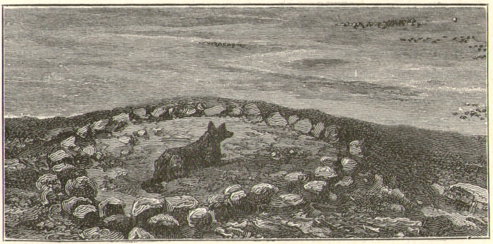
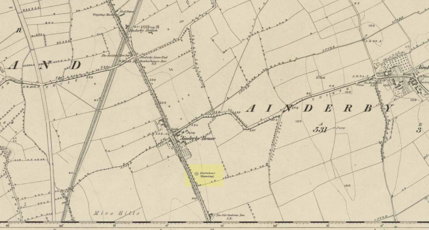
Long since destroyed by the self-righteous advance of the Industrialists, this was a pretty impressive-looking tomb according to the account of D.M. Waterman (1951). Found between the villages of Ainderby Quernhow and Kirklington, right at the side of an important prehistoric trackway—later used by the Romans and known as Leeming Street (on what is now the A1 motorway). Waterman cited it as being “of primary importance in prehistoric times” as it stood on the great plain between the three great henges of Thornborough to the north and those on Hutton Moor to the south, accompanied by a number of other tumuli nearby.
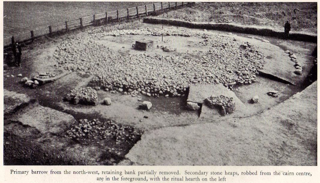
Quernhow tomb on 1856 OS mapThe excavated monument
When Waterman and his team arrived here, the barrow “appeared as a low-spread mound, about 3ft in elevation, the exact limits of which were difficult to define,” due to large parts of it being covered over in mud that’d been dumped there by the local land-owner, aswell as erosion due to other farming or industrial activity. But once the archaeologists had stripped the centuries of soil from the damaged surface of the monument, a most impressive site emerged! At the heart of this great burial mound was found “an imposing stone cairn, more or less flat-topped and with a circular constructed face.” He (1951) continued:
“The material of the cairn was composed of cobbles or boulders, all of local geological origin, ranging in size from a few inches up to a foot in diameter or more. A stone considerably larger in size was occasionally encountered , the largest found measuring 23in by 20in and from 3in to 5in in thickness. The stones were heaped up without any deliberate attempt at producing a stable structure and used indiscriminately, irrespective of size or shape, although there was a tendency for the larger stones to occur towards the perimeter of the cairn. Since the cairn itself was built to a flat surface, and the underlying barrow-mound assumed a saucer-shaped profile, the cobbles perforce increased in depth towards the cairn face; at the very centre they were laid one, occasionally two deep, at the face three or four deep, although irregular size and placing precluded any consistency whatsoever in the work. The standard of the building in fact differed considerably throughout the structure. On the northeast and northwest the facing-stones were quite carefully laid, standing to a height of 22in, the work becoming increasingly shoddy towards the south where the construction had so deteriorated that whole sections of the facing had fallen bodily away from the cairn mass, slipping down the tail of the underlying mound…”
Plan of Quernhow
In the middle of the large cairn were found four small pits and a number of small cremations in and around them. There were also found the usual broken remains of pottery, human bones, charcoal, foods vessels and burnt pieces of oak and other vegetation. Near the centre of the cairn was a curious “four poster” of upright stones, “about 1.4ft long and rather less in breadth and thickness (which) suggest, from consideration of their obviously deliberate and careful placing, some significant function in burial ritual.” The four corners of these stones were close to the cardinal points: north, south, east and west.
References:
Waterman, D.M., “Quernhow: A Food Vessel Barrow in Yorkshire,” in Antiquaries Journal, volume 31, 1951.
Various ways to get here, probably the easiest is by taking the A639 north from Bolton, up to Turton & Entwhistle Reservoir. Park up in the layby and walk onto the hills behind you (south), right near the very top. Look around!
Archaeology & History
A long article by Major Gilbert J. French — ‘The Stone Circles on Chetham’s Close’ — in one of our northern antiquarian journals of 1894, told us a great deal about the sad remains of this once proud circle. I have reproduced the main body of the article here (with minor editing), which I hope is of interest to local historians and archaeologists around Bolton:
Early drawing of this now-ruined site
From time immemorial the existence of a so-called Druidical circle upon the top of Chetham’s Close has been recognised, and at one time the monuments of this circle must have been very pronounced and prominent. Within the last quarter of a century, however, the stones have been sadly mutilated and in part destroyed. This was chiefly done by the tenant farmer of the late owner, Mr. James Kay, who objected to people visiting the situation. Mr. Kay was communicated with, but did little or nothing to prevent the mutilation. I am glad to say that the present owner has expressed his intention of faithfully restoring and protecting the circle, and by the aid of the plan taken in 1871 by Mr. Thomas Greenhalgh, of Thornydikes, near Bolton, will have little trouble in doing so.
Writing to me on August 9th, 1890, he says: “I have this afternoon spent some time on the site of the Druidical circle with Mr. Edmund Ashworth, and, with the assistance of Mr. Greenhalgh’s plan, we have clearly made out the position of the circle. I am glad to find there are sufficient stones and remains of stones to enable this to be done, and it seems that there are similar stones close at hand to complete the circle.”
By the courtesy of Mr. J. P. Earwaker, I have had placed in my hands an early description of the circle, published in 1829 (August 11th) in the first volume of the Cambrian Society, and contributed by a writer who signs himself ‘Elvaeliad.’ He says:
“In the parish of Bolton-le- Moors is a hill named Turton Heights, and on the south-east end of it is a large sheep pasture, which goes by the name of Chetham’s Close. Nearly on the summit of this close, but inclining to the north-east, are the remains of a bardic temple, the diameter of which is about seventeen yards. There are only six stones of the circle remaining, and these are sorely mutilated either by time or the hand of man. The circle is as perfect as if traced by the compasses of Newton or La Place; and, what is rather singular, an upright stone stands about thirty-seven yards nearly east from its outward verge and another about seventeen yards due south. The ‘maen gorsedd’ has disappeared as well as some other stones forming the circle, and, from the oozy nature of the ground, I am inclined to believe that independent of the mutilations mentioned, the surface of the earth has risen considerably since the circle was first constructed. The views to the north and east are very fine, but bounded by hills rising and swelling above each other. Towards the south and south-east are seen Bolton and Manchester, with their busy populations; a considerable part of fertile Cheshire, Mow Hill in Staffordshire, and lofty ranges of mountains both in Derbyshire and Yorkshire; and were it not for Edgar¹ or Winter Hill on the west Penmaenmawr frowning upon the sea, Moel y Vammeau, and the bicapitated head of Snowdon would be distinctly visible on a clear day.
“Frequently have I visited this interesting spot, and, amidst the silence and solitude which reign there, thought of ‘the days of former years.’ Here have the bards in their different orders often met and performed their various rites and mysteries, with their uni-coloured robes flowing before the breeze. Here have hundreds, probably thousands, standing without the circle observed the solemn proceedings, and listened with deep attention to the maxims and doctrines which philosophers and Druids delivered. Since those periods, what changes, what revolutions have taken place! How often has the blue lightning flashed and the thunder rolled over this sacred spot! Kingdoms have risen and fallen, emperors have been throned and dethroned, arts and sciences have retrograded and advanced, and various and awful occurrences have taken place; but these rude stones, though severely shattered, still remain as attestations of the religious and philosophical views of the ancient Briton. But where are the founders of this monument and those who worshipped there ? The sages who often proclaimed within this circle,
‘Y gwir yn erbyn y byd,’ are gone the way of all flesh. “Our fathers, where are they? The prophets, do they live for ever?”
“About a mile and a half from this bardic temple a neighbour and friend of mine, whilst digging a drain, about twenty years ago (1819), discovered the head of an old British standard, which is now in my possession. It is of copper, the head of which is shaped like an axe, and the other end has a double groove in which the flagstaff entered, and, by that means, became firmly fixed. Its weight is fourteen ounces and a half, but was evidently heavier when perfect, as the ring on its side through which the cord of the flag ran is broken off, and the lower end of the groove has been also mutilated. Its figure, though not an exact one, may be seen in Gough’s edition of Camden’s Britannia, vol. ii., p. 501, pi. xviii., figure 13. From traces still remaining it is evident that a Roman road passed within two hundred yards where this relic was found. Now, my opinion is that the Romans and Britons met there in hostile array, and with their flags unfurled; that in the action which took place the Roman soldiers, for soldiers are ever the same, dashed at the British flag and cut it down, and that, owing to the tumult, the confusion, and the boggy nature of the ground, the standard head was broken off, sunk into the earth, and was lost.” (This account was then signed ‘Elvaeliad’, August 11th, 1829.)
Thus ends this chronicler, and his testimony is useful as corroborating that of subsequent generations.
In 1871 Mr. Thomas Greenhalgh, of Thornydikes, Bolton, prepared the following account of the circle, which was read before the British Archaeological Association, on June I4th of that year, and is published in the twenty-seventh volume of the transactions of that society:
“The township of Turton, like many others in southwest Lancashire, is largely occupied by lofty moorland hills the home of the grouse and the lapwing. Amongst these wilds is a range of high ground standing more distinct from the other moors than is usual with hills of this nature. The range is divided into two parts by a slight depression. That portion to the north is named Turton Heights, and is stated by the Ordnance Survey to be one thousand one hundred feet above the sea. The southern half is known as Chetham Close, from its having been the property of that old Lancashire worthy, Humphrey Chetham. This part is twenty-five feet lower than Turton Heights, and the depression spoken of above sinks about thirty feet lower still. The summit of each is a sort of table-land, sloping gently towards the depression just named, and extending both together about a mile from north to south by a quarter of a mile from east to west.
“Nearly in the centre of the northerly slope of Chetham Close and at an elevation of one thousand and sixty feet stand several stones of a Druidical circle. This circle, I should judge, originally consisted of eleven stones. Of these seven are still standing in a more or less perfect state. The diameter of the circle is small, being only fifty-one feet six inches. So the stones are, as might be expected, small likewise. The tallest is fifty-five inches by eighteen inches wide, and the shortest (number four) eight inches only in height. At the distance of forty-five feet, south-west from the outside of the circle, stands a solitary stone, nineteen inches high by ten inches wide, and southsouth-east at a distance of one hundred and two feet another stone, thirty-five inches high by seventeen inches wide. The stones vary in thickness from nine inches to fifteen inches.
“The position of the stones is circular, with vacant spots, and their dimensions and shapes vary. The table-land gradually rises from the circle in a southsouth-east direction and a short distance past the outlying stone a height of one thousand and seventy-five feet is attained, and a quarter of a mile further on a view is to be got, with a clear atmosphere, which towards the south is bounded only by the powers of vision. From this spot the ancient people who erected the circle must have often gazed on a scene which persons now familiar with south Lancashire would find it impossible to realise. The valleys and even the sides of the hills were clothed with trees, the oak and birch predominating, whilst the margins of the numerous streams and swamps were overhung by the alder; the wild boar and doubtless the wolf roamed in the woods, and smaller game abounded in the more open parts. The numerous waters throughout the district would be alive with fish, amongst which the salmon might be numbered; for when the country was better wooded and entirely uncultivated the large rainfall of the district (now about a mean of fifty-five inches) would be still more copious, and keep the streams full of water.
“The last few centuries have, however, wrought a wonderful change in the scene, which has been the most rapid since the introduction of machinery into the country; and from the same spot may now be seen the habitations, comprised in towns, villages, and farmhouses, of hundreds of thousands of human beings. Unfortunately, however, there are still to be found amongst us persons as barbarous in some respects as the rude people who erected the circle. These were rude in their ideas of building; the others barbarous in wantonly destroying that which time had made more interesting than the palaces of kings. Up to the spring of last year the circle appeared to have suffered little for ages; but at that time rambling over the moors I turned aside to take another look at the circle. Not that I thought of anything having happened, but for old acquaintance sake; when to my surprise I noticed a framework of wood within the circle, and upon reaching the spot itself what my disgust and astonishment were may be easily imagined, when I found two of the stones broken almost to fragments, and several others damaged. This could only have been effected by the aid of a heavy hammer, as the stories broken were before strong and sound. Fortunately, they were not rooted up so their places are still seen in the group. One very small one has apparently been in the state it now is for a long time.
“I at once communicated my unpleasant discovery to the owner of the land, James Kay, Esq., of Turton Tower, who instituted an enquiry, and traced it to some members of a picnic party, who had made use of the ground without asking leave. A few more such wanton pieces of mischief, and this interesting relic, like many others of its class, will be irrecoverably destroyed.
“About a mile from the circle, north-west from it and on a much lower level, eight hundred and ninety feet above the sea, is a flat piece of bog, called ‘Charter’s Moss.’ Here was found, about 1810, a bronze British celt. It was discovered by a man whilst digging turf, as I am told, at four feet from the surface. Having taken a careful drawing of it, I found, upon comparing it with similar objects in the British Museum, that in cases Nos.13 to 20, ‘British Antiquities Department,’ there were several closely resembling it, and one [No.315 Z] the all but exact representation of it. The Rev. Probert, in whose possession it had been for nearly half a century, and who resided a few hundred yards from the spot where it was dug up, died recently (then 1871), and bequeathed it to New College,² Gordon Square, London.”
I have no doubt that the British celt referred to in this account by Mr. Greenhalgh is the same as that mentioned in the previous description by ‘Elvaeliad,’ and I conjecture that this is the nom de guerre of the same Rev. William Probert referred to, who was a literary man, and the author of Ancient Laws of Cambria (1823) and other works. I am glad to say that this celt was kindly given up by the authorities of Manchester New College, and has been placed in the Chadwick Museum, Bolton. It is also interesting to note that a similar specimen was found in a quarry on Cockey Moor, near Ainsworth, about three miles from and in view of the circle, by Dr. Denham, about 1839. It is still in the possession of his family.
Mr. Matthew Dawes, of Bolton, also wrote a description of the circle, which was read before the Historic Society, in 1852. He says: “I accompanied Sir Henry Dryden to visit these remains in 1850. At that time there remained six stones upright, varying in height from one foot six inches to four feet, and in thickness from eleven inches to two feet. Judging from the relative distances of those remaining three stones have been taken away. At one hundred and fifteen feet south-east from the circle is a single stone and at eighty-two feet south-west is another, and between these two stones is an assemblage of smaller stones only just appearing out of the boggy soil.”
It has long been supposed that this circle of upright stones was the only one on the site; indeed, the late Mr. Scholes, in his recently published History of Bolton (1892, p.11), says only one circle is known about Bolton.
The adjacent ‘cairn circle’, in 1894
In June of last year, in company with Mr. Thomas Hardcastle, I visited the site, and noticed what was evidently another circle. This we perceived from the stones cropping up in places and from the nature of the turf. I find that the same opinion was formed by a member of the Manchester Literary Club (the late Mr. E. Kirk), who, in a paper read before the club, in November, 1878, says: “There are two circles, the more northerly formed of large individual stones, set diadem or corona fashion, the other of smaller stones, as if it had been a walled enclosure with a pile in the centre.” This observation is quite correct, and a removal of the surface of the earth last June to a depth of three to six inches revealed a perfect stone-walled circle, as shown in the illustration. This circle is larger than the upright one, being exactly twenty-four yards across (the size of similar stone circles, ex. gr., the circle at Zennor, Cornwall). It lies to the south-west of the upright circle and is twenty yards from the outlying westerly stone of same, and is twelve yards from the outlying southerly stone of same, and is on slightly higher ground than the first circle. The circle is faced on both inside and outside by large flat stones, and the space within is occupied by smaller stones. I can find no trace of mortar nor marks of tools, nor do I find any gateway or opening to the circle, although the whole of it has not yet been laid bare. The circling wall is of an average width or thickness of four feet. The stones are the ordinary grit stone of the district. The removal of part of the earth within the circle has shown a number of stones lying there and there is also a large collection in the exact centre. It is most symmetrically round, and the wall is very evenly and regularly constructed.
I think there is no doubt but that it is of later date than the upright circle and may have been subsequently used as a place of worship.
Possibly it may, in accordance with the theory of Dr. Colley March, have been a place for mortuary exposure before subsequent sepulture, and it is interesting to note that the Three Lowes in the valley below and about half a mile away are reputed Barrows. No bones or remains of any sort have yet been found, but so far only the upper surface lies exposed. Its situation and shape preclude the idea of its being a sheep-fold, and from its dimensions it is not likely to have been a watch tower or a “burgh.” Possibly it may be the site of a collection of ancient British dwellings, clustered together, and defended by the enclosing wall. The owner, Mr. Hardcastle, intends to make careful excavations, and from these some further information and enlightenment will probably be thrown upon the origin of what is undoubtedly a most interesting and important archaeological discovery.
Notes:
1. This is evidently the origin of the name of the adjacent township, “Egerton.” I have seen the place, “Edgar’s town,” marked in (fifteenth century) Lancashire maps.
2. Now the Manchester College, Oxford (Unitarian).
Get to the Twelve Apostles stone circle, then walk just 100 yards down the main footpath south, towards Bingley, and watch out for a small footpath immediately to your left. Walk on here and head for the rocky outcrop a half-mile ahead of you. Once past the outcrop, take the first footpath right and walk down for another 100 yards. Stop! – and walk into the heather. The circle’s about 50 yards away! You can of course come from the Menston side of the moor, following the same directions for the Great Skirtful of Stones, but keep walking on for another 200 yards, towards the rocky outcrop again, turning left down the path for 100 yards, before stopping and walking 50 yards into the heath again!
Archaeology & History
Roms Law circle
This is one of my favourite sites on these moors. I’m not 100% sure why – but there’s always been something a bit odd about the place. And I don’t quite know what I mean, exactly, when I say “odd.” There’s just something about it… But it’s probably just me. Though I assume that me sleeping rough here numerous times in the past might have summat to do with it, playing with the lizards, and of course…the sheep… AHEM!!! Soz about that – let’s just get back to what’s known about the place!
Grubstones is an intriguing place and, I recommend, recovers its original name of Roms or Rums Law. It was described as such in the earliest records and only seems to have acquired the title ‘Grubstones’ following the Ordnance Survey assessment in the 1850s. The name derives from two compound words, rum, ‘room, space, an open space, a clearing’; and hlaw, a ‘tumulus, or hill’ – literally meaning here the ‘clearing or place of the dead,’ or variations thereof. But an additional variant on the word law also needs consideration here, as it can also be used to mean a ‘moot or meeting place’; and considering that local folklore, aswell as local boundary records tell of this site being one of the gathering places, here is the distinct possibility of it possessing another meaning: literally, ‘a meeting place of the dead’, or variations on this theme.
The present title of Grubstones was a mistranslation of local dialect by the Ordnance Survey recorders, misconstruing the guttural speaking of Rum stones as ‘grub stones.’ If you wanna try it yourself, talk in old Yorkshire tone, then imagine some Oxford or London dood coming along and asking us the name of the ring of stones! It works – believe me….
The site has little visual appeal, almost always overgrown with heather, but its history is considerable for such a small and insignificant-looking site. First described in land records of 1273 CE, Roms Law was one of the sites listed in the local boundary perambulations records which was enacted each year on Rogation Day (movable feast day in Spring). However in 1733 there was a local boundary dispute which, despite the evidence of written history, proclaimed the Roms Law circle to be beyond the manor of Hawksworth, in which it had always resided. But the boundary was changed – and local people thenceforth made their way to the Great Skirtful of Stones on their annual ritual walk: a giant cairn several hundred yards east to which, archaeologically, there is some considerable relationship. For at the northern edge of the Roms Law circle is the denuded remnants of a prehistoric trackway in parts marked out with fallen standing stones and which leads to the very edge of the great cairn. This trackway or avenue, like that at Avebury (though not as big), consists of “male” and “female” stones and begins – as far as modern observations can tell – several hundred yards to the west, close to a peculiar morass of rocks and a seeming man-made embankment (which I can’t make head or tail of it!). From here it goes past Roms Law and continues east towards the Great Skirtful, until it veers slightly round the southern side of the huge old tomb, then keeps going eastwards again into the remnants of a prehistoric graveyard close by.
In my opinion, it is very likely that this trackway was an avenue along which our ancestors carried their dead. Equally probable, the Roms Law Circle was where the body of the deceased was rested, or a ritual of some form occurred, before taken on its way to wherever. It seems very probable that this avenue had a ceremonial aspect of some form attached to it. However, due to the lack of decent archaeological attention, this assertion is difficult to prove.
A previously unrecognised small single tomb is in evidence to the immediate southeast (5 yards) of the circle. There is also another previously unrecognised prehistoric trackway that runs up along the eastern side of the circle, roughly north-south, making its way here from Hawksworth Moor to the south. The old legend that Roms Law was a meeting place may relate to it being a site where the dead were rested, along with it being an important point along the old boundary line. Records tell us that the chant, “This is Rumbles Law” occurred here at the end of the perambulation – which, after the boundary change, was uttered at the Great Skirtful. This continued till at least 1901.
Northern section of the Ring
Modern archaeological analysis of the site is undecided as regards the actual nature of Roms Law. Ordnance Survey maps show it as an “enclosure” (which is vague); Faull & Moorhouse’s survey (1981) erroneously tell us it had no funerary nature, contrary to Eric Cowling’s (1946) report of finding bones and ashes from the small hole in near the centre of the ring, aswell as the 1880 drawing of the site in Collyer & Turner’s survey (above). And we find the single cairn on the south-eastern edge of the ring indicating burial rites of sorts definitely occurred here. Described variously by previous archaeologists as a stone circle, a ring cairn, cairn circle, an enclosure, aswell as “a rubble-fill wall of a circular house” (by some anonymous member of the West Yorkshire Archaeology Service, who didn’t respond to my queries about this curious assumption), the real nature of Roms Law leans more to a cairn circle site. A fine example of a cup-and-ring stone — the Comet Stone — was found very close to the circle, somewhere along the Grubstones Ridge more than a hundred years ago, and it may have had some relevance to Roms Law.
This denuded ring of stones is a place that has to be seen quite blatantly in a much wider context, with other outlying sites having considerable relationship to it. Simple as! (If you wanna know more about this, check out my short work, Roms Law, due out shortly!)
Describing the status and dimensions here, our great Yorkshire historian Arthur Raistrick (1929) told that:
“The larger stones still standing number about twenty, but the spaces between them are filled with stones of many intermediate sizes, so that one could with only considerable detail of size, etc, number the original peristalith.”
…Meaning that we’re unsure exactly how many stones stood in the ring when it was first built! Although a little wider, the Roms Law is similar in form to the newly discovered ‘Hazell Circle‘ not far from here. The site has changed little since Raistrick’s survey, though some halfwits nicked some of the stones on the southwestern edge of the site in the 1960s to build a stupid effing grouse-butt, from which to shoot the birds up here! (would the local council or local archaeologist have been consulted about such destruction by building the grouse-butt here? – anyone know?) Thankfully, this has all but disappeared and the moorland has taken it back to Earth.
There is still a lot more to be told of Roms Law and its relationship with a number of uncatalogued sites scattered hereby. Although it’s only a small scruffy-looking thing (a bit like misself!), its archaeology and mythic history is very rich indeed. “Watch This Space” – as they say!
Folklore
Alleged to be haunted, this site has been used by authentic ritual magickians in bygone years. It was described by Collyer & Turner (1885) “to have been a Council or Moot Assembly place” — and we find this confirmed to a great extent via the township perambulation records. Considerable evidence points to an early masonic group convening here in medieval times and we are certain from historical records that members of the legendary Grand Lodge of All England (said to be ordained in the tenth century by King Athelstan) met here, or at the adjacent Great Skirtful of Stones giant cairn 400 yards east.
The boundary perambulations which occurred here on Rogation Day relate to events just before or around Beltane, Mayday. Elizabeth Wright (1913) said of this date:
“These days are marked in the popular mind by the ancient and well-known custom of beating the parish bounds, whence arose the now obsolete name of Gang-days, and the name Rammalation-day, i.e., perambulation-day, for Rogation-Monday. The practice is also called Processioning and Possessioning… The reason why this perambulation of the parish boundaries takes place at Rogationtide seems to be that originally it was a purely religious observance, a procession of priest and people through the fields to pray for a fruitful Spring-time and harvest. In the course of time the secular object of familiarizing the growing generation with their parish landmarks gained the upper hand, but the date remained as testimony to the primary devotional character of the custom.”
And the calling of, “This is Rumbles Law” maintained this ancient custom when it used to be uttered here.
Stone Circle (destroyed): OS Grid Reference – SE 138 403
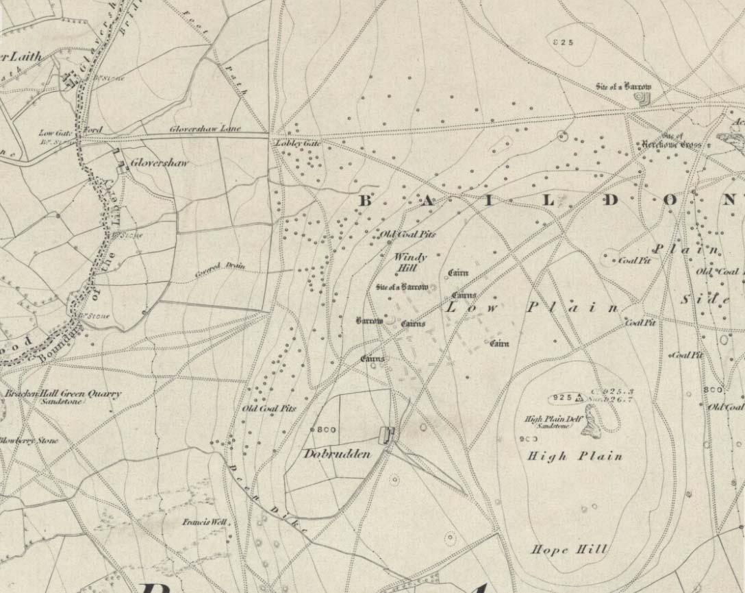
Windy Hill on 1852 map
Archaeology & History
The early northern antiquarian, J.N.M. Colls (1846), described visiting a ‘druidical circle’ of stones due east of the Dobrudden prehistoric graveyard, but it seems to have been completely destroyed soon after he wrote his essay, with the stones taken away for use in road-building. He told that here was,
“a double circle of stones, the outer ring numbering eighteen, with six stones making up the inner circle.”
…and his illustration shows just that! It’s possible that this inner ring may have covered a burial. Harry Speight — aka, ‘Johnnie Gray’ (1891) — is the only other writer I’ve found that refers to the megalithic remains up here, although he gave no additional details.
Windy Hill Circle (after Colls, 1846)
The site was to be found across the High Plain and Windy Hill, on the western edge of Baildon Hill, where there was once a greater profusion of seemingly neolithic and Bronze Age remains. Another possible early reference to the site is in Collyer & Turner’s Ilkley (1885), where they talk of a circle “on the highest part of the eastern moor,” fifty-six feet across with a similar appearance to the Pennythorn Hill circle, although they describe it as overlooking the hamlet of Sconce, which is hardly possible from the Windy Hill side of Baildon Moor.
The site looked across the horizon from south, through west to north and if used astronomically would have been used to observe sun and moonset times. Although we find a number of cup-and-ring stones in the vicinity, it really does seem that this site has bit the dust!
References:
Bennett, Paul, The Old Stones of Elmet, Capall Bann: Chieveley 2001.
Colls, J.N.M., ‘Letter upon some Early Remains Discovered in Yorkshire,’ in Archaeologia 31, 1846.
Collyer, Robert & Turner, J. Horsfall, Ilkley, Ancient and Modern, William Walker: Otley 1885.
Gray, Johnnie, Through Airedale, from Goole to Malham, Elliot Stock: London 1891.