Although ascribed as a wooden ‘henge’ by archaeologist Jean Cook, the site is more accurately a simple timber circle. Cook (1985) described this little-known “Wood Henge” monument, as she called it, sat inside the lower southeastern end of the impressive Dorchester Cursus monument. The site was obviously of some ritual importance, for a variety of reasons. It was excavated in 1981 and,
“it consisted of a ring of large pits enclosing an area some 18m in diameter. The site was situated along the central axis of the (Dorchester) cursus, presumably influenced by the alignment. The pits, which varied in size, had each contained a wooden post, in three instances consisting of an entire trunk of an oak tree. All the posts were burnt in situ, presumably during some form of destruction ceremony.”
Groundplan of site
When Alex Gibson came here a few years afterwards to re-examine the site, his work and that of Richard Bradley (1988) also found the place to have been an elliptical ‘ring’ of once-upright timber posts. Although Gibson (1998) later gave a confused version of where the site actually was (wrong grid-refs), his brief description gave us an outline of what was once here:
“An oval of 12 postholes containing the carbonized remains of 13 posts which had been burnt prior to the placing of cremations in the upper fills of the postholes. The SW posthole contained the remains of two posts in the same socket. There is a possible entranceway, marked by a wider gap between posts, in the NW.”
But this last line appears to be pure speculation. I’ve not read the longer archaeological accounts of this ‘wood henge’ and adjacent sites (Bradley & Chambers, 1988; Gibson 1992), which should give greater details about the site as a whole. The Pastscape site gives the following information:
“A pit circle comprising a sub-circular arrangement of 12 pits was excavated in the early 1980s in advance of work on the Dorchester by-pass. The site lay within the Dorchester Cursus (SU 59 NE 5), circa 400 metres northwest of its southeastern terminal. The long axis of the pit circle was the same as that of the cursus. Each of the pits had held a timber upright, and some if not all had been burnt in situ. An air photograph of the site had suggested the presence of a central pit but this feature proved to be a natural pocket of sand. Six deposits of cremated bone came from various post pipes. Other finds included a handful of potsherds, one possibly of Early Bronze Age date, some animal bone fragments, and a few flints. Radiocarbon dates from cremated bone and charcoal centred on the mid 3rd millennium BC, with one slightly later.”
References:
Bradley, R. & Chambers, R., “A New Study of the Cursus Complex at Dorchester-on-Thames, in Oxford Journal of Archaeology, volume 7, 1988.
Cook, Jean, “The Earliest Evidence,” in Dorchester through the Ages, Oxford University 1985.
Cook, Jean & Rowley, Trevor (eds.), Dorchester through the Ages, Oxford University 1985.
Gibson, Alex, “Possible Timber Circles at Dorchester-on-Thames,” in Oxford Journal of Archaeology, volume 11, 1992.
Gibson, Alex, Stonehenge and Timber Circles, Tempus: Stroud 1998.
Pennick, Nigel & Devereux, Paul, Lines on the Landscape, Hale: London 1989.
Overgrown Pendreich 2 cairn (Pendreich 1 in background)
Take the same directions to get to the Pendreich 1 cairn. Once on the hilltop, look across the moor a short distance to the north and you can just see this overgrown site a couple of hundred yards away. From Pendreich 1 walk down the grassy slope and then up the gentle ahead of you, till it levels out a bit, keeping your eyes peeled for the change in vegetation and colour that gives the game away!
Archaeology & History
Like its companion cairns — Pendreich 1 & 3 — little has been said of the place. Although much overgrown and visible as a small bumpy grassy mass, with the stones beneath the surface, it’s never been excavated as far as I’m aware. It was referred to in the Scottish Royal Commission inventory for Stirlingshire (1963), site no.4, as ‘Mound, Sheriffmuir Road 1’, in which they wrote:
“Another possible Bronze Age cairn is situated on a low ridge, 200yd N of (Pendreich 1), and at a height of a little over 800ft OD. It is a grass-covered, stony mound which measures 20ft in diameter and stands to a height of 9in above ground level.”
References:
Royal Commission on the Ancient & Historical Monuments Scotland, Stirling – volume 1, HMSO: Edinburgh 1963.
Up, round the back of Stirling University, between Bridge of Allan to Greenloaning, take the steep zigzaggy Sheriffmuir Road uphill, until it levels out beyond the main wooded area where the hills open up on either side of you. There’s a little touristy parking spot further along the road, just below a small wooded bit. Keep going on the road for another ¾-mile, until you reach a small scattered copse of trees on your left. At the top of this copse, walk onto the moor on your left (west), following the old walling for more than another 500 yards, where a scatter of old trees live by the wallside. As this bends back downhill, note the rounded hill less than 100 yards above you (north). Go to the top of it!
Archaeology & History
There are several cairns hereabouts; yet despite several visits here, we still haven’t got round to checking them all out, as other little-known archaeological remains keep catching our attention (old walled structures and a possible enclosure). This is the most notable one of the bunch in the region — and easiest to find thanks to it being on top of the small hill where, many years ago indeed, was laid this small round rocky tomb of some long-dead chief, or granny, or someone!
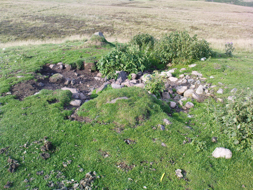
There’s not been much written about this cairn, or its companions (Pendreich 2 & 3). It was referred to in the Scottish Royal Commission inventory for Stirlingshire (1963) where it’s listed as site no.3 as ‘Cairn, Sheriffmuir Road’, but their description is scant. They wrote:
“On a low ridge 800 yards WSW of spot-level 776 on the Sheriffmuir Road, and at a height of 800ft OD, there is a round cairn measuring 40ft in diameter and 2ft 8in maximum height. For the most part it is covered with grass, but a shallow depression in the centre, which may have been caused by excavation, reveals a few boulders.”
Pendreich cairn, looking westExposed section of cairn
Indeed! This cut into the centre of the cairn is somewhat larger than the 1963 description implies, as one of the images here shows. But the grassy mound is pretty clear and there’s certainly something buried beneath here.
The views from here are excellent and gave the spirits the usual panoramic flights across the land, as at many other ancient tombs. The great pyramidal hill of Dumyat rises to the east; and just a few hundred yards away to the north, we find the long laid-out standing stone of Pendreich Muir, whose mythic history has all-but been forgotten…
References:
Royal Commission on the Ancient & Historical Monuments Scotland, Stirling – volume 1, HMSO: Edinburgh 1963.
To reach here, follow the same directions to get to the Apronful of Stones giant cairn. Walk on the footpath past the cairn for about 200 yards until you reach a large gap where the old walling has collapsed. Go through this and walk across the limestone rocks, towards the small rocky hillock rising up 100 hundred yards in front to your east (not the more rounded one to the north). That’s it!
Archaeology & History
This is a most intriguing find, and one to which I can find no other literary reference (though I aint checked Brayshaw’s Giggleswick). An undeniably large natural hillock has been modified and added to by people at some considerable time long ago and at some considerable effort! Measuring more than 47 yards (43m) roughly east-west, and 21 yards (19m) north-south, the most definable man-made remains here is the length of elliptical walling on the southern and western edges. The internal circumference of the enclosure measures roughly 113 yards (103m) all round the edges. The northern and eastern sides of the hill would appear to be mainly natural, but seem to have been modified a little — not unlike the mass of settlements and enclosures a few miles to the east, like Torlery Edge, Lantern Holes and others around Malham Moor and district.
The site needs professional assessment: first to ascertain its period (which seems Iron Age on first impression, but could be much later), and second to ascertain its nature. On the ridges close by we find a veritable mass of archaeological remains, ranging between Bronze Age to Medieval in nature. The giant Apronful of Stones is only 172 yards (158m) south; the Sheep Scar cairn circle 156 yards (143m) northwest; and one of the remaining Sheep Scar cairns only 58 yards (53m) away. And hopefully when we return to the place next week (fingers crossed!), we’ll be able to get some more photos of the walling you can see that define some edges of the site…
…to be continued…
References:
Brayshaw, Thomas & Robinson, Ralph M., A History of the Ancient Parish of Giggleswick, Halton & Co.: London 1932.
Standing Stone (destroyed?): OS Grid Reference – SE 282 402
Archaeology & History
Idol Rock, Adel (Simpson 1879)
Difficult to know what to think about this one. It seems to have been described just once in the latter half of the 19th century by that real Bible-thumping nutcase, Henry Simpson (1879), who gave us the only known picture of the place. Simpson said that it was, “the remains of supposed Idol Rock on the moor near Adel reformatory, under the Alwoodley Crags. About six foot high.” It is believed to have been destroyed, but having not checked the region thoroughly, it could still be there somewhere (the grid reference cited here is an approximation). Does anyone know owt else about it?
References:
Simpson, Henry T., Archaeologia Adelensis, W.H. Allen: London 1879.
Liz Sykes, Saul and I wandered up to see this lovely spot a few years ago, to be found perched upon the top of the grassy boggy ridge a few hundred yards southeast of the Kerrycrusach houses (a coupla miles south of Rothesay, down the B881, on your left-hand [east] side). There are a few easy ways to get up here and it’s a nice amble, though you’ll get yer legs pretty wet if She’s been raining!
Archaeology & History
It was pouring with rain when I visited this small round tumulus with Liz, but a damn good view opened 360-degrees all round us when we hit the spot, the old tomb talking with others scattered on a select few hilltops from here: an obviously important ingredient to those who put it here. Mentioned only briefly in Marshall’s (1978) archaeological survey as being “seen on the skyline looking south from the West Road,” one side of the tomb had fallen away slightly, revealing numerous large pieces of quartz rocks in the construction: another obviously important ingredient (for whatever reason) to the doods who built it. The tomb, deemed as Bronze Age by Marshall, is about 3-4 feet high above the moorland and about forty feet across. Although this tomb officially sits alone here, it’s likely there are other sites close by that have yet to be found.
If little Saul (7 year-old at the time) wouldn’t have been all freezing and saturated and dying to get back home, I’d have sat on top of this old tomb for quite sometime. Twas a fine feeling: hills talking with hills, tombs with tombs, and a soaking-wet Paulus breathing the tranquility of it all.
References:
Marshall, Dorothy N., History of Bute, Bute Museum 1978.
Links:
RCAHMS: Kerrycrusach, Scoulag Moor, Bute – The archaeological info on this old tomb, from the hallowed database of the Royal Commission for Ancient & Historic Monuments, Scotland.
Bittova journey this — but well worth it! From Broughton-in-Furness take the A595 road west, past Duddon Bridge for about another 1½ miles, turning right up the small single-track country lane beloved of city-mind drivers, up the fertile scruffy road, past Broadgate and stopping just before Cragg Hall Farm. There’s a dirt-track running up the back of Cragg Hall. Go up here and keep walking for a mile or so until, as you approach Swinside Farm and the fields open up in front of you, the stones begin to appear.
Archaeology & History
Swinside, looking east
The Swinside stone circle is Aubrey Burl’s favourite. And for good reason! Like other impressive megalithic rings of the region, the stones are large, well set, and the landscape holds the stones finely in the hills. Without the landscape here, Swinside (like Castlerigg and elsewhere) would not have such grandeur. When you sit in the ring, or walk round it, Knott Hill to the south was of obvious mythic relevance to the people who built this stone circle four or five thousand years ago. But this can be said of many of the surrounding crags. A few miles southwest we see the top of the haunted Black Combe rising into clouds, still speaking to some with spirits from animistic realms, long known to our ancestors. Following the skyline west and past the small falls of Whicham stream, whose name speaks of long past trees, we reach the near-west skyline with the cairn-looking pap of the Raven Crag, symptomatic of magickal rites calling to and beyond the circle. To the north is the symbolic ridge of Lath Rigg. Along the craggy eastern ridges from here you get the impression that you’re more in Argyll than Cumbria; and the break in the hills to the southeast reaches to the distant pinnacle of Kirkby Moor, where the midwinter sunrise emerged to tell of solar calendrical motions and the coming of the dark season to our megalithic tribes. But enough of the landscape!
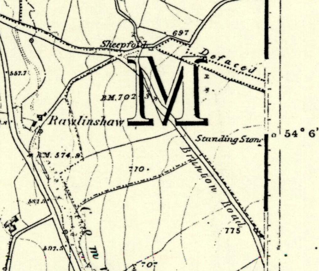
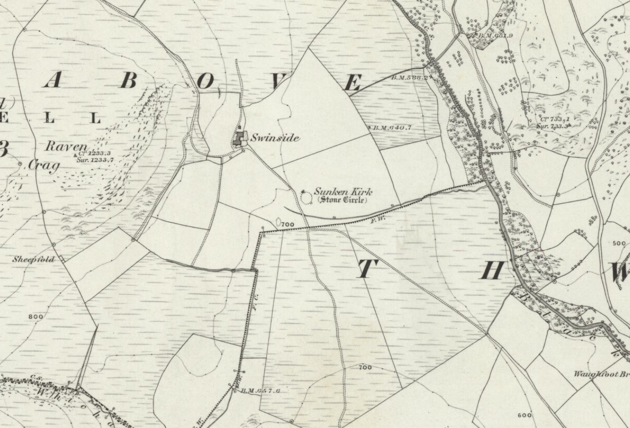
Swinside on 1867 OS-map
Although the name Swinside can be traced back to the 13th century, the local folk-name of the circle—Sunken Kirk—was mentioned for the first time as “the Chapell Suke” in Parish Registers of 1624. No earlier literary source has yet been identified, probably because of the isolation of the site and the lack of people writing about the area. Swinside stone circle is, just about, a perfect circle, give or take a foot here and there, holding the circular dome of the heavens within its domain. Yet despite its almost regal appearance, early references to the site seem scant. It seems to have been first described in William Hutchinson’s huge History of Cumberland (1794), where he told:
“In the neighbourhood of Millum, at a place called Swinside, in the estate of William Lewthwaite Esq., of Whitehaven, is a small but beautiful druidical monument; it is circular, about twenty eight yards in diameter; the stones of which it is composed are from six to eight feet high, all standing and complete. A little to the south, is another of larger dimensions, but not in so perfect a state: the neighbouring people call those places by the emphatical names of Sunken Kirks.”
A few years later, William Camden’s legendary text Britannia was edited and reprinted again, this time by Richard Gough (1806), who told:
“At Swineshead, a very high hill…is a druidical temple, which the country folk call Sunken Kirk, i.e., a church sunk into the Earth. It is nearly a circle of very large stones, pretty entire. No situation could be more agreeable to the Druids than this; mountains almost encircle it, not a tree is to be seen in the neighbourhood, nor a house, except a shepherd’s cot at the foot of a mountain surrounded by a few barren pastures. At the entrance are four large stones, two placed on each side at the distance of six feet. The largest on the left hand side is five feet six inches in height, and ten feet in circumference. Through this you enter into a circular area, 29 yards by 30. This entrance is nearly southeast. On the north or right-hand side is a huge stone of conical form, in height nearly nine feet. Opposite the entrance is another large stone which has once been erect, but is now fallen within the area: its length is eight feet. The left hand or southwest is one, in height seven feet, in circumference 11 feet nine inches. The altar probably stood in the middle, as there are some stones still to be seen, though sunk deep in the earth. The circle is nearly complete, except on the western side some stones are wanting. The largest stones are about thirty one or two in number. The outwards part of the circle upon the sloping ground is surrounded with a buttress or rude pavement of smaller stones raised about half a yard from the surface of the Earth… This monument of antiquity, when viewed within the circle, strikes you with astonishment, how the massy stones could be placed in such regular order either by human strength or mechanical power.”
Tall, northernmost stone to centreNortheast section of the ring
It seems he was impressed! Yet despite this, in the 19th century not many folk strayed this far into the western edges of Lakeland to look upon Swinside. There were occasional descriptions from travellers and antiquarians such as J.T. Blight (1843) and Edwin Waugh (1861), each speaking of the site’s visual magnitude, but it wasn’t until archaeologist C.W. Dymond came here, first in 1872 and then again in 1877, that a fuller account of the site came into being. In his essay on a “Group of Cumberland Megaliths,” he said how the stones were still in excellent condition and that,
“few of the stones seem to have been removed — probably because plenty of material for walling and road-making could be collected from the neighbouring hillside.” (Dymond 1881)
When Mr Dymond first came here he told of the remains of a rowan tree which had split one of the stones, but this has long gone. More than twenty years after the archaeologist’s first visit, he returned with R.G. Collingwood to make a more detailed evaluation of the ring. He measured and planned Swinside like it had never been done before and his ground-plan (below) is still very accurate indeed. Aubrey Burl (1999) takes up the story:
“The ring was partly excavated by Dymond, Collingwood and three men from midday Tuesday, 26 March 1901, until the close of the following evening. They dug two long, intersecting 46cm-wide trenches, NW-SE, NE-SW, across the ring with a curious zigzagging pattern of others between southeast and southwest: an investigation of some 51m² of the central area. Within the circle the trenches represented less than a thirteenth of the 642m² of the interior.
“Below the grass and turf was a thin layer of soil under which yellowish marl or ‘pinnel’ varied from 15cm to 75cm in depth, being deepest at the entrance which had been dug into earlier around 1850. Wherever it was uncovered the gravelly marl was wavily uneven, presumably the result of ploughing. The bases of the circle-stones rested on the pinnel, held firmly in their holes by small cobbles with others heavily packed around the sides. The only finds were a nut-sized lump of charcoal just northeast of the centre with others near the entrance; a minute splinter of decayed bone near the first bit of charcoal and two pieces of red stone. There were also some contemporary glass sherds and a Lancaster halfpenny dated between 1789 and 1794 lying in the uppermost turf layer.”
Dymond’s 1881 plan of Swinside
Since these early archaeological digs, Swinside has given up little else. Much like other stone circles in the British Isles, few real clues as to exactly what went on here have been forthcoming. But in the 1960s, investigations into megalithic sites made a bit of a quantum leap and some old ideas about astronomical ingredients were resurrected.
Alexander Thom’s plan of Swinside
Swinside was one of the places explored by engineer and megalith enthusiast, Alexander Thom. Thom was one of the prime figures instrumental in the resurgence of interest in megalithic sites — and his finds of megalithic astronomy and prehistoric mathematics had a lot to do with it. Although we know today that some of Thom’s work isn’t correct, his explorations and research stand him far ahead of most archaeologists who pretended to represent this area of research. He left us with the most detailed ground-plans of megalithic sites to date and, of course, showed some fascinating alignments.
Thom listed Swinside as site “L1/3” and made the most detailed and accurate ground-plan of this and 18 other megalithic rings in Cumbria. He found it to be 94 feet in diameter, with an internal area measuring 6940 square feet. The one major alignment Thom found at Swinside was of the winter solstice sunrise, lining up just on the edge of the ‘entrance’ to the circle’s southeastern side.
Folklore
Like a number of other stone circles, folklore told that you couldn’t count the stones. Janet and Colin Bord (1997) also told that people once tried to build a church here in early christian days, but once the builders went home in the evening, the Devil pulled down what they’d built during the day. A motif found at Ilkley’s Hanging Stones cup-and-ring carvings and many other prehistoric sacred sites in the country.
References:
Armstrong, A.M. et al., The Place-Names of Cumberland – volume 2, Cambridge University Press 1950.
Bord, Janet & Colin, Prehistoric Britain from the Air, Weidenfeld & Nicolson: London 1999.
Burl, Aubrey, “‘Without Sharp North…’ – Alexander Thom and the Great Stone Circle of Cumbria”, in Ruggles, Clive, Records in Stone, Cambridge University Press, 1988.
Burl, Aubrey, A Guide to the Stone Circles of Britain, Ireland and Brittany, New Haven & London 1995.
Burl, Aubrey, Great Stone Circles, Yale University Press: New York & London 1999.
Burl, Aubrey, The Stone Circles of Britain, Ireland and Brittany, Yale University Press 2000.
Dymond, C.W., “A Group of Cumberland Megaliths,” in Transactions of the Cumberland and Westmorland Antiquarian and Archaeological Society, volume 5, 1881.
Dymond, C.W., “An exploration at the Megalithic Circle called Sunken Kirk at Swinside, in the Parish of Millom, Cumberland,” in Transactions of the Cumberland and Westmorland Antiquarian and Archaeological Society, New Series volume 2, 1902.
Gough, Richard (ed.), Camden’s Britannia, J. Nichols and Son: London 1806.
Hutchinson, William, The History of the County of Cumberland – volume 1, F. Jollie: Carlisle 1794.
Seton, Ray, The Reason for the Stone Circles in Cumbria, R. Seton: Morecambe 1995.
Thom, Alexander, Megalithic Sites in Britain, Oxford University Press 1967.
Thom, A., Thom, A.S. & Burl, H.A.W., Megalithic Rings, BAR: Oxford 1980.
Waterhouse, John, The Stone Circles of Cumbria, Phillimore: Chichester 1985.
Waugh, Edwin, Seaside Lakes and Mountains of Cumberland, Alexander Ireland: Manchester 1861.
ACKNOWLEDGEMENTS:
Huge thanks to Brian Else for his photos. And to Paul and Tricia for taking us here, in awesome downpour weather!
From Feizor village, take the dirt-track south that cuts up between the two cottages and walk onto the level. From here, the walling bends round and a small cut runs up the slope on your left. Go up here and onto the top, bearing left again when you reach the footpath near the top of the slope. Walk along here until the hills open up before you and less than 100 yards along, just on the right-hand side of the path, you’ll notice the overgrown outline of a ring just by the side. Don’t miss it (like I did!).
Archaeology & History
Danny, Paul and I visited here a few weeks back on a fine sunny day and, my attention caught by some nearby rocks that got mi nose twitching, I just about walked past the place until Danny called me back and said, “Oy – ‘ave y’ not seen this?” Right under my nose no less!
Feizor Thwaite circle, looking northwest
The site’s a little known circular monument east of Feizor village, less than a mile northwest of the cairnfield above Stackhouse (where lives the Apronful of Stones and other prehistoric friends). Marked on modern OS-maps as an ‘enclosure,’ the site here is in fact an overgrown cairn circle, typical in size and form of the ones found at nearby Borrins Top, Burley Moor, Askwith Moor and elsewhere in the Pennines. Measuring (from outer edge to outer edge) 66 feet 6 inches east-west and 59 feet north-south, the remains here consist of a raised embankment of stones, encircling an inner flatter region consisting of many smaller stones beneath the overgrowth of grasses and vegetation. Locals told me that the some of the cairns up here were explored early in the 20th century by a local man called Tot Lord, but I’m unsure whether he looked at this one.
There are a couple of other smaller circular remains on the same grassland plain, clearly visible from aerial imagery, along with other crop-marks of human activity on this part of the Feizor Thwaite landscape. More antiquarian analysis could do with focussing here to see what can be found!
Standing Stone (destroyed): OS Grid Reference – SD 78570 67177
Archaeology & History
Feizor on 1851 map
There have been no previous archaeological reference to this site (until now), which was included in early place-names records (Smith 1961) and was also highlighted on the first Ordnance Survey map of the region around 1851. Probably as a result of the archaeological lacking, the upright stone has finally succumbed to the destructive actions of modern man. When we asked the farmer if he knew owt about any standing stone here, he said he knew “nowt abaat that.”
Feizor stone stumpand from another angle
All that can be seen today is the very small stump of stone, just visible above ground level, in the middle of the field. It’s not easy to spot either, as the grasses grow over what’s left. But we found the slim remnant of the stump embedded in exactly the spot marked on old and modern maps, measuring 24 inches in length and just 4 inches across at the widest, with what seemed like worn rounded edges at either end. We were unable to ascertain the depth of the remaining stone in the ground. The stone looks simply as if it’s been snapped at the base. We have no idea how tall this standing stone was.
If any local people know anything more about this stone, or have any old photos, we’d love to hear from you — and would obviously give due credit for any help on this matter.
References:
Smith, A.H., The Place-Names of the West Riding of Yorkshire – volume 6, Cambridge University Press 1961.
Not included in Burl’s (2000) magnum opus, it looks as if this place has long since gone – but perhaps a local or a wanderer might find remnants of it still there somewhere. The only thing I’ve so far found about it is in Martin Martin’s journey here in 1695, where he described this “stone circle in the sea” thus:
“On the east-side of the village Rowdil, there is a circle of stone, within 8 yards of the shore: it is about 3 fathoms under water, and about 2 stories high: it is in form broader above than below, like to the lower story of a kiln: I saw it perfectly on one side, but the season being then windy, hindered me from a full view of it. The natives say that there is such another circle of less compass in the Pool Borodil, on the other side of the bay.”
Local people say that the structure is a natural one, with others of a similar nature found close by. Does anyone know more about this – and perhaps about the other apparent circle at Borasdal, less than a mile to the west?
References:
Martin, Martin, A Description of the Western Islands of Scotland in 1695, Eneas Mackay: Stirling 1934.


")


")
")