Stone Circle: OS Grid Reference – SE 2056 6507
Archaeology & History
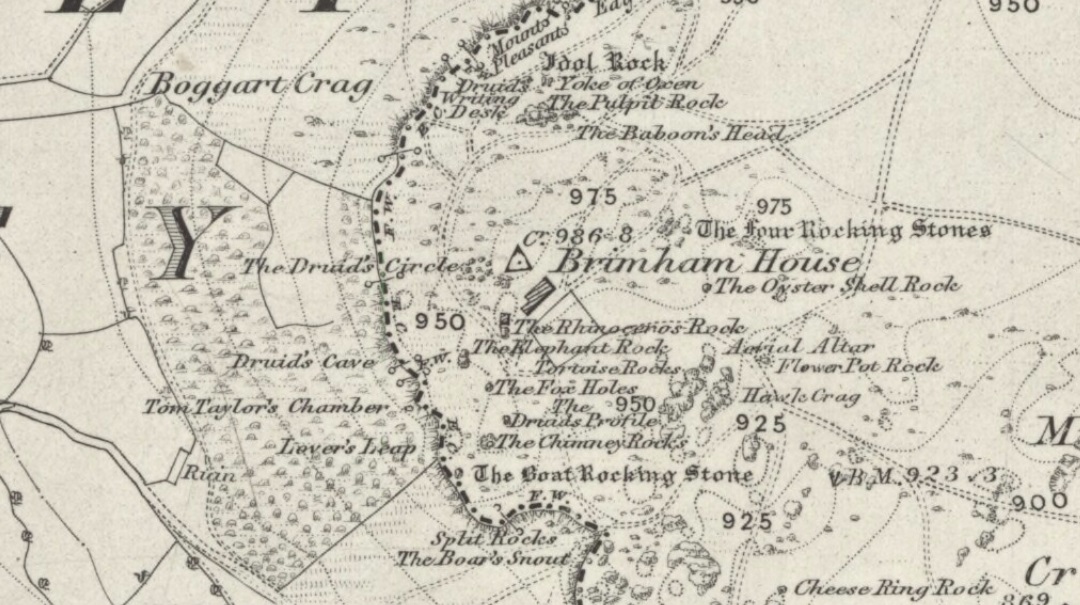
A site that was illustrated by the early Ordnance Survey lads between the haunted Boggart Crag and Brimham Rocks to the south, I haven’t thoroughly explored this area so don’t know if anything at all remains of what was described. It may or may not have been an early folly. The earliest reference to this missing circle comes from Mr Hayman Rooke’s (1787) essay on the Brimham Rocks complex in Archaeologia journal. Described in context with other prehistoric remains in the locale, Mr Rooke said,
“About a quarter of a mile further to the west (of Brimham Rocks) is a Druid circle, with a vallum of earth and stones, thirty feet diameter. It is exactly of the same construction as those on Stanton Moor, in the Peak of Derbyshire. There are likewise several small tumuli. Thirteen of them are ranged in a kind of circle, the largest not above eighteen feet in diameter. They are formed of earth and large stones. Two of these I opened; towards the bottom the effects of fire appeared on the stones; and ashes were scattered about, but there were no urns to be found.”
This description was echoed a few years later by Ely Hargrove (1809) and reiterated by Godfrey Higgins (1829) in his work on the Druids, but neither authors added anything new (strongly implying they never actually saw this ‘circle’). The last description I’ve found of the site is in Mr Speight’s (1906) survey — which gives the reality of the site considerably more credence! He told us:
“About 80 yards west of the Cannon Rock is a large tumulus, and about 300 yards still further is a Druid’s Circle, thirty feet in diameter, mentioned by Hargrove in 1809.”
But that’s it! Nowt else! It would seem from Hooke’s initial writing, that we are perhaps looking at a lost cairn circle in this locale, but until someone finds it we will never know for sure.
Intriguingly, there are a number of other prehistoric remains not far from this seemingly lost ‘circle’. There’s a large standing stone not far away on Standing Stone Hill a half-mile south (kinda gives the game away really, dunnit!?) which I first saw as a kid; some cup-and-ring stones nearby; and the seemingly lost tumuli of Graffa Plain, southeast of Brimham Rocks, showing that prehistoric folk were up to the usual tricks nearby. But the ‘circle’ is seemingly lost. Is there anyone out there who knows anything more about yet another one of Yorkshire’s lost stone circles? More information about the circle or the tombs would be very welcome!
References:
- Hargrove, Ely, The History of the Castle, Town and Forest of Knaresborough, Hargrove & Sons: Knaresborough 1809.
- Higgins, Godfrey, The Celtic Druids, R. Hunter: London 1829.
- Rooke, Hayman, “Some Account of the Brimham Rocks in Yorkshire,” in Archaeologia journal, volume 8, 1787.
- Speight, Harry, Upper Nidderdale, with the Forest of Knaresborough, Elliot Stock: London 1906.
© Paul Bennett, The Northern Antiquarian


")
")