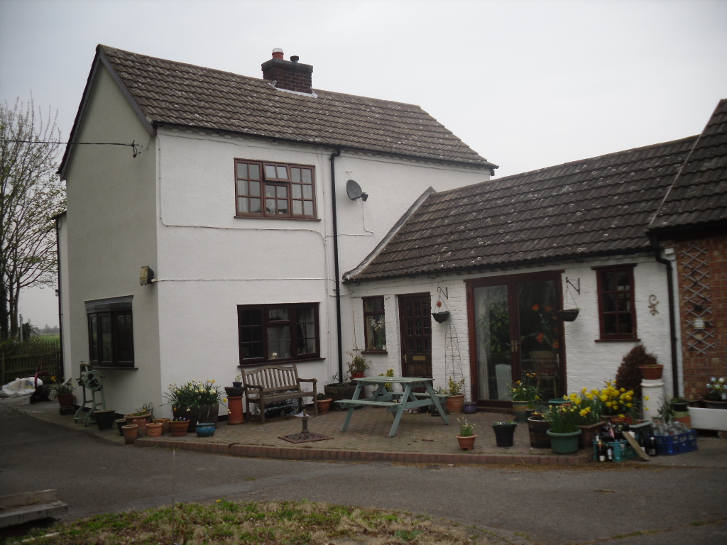
One of the most unusually sited of Nottinghamshire’s holy wells is St. John’s Well at Welham. It lies beneath a private kitchen floor in a house in Bonemill Lane in Welham, just off the Clarborough Road out of Retford.
Archaeology & History
The well itself is undoubtedly an ancient one. The Domesday Book refers to ‘Wellun’; this changed to ‘Wellum’ by 1166, and by the 16th century had become ‘Wellom’; but in Chapman and Andrews map of Nottinghamshire in 1775 was shown as ‘Welham’. None of these sources call it St John’s Well and it is not so named until 1710, either as a re-dedication once the Reformation zealouts had died down, or perhaps coined by John Hutchinson to give the bath a story to explain its healing waters. It is shown on Chapman’s map of Nottinghamshire (1774) as ‘Well House’. Piercy (1828) gives the greatest information and states that the hamlet of Welham was named after St. John’s Well whose waters contained magnesium and gypsum and was:
“good for rheumatics and scorbutic diseases. Its waters formed into a large bath, and remained entire during the early part of the 18th century, it was famous for many cures, but latterly it has lost much of its celebrity.John Hutchinson, Esq. erected a cottage adjoining, and enclosed the bath, to preserve it from injury. Cold baths like this were formerly regarded with superstitious reverence, being supposed to possess a sovereign remedy for agues such as rheumatism.”
The well-coverLooking into the well
By 1832 White’s Directory notes that it had lost much of its former celebrity. A Robert Walker was a bath keeper at the Well house and may well have been the last one as it appears the well soon fell into terminal decline and I can find nothing is noted of it until 1938. At this time it is noted that its water was still used to provide several cottages in the village. An article written in 1957 states the bathhouse disappeared stating the coming of the railway encouraged people to move away to find more effective spas around the 1830s. It goes on to note that the actual spring location was lost. This I thought was to be the situation, but local investigations not only showed the house to be still existence but the bath still remained! Records show that the estate, was bought by an Arthur Robert Garland of Welham Hall from the deceased estate of John Henry Hutchinson of Clarborough Hall acres117.3.16 along with Well House Cottage and garden for the sum of £3200 on in 1910. He then sold the cottage and garden to Fred Anderson on 1910 for £130. This was subsequently bought by the late Mr Eric Durham on 1955, later to be purchased by the current owner, Mr Whelan, in 1975.
The present house, although it had been added onto in the last century, has its core fabric as John Hutchinson built it. The large house being the well keeper’s abode with the side building, now a modern kitchen was the bath house. Arriving at the house, I was at first shown the site by Mr. Whelan the spring which filled the bath which was diverted to the side of the house, the spring itself arising close to the footpath behind the house. A man-hole cover in the drive way revealed that the spring flows at a fast rate, several gallons per minute. He notes that it had a very high mineral content, soaking through the gypsum in Clarborough hills. He stressed it is drinkable, in small quantities, due to its high magnesium and sulphate (like Andrews Liver Salts). It is quite chalky to taste flat but is very pleasant to drink if aerated. However he did not recommend long term drinking was probably not good for one’s health.
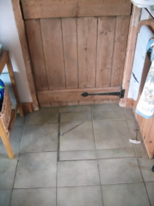
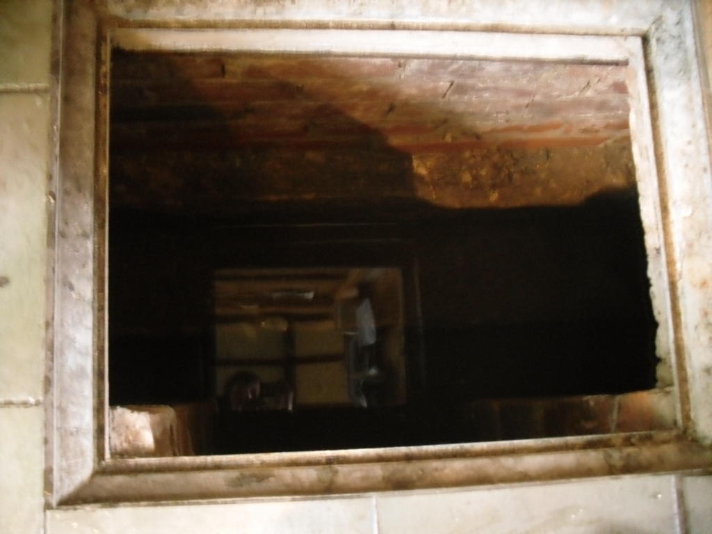
In the kitchen, a small trap door can be removed and beneath the remains of the bath is revealed. This appears to as Mee (1938) describes; a stone basin twelve feet square with a flight of steps entering the water. I scrambled down into this bath and found it presently to have two stone steps which enter the bath, although bricks built upon these suggest that there may have been more.
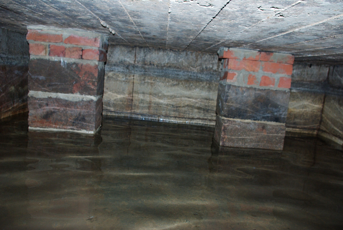
Remarkably the bath still remains enclosing an area fifteen feet by twelve feet, and despite the water being diverted, was full to over a two foot of water. The present kitchen is supported by four brick pillars but this does not appear to have damaged the fabric of the bath which is in fine condition, being made of good quality neat squared stonework. A pipe is found four feet high or so in the wall and a line around it made by the presence of water indicates that the water was of a considerable depth supporting the fact that it was large enough to be a hazard, explaining how Thomas Heald, Vicar of Babworth drowned in it on the 18th June 1759. Mr. Whelan informs me that although the house is not a listed building previous owners had sensibly preserved the bath. Around 30 years ago he was often showing local school children, but it appears now to forgotten. So there it remains a curious relic preserved in its most unusual place.
Folklore
John Piercy (1828) notes:
“Here was, until lately, a feast, or fair, held annually on St. John’s day, to which the neighbouring villagers resorted to enjoy such rural sports or games as fancy might dictate.”
What is interesting about this account is the reference of games and a fair suggesting that if the well itself did not have such a dedication, the saint was celebrated in the locale. This may indicate that indeed the well was so dedicated or that Hutchinson chose this name because of the local fair. Without further information we shall never know.
It must be noted that due to its location, under a private kitchen, that the site is not readily viewable so please don’t turn up unannounced.
References:
Mee, Arthur, Nottinghamshire, Hodder & Stoughton: London 1938.
Parish, R.B. (2010) Holy Wells and healing springs of Nottinghamshire
Tumulus (destroyed): OS Grid Reference — NT 237 861
Archaeology & History
Very little is known about a prehistoric tomb that once existed near the coast at Craigkennockie. Its existence was briefly described in Andrew Young’s (1913) fine history of the township where he told that it had been highlighted on an old Estate Map of the area and marked as, “an artificial cairn, probably a place of sepulture.” On old maps just below the cited place we find the place-name of ‘Lammerlaws’, which may indicate a name once given to the site, as the element -law is commonly found relating to prehistoric cairns.
Although the modern place-name researchers in central Scotland have opted that the word ‘law’ is primarily “a rounded hill”, they have curiously forgotten or omitted its other derivation. Throughout northern England and beyond, the English Place-Name Society finds that many ‘law’ place-names derive from the old English and Saxon word, hlaw, which is originally told to be “a mound, a hill.” This has been the reference cited throughout in Taylor & Markus’ (2006-2012) otherwise fine multi-volume analysis of Fife county. But there’s much more to it than that. I hope that readers will forgive me reciting A.H. Smith’s (1956) full entry about this simple term, as it can (and many times does) show our history is much richer than initially thought. Prof Smith told that law, hlaw, hlæw, has the following etymological origin:
“(1) In OE (old English) the common meaning in literary contexts is ‘an artificial mound, a burial mound, a mound in which treasure is hidden’, as in Boethius Metr. 10.43, ‘in what hlæwa do the bones of Weland cover the ground?; Beowulf 2802, ‘Bid them make a hlæaw…on Hronesnæsse’; Guthlac 4 ‘there on the island was made a great hlæw, which through the lust for treasure had been dug up and broken into’; or Gnomic Verses 26, ‘a dragon shall be on hlæw’, an allusion (as in Beowulf 2773) to the Germanic tradition that mounds containing valuable grave-goods were guarded by dragons. The word glosses Latin, agger, ‘something heaped up, a mound, a rampart’ (Wright’s Anglo-Saxon & Old English Vocabularies 355.4). This meaning ‘tumulus, artificial mound, burial mound’ is well attested in place-names. According to Grundy, it always denotes a tumulus in the OE charters and doubtless those place-names in which it is combined with personal names are the burial places of the men so named; at Taplow at least a remarkable burial treasure was discovered and Cuckhamsley, Berkshire, is named from Cwichelm, the West Saxon king who died in 593. The majority of such places-names belong to the heathen period when this method of disposing of the dead was practised. Particular compounds also suggest that it could be an artificial mound which formed the centre of a place of assembly; Oswaldslow Hundred (Place-names of Worcestershire, 87), for example, was created in 964 and it was to meet at a place to be henceforth called Oswaldeslaw in honour of Bishop Oswald (Cartularium Saxonica 1135).
“(2) The meaning ‘hill, a conical hill resembling a tumulus’ is also found in OE, as in Leechdoms Vol.3, 52, ‘they rode over the hlæw’, and local topography establishes this meaning as a common one in place-names and dialects in certain parts of the country; it survives as law in Durham and Northumberland and as low in northwest Midlands…
“(3) The two forms hlaw and hlæw are on record, the latter being better evidenced in literary use, especially in West Saxon texts, and the former in place-names; hlæw normally becomes low, north country law, whilst the i-mutated hlæw (found in place-names only in the south and south Midlands) later becomes lew, as in Lew, Oxfordshire, Lewes, Sussex and is more frequent in middle-english spellings; it is often later replaced by –low as in Dragley, Lancs, Cuckhamsley, Berkshire…”
Smith continues with many topographical evidences regarding a ‘burial-mound’ derivation for the place-name ‘law’, finally adding notes on relative linguistic similarities, like the “Gothic hlaiw, ‘grave’; old High German hleo, ‘grave mound, hill’; old Saxon hleo, ‘grave mound’…” It seems pretty convincing, and so we need to take this into account in our walks over the hills if we are exploring ancient history.
As if to emphasize this derivation—’law’ as prehistoric tombs—we find it is cited in the massive Scottish National Dictionary (6,1:16) where—alongside the ’rounded hill’ aspect—Mr Grant (1962) tells it to be,
“An artificial mound or hillock, specif.: (1) a tumlus or barrow, grave-mound….”
thereafter giving a number of Scottish examples. The same meaning is echoed again in the modern version of Concise Scots Dictionary (2005), along with the rounded-hill. Jamieson’s (1885) Scottish Dictionary cites similarly, ‘law’ as both hill, aswell as “a tomb, grave or mound.”
This association of ‘law’ with ancient burial mounds in Scotland should not be that surprising. Despite it having an Anglo-Saxon origin, we must remember that the Saxon kingdom is known to have stretched all the way up to the Firth of Forth (Edinburgh) and across to Glasgow. So if the linguistic roots have any credibility at all, it doesn’t take much stretch of the imagination to have this simple word travel further north amongst the people. Perhaps this is why, more recently, Margaret Gelling (2000) has said that the association of hlaw with burial mounds up here lessens in Scotland. Nonetheless, let us not presuppose one meaningful definition of the word above another, as it can, consciously or otherwise, be seen as more symptomatic of the all too common English attitude of papering over another country’s rich and ancient heritage by depleting its language—again…
(Law has another element attached which has all but fallen out of historical analysis. Prof Smith touched briefly upon it, mentioning ‘law’ as being a meeting place—otherwise known ‘moots’. Moots occurred everywhere in early times: in England, in Europe and in Scotland too. They were originally where local tribal gatherings took place, for the purpose of what we might call council or political decisions, amongst other things. Some of these moots occurred on burial mounds of great age, aswell as stone circles—and evidence indicates that some of them originated way back in prehistoric times. Although written accounts of many such moot spots have fallen from historical texts, the term law or low (and their variants) is again found in Scottish etymological and topographical lore. Mr Grant again cites it to mean:
“Law cairns, or court cairns…the judicial sites of baronial court of justice…”
Thereafter giving numerous citations of its use in both the common tongue and sites where it is known. As far north as the Shetland Isles, where such law-courts aer known from the Scandinavian ting of thing, the 18th century Statistical Account of Tingwall states there being “the Law Stone” at the cite of the parish court.)
Folklore
Also in Mr Young’s (1913) work, he told how this old tomb was a place that seemed cursed or should not be disturbed, saying,
“About 50 years ago, any illness in the neighbourhood of Craigholm was ascribed to the influence of this burial place…”
adding that an adjacent spring of water, of high esteem, was close by.
References:
Grant, William (ed.), Scottish National Dictionary – volume 6, SNDA: Edinburgh 1962.
Jamieson, John, Etymological Dictionary of the Scottish Language, W.P. Nimmo: Edinburgh 1885.
Robinson, Mairi (ed.), Concise Scots Dictionary, Aberdeen University Press 2005.
Smith, A.H., English Place-Name Elements – volume 1, Cambridge University Press 1956
This long-lost medieval ornamented cross, found not far from the legendary Grope Cunt Lane (I kid you not) was located close to the middle of old Shrewsbury town, “at the junction of Pride Hill, Castle St and St. Mary’s St,” according to the 1902 OS-map of the region.
Although Shrewsbury’s High Cross is believed to have been built in the 12th or 13th century, we don’t know for sure when it was first erected — and indeed, written records of the place don’t appear to begin until the year 1557, where it was described as the ‘Hye Crosse.’ A few years later in the Parish Registers for the Lichfield diocese, dated 1590, the monument was mentioned again as ‘the Highe Crosse’; and subsequent accounts of it are found in various local history accounts from 1695 to 1799.
The site was named as the Butter Cross in street-name listings of 1804, telling it as a site where this food was sold and we know that the High Cross was the centre of a local market and social gathering place in previous centuries. Gelling (2004) told that “the medieval cross was taken down in 1705, but the name continued to be applied to structures which replaced it, and which were used as a market place for dairy produce.”
In earlier times, the High Cross is said in legend to have been where executions were enacted. Alfred Rimmer (1875) narrates the oft-told tale of those who died here, saying:
“The High Cross of Shrewsbury has long been destroyed, but its place is pointed out in old documents. Unhappily, it is not connected with pleasant associations, for before it the last of the British princes, David, a brother of Llewellyn, was cruelly put to death by Edward I; and at a later period many of the nobility who were taken at the battle of Shrewsbury were there executed, the High Cross being considered the most appropriate place for such a spectacle.”
The prince that Rimmer mentions was Dafydd III, the last prince of Wales, executed in the year 1283.
References:
Gelling, Margaret, The Place-Names of Shropshire – volume 4, EPNS: Nottingham 2004.
Hobbs, J.L., Shrewsbury Street Names, Wilding & Son: Shrewsbury 1954.
Rimmer, Alfred, Ancient Stone Crosses of England, Virtue: London 1875.
Stone Circles (destroyed): OS Grid Reference – SE 170 810
Archaeology & History
I was hoping to get a Northern Antiquarian team to explore this arena before moving to Scotland, as I lived in hope that we might uncover some remains of an important cluster of megalithic rings in this quiet North Yorkshire area — but we didn’t manage to get here. So this short profile is one based purely on texts.
A mile east of the standing stone and impressive cup-and-ring carvings of West Agra, was once to be found several stone circles — according to John Fisher (1865), who told us about them in his magnum opus on the history of the region. Not to be confused with the giant Druid’s Temple a couple of miles south, Fisher was contextualizing them with the “huge circles of upright stones” which our great heathen ancestors built. Although he made some mistakes trying to link the local place-names with these stone circles (a common pastime of Victorian writers), his remarks still make interesting reading. He told that,
“In this parish there are places which fully answer to this description, as well in situation and appearance, as in the names which they still bear. I refer more especially to Healey-Baals, Beldin Gill, and Baal Hill, which latter place is situate either upon or near to the range of hills known by the name of Healey-Baals. The very name of Baal-Hill, without reference to its appearance or locality, indicates that the place is a hill dedicated to the worship of the heathen god Baal; and the name Healey-Baals, according to the interpretation which I put upon these words, is, if possible, still more conclusive of the matter. I take it that the name of Healey is derived from Heil, holy or sacred, and ley, land consisting of fallow-ground, pastures, or meadows. If, therefore, I am right in my interpretation of the name of Healey, then Healey-Baals means simply land sacred to Baal. This supposition is strengthened by the circumstance of circles of upright stones having recently existed near to the place, and from ancient relics which have been found within the parish, and at but a short distance from Healey and Healey-Baals, which are supposed to have been used in the mystical rites of the Druids or priests of Britain, for at least antiquaries can assign no other use to them…”
There are very few other references I can find that tell of these lost stone circles. Edmund Bogg (1906) mentioned them briefly, saying that between Fearby and the hamlet of Healey a mile west, “there were formerly circles of upright stones and other relics suggestive of druidical origin.” But there’s little more.
In exploring the local field-names we find that three of them here carried the name “Standing Stones” – which seems to tell us where once we could find these old stones. It may be possible that some of the stones were removed into the hedgerows at the sides of the fields.
Folklore
Fisher told of the local tradition of quarterly fire ceremonies close by, which he thought may have related to religious practices at the stone circles, telling:
“There are traditions, too, which have been handed down to us, to the effect that the heathen custom of making feasts and Baal-fires (which although unknown to the persons making them, were in truth so made in honour of Baal) have been continued until very recent times in this district — and especially in Nidderdale — the remembrance of which is transmitted to us in the annual feast which is still held at Healey.”
References:
Bogg, Edmund, Richmondshire and the Vale of Mowbray, James Miles: Leeds 1906.
Cunliffe-Lister, Susan, Days of Yore, privately printed: Bath 1978.
Fisher, John, The History and Antiquities of Masham and Mashamshire, Simpkin Marshall: London 1865.
Smith, A.H., The Place-Names of the North Riding of Yorkshire, Cambridge University Press 1928.
Standing Stone (destroyed): OS Grid Reference – NS 99 77
Archaeology & History
Not included in the Canmore listings, nor that of the Scottish Royal Commission (1929), this lost standing stone once stood somewhere in Linlithgow town itself. It was referred to in the huge but obscure Registrum Magni Sigili Regum Scotorum from 1586 through to 1614 as one of the street-names in the town, written several times as ‘Standandstane’ — which, as MacDonald (1941) told in his fine survey, means literally a “Standing Stone.” The place was also referred to several times in other local accounts, dating from 1664, but was last mentioned in 1699 and, it appears, disappeared soon afterwards.
Perhaps some record of the site may be available in local witchcraft or folklore accounts. Does anybody know?
References:
MacDonald, Angus, The Place-Names of West Lothian, Oliver & Boyd: Edinburgh 1941.
Royal Commission on the Ancient & Historical Monuments of Scotland, Inventory of Monuments and Constructions in the Counties of Midlothian and West Lothian, HMSO: Edinburgh 1929.
Follow the same directions as if you’re visiting the Apronful of Stones giant cairn, above Giggleswick. Walk past the giant cairn for a coupla hundred yards until you reach the large section of fallen walling, which you can clamber over and head towards the small rise of the Sheep Scar enclosure 100 yards in front of you. Walk to the far end of this walled enclosure and look down the slope to your left, for 50-60 yards where you’ll see a small rocky mound rising above the edge of the hollow footpath. That’s it!
Archaeology & History
This lovely old overgrown prehistoric cairn seems to one of what were once the remains of many other old tombs that scattered this grassy rocky plain, on the western ridge between Stainforth and Settle. Although there are what seems to be the remnants of others nearby, this particular stone heap, its edges buried beneath centuries of earth, is a fine little-known specimen that deserves attention after so long a period in the sleep of ignorant moderns. The cairn is found within an area that Harry Speight (1892) called the “Field of the Dead”, where he came across “traces and remains of human graves which carry us back to the far dim ages of unwritten history.” Whether he saw this particular cairn rising up above the edge of the old track that winds up from Borrins in the valley below, he doesn’t say — but I’d be amazed if the diligent Speight missed it!
The overgrown cairn, looking NWCairn centre, with Sheep Scar enclosure above
Standing more than a yard high, when Paul Horby and I paced this old ruin, it measured 10 yards by 12 yards across — though so much loose and overgrown stone was beneath the surface that it could be much bigger. The top of the cairn had come loose, perhaps explored by some antiquarian in times gone by, exposing a considerable mass of small rounded and misshapen rocks, typical of such constructions. When Harry Speight found the place more than a hundred years earlier, he described the situation much as we’d found it, telling of,
“other mounds of similar and smaller dimensions within the same area, some of which have been examined, but others do not appear to have been disturbed. Many of the barrows or ‘raises’ have at some time or other been carelessly dug into in the hope of finding valuables, and as doubtless in most cases nothing was found but rude chests or coffins, containing bones, these were tossed aside and no record of them deemed worthy of preservation.”
A situation we find still prevalent thanks to the ignorance of some archaeologists in some regions of Yorkshire to this day (despite what they tell folk). We could see nothing of any note in our brief look at this old cairn, except that it had the usual hallmarks of prehistory in its form, probably Bronze Age. Possible remains of other similar-sized cairns can be seen a little further up the slope on the northeastern edges of the enclosure. The prehistoric Sheep Scar Cairn Circle and other ancient remains scatter the fields all round here; something indicated by the place-name Borrins found in the woods below the ridge, meaning simply, ‘burial place.’ (Smith 1956: 57-8)
References:
Smith, A.H., English Place-Name Elements – volume 1, Cambridge University Press 1956.
Speight, Harry, The Craven and Northwest Yorkshire Highlands, Elliott Stock: London 1892.
There appear to be no records of any prehistoric circle of any form in the area less than a mile northwest of Whaley Bridge, where the intriguing place-names of Ringstones Clough and Ringstone farm can still be found, nearly 750 years after first being mentioned in local history records. Described by place-name authority J.M. Dodgson (1970) to be simply a “ring of stones” or “stone ring,” little is said of the place in Aubrey Burl’s standard texts. Thankfully we are helped out by R.A. Barnett, who found a reference to the place in John Barnatt’s (1990) local survey, where he gave us a bit of local lore:
“A local man working at the farm said there was a stone circle under the concrete floor of the buildings and that he had seen a photograph showing men sitting on the stones…….. It is not known how much credence to place on this account, it may well be apocryphal.”
Nobody as yet has located this alleged photo. It would be great if anyone could find it!
The site was first mentioned as early as 1285 AD in records of the Palatinate of Chester, as both ‘Ryngstones’ and ‘Ryngstanes’; then later in the Minister’s Accounts of 1550 as the name we know today. But another document found in the Public Records Office dated 1357 AD describes simply le Rynge, or “the ring” itself perhaps. It is described consistently as the standard place-name in numerous other documents from thereon. Was this a cairn circle? A stone circle? A circular enclosure? And where exactly was it? What monument gave this area of land its name?
Good looking contenders for the position of the circle include both Brownough Hill and Black Hill; and what is the story behind the Dipping Stone, above the original source of Ringstone Clough?
References:
Barnatt, John, The Henges, Stone Circles and Ringcairns of the Peak District, Sheffield Archaeological Monographs 1990.
Dodgson, J.M., The Place-Names of Cheshire – volume 1, Cambridge University Press 1970.
From Marsden itself, take the A62 road west and where the road bends round, the large hill rising on your left is where you’re heading. There’s a parking spot near the bottom of the highest part of the hill. From here, walk right to the top, up whichever route you feel comfortable with. At the very top is an intrusive modern monolith (dedicated to somebody-or-other, which the fella wouldn’t approve of if he really loved these hills*). About 10 yards east of the stone is a small grassy mound with a bittova dip in the middle. That’s it!
Archaeology & History
This is a little-known prehistoric site, whose remains sit upon a very well-known and impressive hill on the western edges of Marsden. Described in Roy Brook’s (1968) excellent survey on the history of Huddersfield as “the most important site” from the Bronze Age in this region, it seems curious that the attention given to it has been relatively sparse and scattered. The tops and edges of the hill have been cut into and worked upon by the uncaring spade of industrialism (of which there is much evidence), aswell as much of the peat being used for fuel over countless centuries — some of which appears to have been cut close to the all-but-lost remains of this once-important burial site.
The first description of the hill itself seems to be in 1426, where it was named in the Ramsden Documents, “past’ voc’ le Pole.” (Smith 1961) It wasn’t until appearing as Puil Hill on the 1771 Greenwood map that the title we know of it today began to take form. Local people would alternately call it both Pule and Pole Hill. But its name is somewhat curious, as the word appears to derive from the variant Celtic and old English words, peol, pul and pol,
“meaning a pool or marsh, especially one that was dry in the summer. Pole Moor therefore means Pool or Marsh Moor…and Pule Hill = the hill in the marsh.” (Dyson 1944)
Remains of mound looking NWSmall mound at left-centre
However, in Smith’s English Place-Name Elements, he gives an additional piece of word-lore which seems equally tenable, saying the word may be “possibly also ‘a creek'”, which could be applied to the water-courses immediately below the west side of the hill. We might never know for sure. But the archaeological remains on top of Pule Hill have a more certain history about them…
The burial site first appears to have been mentioned in a short article by Henry Fishwick (1897), who wrote:
“Whilst searching for…flints on the summit of Pule Hill a few weeks ago a discovery was made which is of considerable antiquarian interest. On the highest point of the hill, and from 12 to 18 inches below the surface, were found two human skeletons lying on their sides almost directly east and west, the knees of both being drawn up. Near to them were two small circular urns measuring 4¾ inches high, 5 inches across the top, and 6 inches in diameter at the widest part, the base being 3 inches across. These are made of native clay very slightly burnt, and are ornamented with short lines (apparently cut with some sharp instrument) which forms a rough herring-bone pattern. On the centre band are four ears or small handles which are pierced so as to admit a small cord. The urns contained animal matter and a few calcined human bones.
“Since the discovery of these two urns another has been exhumed from the same place. It measures 3½ inches in height and 7 inches in diameter at the widest part, which is just below the rim of the mouth. Its ornamentation is similar to the others, but quite so elaborately executed; the base is made with four feet or claws. On one side of the urn is an ear or handle pierced with a small hole in the direction of a double-groove, in which it is placed; there is a second double-groove near the bottom. When found this urn only contained sand. Fragments of a fourth urn were discovered on the same spot… The discoverers of these were Mr G. Marsden and Mr F. Fell.”
As a consequence of this, a couple of years later members of the Yorkshire Archaeology Society took it upon themselves to have a closer look at the place — and they weren’t to be disappointed. They cut a large trench across the top of the site from east to west, digging down until they hit the bedrock of the very hill; then dug an equal trench as much as 30 yards to the north, and on the southern side to the edge of the hill near where it drops. They came across,
“In three places were found distinct cavities…driven into the rock to a depth of about eighteen inches, the dimensions of which…averaged three feet long by two feet wide.”
Drawings of urns & bowls (Manby 1969)Mr Petch’s old photos of the bowls & urns
Within these rock cavities they found small portions of bone, charcoal and flint. It was also found that the urns which were described earlier by Mr Fishwick, had been found laid on their sides “at the places where the cavities were subsequently discovered.” Inside the urns, the remains of various human bones were discovered and reported on by Mr Boyd Dawkins: a craniologist of some repute in his time.
The discoveries were remarked upon a few years later — albeit briefly — in D.F.E. Sykes (1906) excellent history work of the area, where he told us that it was one of his esteemed friends, “George Marsden of Marsden…who was fortunate enough in August, 1896, to find” the ancient remains. But perhaps the most eloquent description of the Pule Hill remains was done by James Petch (1924) of the once-fine Tolson Museum archaeology bunch in Huddersfield (still open to the public and very helpful indeed). Mr Petch wrote:
“Several Bronze Age interments have been found in the locality. Of these the most important is that discovered on the summit of Pule Hill and excavated in 1896 by the late Mr. George Marsden. The finding of an arrowhead led to digging and four urns containing burnt human remains, and so-called “incense cup” were uncovered and removed (Figures 24, above, and 25, below) . In 1899 the site was again opened up for further examination. It was then noted that the urns had been set in cavities dug into the rock to a depth of about 18 inches. The type of the urn fixes the interment as belonging to the Bronze Age, and characteristic of such interments are the rock-cavities. The site is however somewhat exceptional in that no trace was found of the mound which was usually heaped over an interment. As the site is very exposed, the mound may have been weathered away, leaving no traces visible to-day. Along with the urns were found an arrowhead, one or two scrapers, a disc, a few pygmies and a number of flakes and chippings. It is important to note that these flints are mostly the relics of a Mas d’Azil Tardenois workshop which existed long before the interment was made on the summit of Pule Hill, and that they have no necessary connection with the Bronze Age burial…
“Owing to the generosity of the late Mr. George Marsden, the discoverer, and his family, the urns are now in the Museum. They form one of the most striking exhibits in the Prehistoric section. They are illustrated in Figures 24 and 25, above.
“The smallest of the group (Figure 24, 1 and 2, above) belongs to the type known as “incense-cups,” this name being the result of a somewhat fanciful attempt to account for the perforations the examples always show. It is quite evident and widely recognized now that this explanation – that they were in fact censers – is unsatisfactory, and that the use of this peculiar type of vessel is a problem as yet unsolved. Nos. 3 and 4 and Fig 25, 1 and 2 (above), are styled “food vessels,” such as may have been their ordinary use.
“No. 3 is ornamented with slight indentations, and without lugs; it has two strongly marked beads around the mouth, with a distinct groove between them. No. 4 has two slight lugs opposite to one another, which appear to have been pinched up from the body of the vessel; they were perforated but the holes have been broken out. Fig. 25, Nos 1 and 2 (above), is the best of the series, it is ornamented with small cone-shaped indentations and shows several unusual features; the width is great in proportion to the height; the lugs are not opposite and were attached to the vessel after it was made; the one on the left is seen to be perforated, and the position of the second is above the figure 2 in the illustration. The four feet were attached in a similar manner, and are not solid with the body of the vessel. All the vessels are hand made and show no indication of the potter’s wheel.”
Ceremonial bowl from the site (J. Petch 1924)
The site has subsequently been listed in a number of archaeology works, but there’s been no additional information of any worth added. Manby (1969) noted that of the four vessels from this prehistoric ‘cemetery’, one bowl was of a type more commonly found in East Yorkshire — though whether we should give importance to that single similarity, is questionable.
One thing of considerable note that seems to have been overlooked by the archaeological fraternity (perhaps not too surprising!) is the position of these burial deposits in the landscape. To those people who’ve visited this hill, the superb 360° view is instantly notable and would have been of considerable importance in the placement and nature of this site. The hill itself was probably sacred (in the animistic sense of things) and is ideal for shamanistic magickal practices. The communion this peak has with other impressive landscape forms nearby – such as the legendary West Nab — would also have been important.
For heathens and explorers amongst you, this is a truly impressive place indeed…
Barnes, Bernard, Man and the Changing Landscape, Eaton: Merseyside 1982.
Brook, Roy, The Story of Huddersfield, MacGibbon & Kee: London 1968.
Clark, E. Kitson, “Excavation at Pule Hill, near Marsden,” in Yorkshire Archaeological Journal, volume 16, 1902.
Cowling, Eric T., Rombald’s Way, William Walker: Otley 1946.
Dyson, Taylor, Place Names and Surnames – Their Origin and Meaning, with Speicla Reference to the West Riding of Yorkshire, Alfred Jubb: Huddersfield 1944.
Elgee, Frank & Harriet, The Archaeology of Yorkshire, Methuen: London 1933.
Faull, M.L. & Moorhouse, S.A. (eds.), West Yorkshire: An Archaeological Guide to AD 1500 – volume 1, WYMCC: Wakefield 1981.
Fishwick, Henry, “Sepulchral Urns on Pule Hill, Yorkshire,” in Proceedings of the Society of Antiquaries, volume 16, 1897.
Manby, T.G., “Bronze Age Pottery from Pule Hill, Marsden,” in Yorkshire Archaeological Journal, volume 42, part 167, 1969.
Petch, James A., Early Man in the District of Huddersfield, Tolson Memorial Museum: Huddersfield 1924.
Smith, A.H., The Place-Names of the West Riding of Yorkshire – volume 2, Cambridge University Press 1961.
Sykes, D.F.E., The History of the Colne Valley, F. Walker: Slaithwaite 1906.
Watson, Geoffrey G., Early Man in the Halifax District, HSS: Halifax 1952.
Acknowledgements: Huge thanks to Ben Blackshaw, for guiding us to this and other sites in the region!
* To be honest, I think it’s about time that these increasing pieces of modern detritus that keep appearing in our hills, dedicated to whoever, should be removed to more appropriate venues, off the hills, keeping our diminishing wilderness protected from them in ways that real lovers of the hills deem necessary. Such modern impositions are encroaching more and more and intruding upon the places where they simply don’t belong. I’ve come across many hill walkers who find them unnecessary and intrusive on the natural environment, so they should be discouraged. There is a small minority of sanctimonious individuals who seems to think it good to put their clutter onto the landscape, or want to turn our hills into parks – but these personal touches should be kept in parks, instead of adding personal touches where they’re not needed. Or even better, put such money into things like schools, hospitals or communal green energy devices. People would much prefer to be remembered by giving the grant-money to the well-being of others, instead of being stuck on a stone on a hill (and if not, well they definitely don’t belong to be remembered in the hills!). What if everyone wanted to do this?! Or is it only for the ‘special’ people. Please – keep such things off our hills!
On Thurstaston Common a 298 foot high hill has a large red sandstone outcrop, on the landward side, known as Thor’s Stone. One large rectangular block of stone that is 50 feet in length, 30 feet wide by 25 foot high has been eroded over thousands of years. Described by J.A. Picton in 1877 as “the Great Stone of Thor,” the village itself seemed to have gained its name from this prominent mass of rocks. It was described first of all in the Domesday book, as Turstanetone, and both village and rocks have been written as variants on the original ever since. The place-names writers Mills & Room (1998) ascribe the name to being a “farmstead or village of a man called Thorstein”; but it’s just as likely to derive from “a farmstead of/at Thor’s Stone.” (Harrison 1898) As early landscape features were traditionally equated with animistic and mythic lore, the Viking god Thor is more probable than some unlikely chap called Thorstein.
Local folklore tells that the rock is named after the Norse god Thor – he who causes thunder and lightning. Viking settlers from Thingwell apparently settled here in the 10th century AD and, according to legend, these settlers used the stone as a pagan altar with blood sacrifices taking place here. A creation myth of the site tells that Thor tossed the large stone here in anger; and yet another says that the stone was raised here to commemorate the battle of Brunanburh in 937 AD. In modern more times, Morris dancers meet here and enact their rites on Mayday mornings.
The outcrop has been eroded away over thousands of years by the weather, post glacial erosion and even quarrying, leaving strange shapes, features and projections in the soft sandstone. There is much recent graffiti to be seen all over the rock, especially on the summit and sides including one set of graffiti carved by Professor Taylor in 1879. There used to be a “fairy well” near the stone but this disappeared long ago. Children took flowers to the well to decorate it, while adults visited it to receive a cure for various ailments of the body. At nearby Thurstaston Hall, Christina Hole (1937) reported there lived the ghost of a troubled woman.
References:
Harrison, Henry, The Place-Names of Liverpool, Elliot Stock: London 1898.
Hole, Christina, Traditions and Customs of Cheshire, Williams & Norgate: 1937.
Mills, A.D. & Room, Adrian, A Dictionary of English Place-Names, Oxford University Press 1998.
From the bottom of Pateley Bridge, just out of town take the left turn to Bewerley and go through the village; or from Glasshouses follow the road over the River Nidd and round. Both ways take you to meet the steep and winding Nought Bank Road, which you should follow all the way to the top of the moorland hill. You can just park up by the footpath taking you east. Then cross the road and walk west on the dirt-track to Rowan Tree Crags. 100 yards along, the gentle sloping moor on your left is the Old Wife’s Ridge.
Archaeology & History
The academic history of this moorland is poor, save occasional notes about lead mining and quarrying (Jennings 1967). Speight (1894) describes the finding of large pieces of lead-worked Roman inscriptions nearby that were found in January 1735 — one of which had the letters ‘BRIG’ cut into it, thought to be a referral to the land or deity, Brigantia. Examples of prehistoric rock art occur at nearby Guisecliff Woods, due east, but there are no specific notices about the archaeology of this hillside.
Long overgrown stone at Old Wife Ridge
When we visited the place yesterday, much of the heather had been burned (the previous year) and we found two stones which looked suspiciously as if they had stood upright in the past, and may have had played some part in the naming and myth of the Old Wife on this part of the moors. I can find no other records of any remains here.
Folklore
References to the Old Wife scatter our northern lands and invariably refer to an aspect of the heathen Earth Mother of our peasant ancestors, particularly in Her aspects of winter and early spring. In Scotland and Ireland She was commonly known as the cailleach. Sadly I can find no extant lore relating to Her mythic aspects in the landscape on these hills. A field-name to the south, Nanny Black Hill, may have related to the Old Wife.
References:
Jennings, Bernard (ed.), A History of Nidderdale, Advertiser Press: Huddersfield 1967.
o’ Crualaoich, Gearoid, The Book of the Cailleach, Cork University Press 2003.
Speight, Harry, Nidderdale, Elliot Stock: London 1894.
 The present house, although it had been added onto in the last century, has its core fabric as John Hutchinson built it. The large house being the well keeper’s abode with the side building, now a modern kitchen was the bath house. Arriving at the house, I was at first shown the site by Mr. Whelan the spring which filled the bath which was diverted to the side of the house, the spring itself arising close to the footpath behind the house. A man-hole cover in the drive way revealed that the spring flows at a fast rate, several gallons per minute. He notes that it had a very high mineral content, soaking through the gypsum in Clarborough hills. He stressed it is drinkable, in small quantities, due to its high magnesium and sulphate (like Andrews Liver Salts). It is quite chalky to taste flat but is very pleasant to drink if aerated. However he did not recommend long term drinking was probably not good for one’s health.
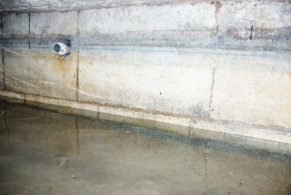 In the kitchen, a small trap door can be removed and beneath the remains of the bath is revealed. This appears to as Mee (1938) describes; a stone basin twelve feet square with a flight of steps entering the water. I scrambled down into this bath and found it presently to have two stone steps which enter the bath, although bricks built upon these suggest that there may have been more.
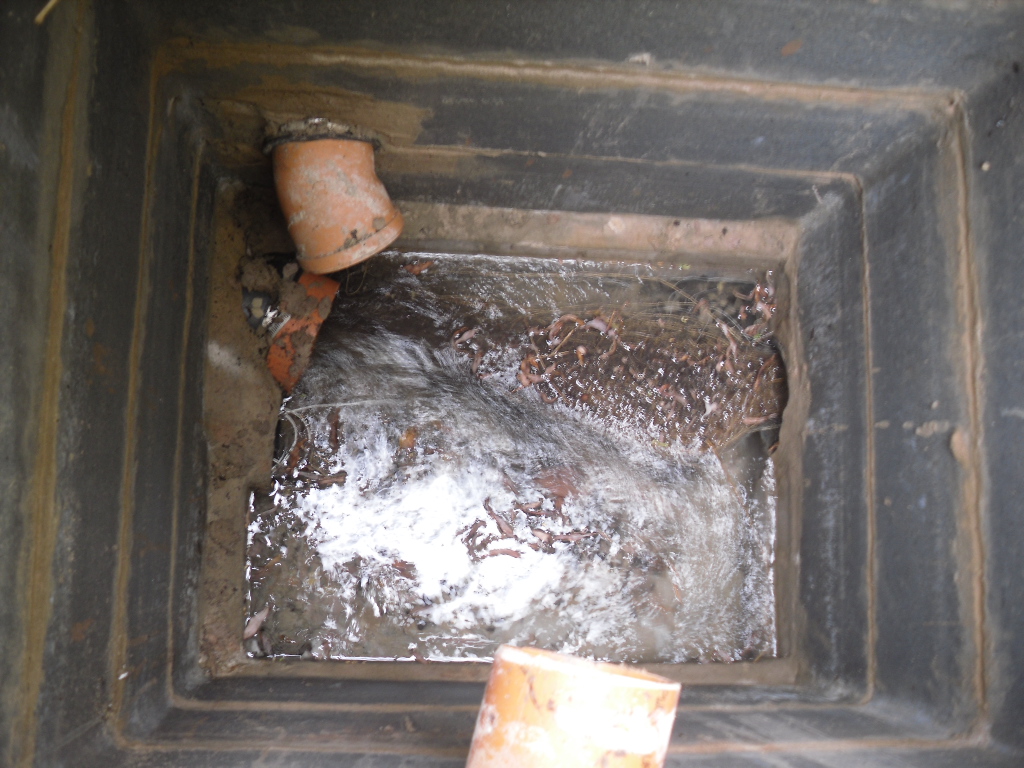 Remarkably the bath still remains enclosing an area fifteen feet by twelve feet, and despite the water being diverted, was full to over a two foot of water. The present kitchen is supported by four brick pillars but this does not appear to have damaged the fabric of the bath which is in fine condition, being made of good quality neat squared stonework. A pipe is found four feet high or so in the wall and a line around it made by the presence of water indicates that the water was of a considerable depth supporting the fact that it was large enough to be a hazard, explaining how Thomas Heald, Vicar of Babworth drowned in it on the 18th June 1759. Mr. Whelan informs me that although the house is not a listed building previous owners had sensibly preserved the bath. Around 30 years ago he was often showing local school children, but it appears now to forgotten. So there it remains a curious relic preserved in its most unusual place.


")

