Hutton Moor Henge, Dishforth, North Yorkshire

Henge:  OS Grid Reference – SE 3525 7351
Getting Here

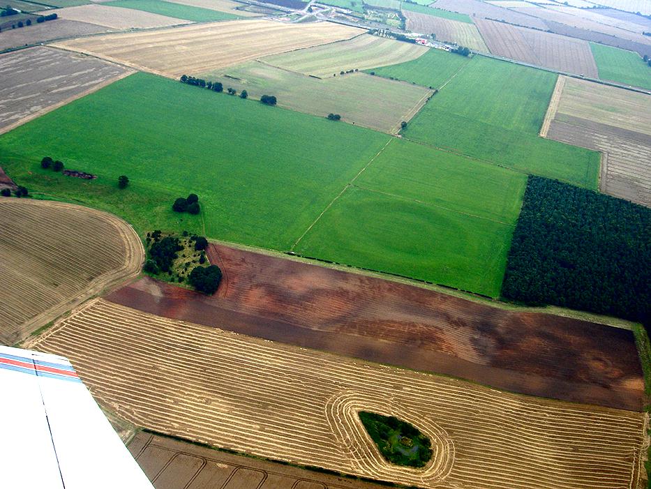
Hutton Moor Henge from above (photo © Pete Glastonbury)

From junction 49 on the A1 (M), Dishforth turn-off, bear west on the Copt Hewick and Ripon road.  100 yards past Copt Hewick, take the track on the right-side of the road, leading to Blois Hall and further up to Low Barn.  Once at Low Barn, go north through the trees called Harland’s Plantation and the barely visible henge remains are in the field on the other side – as PeteG’s fine aerial photo here shows!

Archaeology & History

At ground-level there’s not too much to see of this once fine henge, thanks to the usual excesses of modern agriculture and modern industry.  Which is a pity, as the completed monument here was similar in size and lay-out to the three huge henges a few miles north at Thornborough.  Archaeologist Jan Harding (2003) believes this and the Thornborough henges and others nearby, suggests “there was a unity of purpose behind” all of them, in terms of their lay-out, alignments and ritual purpose.  He may be right.  Aubrey Burl thinks similarly, noting how,

“The central plateau of these enclosures are remarkably similar in shape and size, slightly ovoid and varying no more than 5 metres or so from a norm of 97 by 92 metres.  All have their entrances near the northwest and southeast following the lie of the land.

Each of them could have held as many as two thousand people and yet they crowd together in a narrow rectangle 11km (7 miles) long and no more than 1.5km (1 mile) across, like an avenue of architect-designed houses with a river frontage to their west.”

Intriguing stuff – and all from the neolithic period.  But focussing on Hutton Moor’s monument, …

In Walbran’s (1851) historical work on Ripon and district, he gave us one of the earliest descriptions of Hutton Moor’s henge, telling:

“we have far more direct and conclusive evidence, that the immediate vicinity of Ripon was regarded with peculiar interest and veneration ; since one of the tribes of the Brigantian Celts had chosen it as their station for the dispensation of justice and the celebration of religious rites ; in fact, had made it the seat of their government. This position — novel as it may be — is, I believe, sufficiently proved.by a remarkable earth-work on the high land near ” Blows Hall,” commanding extensive prospects up and down the Vale of Ure, as well as of the distant ranges of hills which form the side screens of the great Yorkshire plain. Like Abury and Stonehenge, which it rivals in antiquity, its outline is that of a circle, of which the diameter is not less than 680 feet ; but no stones remain, nor indeed does that material seem to have been used in its formation. Though recent agricultural operations have partially effaced the regularity and proportion of its plan, it is sufficiently evident that it was enclosed by a lofty mound and corresponding trench — the latter being inside, and a platform or space about thirty feet wide intervening.

“…At two opposite points, bearing nearly north and south, the mound and trench, for about the space of twenty-five feet, have been discontinued, in order to form an approach to the area of the temple. Outside the mound, also, are some slight vestiges of a further avenue, but too indefinite to be traced. But, however obscure the denotation of its several parts may have become, the antiquity and purpose of the place, as a temple for the performance of Druidical rites, is satisfactorily ascertained by the existence of at least eight large Celtic barrows in its immediate vicinity ; one of which, being on the very ridge of the vale, and planted with fir trees, forms a conspicuous and useful object to guide a stranger to the site. Two of these barrows were opened five years ago, but I found nothing but a few calcined human bones, the ashes of the oaken funeral pile, and some fragments of flint arrow-heads, such as are still used by the North-American Indians. Several bronze spear-heads and celts have, however, been found in the neighbourhood, within recollection.”

Walbran also described there being some upright stones at the henge:

“two small pyramids or obelisks, built on the mound of the temple, about fifty years ago, in the place, it is said, of two similar erections, apparently of high antiquity.”

Loveday (1998) addressed some interesting notes about potential alignment features at henges first described in Anthony Harding’s (1987) text, Hutton Moor included — i.e., the angle of their respective entrances/exits very closely mirror the alignment of adjacent Roman roads.  Curious correlates akin to the ley hunter’s assertions find the alignment or direction of nearby Roman roads is echoed in the alignments of henge entrances.  Now this wouldn’t seem too unusual, but in 4 out of 5 henges, this peculiar parallel has been found.  The Hutton Moor henge is no exception; with its aligned entrances closely paralleling the ancient straight Roman road of the A1 (though there are evidences of a pre-Roman track preceding the Roman construction), less than a mile to the east.  The same alignment is echoed in all of the Ure Valley henges.

Folklore
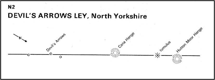
Ley alignment at Hutton henge

This is a site that seems to have been laid out in some form of linear arrangement in prehistoric times.  The notion was first posited in Norrie Ward’s (1969) work, but later expanded in Devereux & Thomson’s (1979) survey of prehistoric alignments.  Although the axis of the henge doesn’t line up with other sites surveyed, they include it in what’s known as the “Devil’s Arrow’s Ley” and the western side of the henge lines up with the Devil’s Arrows and other sites along the line.  When this ley was assessed for statistical probability, Robert Forrest found the alignment to have a probability much greater than that of chance.

References:

  1. Atkinson, R.J.C., “The Henge Monuments of Great Britain,” in Atkinson, Piggott & Sandars’ Excavations at Dorchester, Oxon, Ashmolean Museum 1951.
  2. Burl, Aubrey, Prehistoric Henges, Shire: Princes Risborough 1997.
  3. Devereux, Paul & Thomson, Ian, The Ley Hunter’s Companion, Thames & Hudson: London 1979.
  4. Harding, Anthony F. & Lee, G.E., Henge Monuments and Related Sites of Great Britain, BAR 175: Oxford 1987.
  5. Harding, Jan, Henge Monuments of the British Isles, Tempus: Stroud 2003.
  6. Loveday, Roy, “Double Entrance Henges”, in Prehistoric Ritual and Religion, Sutton: Stroud 1998.
  7. Walbran, John Richard, A Guide to Ripon, Harrogate, Fountains Abbey, Bolton Priory, W. Harrison: Ripon 1851.

Acknowledgements:

Huge thanks to Paul Devereux for use of his ley alignment drawing.

© Paul Bennett, The Northern Antiquarian 


Claymore Well, Kettleness, North Yorkshire

Sacred Well:  OS Grid Reference – NZ 819 148

Folklore

In this region so full of old tombs and prehistoric remains, we find this little-known sacred well, long since known as a place of curious sprites and strange lore.  Elizabeth Wright (1913) said of the place,

“It is said that the fairies were wont of old to wash their clothes in Claymore Well, and mangle them with the bittle and pin.  The bittle is a heavy wooden battledore; the pin is the roller; the linen is wound round the latter, and then reolled backwards and forwards on the table by pressure on the battledore.  The strokes of the bittles on fairy washing-nights could be heard a mile away.”

A most curious tale…

References:

  1. Wright, Elizabeth Mary, Rustic Speech and Folk-lore, Oxford University Press 1913.

© Paul Bennett, The Northern Antiquarian

Old Woman’s Well, Guisborough, North Yorkshire

Holy Well (lost): OS Grid Reference – NZ 610 180

Getting Here

The grid reference here is an approximation, but the old well was definitely somewhere very close by, as evidenced by the place-name of the farmhouse. But if you wanna get here and wander about in the hope that you can re-locate this once sacred water source, go up the B1269 road north of Guisborough for about a mile. Carling Howe farmhouse is on the left-hand side of the road. Obviously the old well is somewhere close by…

Archaeology & History

The information I have of this site comes from old place-name listings. I found the reference in the directory for North Yorkshire by A.H. Smith (1928), in his entry for the etymology of ‘Carling Howe’ at Guisborough.  Smith ascribes the references of ‘Kerlinghou’ (which itself appears to have been lost) to mean the ‘Old woman’s mound’ and variants thereof, also saying, “There is an unidentified place in this township called Kerlingkelde,” (12th century ref. Guisborough Cartulary)—the ‘Old Woman’s Well’.  Very commonly in this part of Yorkshire—as at many other locations in northern England—a hou or howe (and variants thereof) relates to a prehistoric tomb – which is probably what we had here: a prehistoric Old Woman’s Grave with an associated Old Woman’s Well in close attendance.

The ‘old woman’ element in this name very probably relates to that primal mythic deity, the cailleach, the great prima mater of indigenous heathen folk, beloved mainly in Scottish and Irish lore, where her copious name and tales resonate to this day. This “well of the Old Woman, or cailleach“, would have been a place of particular importance in the mythic cosmology of our ancestors, but its precise whereabouts seems forgotten. There is a plentiful supply of water around Carling Howe Farm, one or more of which may once have been the site of this well. However, a lot of quarrying operations occurred here in the not-too-distant past, and this may have irreparably damaged our ability to accurately find the site – though perhaps a perusal of old field-maps could be productive.

It would also be good if we could locate the original whereabouts of the old tomb here which gave the place its name – the ‘Carling Howe’.  Other ‘howe’ sites in East and North Yorkshire turn out to be prehistoric burials and I have little doubt that the same occurred here.

References:

  1. o’ Crualaoich, Gearoid, The Book of the Cailleach, Cork University Press 2003.
  2. Smith, A.H., The Place-Names of the North Riding of Yorkshire, Cambridge University Press 1928.

© Paul Bennett, The Northern Antiquarian

Woman Stone, Askwith Moor, North Yorkshire

Cup-and-Ring Stone:  OS Grid Reference – SE 17103 50541

Also Known as:

  1. Carving no.520 (Boughey & Vickerman)

Getting Here

Takes a bit of finding this – but if you like your rock art, it’s worth the search!  You can follow directions for the getting to the Man Stone then, when you reach it, look to the near horizon to the east.  Get to the bottom of the sloping hillside where a large rounded boulder sits and walk up the slope about 10 yards.  Look around here cos you’re very close.

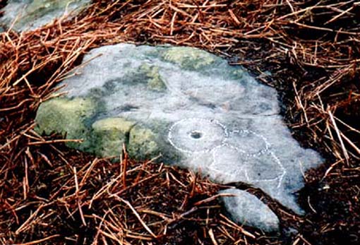
Woman Stone carving
Carving highlighted in chalk

Alternatively, from the Askwith Moor Road, follow the path to the triangulation pillar on Shooting House Hill.  Keep going for another 100 yards and check a small path to your left (south).  Follow this down until you get to the top of the slope.  Go to the bottom of the slope and look around!

This carving is best checked out in winter and early spring: if you go here in summer & autumn there’s bracken covering the entire site & you’ll never find it!

Archaeology & History

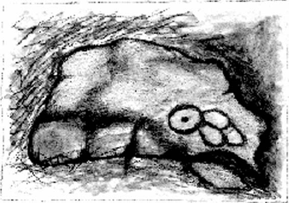
Drawing by Inmaculada Ibanez-Sanchez

This stone was first discovered by Graeme Chappell and I during one of our many ambling explorations here in the early 1990s and was first mentioned in my Old Stones of Elmet (pp.149-152).  Marija Gimbutas would have loved this seemingly matriarchal-looking cup-and-ring carving, suggestive of many Mother Goddess images she found across Europe – hence its title!

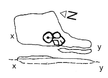
Woman Stone design (after Boughey & Vickerman)

I don’t think that the old-school archaeological types would lower themselves to say such a thing, but as I aint one of them I’m quite confident in saying that this carving does seem to be a pictorial representation of a female figure: one of the earliest of its kind in the British Isles? (check its nearby male compatriot, the Man Stone – a distinctly human figure and one of the earliest of its kind in the British Isles)  Very close by we are left with old place-name remnants pointing directly at the presence of pre-christian goddess remains in the mythic landscape – an issue I’ll expand on in the near future.

In the survey by more recent rock art students Boughey & Vickerman (2003), their illustration of the carving makes it look even more like an early female figure! (though I hear they don’t like people giving the carvings names – unless, of course, one of them lot names it…)

References:

  1. Bennett, Paul, The Old Stones of Elmet, Capall Bann: Milverton 2001.
  2. Boughey, Keith & Vickerman, E.A., Prehistoric Rock Art of the West Riding, WYAS: Wakefield 2003.
  3. Gimbutas, Marija, The Language of the Goddess, Harper-Collins: San Francisco 1989.
  4. Gimbutas, Marija, The Civilization of the Goddess: The World of Old Europe, Harper-Collins: San Franciscoo 1991.

© Paul Bennett, The Northern Antiquarian

Walton Head, Kirkby Overblow, North Yorkshire

Standing Stone:  OS Grid Reference – SE 30335 49907

Getting Here

Along the A61 Harrogate-to-Harewood road, just below the roundabout where the A658 links up, is a small country road that turns towards the lovely village of Kirkby Overblow.  If you’re in a car, park up wherever you can hereabouts (being careful of the locals!).  Cross over onto the western-side of the A61 and walk along the small tree-lined field-edge until you find a spot to get over, where this stone stands.

Archaeology & History

It’s hard to suss out how many monoliths first stood here, but when William Grainge (1871) and Harry Speight (1903) described them, it was believed they had been uprooted in the 17th or 18th century.  Although one of them has gone, thankfully the scarred remnant of one is still here.

Site number 168 in Old Stones of Elmet, one of the two standing stones that were described in parish boundary records of 1577 as “two stones standing in Walton Head Layne” can be found northeast of the village, along the ancient church way between Rigton and Kirkby.  However, it is not as it once was! The boundary perambulation was redefined in 1767, when it was thought that a new monolith had been erected to replace the site of the old ones; but it turns out that some masons simply smoothed off the old stone and carved ‘K.F. 1767’ onto one of the original two. If you look at the base of the stone (which is more than 4 feet tall, leaning slightly to one side), it’s obvious that it’s been in the ground for one helluva long time. Much much longer than any old 1767 – or 1577 for that matter!  What we appear to have here is simply a worked remnant of a true prehistoric standing stone.

References:

  1. Grainge, William, The History and Topography of Harrogate and the Forest of Knaresborough, John Russell Smith: London 1871.
  2. Speight, Harry, Kirkby Overblow and District, Elliott Stock: London 1903.

© Paul Bennett, The Northern Antiquarian

Stanwick Fortifications, North Yorkshire

Settlement:  OS Grid Reference – NZ 1783 1229

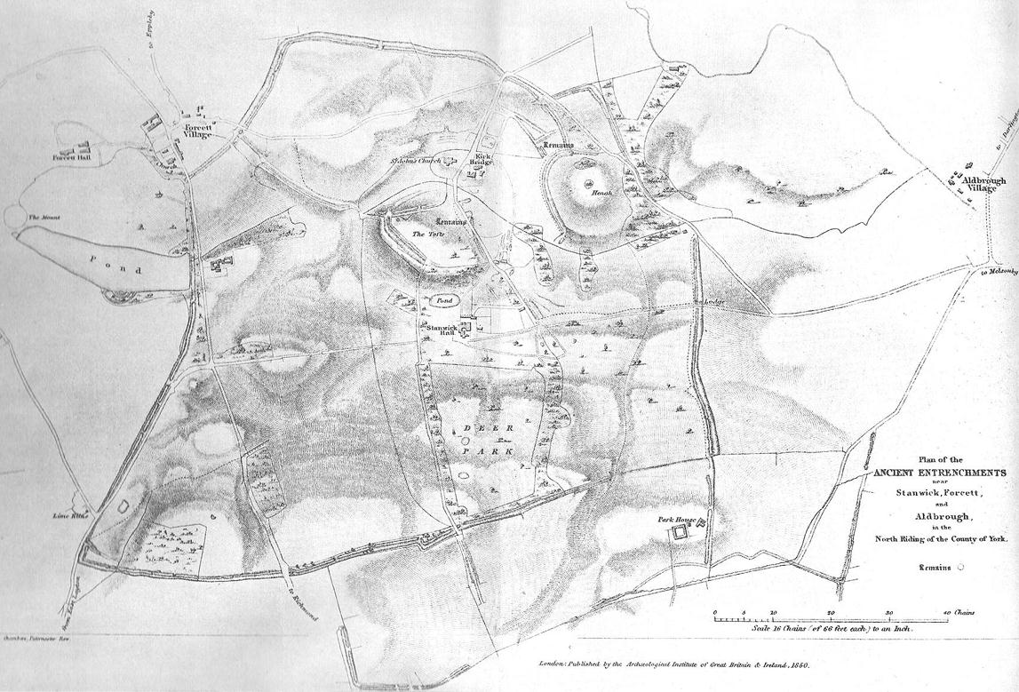
1850 map of village & earthworks

Getting Here

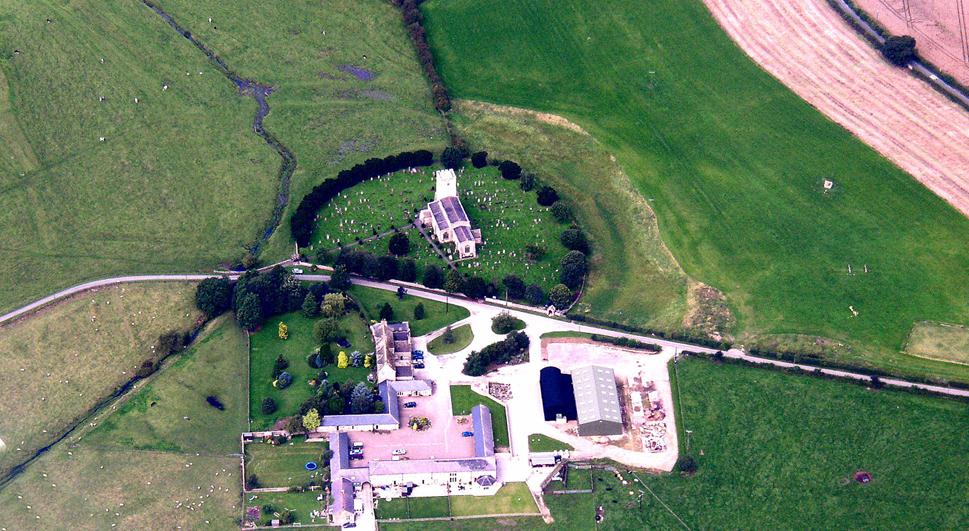
From Scotch Corner on the A1, head on the A66 and take the first right up to and straight thru Melsonby village at the crossroads and on for a few more miles till you hit the hamlet of Stanwick-St.-John.  You’re now in the middle of the fortifications and earthworks! (check the map, right) Get to the nearby church of St. John’s and you’re on what once could have been a henge.

Archaeology & History

Although the Roman’s came here, the origins of this huge enclosure and settlement — between the hamlets of Eppleby and Stanwick St. John — are at least Iron Age.  It’s very probable that this place has been used by people since at least the Bronze Age, if not earlier — but let’s keep to playing safe (for a change) and repeat what the professionals have found!  Stanwick was recorded in Domesday as Stenwege and Steinwege, which A.H. Smith (1928) and later etymologists tell us means “stone walls,” which obviously relates “to some ancient rock entrenchments found in the township”, or the Stanwick Fortifications no less!

Sir Mortimer Wheeler’s (1954) account of the history and excavation of these huge ramparts found that it was a centre of some importance to the Brigantians. His view was that it was the rebel stronghold of the Brigantian figure called Venutius, ex-partner of the Queen Cartimandua.  Archaeologists who did further work here in the 1980s concluded that it was one of Cartimandua’s “estates” — possibly even the original capital city of Brigantia.

Church on the circular henge-like remains (phot courtesy Pete Glastonbury)
Church on the henge-like remains (photo © Pete Glastonbury)

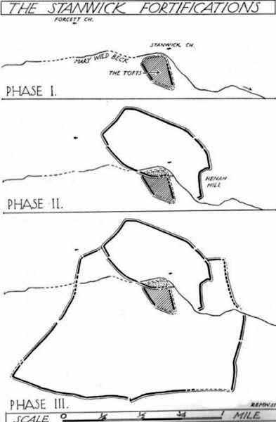
The settlement was enlarged and fortified considerably upon the arrival of the Romans in the first century. Splitting them into three phases, the earliest Phase I area (Iron Age) covered 17-acres; Phase II was extended over 130 acres; and Phase 3 extended the enclosure over another 600 acres.  A further extension of earthworks appears to have occurred, but Wheeler believed them to have been constructed at a much later period.  To allow for a decent discourse on this huge site and its multiperiod settlement, I’m gonna quote extensively Mr Wheeler’s (1954) text on the site, who headed a team of archaeologists in the summers of 1951 and 1952 and explored various sections of this huge arena.

In the introduction to his work, Mortimer briefly mentioned the finding of some chariot burials found close by, though less certain is the exact spot where these important remains came from.  He wrote:

“Of the three accounts, the earliest, dating from shortly after the discovery, states that the objects ‘were deposited together in a pit at a depth of about five feet within the entrenchment at Stanwick.  Near by large iron hoops were found.’  Two years later MacLauchlan showed the find-spot on his map…as a little to the northeast of Lower Langdale, well outside the main Stanwick earthworks, and, in spite of variant accounts, his evidence may be regarded as authoritative.”

Nothing more is said of these finds throughout the book.  Instead, Mortimer guides us through their dig, beginning with the structural sequence of the extensive earthworks that constitute Stanwick’s fortifications, from Phase 1 onwards, saying:

Plan showing 3-phase evolution of Stanwick earthworks from the Iron Age period at the top, to Phase 3 works in the 1st century AD (from Wheeler’s ‘Stanwick Fortifications’, 1954)

Phase I.  The nucleus of the whole system is a fortified enclosure, some 17 acres in extent, situated to the south of Stanwick Church and the Mary Wild beck, on and around a low hill known as ‘The Tofts’… The name ‘Tofts’ is defined by the Oxford Dictionary as “Site of a homestead”, or “An eminence, knoll or hillock in a flat region; esp. one suitable for the site of a house.”  Appropriately the field is described by the farmer as a ‘dirty’ one; it produces an abundant crop of nettles which have to be cut twice a year and are a common sequel to ancient occupation.  The enclosure is, or rather was, roughly triangular on plan, conforming approximately with the mild contours of the hill and to that extent meriting the exaggerated designation of ‘hill-fort.’  On the west its rampart and ditch are excellently preserved in a stretch of plantation known as ‘The Terrace’ or ‘The Duchess’s Walk’, where the single bank of unrevetted earthwork rises some 24ft above the ditch… The southern corner has been almost completely obliterated, but a part of it can be traced faintly in the walled garden southeast of the The Terrace.  A stretch of the eastern side still stands up boldly beside the road from Stanwick Church to (the former) Stanwick Hall, but a large part of this side has been demolished for the making of the road, and some dumps of earth immediately east of Church Lodge may be a result of this process.  The northern side approached but stopped short of the brook, and is marked by remains of a counterscarp bank… The main rampart was here thrown into the ditch anciently, doubtless when this portion of the work was included in and superseded by the work of Phase II.  Near the northwestern corner was a stone-flanked entrance, now partially obscured by the northern end-wall of the Terrace plantation.  The rampart was of earth, apparently without stone or timber revetment, the ditch was V-shaped save where, on the northern or lowest side, its completion in depth was stopped by water and the counterscarp bank already referred to was added as compensation.

Phase II.  Subsequently, at a moment which will be defined in the sequel as not later than AD 60, the hill-fort was supplemented by a new enclosure over 130 acres in extent, so designed as to outline the slight ridge north of the brook, to bend inward round the nearer foot of Henah Hill on the east, and farther west to cut off the northern end of the hill-fort, obviously in order to enclose the brook and its margin hereabouts.  Southeast of Stanwick Church, the marshy course of the brook for a distance of over 300 yards was regarded as a sufficient obstacle, without rampart and ditch, though whether supplemented by a palisade is not known.  As already indicated, that part of the Phase I earthwork which now lay inside the new enclosure was largely obliterated by filling its rampart into its ditch.

The enclosure constituting Phase II had an entrance near its western corner…where 50ft of the ditch, partially rock-cut, were cleared with notable results… There may have been another entrance under the present road-junction immediately east of the Stanwick vicarage, in the middle of the northern side, or less probably, at an existing gap 150 yards further to the southeast.  The rampart was of earth, aligned initially at the back on a small marking-out trench and bank; in front it was revetted with a vertical drystone wall.  The ditch was cut in the boulder-clay and partially in the underlying limestone…

Phase III.  At a date which will be defined as about a dozen years later (c. AD 72), a similar though longer system, enclosing a further 600 acres, was added to Phase II.  It impinges almost at a right angle upon, and implies the pre-existence of, Phase II on the east, and terminates upon the ditch of Phase II on the west.  An entrance can be seen near the middle of the southern side, and less certainly a gap in Forcett Park may represent a second entrance in the western side.  Further stretches of the mary Wild beck were included. The rampart, like that of Site A, incorporated a marking-out trench and bank at the rear, and was fronted with a vertical stone revetment.

Phase IV.  To the southern side of Phase III was added at an unknown period an enclosure of some 100 acres, now subdivided by traces of a double earthwork extending southwards from a point east  of the southern entrance of Phase III… This double earthwork however, is of an entirely different character from those already considered, and appears indeed to overlap the rampart of Phase III at a point where the latter had already been broken through.  It is comparable with some of the double banks which constitute or are incorporated in the Scots Dike at Lower Langdale, farther east; and the Phase IV enclosure is in fact linked with the Scots Dike by a semi-obliterated ditch extending eastwards from its southeastern corner.  Phase IV…may, as has been suspected, relate to the Anglo-Saxon period.”

References:

  1. Smith, A.H., The Place-Names of the North Riding of Yorkshire, Cambridge University Press 1928.
  2. Wheeler, Mortimer, ‘The Stanwick Excavations, 1951,’ in Antiquaries Journal, January 1952.
  3. The Stanwick Fortifications, North Riding of Yorkshire, OUP & Society of Antiquaries: London 1954.

Links: – Stanwick Iron Age Hillfort – For an extensive overview of the archaeology of this large site, you can do no better than this web-page.

© Paul Bennett, The Northern Antiquarian

Snowden Carr Carving (594), Timble, North Yorkshire

Cup-and-Ring Stone:  OS Grid Reference – SE 17903 51266

Also Known as:

  1. Fence Stone

Getting Here

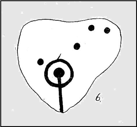
Carving 594 (after James Elkington)

Follow the same directions to reach the Tree of Life Stone, then walk up the well-worn footpath up the slope for about 100 yards and, as you get to near the top of the hill, just watch out for a large-ish stone on the right.  That’s it!

Archaeology & History

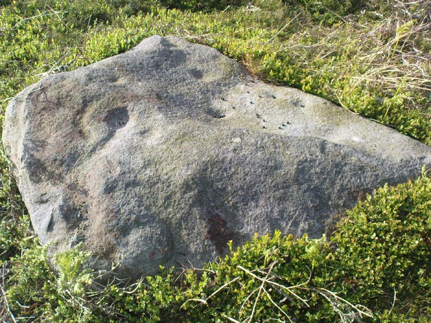
First described by Eric Cowling 1937, here we have what here looks like a faded cup-and-ring plus at least eight other cup-markings near Snowden Crags (though Boughey & Vickerman [2003] counted only 6 cups here).  In more recent years it has become known as the “Fence Stone” due to its proximity the straight line of fencing which ran across the moor hereby.  Cowling’s description of the site told:

Faded cup-and-ring
Cowling’s 1937 drawing

“The spur of hill separating Snowden Carr from Snowden Craggs is surmounted by a D-shaped enclosure which has a small level area in the highest corner.  Here, on a triangular table stone amongst the heather, is a well-cut cup, ring and radial groove running to the margin of the surface.  Four other cups appear to have no definite arrangement.”

He went onto say that “many of the boulders which surround this table are marked with cups.”  They are indeed!

References:

  1. Boughey, Keith & Vickerman, E.A., Prehistoric Rock Art of the West Riding, WYAS 2003.
  2. Cowling, Eric T., “Cup and Ring Markings to the North of Otley,” in Yorkshire Archaeological Journal, part 131, 33:3, 1937.
  3. Cowling, Eric T., Rombald’s Way: A Prehistory of Mid-Wharfedale, William Walker: Otley 1946.

Acknowledgements:  A huge thanks to James Elkington for use of his photo for this site profile.

© Paul Bennett, The Northern Antiquarian

Skirtful of Stones, Horton-in-Ribblesdale, North Yorkshire

Cairn (destroyed):  OS Grid Reference – SD 785 747

Getting Here

Although apparently long gone, we could find this giant prehistoric tomb on the eastern side of the great Ingleborough and was one of many with this name once scattering the mid-Pennines. It was found less than a mile south of the hamlet of Selside, a few miles above Horton-in-Ribblesdale, on the west side of the B6479 and its existence is thankfully preserved in the place-name, ‘Borrens’, where the giant tomb was once found, 200 yards south of Gill Garth Farm.  If you look on the OS-map, you’ll notice an ancient settlement site close by.

Archaeology & History

In 1892, the great Yorkshire historian Harry Speight told us:

“We have no proper account of it, but it was doubtless ransacked and removed in the expectation of finding treasure. It is mentioned…in the Gentleman’s Magazine for 1761, as follows:

‘In the valley above Horton, near the base of this mountain (Ingleborough), I observed a large heap or pile of greet-stones all thrown promiscuously together, without any appearance of building or workmanship, which yet cannot be reasonably thought to be the work of Nature. Few stones are found near it, though ’tis computed to contain 400 of that country cart-loads of stones, or upwards. There is likewise another at the base north-east, in resemblance much the same, but scarce so large.'”

Speight speculated that it may have been raised to commemorate “some dire conflict between the Romans and the native hill tribes, as it lay on the old Roman thoroughfare across Ribblehead to the camp under Smearside.” We may never know this for sure, but there are plenty of Iron- and Bronze Age remains scattering this region – and just a few hundred yards south of this lost cairn are the old remnants of an ancient settlement…whose pages and images (it is hoped) will appear on TNA in the near future…

References:

  1. Smith, A.H., English Place-Name Elements, volume 1, Cambridge University Press 1956.
  2. Smith, A.H., Place-Names of the West Riding, volume 6, Cambridge University Press 1961.
  3. Speight, Harry, The Craven and Northwest Yorkshire Highlands, Elliott Stock: London 1892.

© Paul BennettThe Northern Antiquarian 


Simon’s Seat, Skyreholme, North Yorkshire

Sacred Hill:  OS Grid Reference – SE 0788 5981

Getting Here

Simon’s Seat in the centre & the Lord’s Seat immediately east

Tons of ways here.   To those who drive, take the Grassington-Pateley Bridge (B6265) road and a couple of miles past the village of Hebden, you’ll see the high rocks climbing on your southern horizon, with another group of rocks a few hundred yards along the same ridge.  That’s it!

Archaeology & History

This is an awesome site, full of raw power. It commands a brilliant view all round, but it is the north which truly draws the eye’s attention. Beneath the great drop of this huge outcrop is the haunted and legendary Troller’s Ghyll. The scent of as yet undisclosed neolithic and Bronze Age sites purrs from the moors all round you and there can be little doubt that this was a place of important magick in ancient days.

What seems to be several cup-markings on one of the topmost rocks are, to me, authentic. Harry Speight mentioned them in his 1892 work on the Craven and Northwest Yorkshire Highlands – but there are a number of other rocks in this giant outcrop with “possibles” on them.

Folklore

The name of this great rock outcrop has long been a puzzle to historians and place-name experts.  One tale that was told of Simon’s Seat to the travelling pen of one Frederic Montagu in 1838, told that,

“It was upon the top of this mountain that an infant was found by a shepherd, who took it to his home, and after feeding and clothing it, he had the child named Simon; being himself but a poor man, he was unable to maintain the foundling, when it was ultimately agreed to by the shepherds, that the child should be kept “amang ’em.”  The child was called Simon Amangham and the descendants of this child are now living in Wharfedale.”

The usually sober pen of Mr Speight thinks this to have been one the high places of druidic worship, named after the legendary Simon Druid. “It is however, hardly likely,” he wrote, “that he ever sat there himself, but was probably represented by some druidical soothsayer on whom his mystic gifts descended.”

I’ve gotta say, I think there’s something distinctly true about those lines. Visit this place a few times, alone, during the week, or at night – when there’s no tourists about – and tell me it isn’t…

References:

  1. Bogg, Edmund, Higher Wharfeland, James Miles: Leeds 1904.
  2. Montagu, Frederic, Gleanings in Craven, Simpkin Marshall: London 1838.
  3. Speight, Harry, The Craven and Northwest Yorkshire Highlands, Elliott Stock: London 1892.

© Paul Bennett, The Northern Antiquarian


Scale House, Rylstone, North Yorkshire

Tumulus:  OS Grid Reference – SD 97088 56870

Getting Here

Pretty simple really.  Go up the B6265 Skipton-Rylstone road for about 3 miles, past the Nettlehole Ridge woodland on your right.  The next turn along to your right, up the track, is Scale House.  Go past this until you get to Scale House Farm.  The remains of the burial mound is in the field to your left, just before the farm.  Knock on the door and ask!

Archaeology & History

This ‘tumulus’ (as it’s marked on the OS-map) was one of the many explored by the legendary reverend William Greenwell (1864) in the middle to latter-half of the 19th century.  His description of the finds at Scale House were considerable; thankfully our old Yorkshire antiquarian Edmund Bogg (1904) shortened it and told us the following:

“The tumulus was 31 feet in diameter and about 7 feet high; it opened from the southeast; the soil immediately under the sod consisting of yellow clay to a considerable depth; then layers of blue clay… Exactly in the centre…at a depth of 7 feet, and on a level with the plane of the field, was found an oak coffin, formed out of a tree, split and hollowed-out, and placed due north and south, the head being placed to the south, as that as the larger part of the tree. After being exposed to the air for about 2 minutes, the bared coffin parted at the sides, and could not be moved except by detached pieces. The body had been wrapped in a cloth or shroud of texture resembling wool and coarsely-woven, of which there was a considerable quantity remaining; but the body itself was dissolved… The interment was considered to be that of an ancient Briton… The learned antiquary said it was the only instance (except the one at Gristhorpe, near Scarborough) where an interment in an oak tree hollowed out had a tumulus placed over it. It was more than 6 feet in length inside and about 7 feet 6 inches outside. The remains were carefully replaced and the mound restored to its former shape; a small leaden tablet being placed within, stating that it had been opened in AD 1864.”

Folklore

Jessica Lofthouse (1976) listed this as one of the places reputed to be an old fairy haunt, wherein “the folk of Scale House discovered a fairy kist or chest.”

References:

  1. Bogg, Edmund, Higher Wharfeland, James Miles: Leeds 1904.
  2. Greenwell, William, British Barrows, Clarendon Press: Oxford 1877.
  3. Lofthouse, Jessica, North Country Folklore, Hale: London 1976.

Links:

  1. Out of Oblivion: Archaeology and Notes – Directions and notices on this once giant tomb.

© Paul Bennett, The Northern Antiquarian