Follow the directions to reach the Snowden Moor settlement and, from the Upper D-shaped enclosure (at SE 1782 5131) walk west up the sloped hillock 30 yards west and, on its top, head to its northern edge where a small cairn can be found. The carving is next to it.
Archaeology & History
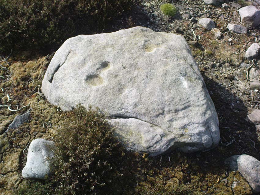
Very close to what seems to be the boundary between the Snowden Moor Settlement and its adjacent Cemetery is this small earthfast rock with three cup-markings on it, two of which may be linked by a small line. I have to say that we have to be cautious about the veracity of this carving. By the side of this stone is what seems to be the remains of a cairn.
References:
Boughey, Keith & Vickerman, E.A., Prehistoric Rock Art of the West Riding, WYAS: Wakefield 2003.
From Threshfield, go up Skirethorns Lane for about 1/2 mile, where the lane takes a sharp right. Continue uphill for nearly 2 miles to a metal gate. Go through the gate, where you’ll see a pair of curious standing stones ahead of you, but instead walk about 250 yards along the line of the old field wall running to the west. You’ll see on the modern OS-map that a ‘cairn’ is shown: this is where you’re heading!
Archaeology & History
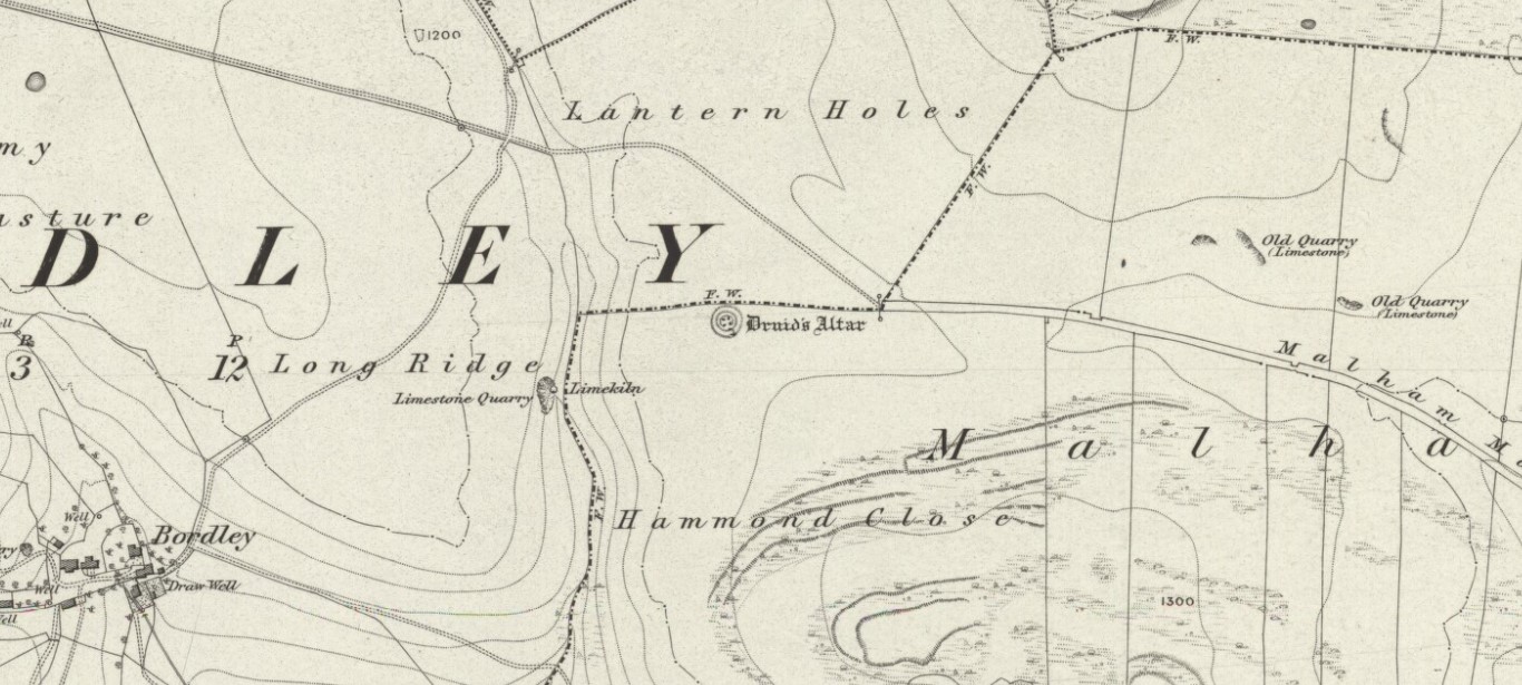
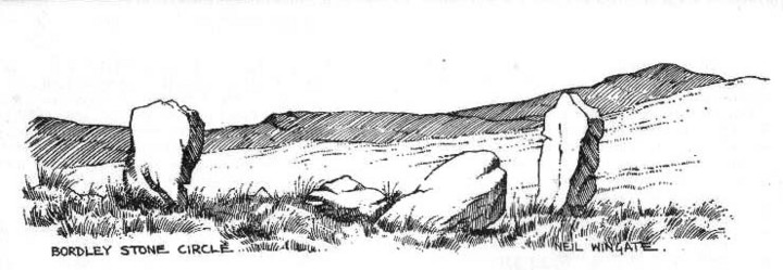
First highlighted on the 1852 OS-map of Bordley and district, this is a lovely site in a beautiful setting, surrounded by a veritable mass of other prehistoric remains at all quarters, including the large settlement of Hammond Close immediately south, the little-known settlement at Kealcup to the west, the Lantern Holes settlement up the hill immediately north, some standing stones due east, and much more. Although it was described in Aubrey Burl’s Four Posters (1988) as just such a type of megalithic relic (a “four-poster stone circle”), an earlier description of the site from the mighty pen of Harry Speight (1892) told of a much more complete ring of stones, with trilithon to boot. He wrote:
“This prehistoric relic consists of a round stone and earthen mound, about 150 feet in circumference and 3 feet high, and was formerly surrounded by a circle of upright stones, only three of which are now left standing. On one side was a large flat stone resting upon two others, and known as the Druid’s Altar. On the adjoining land an ancient iron spear-head was found some years ago, and fragments of rudely-fashioned pottery have also from time to time turned up in the same neighbourhood.”
Edmund Bogg’s (1904) description following his own visit a few years later described this “remains of Druidical sacrifice” as consisting of,
“a mound some four feet high, and fifty yards round the outer rim. In the centre are two upright stones about four feet in length; and others nearly buried in the mound. Numerous stones from this circle have been used in building the adjoining walls.”
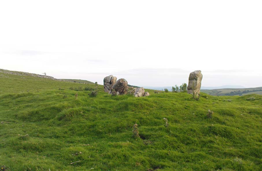
Bordley Circle, looking SEBordley Hill, looking south to Pendle Hill
A decade later another writer (Lewis 1914) merely copied what Speight and Bogg had recited previously. And whatever the modern books might tell of its status, I think we can safely assert that this was originally a much more substantial monument than the humble four-poster stone circle that meets our eye nowadays. Our megalithic magus, Aubrey Burl (1988), wrote the following on Bordley’s druidical stones:
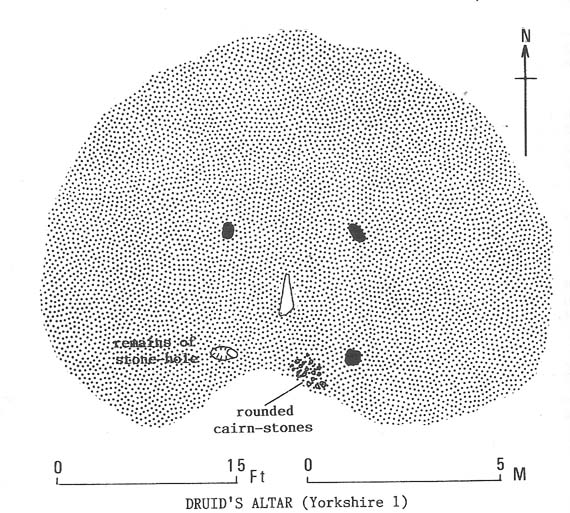
“On a circular mound 41ft (12.5m) across and 3ft (1m) high, three stones of local limestone form the corners of a rectangle 11ft 6in (3.5m) square, from which the SW stone is missing. At its corner is ‘a stump, possibly the base of a prostrate stone,’ 5ft 10in (1.8m) long, now lying near the centre. The tallest stone, 3ft 7in (1.1m) high is at the south-east. The sides of the square are close to the cardinal points. Between the SW and SE stones is a scatter of round cairnstones… Characteristically, the 4-Poster stands at the edge of a terrace from which the lands falls steeply to the west.”
Plan of the Druid’s Altar (after Burl, 1988)
The Druid’s Altar seems to have originally been a large prehistoric tomb, perhaps even a chambered cairn. Its situation in the landscape where it holds a circle of many outlying hills to attention, almost in the centre of them all, was evidently of some importance. The only geographical ‘opening’ from here is to the south, where a long open valley widens to capture the grandeur of Pendle Hill, many miles away. This would not have been insignificant.
We must also draw attention to what may be a secondary tumulus of similar size and form to the mound that the Druid’s Altar sits upon only some 25 yards to the west of the “circle”. The shape and form of this second mound is similar to that of our Druid’s Circle — though to date, it seems that no archaeologist has paid attention to this secondary feature. It measures some 21 yards (east-west) x 19 yards (north-south) in diameter and has the appearance of a tumulus or buried cairn. The mound may be of a purely geological nature, but this cannot safely be asserted until the attention of the spade has been brought here.
Druid’s Altar, Bordley (drawing by Neil Wingate, 1976)
Folklore
Although we have nothing directly associated with the circle, the surrounding hills here have long been known as the abode of faerie-folk. Threshfield — in whose parish this circle lies — is renowned for it. There have been accounts of curious light phenomena here too. Modern alignment lore tells the site to be related to the peaked tomb above Seaty Hill, equinox west of here.
References:
Bogg, Edmund, Higher Wharfeland, James Miles: Otley 1904.
Burl, Aubrey, Four Posters: Bronze Age Stone Circles of Western Europe, BAR 195: Oxford 1988.
Feather, S.W. & Manby, T.G., ‘Prehistoric Chambered Tombs of the Pennines,’ in Yorkshire Archaeological Journal, Vol 42, 1970.
Lewis, A.L., ‘Standing Stones and Stone Circles in Yorkshire,’ in Man, no.83, 1914.
Raistrick, Arthur, ‘The Bronze Age in West Yorkshire,’ in Yorkshire Archaeological Journal, Vol 29, 1929.
Speight, Harry, The Craven and Northwest Yorkshire Highlands, Elliott Stock: London 1892.
Wingate, Neil, Grassington and Wharfedale, Grassington 1977.
Found near the bottom of Holly Hill, as Graeme Chappell tells us, this old site “is located by the side of a narrow lane on the west side of the village of Well (aptly named). The OS map places the well on the north side of the lane, but this is only the outflow from a pipe that carries the water under the road. The spring actually rises at the foot of a small rock outcrop, on the opposite side of the road.”
Archaeology & History
St. Michael’s Well, Well (Bogg 1895)
Although the village of Well is mentioned in Domesday in 1086 and the origin of the place-name derives from “certain springs in the township now known as The Springs, St. Michael’s Well and Whitwell,” very little appears to have been written about this place. Edmund Bogg (c.1895) wrote that an old iron cup — still there in the 19th century — was attached next to this spring for weary travellers or locals to partake of the fine fresh water. Nearby there was once an old Roman bath-house and, at the local church, one writer thinks that the appearance of “a fish-bodied female figure…carved into one of the external window lintels” is representative of the goddess of these waters. Not so sure misself — but I’m willing to be shown otherwise.
Folklore
Around 1895, that old traveller Edmund Bogg once again wrote how the villagers at Well village called this site the Mickey or Mickel Well,* explaining: “the Saxons dwelling at this spot reverently dedicated this spring of water to St. Michael.” A dragon-slayer no less!
Although not realising the Michael/dragon connection, the same writer later goes on to write:
“There is a dim tradition still existing in this village of an enormous dragon having once had its lair in the vicinity of Well, and was a source of terror to the inhabitants, until a champion was found in an ancestor of the Latimers, who went boldly forth like a true knight of olden times, and after a long and terrible fight he slew the monster, hence a dragon on the coat of arms of this family. The scene of the conflict is still pointed out, and is midway between Tanfield and Well.”
This fable occurred very close to the gigantic Thornborough Henges! It would be sensible to look more closely at the mythic nature of this complex with this legend in mind. A few miles away in the village of Kirklington, the cult of St. Michael could also be found.
References:
Bogg, Edmund, From Eden Vale to the Plains of York, James Miles: Leeds n.d. (c.1895)
Smith, A.H., The Place-Names of the North Riding of Yorkshire, Cambridge University Press 1928.
* In old english the word ‘micel‘ (which usually accounts for this word) means big or great. On the same issue, the ‘Holly Hill’ in the case here at Well actually derives from the holly tree and NOT a ‘holy’ well. However, check the folklore of this tree in Britain and you find a whole host of heathen stuff.
Follow the same directions as to reach the Tree of Life Stone carving. From here walk 7 or 8 yards east. You can’t miss it!
Archaeology & History
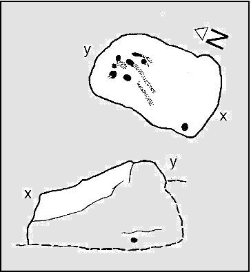
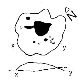
Coped Stone carving (after Boughey & Vickerman)
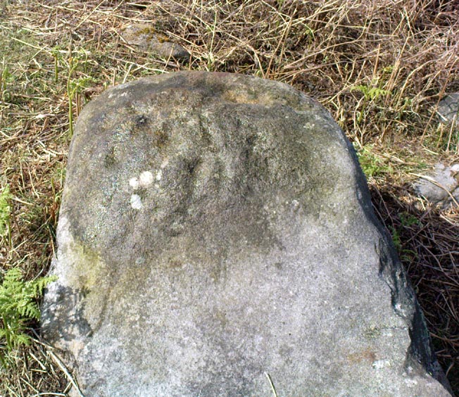
About 20 feet away from the more renowned Tree of Life Stone — and seemingly linked to it by a small stretch of ancient walling that runs between the respective stones — is this rather large boulder close to the walling with at least seven cup-marks on it. A number of vague lines run down and around the edges of some of the cups, but they can be somewhat hard to see if the light conditions aint right (I don’t recommend trying to suss it out on dark grey overcast days — unless you’ve got awesome eyes!). Immediately next to this rock is a large collection of small stones, looking to be the remains of some man-made construction from time past. The nature of this pile of rocks has yet to be ascertained, but it would be reasonable to assume that it was at one point earlier a much larger pile that has been plundered for use to make the drystone walls hereby. Less than 10 yards below this and the Tree of Life Stone carving is a line of ancient walling, at least Iron Age in nature, possibly earlier, running for some distance east-west up and across the moorland.
Cup-marks near top of the stone
The carving was described for the first time, albeit very briefly, by Eric Cowling (1937) in his lengthier description of the Tree of Life Stone, saying how “a small coped stone to the east has several scattered cups” on its surface — meaning this old thing! Boughey & Vickerman’s (2003) survey (2003) describe it as a “medium-sized, upstanding, worn rock. Seven or eight possible cups, mostly at the top of S face, but one at its bottom of E face.”
…And the poor old fella has had nowt else said of it until now! I reckon this carving will only be of interest to the most serious of meditators or hardened rock-art freaks!
References:
Boughey, Keith & Vickerman, E.A., Prehistoric Rock Art of the West Riding, WYAS 2003.
Cowling, Eric T., “Cup and Ring Markings to the North of Otley,” in Yorkshire Archaeological Journal, part 131, 33:3, 1937.
Cowling, Eric T., Rombald’s Way: A Prehistory of Mid-Wharfedale, William Walker: Otley 1946.
In James Simpson’s precursory essay (1866) to his monumental Archaic Sculpturings (1867), he details the former existence of a decent piece of prehistoric rock art, lost to us until very recently by the intrusive diggings of one Thomas Kendall of Pickering. Simpson wrote:
“A large mass of sandstone in the moor above Robin Hood’s Bay, near Whitby, had some sculpturings upon it, part of which were split off by Mr Kendall of Pickering, in whose garden I have seen the slab of carvings which he thus procured. Mr Kendall’s slab is about five feet long and two and a-half broad. Upon its surface are three or four isolated cups about an inch and a-half in breadth, and five or six others surrounded by ring-cuttings… Two or three of the ring-cuttings consist of single circles. One consists of a triple circle and straight radial groove. The ends of the circles, as they reach the traversing groove, turn round and unite together, as in the horse-shoe pattern… The two remaining circles, which are respectively five inches and eight inches in breadth, and consist of cups surrounded by two and by three circles, are conjoined together by a long gutter. The upper circle shows a single-and the lower a double horse-shoe pattern. In the uppermost or double circle the rounded ends of the rings are united and bestridden by a shallow right-angled line; and the ends of the lowest or triple circle are in part also conjoined by the gutter which runs from the double circle above, and by a cross straight line which runs off from it. The circles are more imperfectly finished than usual, and at some parts present almost an appearance of being punched out rather than cut out.”
Cup-and-Ring Stone, once near Robin Hood’s Bay
In recent years, thanks to the cup-and-ring huntings of Chris Evans and Graeme Chappell, the carving has re-emerged from its lost position and, it would seem, is located in someone’s garden in Pickering. The carving is catalogued as Stone REM 1/P1 in Brown & Chappell’s (2005: 257) work on North Yorkshire rock art. Hopefully, in the months to come, we’ll have a decent photograph and description of its present condition. Fingers crossed!
References:
Brown, P.M. & Chappell, Graeme, Prehistoric Rock Art in the North York Moors, Tempus: Stroud 2005.
Simpson, J.Y., ‘On Ancient Sculpturings of Cups and Concentric Rings’, in PSAS volume 6, 1866.
Simpson, James Y., Archaic Sculpturings of Cups, Circles, etc., upon Stones and Rocks in Scotland, England and Other Countries, Edmonston and Douglas: Oxford 1867.
The same directions as for the Eastwoods Farm Cup: from Summerbridge, go west on the B6541 towards Dacre Banks, where there’s the signpost for the Nidderdale Way footpath. Follow this past the disused quarry and into the meadows. When you hit the Monk Ing road, bear right (north) and keep going till you’re 100 yards from Eastwoods Farm. Go right, down into the field for about 30 yards or so. Look around!
Archaeology & History
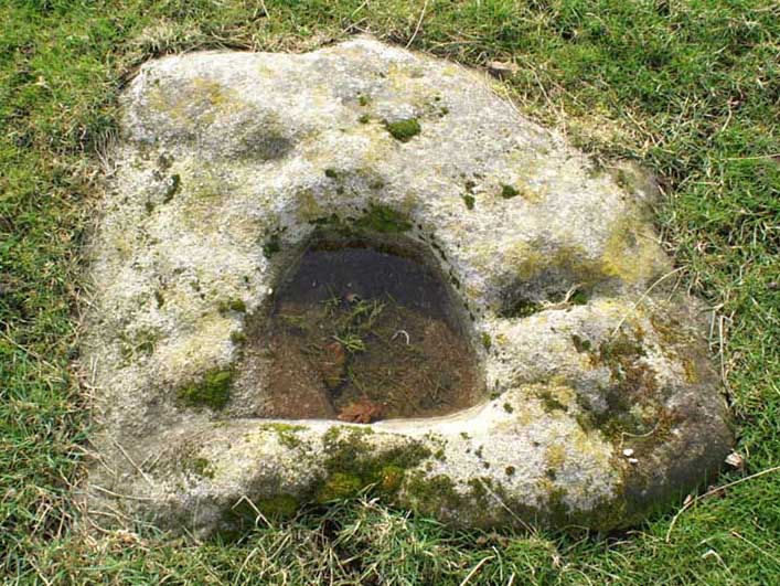
Described in Boughey & Vickerman’s (2003) survey as a “low, medium-sized, quadrant-shaped rock standing up from surroundings, with hollowed out central area.” This hollowed-out central area is, in all likelihood, the remains of a previously unrecognized old cross-base, although investigating archaeologists have somehow missed this. The stone’s proximity to the old Monk’s Way — a medieval trade route used by the local monastic Order — would give added weight to this assertion. A perusal of field-name records here may prove fruitful.
Our authors counted “eight possible small, badly worn cups, (with) three grooves running from central basin, all possibly natural.” The grooves may well be natural, but I’d say that one or two of the cups appear to be genuine. The large hollow in the middle of the stone may originally have been a cup-marking (or maybe even a cup-and-ring — but we’ll never know), before it became used as a site to erect a primitive cross.
Several other cup-and-ring carvings can be found around here — the Eastwoods Farm Cup is in the same field nearby— with the great likelihood of there being others hidden amidst trees or grasses, waiting to be re-awakened! The hugely impressive Morphing Stone and a prehistoric lightning-carving can be found in the next field, full of rocks, on the other side of the stream.
References:
Boughey, Keith & Vickerman, E.A., Prehistoric Rock Art of the West Riding, West Yorkshire Archaeology Service 2003.
From the large village of Summerbridge, go west along the B6541 towards Dacre Banks, where you’ll see the signpost for the Nidderdale Way footpath. Follow this past the disused quarry and onto the meadows. When you hit the Monk Ing road, bear right (north) and keep going till you’re 100 yards from Eastwoods Farm. Go right, down into the fields for 50 yards or so. Look around!
Archaeology & History
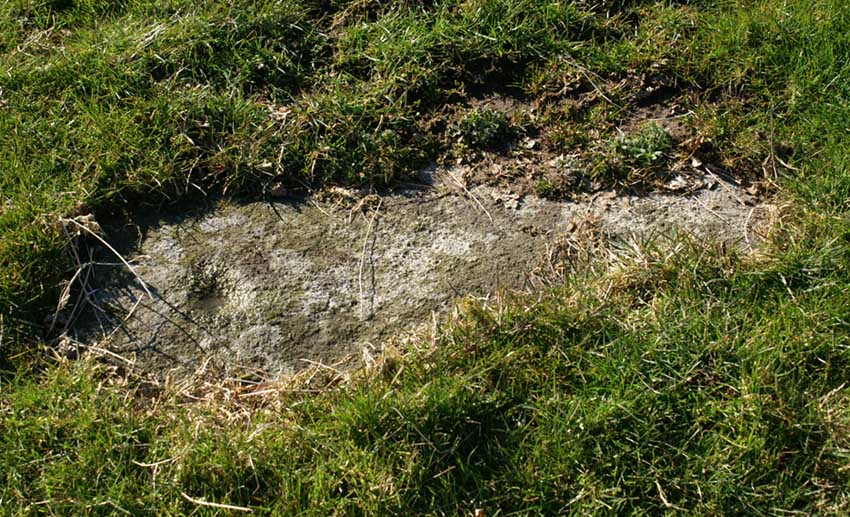
A previously unlisted single cup-marked stone which is likely to become overgrown by the grasses pretty soon. Several other carvings are in close attendance in this field. It’s not far from the cup-marked Eastwoods Cross Base (aka CR 637) in the same field, but a little further down. In all probability there are other carvings yet to be found in this area. The rock art student Keith Boughey (2007) mentioned it briefly in an article on the other carvings nearby, saying simply:
“A small area of rock (very possibly bedrock) measuring 40cm x 14cm at its greatest extent pokes up through the turf, showing one worn but clear cup-mark on its western edge (Fig 3). On its own, this marking would not be significant were it not for the fact that four other carved rocks are already recorded from this particular locality.”
From Carlton, take the western Hirst Road to Temple Hirst village, then turn right once you’re in the village and go up Common Lane up for about a mile. There’s a footpath on your left leading you to the Fair Oaks farmhouse. This was the spot!
Archaeology & History
This is fascinating sounding place which marked the central point of three old township boundaries nearly 1000 years ago. I first found it mentioned in Morrell’s History and Antiquities of Selby (1867: 36-7), where this once famous tree is described in land sale transactions. Morrell told:
“At Carlton the (Selby) abbey had considerable property, which was sold to the neighbouring priory of Drax. The boundary of the property sold was a certain oak tree, called Fair-haia, in Burn Wood, which Adam de Bellaqua gave for this purpose, binding himself and his heirs never to cut it down or root it up, sub poena anathematis.”
But we found a more detailed outline in Dugdale’s Selby Abbey in Yorkshire, where the premises and townships given to Selby Abbey in the 12th and 13th centuries are listed. In the township of ‘Carleton’ (as it was then spelt) Dugdale wrote:
“Peter de Brus gave the grange here, which the monks had held of Agnes, late wife of Ranulph FitzSwain. Richard abbat of Selby granted to Robert prior of Drax all the tithe from the north part of the oak called Fair-haia, in the wood of Birne, or Berlay, through the middle of the marsh to Hundolfsweith; and from thence by the strait ditch directly to Espholm, and all the tithe from Espholme to Appletreholme, as the ditch goes to the new fosse or ditch of Carleton: and the prior granted to the abbat all the tithes on the south to the new ditch, and from thence to the river Ayre. And Adam de Bellaqua gave this oak tree, called Fair-haia, as a boundary, never to be cut down (ad standum in perpetuum et non rescindendum), binding himself and his successors never to cut it down or root it up.”
One wonders: are there any remains left of this once great tree? Has anyone actually transgressed and uprooted it in times past? Is any other lore known of it? And who was Adam de Bellaqua?
One of the most intriguing elements to this site is its name, for the word ‘haia’ literally means ‘god of the land’ — but whether we can take this meaning seriously is questionable, as it’s of Sumerian origin. However, no local dialect words throw any light on the word and it may aswell be the name of the spirit of the tree as anything else. Does anyone know owt more about this place?
To get here, follow the same directions as if you’re going to the Morphing Stone. This carving is in the same field, but about 100 yards SSW of there, just to the south-side of the Nidderdale Way footpath. There’s plenty of rocks about, but with a bit of patience or a natural rock-art dowser’s nose, you’ll find the carving easily enough!
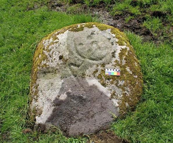
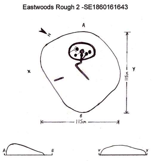
This is another relatively recent find — though I wonder whether the nearby ‘Fertility Stone’ (about 500 yards north, in some walling) should switch names with this carving, as this one gives the distinct impression of sperm fertilizing the egg! Don’t you agree!? The name of the Tadpole Stone was given to it by Michala Potts — and the photograph and design are used, courtesy of Richard Stroud. In the next field from here, towards Eastwoods Farm, we find the Eastwoods Cross base and cup-markings and adjacent cup-marked stone. Not far away are other carvings, aswell as a number of other Bronze- and Iron-Age sites.
This design was described in Keith Boughey’s (2007) article on the rock art around Eastwoods Farm, telling how it
“was discovered by Kevin Cale and reported to the N.Y.C.C. SMR back in 2001… A low profile moss-covered earthfast rock a little over 1m in diameter in any one direction immediately S of the Nidderdale Way about 100m east of the end of Monk Ing Road and S of Eastwoods Farm at SE 18601 61643 and 172m O.D. Its domed surface carries a somewhat unusual design interestingly reminiscent of the design carved at the previous site which lies in the same field and landscape 160m to the north-west… An oval or egg-shaped groove enclosed up to six cups; a groove or channel, often referred to as a ‘comet tail’ in rock art motif vocabulary, runs from the central group of the six out beyond the enclosing groove, bends sharply and continues down over the sloping face of the rock. A wide groove at the base of the rock running into the present turf line may be a further element of the carving.”
References:
Boughey, K., “Prehistoric Rock Art: Four New Discoveries in Nidderdale,” in Prehistoric Research Section Bulletin, no.44, Yorkshire Archaeological Society 2007.
Very little appears to have been written about this site, due no doubt to lack of archaeological investigation aswell as the destructive powers of intense agricultural practices hereby. It was first described in the Yorkshire Archaeological Register and told about by a Mr. H.G. Ramm, who told us of,
“a probable cursus in the Scales, Fimber Grange and Fimber Station area. An aerial photograph taken by John Dent has entended parallel ditches previously known in fragmentary form and enabling them to be interpreted as a cursus running along the valley floor, the north ditch from SE 8939 6106 to SE 9075 6104 and the southern ditch from SE 8937 6103 to SE 9068 6102. The distance between the ditches varies from 18-27m west of Fimber Grange to 30-37m east of the Grange. A trapezoidal enclosure, 30m by 15m, possibly a small long barrow, has been identified at SE 9008 6104, oblique to the north cursus ditch, which bends to take in account of it. A group of five ring ditches, three of which are in the cursus, lies to the west of Fimber Grange, but indicate a wartime searchlight post.”
This makes the length of this monument pretty short, but the faint remains of this possible cursus are visible on aerial shots. A number of other large ancient earthworks were charted here by the famous archaeologist, J.R. Mortimer (1905), though he made no mention of this particular site.
More info please!
References:
Edmondson, T., History of Fimber, H. Smithson: Malton 1857.
Gutch, Mrs. E., Examples of Printed Folk-lore Concerning the East Riding of Yorkshire, David Nutt: London 1912.