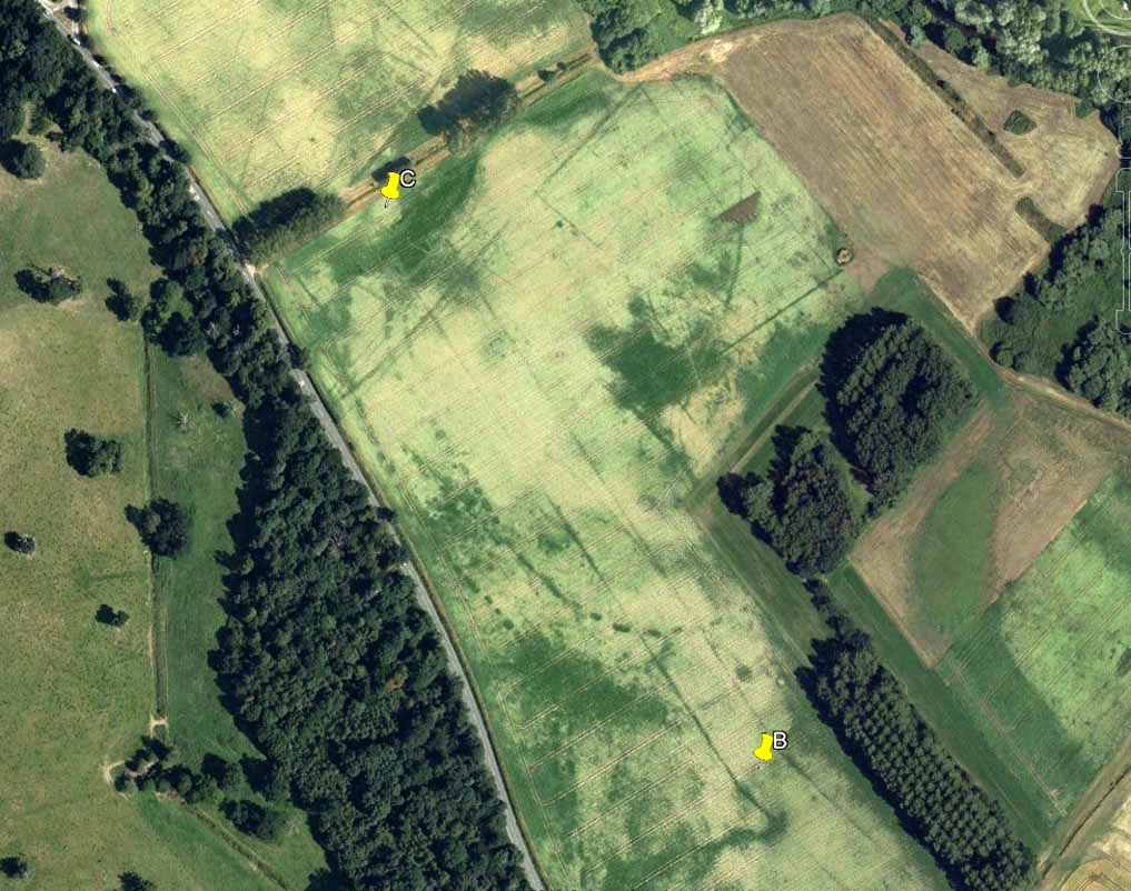
If you wanna find this, get onto the Low Plain north of the Dobrudden caravan park and its about 10 yards off the path running north from there, not too far from the other Baildon Hill carvings. Scramble about a bit & you’ll find it.
Archaeology & History
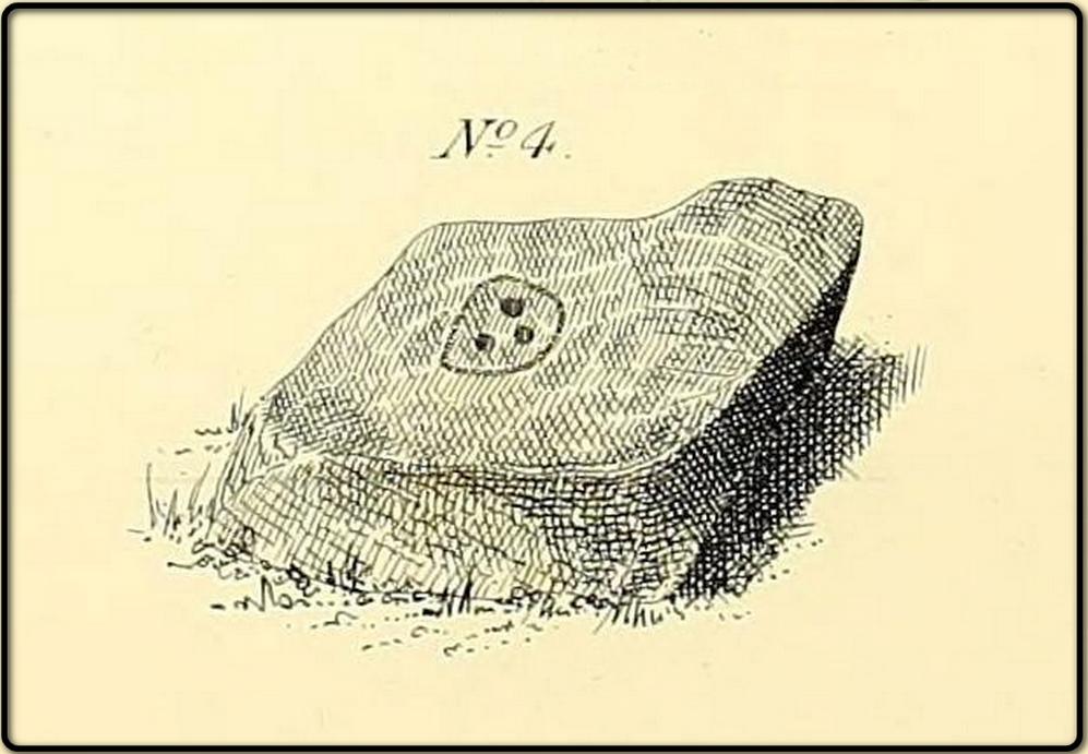
W.P. Baildon’s early sketch
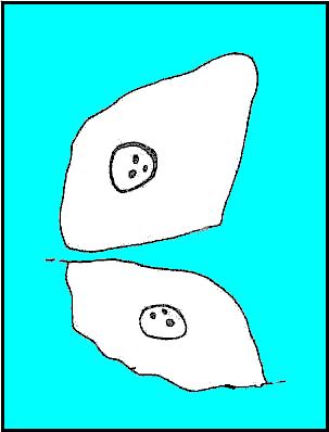
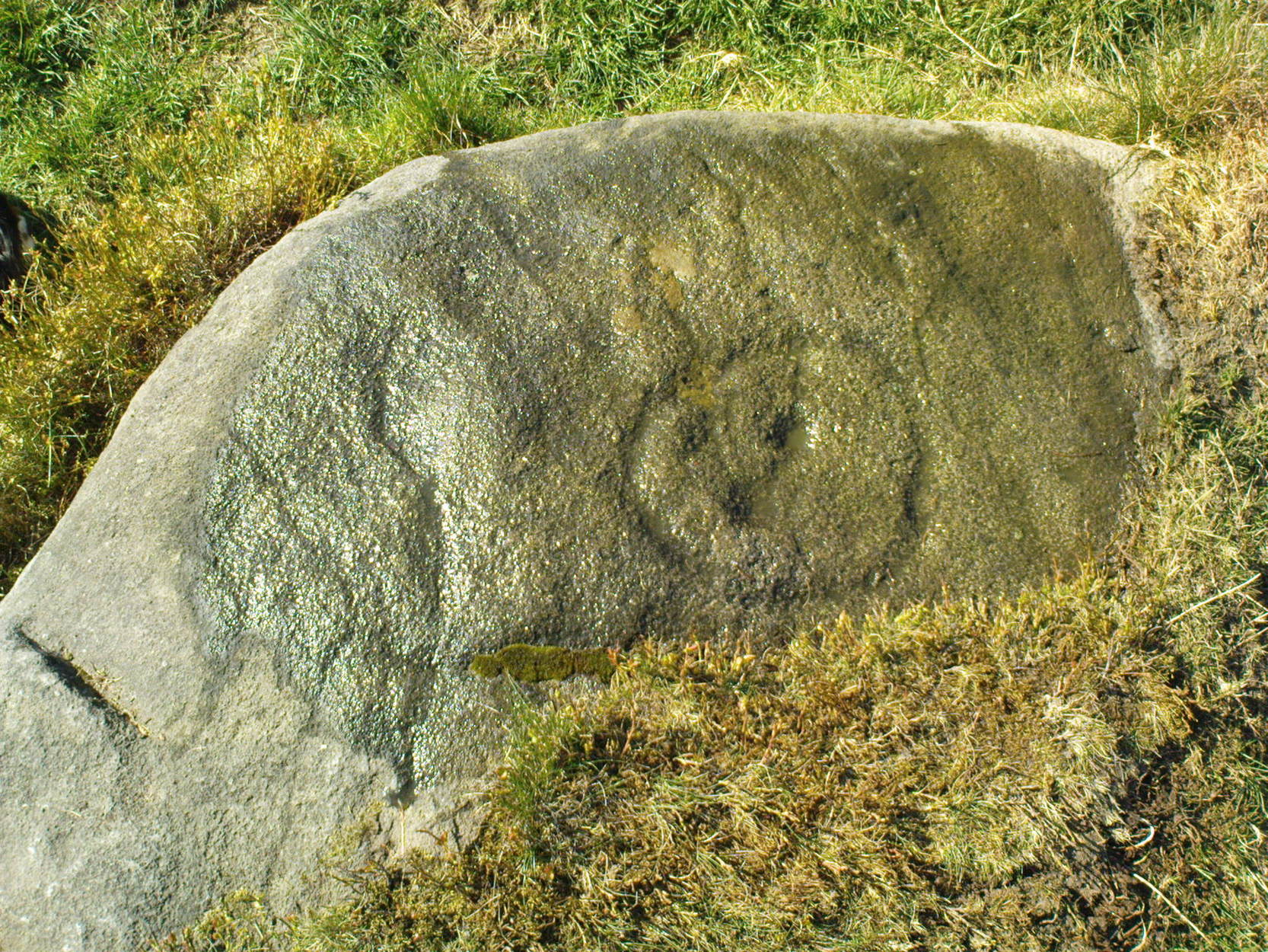
Don’t ask me why, but I really like this carving. It’s one of the many I first saw on these moors when wandering about up here when I was 10-12 years old — and they had an effect on me. I call this one of the “primary design” stones, i.e., a number of CRs on this moor (and everywhere else for that matter) appears to have a central design feature. (I’ll point out the others as I post ’em) Some folk think it’s just the slant of the local rock-artist…I think it’s summat a bit different… Local astronomer Gordon Holmes (1997) found a similar pattern here and thought they may have represented star formations, but this is unlikely.
It was first described and illustrated by W. Paley Baildon (1913), way before Mr Jackson (1955) resurrected its attention for archaeologists.
References:
Baildon, W. Paley, Baildon and the Baildons (parts 1-15), St. Catherines: Adelphi 1913-26.
Boughey, K.J.S. & Vickerman, E.A., Prehistoric Rock Art of the West Riding, WYAS: Leeds 2003.
Hedges, John (ed.), The Carved Rocks of Rombald’s Moor, WYMCC: Wakefield 1986.
Holmes, Gordon, 2000 BC – A Neolithic Solstice Odyssey, SASRG 1997.
Jackson, Sidney, ‘Cup-and-Ring Boulders of Baildon Moor,’ in Cartwright Hall Archaeology Group Bulletin, 1:7, 1955.
South of Dobrudden caravan park, heading towards the wall, you’ll stumble across this old carving in the tribbly grass. Zigzag about and keep your eyes peeled!
Archaeology & History
First described by W. Paley Baildon in his monumental 15-part study (1913) of the region, this carving was then later included in John Hedges (1986) survey as ‘Baildon stone 19.’ It was then catalogued as stone 146 in Boughey & Vickerman’s (2003) updated and expanded survey.
Modern drawing (after Hedges 1986)
This carving was one of several in the Baildon Moor complex that was thought by local astronomer Gordon Holmes (1997) to possibly represent heavenly constellations, with Pleiades and Cassiopeia being primary contenders amidst the scattering of carved cups on this stone. This was something I explored in my own research on the possible nature of these carvings in the 1980s, but found that although it seemed a good idea, it was pretty unlikely (unfortunately!). The nature of this and other stones related to the other prehistoric remains where, in bygone days, many prehistoric cairns scattered this grassy moorland plain. The carving was more related to the cosmology of death and the psychogeography of spirit worlds: a factor understood at many other cup-and-rings across the country.
References:
Baildon, W. Paley, Baildon and the Baildons – parts 1-15, Adelphi: London 1913-1926.
Boughey, Keith & Vickerman, E.A., Prehistoric Rock Art of the West Riding, WYAS: Leeds 2003.
Cowling, Eric T., Rombald’s Way, William Walker: Otley 1946.
Hedges, John, The Carved Rocks on Rombald’s Moor, WYMCC: Wakefield 1986.
Holmes, Gordon, 2000 BC – A Neolithic Odyssey, SASRG: Baildon 1997.
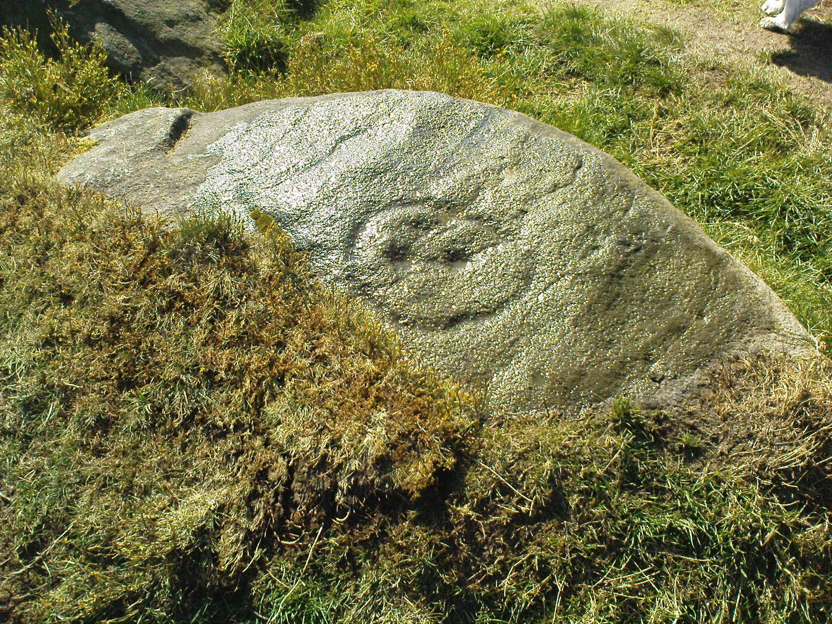
This lovely little stone is found on Shipley Glen. Walk a few hundred yards up past the Brackenhall circle until, on the right-hand side of the road, you reach the track which leads up the slope to Mitton Springs farmhouse. About 20 yards past the track, cross the road from and near to where the land drops down to the glen below and about 20 yards from the rowan tree, you’ll find this carving on one of the smaller low flat stones. Be patient and look around. You’re damn close!
Archaeology & History
The carving first appears to have been described by the Bradford historian, William Glossop (1888), in his local survey of prehistoric remains here (see his drawing). It’s a cute little thing on a small stone, consisting of a simple large ‘enclosure’ ring with three archetypal cup-markings etched inside. Described by several other local writers since, no other archaeological remains have been found in relation to this carving, making any realistic academic assessment on its nature almost wholly impossible.
(after Hedges, 1968)
References:
Baildon, W. Paley, Baildon and the Baildons (parts 1-15), St. Catherines: Adelphi 1913-26.
Boughey, K.J.S. & Vickerman, E.A., Prehistoric Rock Art of the West Riding, WYAS: Leeds 2003.
Glossop, William, “Ancient British Remains on Baildon Moor,” in Bradford Antiquary No.1, 1888.
Hedges, John (ed.), The Carved Rocks of Rombald’s Moor, WYMCC: Wakefield 1986.
Start at the Nick of Pendle and walk up the footpath towards the denuded Apronful of Stones’ cairn. Keep going up the hill for another 300 yards or so, just past where there’s a path that turns-off towards the ritual Deer Stones. As you walk upwards, in front of you you’ll see the tell-tale sign of many small stones scattered in their tell-tale manner, rising up at the edge of the footpath. This is it!
Archaeology & History
This was the third in a group of previously unrecognized giant cairns that I found in August 2006 (it certainly wasn’t in the archaeology records anyway), all on the south side of our legendary Pendle Hill — and it’s bloody huge! However, unlike the other two (the Devil’s Apronful and the Lower Apronful of Stones, further down the slopes), this one doesn’t seem as certain as the other two, but it’s still worth including here and cannot be discounted until a decent archaeological assessment has been made.
Looking up to the height of the Badger Wells Cairn
Section of the surface remains, showing thousands of stones
Just like its companion cairns, although it’s covered over with much soil and grasses, all round the edges are hundreds of small stones and rocks, of the same type and size as the other two a bit further down the hill, and similar to the Skirtful of Stones on Ilkley and elsewhere. The overgrown heap of stones here stands about ten-feet tall from the lower western edge and measures approximately 28 yards (north-south) by 20 yards (east-west).
Although this cairn is named after the nearby Badger Wells — which gets its name either from the local badger population, or else the old ‘badger-men’ who used to trade hereby — another fresh water source also emerges near the bottom of its western side.
Upon asking a couple of passers-by (they were local regular walkers up this great hill) about this and the other giant overgrown cairns upon this hill, they didn’t have a clue they existed — although they did suggest we contact the Lord of Downham on the north side of the hill. And so there we ventured, in search of the Great Stone – and guess who we bumped into…?
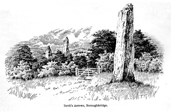
Dead easy to find! Turn off the A1(M) at the A6055 Boroughbridge road and head into town. Turn left after the Three Arrows Hotel, down Roecliffe Lane and the stones are a few hundred yards down, close to the motorway. The tallest is just off the road to the left, behind a gate (the owner of the adjacent house there is very pleasant), whilst the other two are across the road in the fields.
Archaeology & History
Devil’s Arrows (Percy Robinson, c.1895)
To many archaeo-megalithic and folklore fans, these huge standing stones need no introduction. These great heathen Arrows of the devil, today at least, are three gigantic standing stones, each one weighing several tons at least, standing in a rough straight line, nearly north-south. This is the greatest single stone-row anywhere in the British Isles.
Just how many standing stones originally stood here is difficult to say. We know from the records of early antiquarians and travellers that we had at least five Arrows here in centuries gone by; but one curious account, mentioned by the Yorkshire antiquarian Edmund Bogg (1895) more than a hundred years ago told:
“Peter Franck, a fisherman who travelled much about the world to enjoy his sport, came to Boroughbridge in 1694 and says he saw seven of these standing stones, Dr Stukeley mentions five, and John Leyland, in his travels, saw ‘four great stones wrought by man’s hands,’ but no inscription upon them. Camden, in 1592, saw four, but one of them at the time was thrown down, ‘for,’ says he, ‘the accursed love of gain.’ Part of this one is still to be seen, built into the Peggy Bridge which crosses the Tut on the entrance to the town, the top portion being preserved in the grounds of Aldborough Manor and this goes far to prove — and I have very carefully considered the question and examined the ground — that the original number of stones was far greater, and reached from the Yore, in equal distances to the Tudland of Leyland’s time, or the Staveley Beck of today. If this argument is correct, 2000 years ago there would be a line of at least 12 standing monoliths guarding the western approach to Isur Brigantium.”
John Aubrey’s 1687 plan Devil Arrows Stone Circle
Will Stukeley’s 1776 image
Well y’ never know! But who was this Peter Franck chap from the 17th century? It would be good to find out more of what he said.
But this notion of there being a great many more stones here than the four or five that are accepted as standard, isn’t just to be found in the annals of some lost fisherman. The great Royalist antiquarian John Aubrey came here in September 1687 and, as illustrated here, saw the remaining three upright stones as remnants of a concentric ring of stones of obviously gigantic proportions. Following from a rough survey of the site and descriptions from local people, Aubrey placed the standing stones in their old line, of
“A. B. C. D., and I have drawn two imaginary circles in which it may be supposed that stones were placed, as at Avebury, Stonehenge, etc. Perhaps they might be more stones in each circle than I have fancied.”
Nearly two hundred years later, archaeologist John Ackerman (1847) echoed John Aubrey’s notion (or perhaps simply copied them) in his notion of the Devil’s Arrows once being part of a greater megalithic complex, saying,
“At Rudston and Boroughbridge, in Yorkshire, are supposed examples of maenhirs. Near the latter place there are four standing in a row, which are called by the country people the Devil’s Bolts; but, from their relative position, it is not unlikely that they are the remains of a large circle.”
Devil’s Arrows (from Smith’s ‘Reliquiae’)
The top 2 Arrows
As if to tempt further enquiry, or at least require suitable explanation, is the nearby field-name of ‘Kringelker,’ or Cringles Carr — last described in 1316 — and which means very simply a circle by the marsh, or circular marsh, or variants thereof. (Source: Yorkshire Deeds, volume 4,YAS: Leeds 1904)
But prior to John Aubrey’s speculations on the Arrows being part of a giant ring of stones, he related the earliest survey done here, by a local (unnamed) man on April 17, 1669, telling that:
John Aubrey’s 1687 sketch of the Arrows
“In Yorkshire near Burrough-brig on the west side of the Fosse-way, about a quarter of a mile, (in the Lordship of Alburgh) stand three pyramidish stones called the Devills Arrowes. The Arrow standing towards the south is seven yards and a half in height: the compasse of it five yards and a half. The middle Arrow seven yards and a half, in compass six yards. The Arrow towards the north in height five yards and a half, in compass seven yards. Here was another stone that stood in a straight line, at D, that was taken down and a bridge made of it.”
Other regal antiquarians and learned writers of the period came soon after. When William Camden (1695) visited the place at the end of the 16th century, he was equally impressed and described the place as follows:
“Not farre beneath there standeth by Ure a little towne called Burrowbridge, of the bridge that is made over the river: which is now built very high and faire of stone worke, but in King Edward the Second his time it seemeth to have beene of wood. For wee read that when the Nobles of England disquieted this king and troubled the state, Humfrey Bohun Earle of Hereford in his going over it was at a chinke thereof thrust through the body about his groine by a souldiour lying close under the bridge. Neere unto this bridge Westward wee saw in three divers little fields foure huge stones of pyramidall forme, but very rudely wrought, set as it were in a streight and direct line. The two Pyramides in the middest, whereof the one was lately pulled downe by some that hoped, though in vaine, to finde treasure, did almost touch one another. The uttermore stand not far off, yet almost in equall distance from these on both sides. Of these I have nothing else to say but that I am of opinion with some that they were monuments of victorie erected by the Romans hard by the high street that went this way. For I willingly overpasse the fables of the common people, who call them the Devills Bolts, which they shot at ancient cities and therewith overthrew them. Yet will not I passe over this, that very many, and those learned men, thinke they are not made of naturall stone in deed, but compounded of pure sand, lime, vitriol (whereof also they say there bee certaine small graines within), and some unctuous matter. Of such a kinde there were Rome cisterns, so firmely compact of very strong lime and sand, as Pliny writeth, that they seemed to be naturall stones.”
Another early antiquary, John Leland, also passed by here a few hundred years back and wrote the following after his visit:
“A little without this Towne on the west part of Watiling-Streate stadith 4 great maine stones wrought above in conum by Mannes hand. They be set in 3 several Feldes at this Tyme. The first is a 20 foote by estimation in higeth and an 18 foote in cumpace. The stone towards the ground is sumwhat square, and so up to the midle, and then wrought with certen rude boltells in conum. But the very toppe thereof is broken of a 3 or 4 footes. Other 2 of like shap stand in another feld a good But shot of: and the one of them is bigger then the other; and they stand within a 6 or 8 fote one of the other. The fourth standith in a several feld a good stone cast from the other, and is bigger and higher than any of the other 3. I esteme it to the waite of a 5 Waine Lodes or more.
Inscription could I none find yn these stones; and if there were it might be woren out; for they be sore woren and scalid with wether.
I take to be a trophaea a Romanis posita in the side of Watheling Streat, as yn a place most occupied in Yorneying ad so most yn sighte.”
Possible cup-marks on northernmost Arrow
Rock Art on the Devil’s Arrows
Although Leland told us he could find no inscriptions on the stones, he missed some which may be much older than the purely Roman marks his nose was seeking. Cup-and-ring stones — much in vogue nowadays thanks to the new, shamanically-inspired archaeo’s — aren’t etched here in anything like the styles expected of our Swastika Stone, or the Achnabreck carvings, but cup-markings seem to occur on the northernmost stone. Although a rather myopic bunch of earth-mystery people thought they were the first to discovered the cup-markings here in 2005, they were in fact first described way back in 1866, in Sir James Simpson’s precursory essay to his Archaic Sculpturings (1867), where he told:
“In England the most striking and magnificent group of monoliths that I have seen are the so called Devil’s Arrows at Borough-Bridge, in Yorkshire. Three only of these tall and enormous monoliths are now left, and stand in a line about a stone’s throw from each other. They are all pillars of a squarish shape, and said to bo formed of millstone grit. Two of them are above twenty-two feet in height, and the third measures eighteen feet. Each at its upper part is deeply and vertically guttered, apparently by long weathering and exposure ; and their lower portions show round, smooth, cup-like excavations upon some of their surfaces. The most northerly of these imposing monoliths is especially marked in this last way. Many, if not all, of these excavations, have probably been effected by the elements and weather; while some of them, which look more artificial, are of the same shape and form as those on the Kilmartin stones, etc. But unfortunately we have not here the presence of rings or circles around the cups to determine conclusively their artificial character.”
The central Arrow
Some of the cup-markings here are distinctly artificial; but as with these ancient non-linear designs in general, we are unable to ascertain any specific ‘meaning’ to them at this site, even in any mythic sense — as yet! (I’ll get some images of cup-markings next time I visit the Arrows, unless someone has some going spare!)
Folklore
Described by Bob Mortimer (1860) as a gathering place of the druids, who “met here to celebrate their great quarternal sacrifice”; not unsurprisingly there are a variety of other fascinating creation myths and folklore motifs raising their usual heads by these great stones. Mortimer told of more tales following his local society’s visit here at the end of the 1850s, saying:
“There lived a very pious old man (a Druid should we imagine) who was reckoned an excellent cultivator of the soil. However, during each season at the time his crops had come to maturity they were woefully pillaged by his surrounding neighbours; so that at this, he being provokingly grieved, the Devil appeared, telling the old man if he would only recant and throw away his holiness he should never more be disturbed in his mind, or have whatever he grew stolen or demolished. The old man, like Eve in the garden, yielded to temptation, and at once obeyed the impulse of Satan for the benefit of worldly gain. So when the old man’s crops were again being pillaged, the Devil threw from the infernal regions some ponderous arrows, which so frightened the plunderers by shaking the earth that never more was he harrassed in that way. Hence the name of the ‘Devil’s Arrows.'”
Another individual told me that it was believed by some that the stones sprung up one night in the very places they now occupy.”
Very close to the Arrows are antiquarian records of other sites which someone can hopefully throw more light on, as they may have had some relationship with the stones. Immediately west were (are?) the Penny Stones; plus a place called Bell’s Wife’s Field (Bel as a sun-god – though his wife may imply the moon). And just a few hundred yards east is the old Lady Well, mentioned elsewhere.
…to be continued…
References:
Ackerman, John Yonge, An Archaeological Index to the Remains of Antiquity of the Celtic, Romano-British and Anglo-Saxon Periods, J.R. Smith: London 1847.
The Stranger’s Guide; Being a Concise History & Description of Boroughbridge, John Mitchell: Boroughbridge 1846.
Bennett, Paul, The Devils Arrows, Heathen Earth: Keighley 2009.
Bogg, Edmund, From Eden Vale to the Plains of York, Goodall & Suddick: Leeds n.d. (c.1895)
Bogg, E., Richmondshire and the Vale of Mowbray (volume 1), Elliott Stock: London 1906.
Brayshaw,Thomas, ‘The Yorkshire Portions of Leland’s Itinerary,’ in YAJ 10, 1889.
Burl, Aubrey, ‘The Devil’s Arrows,’ in YAJ 63, 1991.
Burl, Aubrey, From Carnac to Callanish, Yale: New Haven & London 1993.
Camden, William, Britannia, or a Chorographical Description of Great Britain and Ireland, Edmund Gibson: London 1695.
Devereux, Paul & Thomson, Ian, The Ley Hunter’s Companion, Thames & Hudson: London 1979.
Elgee, F. & H.W., The Archaeology of Yorkshire, Methuen: London 1933.
Forrest, Bob & Behrend, Michael, ‘The Devil’s Arrows on Target,’ in The Ley Hunter,no.107, 1989.
Lawson-Tancred, Lady, A Guide Book to the Antiquities of Aldborough and Boroughbridge, J. Topham: Boroughbridge 1948.
Leadman, A.D.H., ‘The Devil’s Arrows,’ in The Antiquary, 1903.
Leland, J.J., The Itinerary of John Leland the Antiquary, Fletcher & Pote: Oxford 1770.
Lewis, A.L., ‘The Devil’s Arrows, Yorkshire,’ in Journal. Anthr. Institute, 8, 1878.
Longworth, Ian H., Regional Archaeologies: Yorkshire, Cory, Adams & Mackay: London 1965.
Lukis, W.C., ‘The Devil’s Arrows,’ in Proc. Soc. Antiquaries London, volume 7, 1877.
Lukis, W.C. (ed.), The Family Memoirs of the Rev. William Stukeley – volume 3, Surtees Society: Durham 1887.
Mee, Arthur, Yorkshire, West Riding, Hodder & Stoughton: London 1941.
Mortimer, Robert, ‘The Great Monoliths at Boroughbridge,’ in The Geologist journal, London 1860.
Phillips, Guy Ragland, Brigantia, RKP: London 1976.
Radley, J., ‘Prehistory of the Vale of York,’ in YAJ 1974.
Ross, Frederick, Legendary Yorkshire, William Andrews: Hull 1892.
Simpson, James Y., Archaic Sculpturings of Cups, Circles, etc., upon Stones and Rocks in Scotland, England and Other Countries, Edmonston and Douglas: Oxford 1867.
Smith, A.H., Place-Names of the West Riding of Yorkshire (volume 5), EPNS: Cambridge 1963.
Smith, Henry E., Reliquiae Isurianae, J.R. Smith: London 1852.
Somerville, Boyle, The Devil’s Arrows: Prehistoric Stone Monuments and their Orientation, B.A. Handbook, 1927.
Stukeley, William, Itinerarium Curiosum (volume 2), London 1776.
Thom, A.S. & Burl, Aubrey, Stone Rows and Standing Stones, BAR: Oxford 1990.
Turner, T.S., History of Aldborough and Boroughbridge, Arthur Hall: London 1853.
Tutin, John, ‘Theory about the Three Arrows,’ Yorkshire Life 3, 1954.
Walford, John. ‘An early description of the Devil’s Arrows, Boroughbridge, North Yorkshire,’ in Yorkshire Archaeological Journal, 79, 2007.
Wood, E.S., ‘The Grooves on the Devil’s Arrows, Boroughbridge,’ PPS 13, 1947.
From Askwith village, at the T-junction, go up Moor Lane, taking the left turn up Moorside Lane about half-a-mile up and on the track to Moorside Farm and then onto Top Moorside Farm. Take the path past the farm up onto the moor, then bear right up the small track that heads up onto the small Hollin Tree Hill. As you go up the track, watch out for the small grassy depression to the right; and hereby head into the grasses on your right. You’re close!
Graeme Chappell was the first to rediscover this carving in the early 1990s when we were up pottering about on these and the adjacent moors, looking for any previously undiscovered prehistoric relics. We found quite a lot! The carving here is nowt special to look at really, but the cups can be seen quite clearly. It’s a rather large stone on the western edge of the hill with at least seven or eight cup-marks carved across its upper surface. Boughey & Vickerman (2003) later described it as “large, fine quartz sandstone rock with surface sloping slightly down into (the) hillside. Seven or eight cups, two particularly sharp.” There’s a possible line running between two of the cups, visible when lighting conditions are right — though we aint sure whether it’s artificial or not.
References:
Boughey, Keith & Vickerman, E.A., Prehistoric Rock Art of the West Riding, WYAS 2003.
Paul, Danny and I came here via the Feizor village route, zigzagging about, to and fro, seeing the other old sites in the region; but the easier direct way to get here would be from Settle. Walking through Settle, going out of the top end of town, cross the old bridge and take the country-lane on the right, up northwards towards Stackhouse. A mile along the road (shortly before Stackhouse), a footpath on your left veers up diagonally through a small copse of woods. Go up here and out the other side of the trees, the path turns left and up over the fields. Go up here, and over the third wall along the footpath, you’ll see a large overgrown pile of rocks 30 yards in front of you with a large stone laid roughly in its middle. You’re here!
Archaeology & History
This is an excellent though much neglected prehistoric cairn of some considerable proportions, its rocky mass laying half-covered in deep earth and grasses, yet with still a very large section of it open to the elements. The creature is nearly 30 yards across and some 4 yards high — though it’s hard to say with any certainty, where exactly the natural Earth begins and the cairn starts. But from whichever way you look at this large cairn, walking around the overgrown features, you know it’s a big thing — similar in size and nature to the Great Skirtful of Stones on Burley Moor, and the neolithic cairn on Bradley Moor, near Skipton.
Paul & Danny atop o’ t’ pile
Bear’s photo, looking SW
On the modern OS-map there are 2 ancient cairns marked close to each other — and our “Apronful of Stones” is the lower one of the two.
In recent years the site was described briefly in Dixon’s (1991) Journey through Brigantia, but there’s been very little written about the place in modern archaeological surveys. The first account I’ve found of the site was written by an anonymous “W.F.” in The Gentleman’s Magazine of 1784. In a detailed lengthy essay, the following words were penned:
“This barrow, or tumulus, stands in an elevated situation, upon a mountain, above the hamlet of Stackhouse, and may be discerned at a great distance…
“The form of this vast mass is circular, or rather orbicular ; the height, by computation on the spot, about 9 or 10 feet. It is composed of an incredible quantity of stones, piled in such a manner as to rest upon each other’s basis, and strengthened by its conic form, it rises upwards in this curious shape. Those stones that form the outside of the work are so small that a soldier could carry them; and since it has been argued that such a monstrous work as this would not be attempted by any nation, but was natural, the largeness of the tumulus may easily be accounted for, since they were annually increased out of reverence…
“This barrow had been opened many years ago, and it is represented in the plate in the state in which it has appeared till lately. Some old people in the neighbourhood remember its being entirely complete, and having a very flat top. It was usual, in finishing these works, to lay a flat stone at the top. The people that opened it left their intention unfinished, only throwing down the lid of the stone coffer, and one or two of the sides; and, meeting with nothing worth digging for, they left it. Upon examining it in this state, before its being entirely disfigured in the last attempt, I found several human bones scattered up and down therein, amongst which I selected the patelae of the knee, the vertebrae of the spine, part of the jaw, and several teeth.
“Round the area is a wall or rampart, of the same materials as the outside, its height from the interior part about 2 feet, irregularly ranged with fissured remnants. In the centre of the cavity or area is the above chest, consisting of several huge stones of vast magnitude and density, fixed firmly into the ground, which supported a lid of equal size, though it is now thrown off the top. In this chest are partitions, for what purpose is not known, unless each space was allotted to its particular relique or body. In the partitions and sides of the coffin is a kind of hole in the edge, with a rude mould. (my italics, PB) Not many weeks ago, the curiosity of some of the neighbourhood was excited to investigate this stupendous work of art, and accordingly labourers were hired, when, upon searching a day (yet not half the work done), a human skeleton was found, in due proportion, and in a fine state of preservation, excepting the skull and one of the limbs, which were moved out of their place by the workmen’s tools. A small circular piece of ivory, and the tusk of an unknown beast, supposed to be of the hog genus, was also found ; but no ashes, urns, coins, or instruments were discovered. ”
Many years later the giant cairn was described briefly in William Howson’s (1850) early survey of the district, when he told that,
“Near a gate on the path, where the descent is commenced to Stackhouse, there’s a cairn of eighty feet in diameter; it has not been completely examined, but human bones are commonly found in it.”
But it was more than a century after “W.F.’s” initial essay before another detailed appraisal of the place was given — and that was after a visit here by the legendary Harry Speight (1892) in the latter half of the 19th century. Along with mentioning a number of other prehistoric tombs upon this ridge, Mr Speight told:
“From Settle Bridge you may take the field-path…or the rustic lane to Stackhouse, and where the road divides just beyond Mr Priestley’s pretty house you wind beneath the wood behind Scale House to a gate and stile on the left. Here ascend the field between two large trees, and at the top go over a stile, whence a path leads up the field a good half-mile to a gate which opens into what our remote Celtic ancestors would have reverentially called the ‘Field of the Dead,’ for within this enclosure are traces and remains of human graves which carry us back to the far dim ages of unwritten history. Following the grassy cart-road a short distance you will see on the left a large circular mound thrown up about 30 feet on the south side, and about 10 feet on the north or higher side. There are other mounds of similar and smaller dimensions within the same area, some of which have been examined, but others do not appear to have been disturbed. Many of the barrows or ‘raises’, have at some time or other been carelessly dug into in the hope of finding valuables, and as doubtless in most cases nothing was found but rude chests or coffins, containing bones, these were tossed aside and no record of them deemed worthy of preservation…
“The largest of these existing raises has happily been described by a writer who signs himself ‘W.F.’ in the ‘Gentleman’s Magazine’ for 1784 and 1785. Although his account fills several pages, it is obviously defective in many particulars. We are told that the circumference of the base of the mound is 210 feet, and that its height is 9 or 10 yards, and that the casing is composed of stones “so small that a soldier could carry them,” while the inside is made up of earth and stones, some of the latter being “much larger than the external coating.” In form it was circular…and the diameter of the summit was 45 feet. The barrow he tells us was opened many years ago, but some old people in the neighbourhood remember it being entirely complete, and having a very flat top.
“…Upon examining it in its former state the writer discovered several human bones scattered about the rock and soil, among them the palletae of the knee, the vertebrae of the spine, part of the jaw and several teeth. In the centre of the mound was a cavity containing a chest composed of four upright stones and a lid 6 feet 9 inches long and 3 feet broad. The chest was in partitions, in the edges of which were a kind of hole with a rude mould. The writer, under date, Settle, Nov 23rd 1784, next informs us that, “not many weeks ago the curiosity of some of the neighbourhood was excited to investigate this stupendous work of art, and accordingly labourers were hired, when upon searching a day (yet not half the work done) a human skeleton was found, in due proportion, and in a fine state of preservation, excepting the skull and one of the limbs, which were moved out of their place by the workmen’s tools. A small circular piece of ivory, and the tusk of an unknown beast, supposed to be of the hog genus, were also found; but no ashes, urns, coins, or instruments were discovered.”
Other important prehistoric monuments can be found on the grassy limestone plain beyond the Apronful: these include the fascinating Sheep Scar Enclosure just 180 yards (165m) to the north; an associated prehistoric cairn (one of several) 57 yards further northeast; and a delightful, though overgrown cairn circle 325 yards NNW. Other Iron Age and Bronze Age remains can be found elsewhere within this arena. Archaeologists could do themselves a big favour by exploring this landscape more efficiently than they’ve done so far as other unrecognized sites exist in this area.
Folklore
Big stone in t’ middle
Harry Speight (1892) told us how the place got its name “from a tradition…that his Satanic Majesty, in haste to complete the bridge bearing his evil name near Kirkby Lonsdale, tripped and his apron-string broke which let drop this immense heap.”
Another tradition narrated again by our anonymous ‘W.F.’ in the Gentleman’s Magazine(1785) said how this giant tomb, “was raised over the body of some of the Danes slain in the general massacre of that nation.” He also told, “Such a conspicuous work must certainly be erected to the manes of some chiefs, though there is no ground to support its tradition.”
References:
Dixon, John & Phillip, Journeys through Brigantia – volume 4: Beyond the Hill of Winds – Walks in Upper Ribblesdale, the Three Peaks & Upper Wharfedale, Aussteiger: Barnoldswick 1991.
Ferrand, William, “Stackhouse, Yorkshire,” in The Gentleman’s Magazine (London 1784).
Howson, William, An Illustrated Guide to the Curiosities of Craven, Wildman: Settle 1850.
Speight, Harry, The Craven and Northwest Yorkshire Highlands, Elliott Stock: London 1892.
Many ways to get here, but the easiest for those with cars to is park up on the southeast edge of the hill, at the various scruffy parking bits beside the road at the Nick of Pendle. The view from here is enough to get you going! Walk onto the great hill up to the rounded pap of Apronfull Hill (rather gives it away really!). It’s only a few hundred yards up – about 10 mins up the slope from the road, with awesome views all round once you get there. Tis the small guidance cairn you’re looking at just on the level. You’re there!
Archaeology & History
This would once have been a rather huge cairn/tomb — though when I first found the remains of this place in August 2006, there were no archaeological records describing it that I could find. But there’s very little left of it. The lads who did the quarrying further downhill (where you’ve probably parked your car) are likely to have been the culprits who nicked most of the rocks that once made this huge forgotten tomb. But as you potter about here, it becomes obvious that you’re standing on the much-denuded remains of just such a monument (very similar in size and structure to the more famous Little Skirtful and Great Skirtful of Stones on Burley Moor, or Black Hill round cairn near Skipton). But the remains you can see beneath your feet still give a good idea as to how large it was.
Remnants of the cairn-spoil cover the ground where the monument once stood proud!
You’ll see once you’re stood here that there are hundreds, maybe even several thousands of stones just on and below the ground, scattering a very well-defined roughly circular area measuring at least 21 yards (east-west) by 22 yards (north-south), right by the side of the path. The edges of this ransacked cairn are pretty well defined around the north and eastern sides. Near the centre of the old structure is a very notable ‘dip’ in the ground where it looks as if something has been dug away — though this could just as well be due to the presence of underground water, as indicated by the growth of Juncus grasses. Without an excavation it’s obviously difficult to tell.
Folklore
Twas the following tale which first led my nose to explore this part of Pendle hill. It’s a tale we find at many of our upland tombs, though the record books said there was nowt here! (any myopic archaeologists out there who reckon that folklore has no relevance to their subject, educate one’s self!)
Looking from the Devil’s Apronful towards Jeppe Knave’s Grave
The Devil was having trouble with the folk at Clitheroe Castle (a few miles west) and wanted rid of it. So he picked up various large stones and put them in his apron then threw them towards the castle. Most of them missed, which made him angry and in a rage he accidentally dropped a great pile of rocks on the south side of Pendle Hill, creating the Devil’s Apronful on Apronfull Hill.
In another tale he was said to have stood at the Deer Stones a few hundred yards east of here and threw rocks from there. Perhaps a folk-remnant of where the Apronful stones once came from…? Perhaps not.
Jessica Lofthouse (1976) notes how this old spot was long known by local people as the Devil’s Apronful.
References:
Lofthouse, Jessica, North-Country Folklore, Hale: London 1976.
The Forham All Saints Cursus (image courtesy, Paul Devereux)
Archaeology & History
The remains of this cursus can be found in the valley of the Lark. In Paul Devereux’s (1989) survey of these gigantic neolithic features he described how today we can only see it as crop-markings, stretching in a
“roughly northwest to southeast direction for about a mile; its width approximately 140 feet (42.5 metres). It is comprised of three straight lengths, each at slightly different orientations – there is no way of telling at present (c.1988) whether or not these segments were built at different times, as is believed to be the case at certain other cursuses where changes of direction occur. The northmost terminus has not been located, but the southern one is visible from the air and is next to a circular crop-mark.”
Some 350 yards further on from the end of the cursus is the village church of All Saints, whose old festival date centred around Halloween, or the old pre-christian New Year.
Central section of cursus
Starting at the southern end of the cursus (A), it headed northwest for more than 650 yards (0.6km) before it took its first slight change of direction. Almost all of this first section has been built over by the village; but we can see it in aerial views again on the north side of the village at the edge of the field, at TL 8365 6774 (B). Changing direction slightly, it moves more NNW for another 590 yards (539m) and then kinks again slightly more NNW at TL 8325 6809 (C), before heading onto its final change in direction 464 yards (424m) away at TL 8299 6843 (D). From this point, more recent surveys have shown it to continue further onwards, with another minor alteration in its direction to the north. It goes in a dead straight line for another 336 yards (334.5m), seemingly terminating a short distance before the old Mill Farm at Hengrave, at TL 8291 6876. Just as at the start of the cursus at point ‘A’, where the terminus is curved in a slight arc, so the northern terminus was also curved. The total length of this monument is 1.2 miles (1.9km).
As can be seen in the aerial view (above), a faded double-line of earthworks exists immediately west (left) of the cursus, intersecting and going across the monument. This is the Fornham All Saints causewayed enclosure: another early neolithic monument which may or may not be earlier than the cursus itself.
A curious architectural coincidence (?) can be seen roughly 500 yards west of the central section of the cursus. Running roughly parallel with the prehistoric earthwork is another dead straight avenue leading out, southeast, from Hengrave Hall and, near its terminus, kinks slightly left, just as the cursus monument does about 550 yards away. Fascinating…
References:
Loveday, Roy, Inscribed Across the Landscape, Tempus: Stroud 2006.
Oswald, A., Dyer, C. & Barber, M., The Creation of Monuments, English Heritage: Swindon 2001.
Pennick, N. & Devereux, P., Lines on the Landscape, Robert Hale: London 1989.
Not hard to find really. From Ballachulish, take the western coastal road south, as if you’re going to Oban. After about 5 miles you’ll hit the lovely hamlet of Duror (nowt much here: a hotel, small school and a few cottages). Stop here and walk across the River Duror. A couple of fields down on your left-hand side you’ll see what you’re looking for!
Archaeology & History
Described as “one of the most impressive standing stones in Lorn,” northern Argyll, it “is situated in a level field 180m NW of Acharra. It measures 3.7m in height and 1.1m by 0.6 m at the base, and tapers to a pointed top about 0.4m in thickness; the long axis lies NE and SW.”
Aubrey Burl (Thom, Thom & Burl 1990) thought: “it is possible that this, and other stones near Loch Creran, once marked a prehistoric trackway, 4.5 miles in length.”
Folklore
On the potential folklore side of this monolith, Burl mentions how this monolith – also known as the Hard Stone – “and the site on which it stands, is called Cnoc nam Aingeal, or ‘Angel’s Hillock.'” Does anyone know the story behind this?
References:
Royal Commission on the Ancient & Historical Monuments of Scotland, Argyll: volume 2 – Lorn, HMSO: Edinburgh 1974.
Thom, A., Thom, A.S. & Burl, A., Stone Rows and Standing Stones, BAR: Oxford 1990.


")
")


sm")