Standing Stone (destroyed): OS Grid Reference – SP 257 282
Archaeology & History
We have found only one reference to this lost standing stone that could once be seen adjacent to the very well-preserved Chastleton Barrow Camp to the east of the village. In her scarce little work on the history of Chastleton House, Margaret Dickins (1900) told that,
“the oldest thing to be seen at Chastleton is the prehistoric stone, which till lately served as a field gate post on the Barrow Hill.”
This monolith was one in a series of megalithic sites in and around the village that have been destroyed due to the actions of ill-informed land-owners. In this case, the standing stone was in close association with the subsequent Iron Age encampment (this missing stone should not be confused with the nearby Goose Stones, greatly damaged).
References:
Bennett, P. & Chanter, James, The Complete Rollright Stones, forthcoming
Long Barrow (destroyed): OS Grid Reference – TL 086 268
Archaeology & History
Aligned east-west, a large neolithic long barrow could once be seen to the west of Galley Hill, on where now we find a golf course. It was sadly destroyed sometime around 1900 AD and its demolition was witnessed by a Mr A. Cumberland of the Dartford Antiquarian Society, who reported there being no archaeological finds of note in the tomb. Curious…
Equally curious was the view of archaeologist James Dyer (1964) in his assessment of the site, who wrote how
“Air photographs suggest that the barrow was 300 ft long, but this is much larger than normal in the Chilterns, and 150 ft is more reasonable.”
The neolithic and Bronze Age burial specialist Paul Ashbee (1984) maintained the “300 feet” measurement.
Other tumuli can still be seen on the slopes either side of Galley Hill a few hundred yards to the east; and a henge monument has also be found in the area.
References:
Ashbee, Paul, The Earthen Long Barrow in Britain, Geo: Norwich 1984.
Dyer, J.F., “A Secondary Neolithic Camp at Waulud’s Bank, Leagrave,” in Bedfordshire Archaeological Journal 2, 1964.
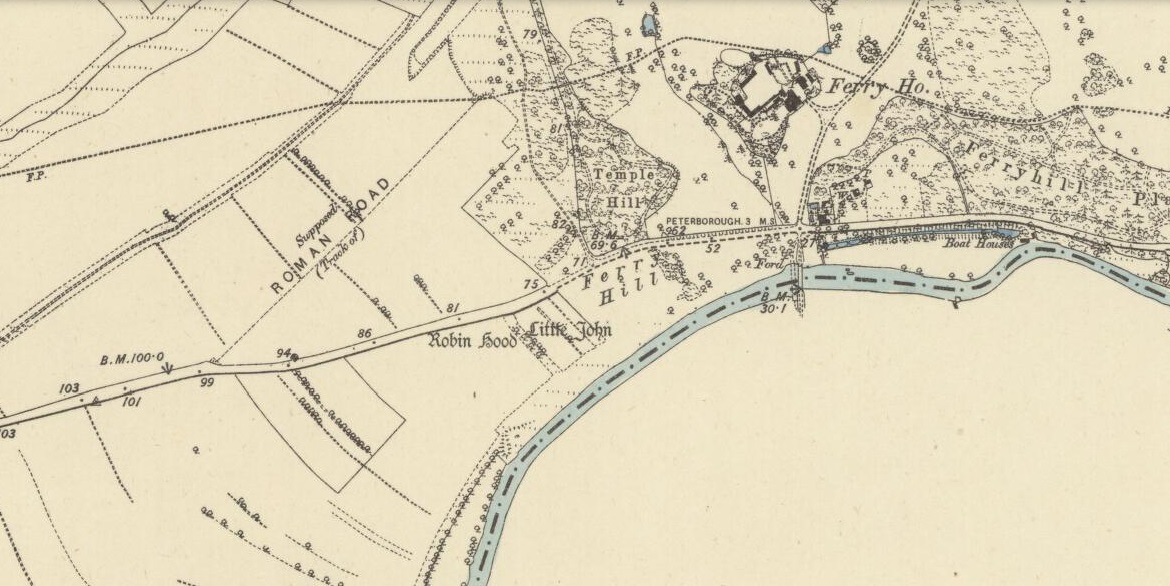
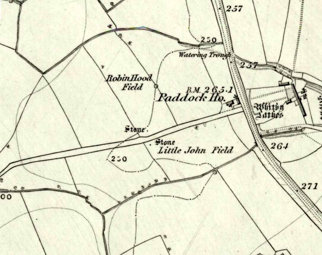
‘Standing Stones’: OS Grid Reference — TL 1395 9839
Also Known as:
St. Edmund’s Stones
Archaeology & History
1885 OS-map of the site
A curious and intriguing site with as many questions about its nature as there is its folklore. Moved around by the conniving fuckwit politicians from Huntingdonshire, to Northants to Cambridge nowadays, one wonders where those fools will place it next! Listed by a number of archaeologists as prehistoric standing stones, it seems pretty obvious from photos and the descriptions of many amateur students that—unless some original monoliths have been reworked a few centuries back—the narrative given by local historian W.H.B. Saunders (1888) outlines their more probable origin and history. That’s not to say that the stones aren’t old—just not that olde…. Mr Saunders reasoned that they were dug and transported from more than 5 miles northwest of their present spot, telling that:
“Nothing can rob the stones of their undoubted antiquity. The Barnack quarries have been exhausted for the last 600 years at least. It is evident therefore, that the stones were placed in their present position at a time when the Barnack quarries were being worked. That would be in the days of Robin Hood, and also when the Abbey of St. Edmund’s Bury, built of Barnack stone, was being erected.”
His words make sense when you look at the stature of the monoliths in question. They’re cut and squared to the edges, with Robin Hood being the taller of the two stones, about 30 feet southwest of the Little John stone. They have been written about quite extensively by historians down the centuries, from William Camden onwards. One early account of the stones was written by Symon Gunton (1686) who told:
“I find in the charter of King Edward the confessor…that the abbot of Ramsey should give to the abbot and convent of Peterburgh 4000 eeles in the time of Lent, and in consideration thereof the abbot of Peterburgh should give to the abbot of Ramsey as much freestone from his pitts in Bernack, and as much ragstone from his pitts in Peterburgh as he should need.
“Nor did the abbot of Peterburgh from these pits furnish only that but other abbies also, as that of St. Edmunds-Bury: in memory whereof there are two long stones yet standing upon a balk in Castor-field, near unto Gunwade ferry; which erroneous tradition hath given out to be draughts of arrows from Alwalton church-yard thither; the one of Robin Hood, and the other of Little John; but the truth is, they were set up for witnesses, that the carriages of stone from Bernack to Gunwade-ferry, to be conveyed to S. Edmunds-Bury, might pass that way without paying toll; and in some old terriars they are called St. Edmund’s stones. These stones are nicked in their tops after the manner of arrows, probably enough in memory of S. Edmund, who was shot to death with arrows by the Danes. The balk they stand upon is still call’d St Edmund’s Balk. They are supposed to be the petrify’d arrows of those two famous archers.”
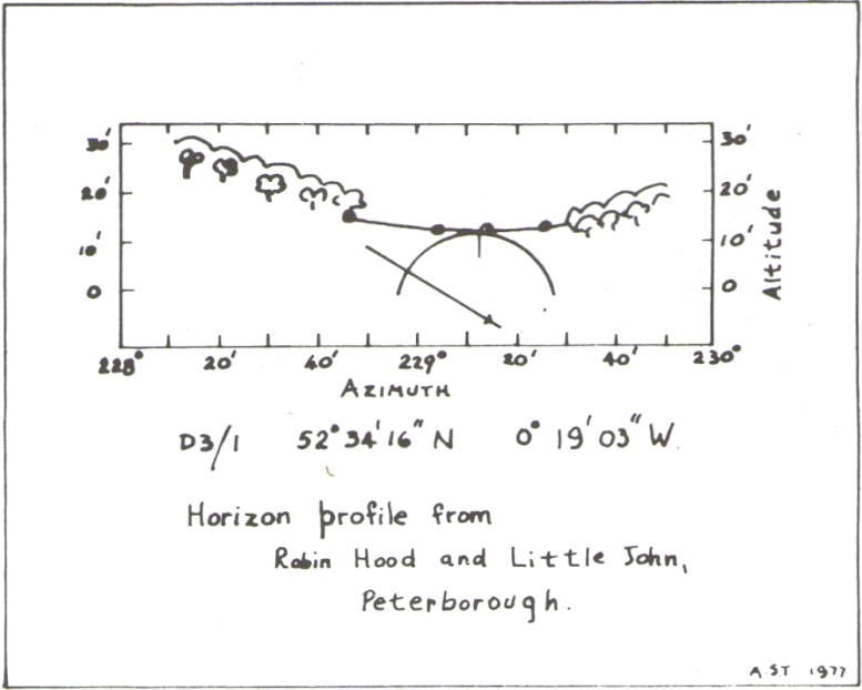
Thom’s sketch showing his midwinter alignment
These traditions have subsequently been copied by all local historians. So it is something of a curiosity to find our archaeologists—from Clarke (1960) and F.M. Pryor (1972) to Aubrey Burl (1993)—to cite these as prehistoric monoliths. My suspicions as to their reasons relates to the folklore of the stones which are echoed at many truly prehistoric places like the Devil’s Arrows, etc. The nature of the tale is an aboriginal creation myth, relating to the formation of sites as understood in animistic mythic structures. But this archaeological misunderstanding brought the more scientific mathematical mind of Alexander Thom (1990:1) here in the 1980s where coincidence showed a common astronomical alignment. Thom wrote:
“Clearly visible from the site, at an azimuth of 229°.22 is the lowest point of a low saddle on the horizon. The col, Fig.1 (above), subtends an arc of about 0°.67 of azimuth, observed minimum altitude 0°.21. For an estimated temperature of 44°F, correction for refraction at sunset is about 0°.54, and for solar and semi-diameter and parallax of respectively 0°.27 and 0°.002, the ‘observed’ declination is found to be -23°.92, which indicates a date of about 1860 BC.
“No presently obvious horizon marker was evident upon inspection of the open fields forming the horizon, but this does not mean that a foresight was never erected. Without the evidence of a foresight it cannot be claimed that the two stones were placed for accurate calendrical reasons, but undoubtedly they indicate by themselves the winter solstice.”
The folklore may indicate the possibility that these two medieval standing stones replaced earlier ones, but no remains of such relics exist today.
References:
Burl, Aubrey, From Carnac to Callanish, Yale University Press 1993.
Clarke, R. Rainbird, East Anglia: Ancient Peoples and Places, Thames & Hudson: London 1960.
Gover, J.E.B., Mawer, A. & Stenton, F.M., The Place-Names of Northamptonshire, Cambridge University Press 1975.
Grinsell, Leslie V., Folklore of Prehistoric Sites in Britain, David & Charles: London 1976.
Gunton, Symon, TheHistory of the Church of Peterburgh, Richard Chiswell: London 1686.
Mee, Arthur, Bedfordshire and Huntingdonshire, Hodder & Stoughton: London 1973.
Morton, John, The Natural History of Northampton-shire; with Some Account of the Antiquities – 2 volumes, R. Knaplock: London 1712.
Pryor, F.M., Prehistoric Man in the Nene Valley, Nene Valley Research: Peterborough 1972.
Saunders, W.H.B., Legends and Traditions of Huntingdonshire, Simpkin Marshall: London 1888.
Standing Stones (destroyed?): OS Grid Reference – NZ 9171 0952
Also Known as:
Robin Hood’s Pillars
Archaeology & History
The 2 stones on 1853 map
References to these old standing stones are scarce—at least in archaeology books anyway. Even the usually diligent masters of Burl (1993) and Thom (1990) missed them! But thankfully our folklorists and antiquarians with their keen interest in popular culture have written about these long lost monoliths, which could once be seen in fields just a mile or so south of Whitby town.
The earliest known account of the site is as the “Robyn-Hood-stone” in records dating from 1540 CE cited in the Cartularium Abbathiae de Whiteby (1881). It was later described in land registers in 1713 and the fields in which they stood were—and still are—respectively known as Robin Hood’s Close and Little John’s Close.
These Whitby monoliths—like their namesakes in Northamptonshire— weren’t too big. In Mr Young’s (1817) early description, when the stones were still visible, he told how Robin Hood’s stone was “a stone pillar about a foot square and four feet high”, and Little John’s Stone was “a similar pillar about two-and-a-half feet high.” Mr J.C. Atkinson, the editor of the Cartularium (1881), also told that the two stones were “still in situ in the earlier part of the present century,” continuing:
“Both stones have now been removed, and are, I was informed, set up again near the enclosing fence of the field in which they stood. Almost beyond question , like the other monoliths of the district, they marked the site of ancient British interments.”
So—do the remains of these old stones still exist somewhere close by as J.C. Atkinson said, either in the walling, as a gatepost, or just pushed over and now covered in grass (like the long lost Thief Thorne standing stone near Addingham)? Are any northern antiquarians living close by who might enable their rediscovery?
Folklore
A number of writers exploring the mythic histories of Robin Hood have included this site in their surveys, usually repeating the earlier creation myths about them that could be heard in popular culture. The Whitby historian George Young (1817) told the tale:
“According to tradition, Robin Hood and his trusty mate, Little John, went to dine with one of the Abbots of Whitby, and, being desired by the Abbot to try how far each of them could shoot and arrow, they both shot from the top of the Abbey, and their arrows fell on the west side of Whitby Laithes, beside the lane leading from thence to Stainsacre; that of Robin Hood falling on the north side of the lane and that of Little John about a hundred feet further, on the south side of the lane.”
Whitby folklorist P.S. Jeffrey (1923) took this myth literally, saying how the distance of the arrows fired by the respective folk heroes was “scarcely credible, as the distance in each case is about a mile-and-a-half.” However, the earlier historian Lionel Charlton (1779) thought the incredible feat quite credible!
The distance between the Abbey and the stones is 1.36 miles (2.2km); but it may be that the direction related in the tale was more important than the distance, as the alignment between the two sites runs northwest to southeast—or southeast to northwest, whichever you prefer!—and may relate to an early astro-archaeological alignment. Might…..
References:
Anonymous, “Robin Hood in Yorkshire“, in Yorkshire Folk-Lore Journal – volume 1, T.Harrison: Bingley 1888.
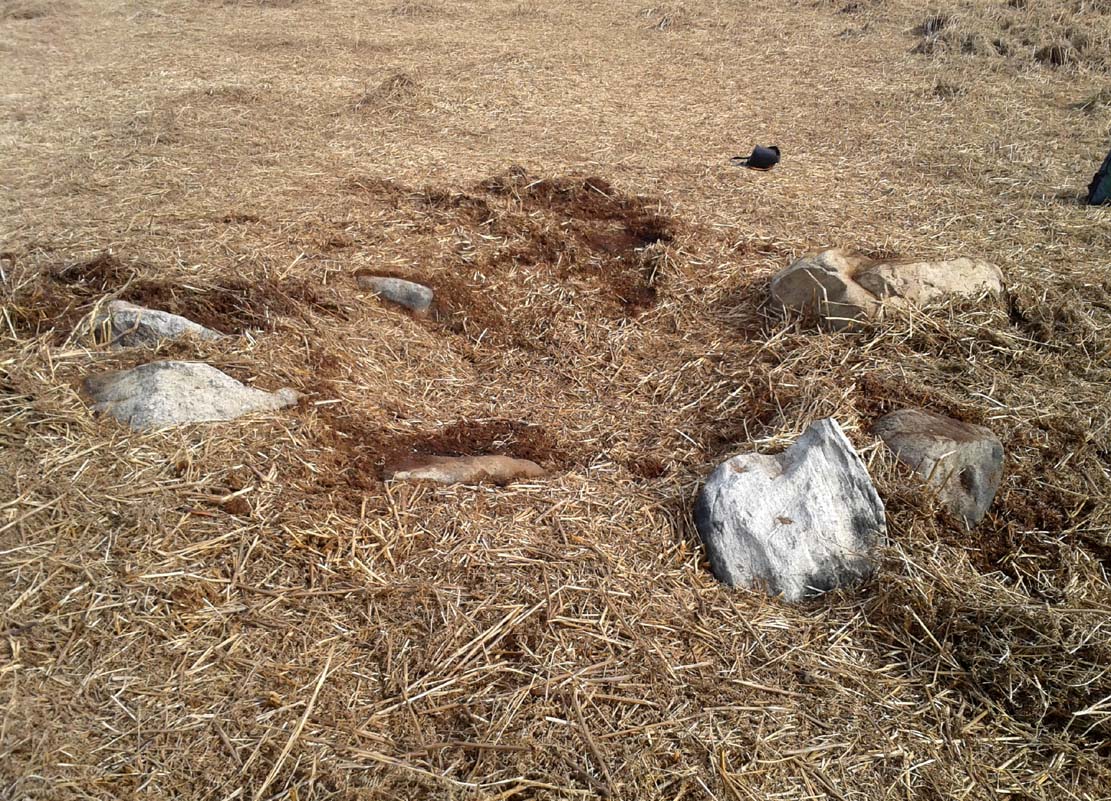
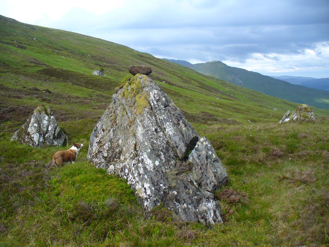
From the double-ring that is the Brackenhall Circle at Shipley Glen, go up the road towards the hills and seek out the cup-marked Glovershaw Quarry Stone. Shortly before this, notice the small trees close the quarry edge. From here, walk straight east, as if you’re going toward Baildon Hill. Barely 10 yards into the bracken you’ll notice this small ring of stones (best looked for in winter before the bracken grows back – otherwise you’ve no chance!).
Archaeology & History
This site was explored when James Elkington, Paul Hornby and I came across it on Wednesday, 11 March 2015, after returning from a short excursion to look at some of the petroglyphs on Baildon Hill.
Ostensibly it is a small ring of stones comprising of at least 7 large rocks that are set deeply into the peat and bracken-mass, with a small eighth movable stone on the northern side. It seemed likely that another, larger rock was beneath this small portable rock, but we didn’t dig into the vegetative mound to explore this. The most curious thing about the ring of stones was that it measured barely 4 yards in diameter. My initial thought was that this was a previously unrecorded cairn, but there seemed to be no internal mass of rocks in the centre that characterize such monuments and which you’d expect in a ring of this size – meaning that it may be, perhaps, the smallest stone circle in Britain. It’s a pretty good contender at least! (the stone circle known as “Circle 275” at Penmaenmawr in Wales is of similar size to this one, but with less stones in that ring)
Close-up of the stones
It would be good if the regional archaeologists could give this site their attention and clean it up to see exactly what lays beneath the boscage. Close by are several cup-marked stones and a couple of other larger cairn circles.
The name of the site came after I almost stood on a hibernating toad, found beneath the bracken-mass right at the edge of one of the stones. I carefully picked him up and reburied him in another spot close by, leaving him (perhaps) to ponder his venture into the bright daylight of consciousness! Mr Hornby promptly declared – “these are the Toad Stones!” – and it stuck.
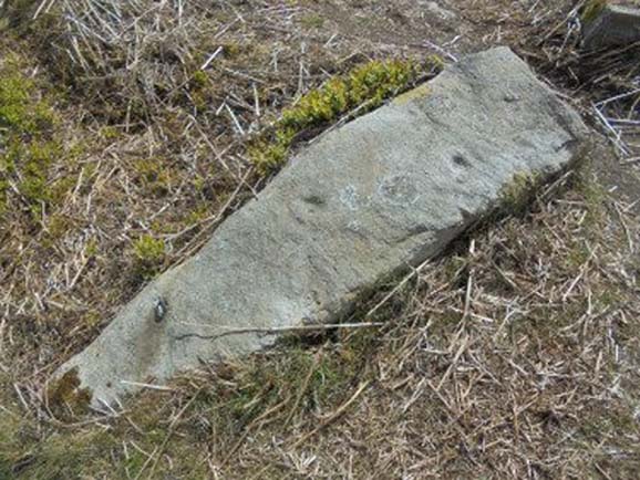
Go all the way up and through Heptonstall village until you reach the hamlet of Slack, by the road junction. From here walk down the road as if you’re going back into Hebden for less than 200 yards, then take the footpath on the left downhill and walk along. After a couple of stiles, keep a keen eye on the walling where the holly trees are, above the tree-line of Hardcastle Crags. You’ll see it soon enough!
Archaeology & History
Slack Bottom stone
Arguably the best-named standing stone in Britain, it was first discovered by Absalom Voist in the late 1990s (and first described in my Old Stones of Elmet), hiding away in the more modern walling, beneath a holly tree. But the stone itself is very nicely eroded and seems of good age, aswell as being a good near-six-foot tall specimen of a standing stone, just above the tree-line south of Hebden Dale. The stone gets its name from the fact that it’s at the bottom end of Slack village (which is actually called ‘Slack Bottom’ – with a house-sign there above the door to prove it!). It may be part of what was originally some original Iron Age walling instead of an authentic standing stone — tis hard to say really — but it’s a nice stone nonetheless. David Shepherd (2003) named this stone as ‘Dawson City Field’ in his later survey of megaliths in upper Calderdale.
Not far from here, along the edge of the woodland, is the little-known remains of an old cross-base which I think has eluded all previous surveys. Next time I’m up here, I’ll try remember to get some photos of the place!
References:
Bennett, Paul, The Old Stones of Elmet, Capall Bann: Milverton 2001.
Shepherd, David, ‘Prehistoric Activity in the Central South Pennines,’ in Proc. Halifax Ant. Soc., 2003.
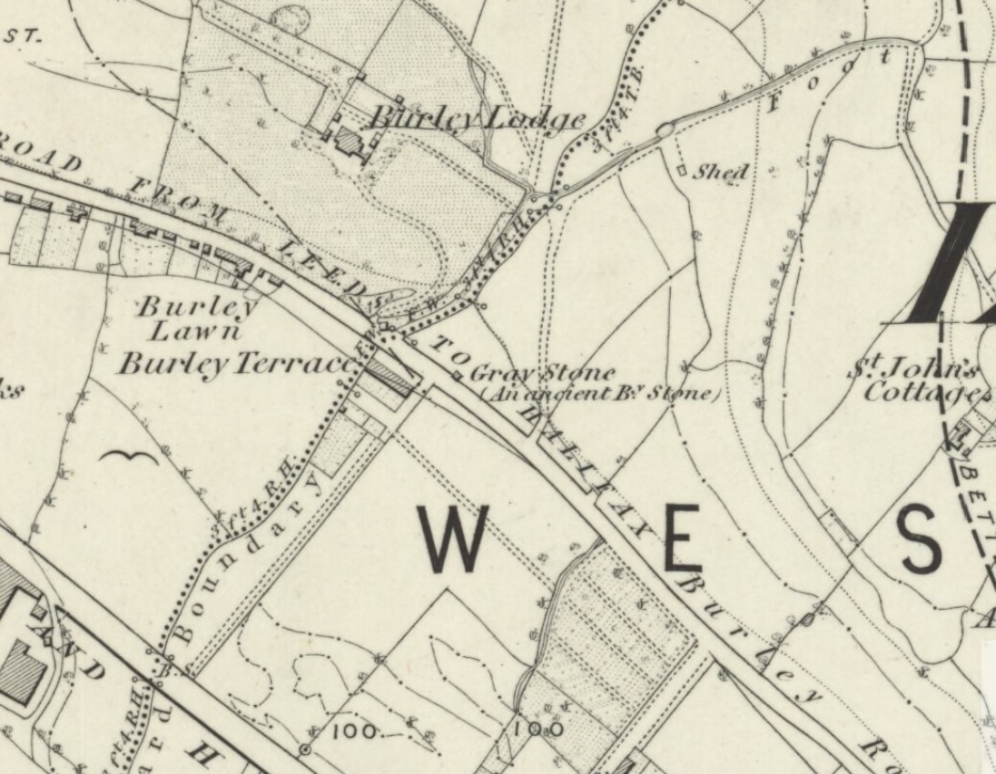
Originally located at SE 28449 34364, the site is now to be found halfway along Westfield Road, where it meets up with Hollis Place, along the footpath at the back of the school, set back against the walling. A plaque by the rock kinda gives the game away!
Archaeology & History
Gray Stone on 1852 map
The large vandalised stone you see here—sprayed-painted quite eloquently it has to be said!—is apparently a replica of the old stone which could once be found about 300 yards northwest of here. Typifying stones of this name—gray, grey and variants thereof—the original Gray Stone was an old boundary marker (Smith 1956), and the last reference to it as an archaeological site was by James Wardell (1853), who even in his day said that it was “almost buried in the ground, on the Burley Road.” It is shown on the first OS-map by the roadside, close to the junction of Woodside View and Burley Road, but was said to have been removed at the beginning of the 20th century and moved to its new and present position. However, somewhere along the line, the original stone has been destroyed and the thing that we see today has taken its place.
The original Gray Stone may have been a standing stone, but we cannot be certain about this. The present boulder stands about four feet tall and is a rather fat-looking standing stone. You can just about squeeze round the back of it, around which is an incised line which cuts around the stone – but this obviously quite modern. A plaque stands in front of the stone, telling its brief history. (if anyone can send us some photos of the site that would be great – I’ve gone and lost mine, somehow!)
Folklore
A creation myth of this site tells it to have been made by a giant, who threw the Gray Stone from the appropriately named Giant’s Hill (a supposed old camp, now destroyed), less than a mile southeast of here: an alignment which corresponds closely to the midsummer sunrise. In throwing it, he was said to have left the indentations of his finger-marks in the rock – thought to have been cup-markings. Examples of other cup-and-ring stones occur a short distance west, at Kirkstall.
References:
Bennett, Paul, The Old Stones of Elmet, Capall Bann: Milverton 2001.
Smith, A.H., English Place-Name Elements – 2 volumes, Cambridge University Press 1956.
Wardell, James, The Antiquities of the Borough of Leeds, John Russell Smith: London 1853.
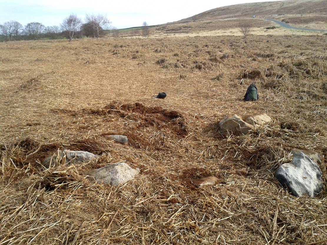
There is no written history of this site; only the quiet murmurings of a few locals whose families go back to when the English came and destroyed the people and their lives in the 18th and 19th century in the ethnic cleansing we known as The Clearances. As with the Darach nan Sith (the Oak of the Fairies) a few miles away, the local traditions were lost, and ancient monuments destroyed. Thankfully, due to the remote location of this site, its status remains….
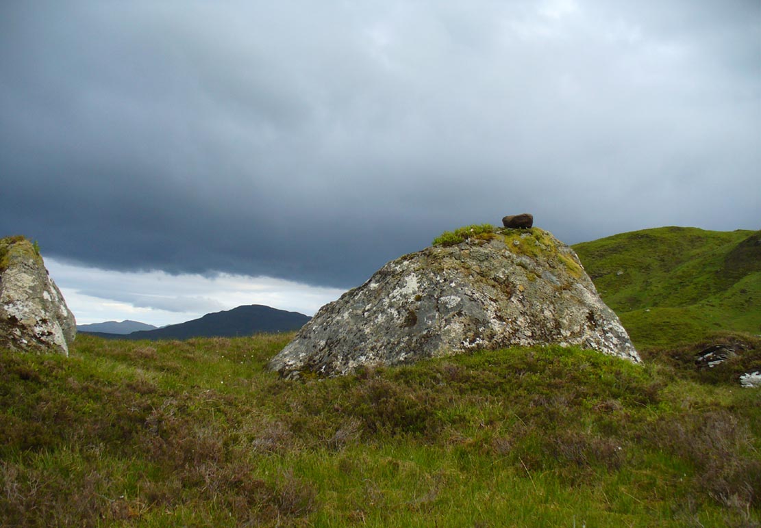
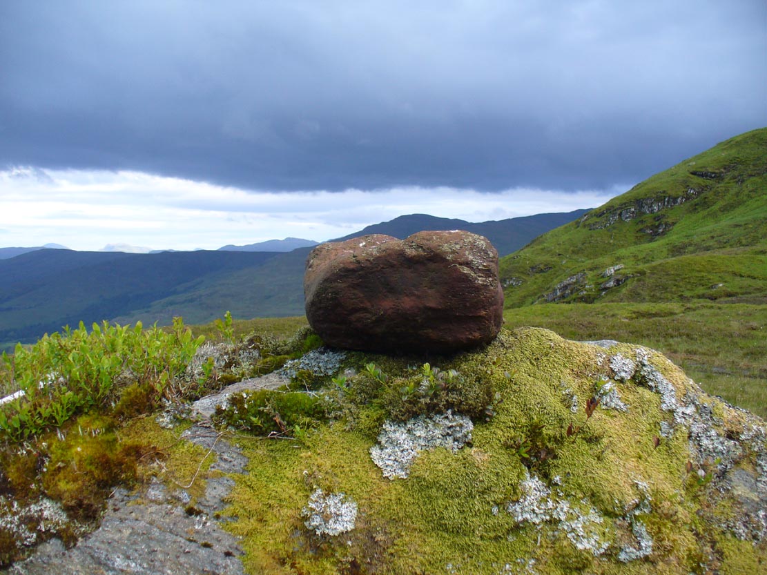
It is found 2000 feet up, near an old derelict village (english academic romancers term it as ‘sheilings’). An ancient track and stone bridge runs over the burn nearby, place-names evidence tells of a prehistoric tomb a few hundred yards west, and there’s a dispersal of forgotten human evidences scattering the south-side of the mountain all along here. The clach (stone) sits on the very top of a large earthfast rock; is an elongated loaf-sized smooth red-coloured stone, about 14 inches long and 8 inches wide, and of a different type and much heavier than the local rock hereby. It is said to have been a healing stone, used in earlier times to cure warts and other ailments.
Folklore
The Wart Stone itself
My first venture here was, like many in this area, amidst a dreaming. Those who amble the hills properly, know what I mean. I cut across the mountain slopes diagonally, zigzagging as usual, always off-path, resting by mossy stones and drinking the waters here and there. My nose took me to the mass of giant rocks hedging into the higher regions of Allt Ghaordaidh: a pass betwixt the rounded giants of Meall Ghoaordie and Meall Cnap Laraich, where only eagles and Taoist romancers might roam.
The great rock comes upon you pretty easily. Approaching it for the first time I wondered whether there might be petroglyphs on or around it, but the rich depth of lichens and its curious crowning elongated stone stopped any further thought on the matter. The setting, the eagles, the colour of day and the fast waters close by, stole all such thoughts away. In truth I must have walked back and forth and near-slept below the place for an hour or two before I gave way to rational focus! And then my curiosity got even more curious.
“This must be the place,” I mused, several times.
As you can see in the photo, a large natural earthfast boulder, six feet high or more, like a giant Badger Stone covered in centuries of primal lichens, has a large deep red-coloured stone on its very crown. The stone is unlike any of the local rock and is very heavy. I found this out when trying to prize it from its rocky mount, dislodging it slightly from the seeming aeons of vegetation that held it there. But the moment I moved it, just an inch or so above its parent boulder, a quiet voice inside me rose sharply into focus.
“You shouldn’t have done that!”
The Wart Stone. looking east
Quickly I set it back into place, shaking my head at what I’d done. One of those curious feelings you get at these places sometimes wouldn’t leave me, however much I tried to shake it off. …Silly though it may sound, the echoes inside kept saying over and over to me, “you’re gonna get warts now you’ve done that!” Logically, of course, that made no sense whatsoever. I’d only ever had one wart in my life, a couple of decades ago. And yet, a few days later, one of the little blighters emerged on my finger! So there was only one thing for it! If this was a Wart Stone, I should revisit it again and place my afflicted finger back onto the wart and ask it to be taken back into the stone.
A week or so later, I clambered all the way up the mountainside again and asked the place to forgive my stupidity and take back the wart. Apologising to the spirit of the stone, I rubbed my finger on the curious coloured rock and, I have to be honest, didn’t know what to expect.
I spent the next few hours meandering here and there over the hills and cast the thought of the Wart Stone back into my unconscious. But a few days later it had started shrinking – and within a week, had completely gone! This faint relic of an older culture, this Clach na Foinne had performed its old ways again, as in animistic ages past…
Cup-and-rings on gatepost (photo credit, Dave Whittaker)
From Ilkley, follow the same directions as if you’re going up to the superb Swastika Stone. Keep walking on the footpath, west, for 65 yards (59m), then walk into the heather on your left. Barely 5 yards in, you’ll see this fallen standing stone or gatepost.
Archaeology & History
First described in one of Stuart Feather’s (1964) old rambles, I first saw this stone in my late-teens and was as puzzled by it then as I am today. Upon an obviously worked stone that may once have stood upright (or was intended to do), two faint and incomplete cup-and-rings were carved – but when exactly? If this stone was cut from a larger rock into its present shape, were the petroglyphs already on it, or were they done when the ‘gatepost’ was created?
It was first described in one of Stuart Feather’s (1964) rambles up here and later included in Hedges’ (1986) survey, where he told it to be a, “recumbent gatepost with one cup with almost complete ring and one cup with vestigial ring.” Boughey & Vickerman’s (2003) survey added little more. And when a group calling itself Carved Stones Investigation got itself about £250,000 to “investigate” the Ilkley petroglyphs, I was hoping that they could have at least turned this stone over to see if other carvings were on the stone – but they just revisited all those found by others, made a new list, and took the money to be honest (no website and no book – as they should’ve done). Thankfully, local folk are having a look at this and others and doing the work they should have. Check it out when you’re next up at the Swastika.
References:
Bennett, Paul, Megalithic Ramblings between Ilkley and Baildon, unpublished: Shipley 1982.
Boughey, Keith & Vickerman, E.A., Prehistoric Rock Art of the West Riding, WYAS: Wakefield 2003.
Feather, Stuart, “Mid-Wharfedale Cup-and-Ring Markings: no.26, 27, 28 – Black Pots, High Moor, Silsden, near Keighley,” in Cartwright Hall Archaeology Group Bulletin, 9:10, 1964.
Hedges, John, The Carved Rocks on Rombalds Moor, WYMCC: Wakefield 1986.
Acknowledgements: Huge thanks to Dave Whittaker for the photo. Good luck with the plans fellas.
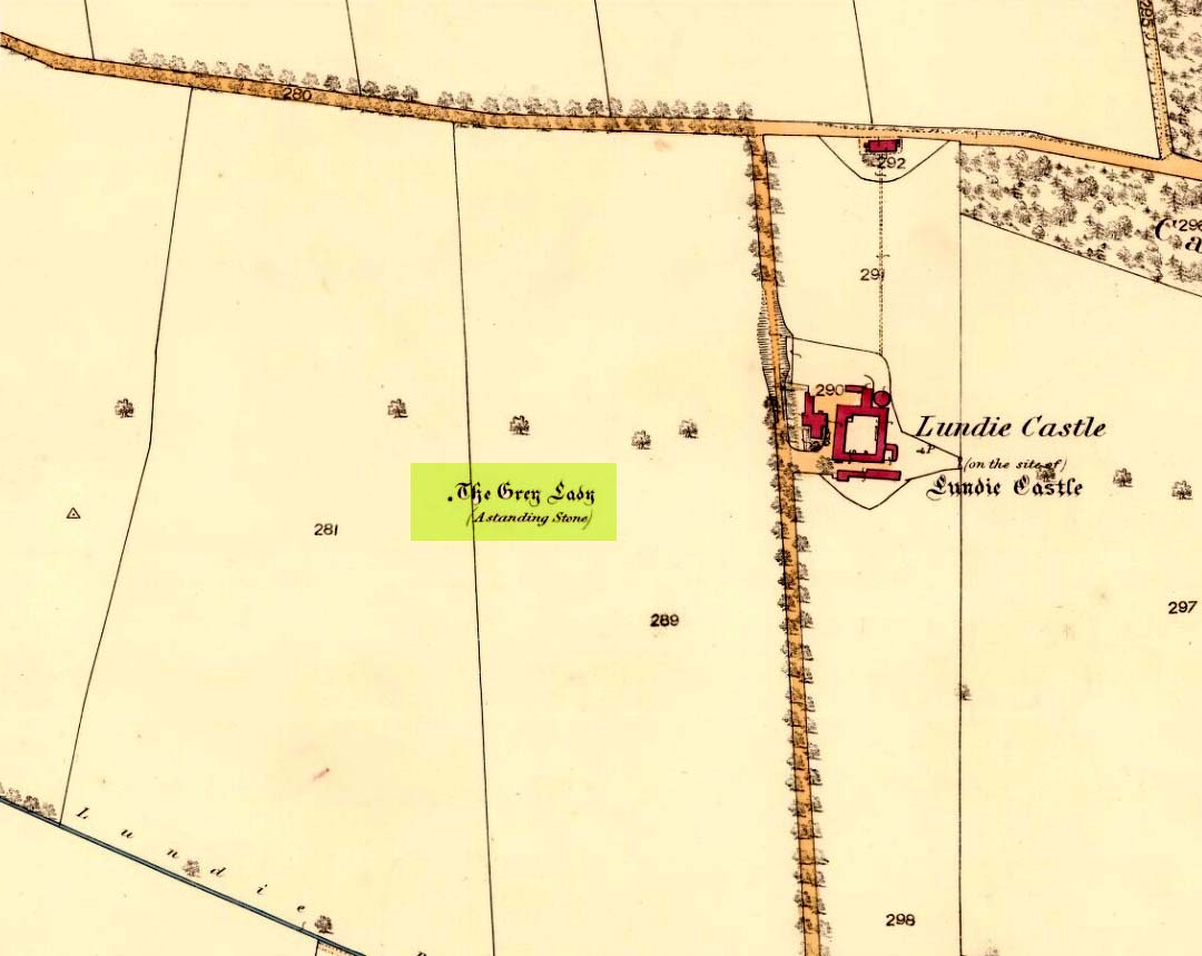
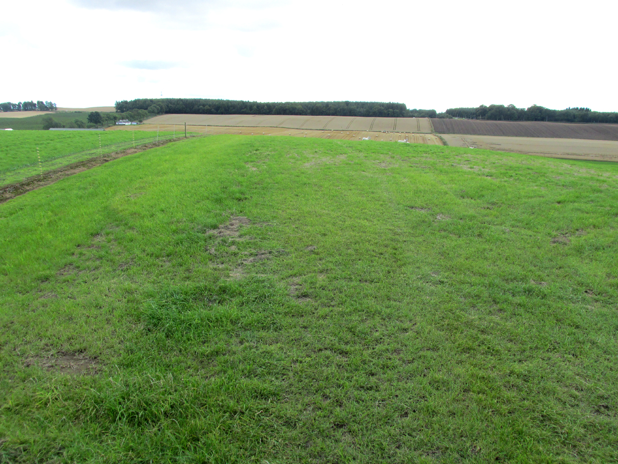
The site of the stone is on the top of a ridge due west of Lundie Castle and is best approached from the minor road between Lundie and Denhead, but at the time of my site visit a steel gate had been erected across the field just before the site of the stone together with a large festoon of electric fencing, which I did not cross.
Archaeology & History
The Grey Lady stood on the near grassy horizon
The Ordnance Survey name book describes the stone, the informants being Mr. Pattullo junior and Mr. Bett of Pitermo:
“This name is applied to a Standing Stone a little to the west of Lundie Castle. It is about 4 feet high, between two & three broad & rather a Kidney Shape. …Some think of druidical origin, but young Pattullo intends to blast it shortly“.
The rough grass probably marks where she stood.
And indeed it seems the feckless youth did have his wicked way with The Grey Lady, who had been a landmark for millennia, for she sadly no longer exists. In view of the folklore attaching to the stone, it may be worth speculating whether the kidney shape denoted a lunar symbolism for the stone.
Folklore
The OS name book states:
“The ladies of Lundie Castle have romance connected with it – that a white lady is to be seen walking round it on a certain night of every new moon.”
Reference:
Ordnance Survey Name Book; Forfarshire (Angus) volume 66 (1857-61)