After standing at the same spot for 3000 years or more, near the beginning of the 19th century this stone circle was destroyed by the self-righteous christian cult that was rampaging its way through cultures far and wide. After all, they needed to rid the area of local traditions and “improve” the locals, whether they liked it or not! Thankfully however, one of their creed—a reverend Ferdinand Ellis: minister of the parish for forty years—recorded its destruction in the New Statistical Account between 1834-45. Amongst a variety of important traditional monuments that once existed hereby,
“A Druidical place of worship anciently stood about the middle of the churchyard or burying ground. It consisted of a circle of twelve upright large granite stones from Benochee, which were overturned when the first Christian temple was erected. One of these was taken up in 1821 and now remains above ground, near the spot where it was taken up. The other eleven are still underground. This is proof that the first christian missionaries, in this country, erected their places of worship as near as possible to the holy hills of the heathens, that the people might be more easily persuaded to assemble there.”
‘Persuaded‘ being a very broad term indeed when it came to the land confiscation of indigenous folk…
The stone that Ellis said “was taken up in 1821 and now remains above ground” was gone when Fred Coles (1902) surveyed the site, but he told how an earlier antiquarian and writer for the Scottish Society of Antiquaries, J.G. Callander, lived nearby, and who was
“told by the aged sexton, Florance, that he many a time came across a great stone, when preparing graves, and that he had himself blasted these more than once.”
It seems that all trace of this single stone, and the rest of them, either still lay in the ground or were used for local building material.
When John Barnatt (1989) came to add this circle in his corpus, for some reason he postulated that
“the number of stones suggest it was a recumbent stone circle”,
…that is: a stone circle possessing one large stone in the ring that’s laid down with two standing stones either side. However, there seems no real evidence to show that this was the case.
References:
Barnatt, John, Stone Circles of Britain – volume 2, BAR: Oxford 1989.
Browne, G.F., On Some Antiquities in the Neighbourhood of Dunecht House, Aberdeenshire, Cambridge University Press 1921.
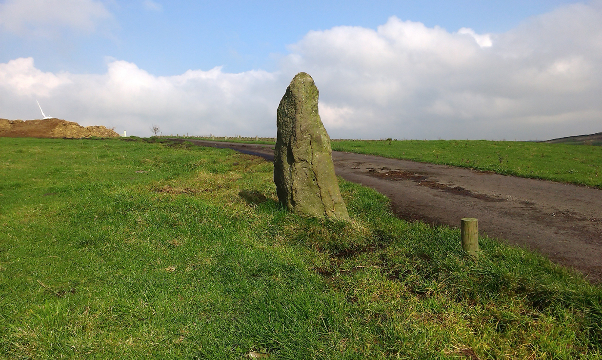
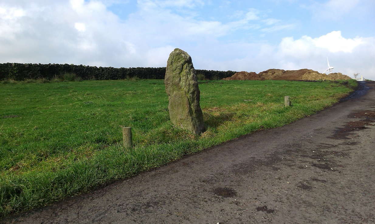
From Lochgilphead, take the A816 road north for several miles (towards the megalithic paradise of Kilmartin), keeping your eyes peeled for the road-signs saying “Dunadd.” Turn left and park-up. Instead of walking up the craggy fortress, follow the road-track to the house and, alongside the River Add, you’ll see the standing stone in the well-mown garden on your right.
Archaeology & History
As a monolith within the Kilmartin Valley complex, this is a slight, almost gentle standing stone, missed by most when they visit the other larger sites in Argyll’s Valley of the Kings. Set upright close to the gentle winding River Add and only a few yards from the ancient ford that bridged the waters beneath the shadow of Dunadd’s regal fortress, the late great Alexander Thom (1971) wrote about it in his exploration of lunar alignments found at other nearby standing stones. This one however, was 3° out to have any astronomical validity.
Described only in passing by a number of writers, the greatest literary attention it has previously been afforded was by the Royal Commission lads (1988), whose notes on it were short:
“An irregularly-shaped block of stone, 1.35m high and 1.35m in girth at the base, is situated 25m S of Dunadd farmhouse, it is aligned NNW and SSE, and the top the SSE edge appear to have been broken off.”
…My first visit here was when I lived north of Kilmartin and each time I found the same ‘gentle’ feeling, in all different weathers: a most unusual phenomenon, as there tends to be changes in psychological states between rain, sunshine, frosts, dark night and mists. But there was a consistency of subtlety; a regularity in genius loci—probably due to its proximity to the River Add, the lowland tranquility below the crags. It’s a wonderful little place. Well worth visiting if you go to Dunadd.
References:
Campbell, Marion, Mid-Argyll: An Archaeological Guide, Dolphin Press: Glenrothes 1984.
Lane, Alan & Campbell, Ewan, Dunadd: An Early Dalriadic Capital, Oxbow: Oxford 2000.
Royal Commission on the Ancient & Historical Monuments of Scotland, Argyll – Volume 6: Mid-Argyll and Cowal, HMSO: Edinburgh 1988.
Ruggles, Clive L.N., “A critical examination of the megalithic lunar observatories,” in Ruggles & Whittle, Astronomy and Society in Britain, BAR: Oxford 1981.
Ruggles, Clive L.N., Megalithic Astronomy, BAR: Oxford 1984.
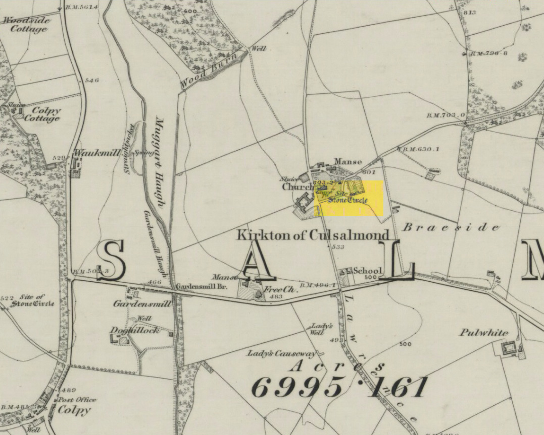
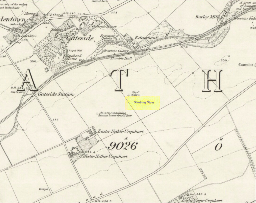
Turn off the A91 road at Gateside and go down Station Road, crossing the old railway line at the bottom. From here, cross the fields to your left and the site of the circle will be found in the field to the north east of Easter Nether Urquhart Farm.
Archaeology & History
Marked on the 1856 6″ Ordnance Survey map as a “standing stone,” earlier references record this as being the survivor of a stone circle. Not listed in Aubrey Burl’s (2000) magnum opus, this circle was on the edge of the site of a major battle between the Romans and the native defenders, and large amounts of human remains have been found in the vicinity. Referring to an adjacent cairn, Lieutenant-Colonel Miller wrote in 1829:
“A very fine Druid’s Temple stood on the south side of it, consisting of seven very large stones. All these were blasted with powder and removed, except half the one of them, which still marks the spot.”
Of the same cairn, the Reverend Andrew Small wrote in 1823:
“This cairn stood a little north of an ancient Druids’ temple, only one stone now remaining, out of ten of which it formerly consisted.”
The Ordnance Survey Name Book for 1853-55 imparts the following:
“This standing Stone is about 13 chains on the South side of the River Eden opposite Edensbank but whether it is the remains of a druid’s temple or set up to mark something relative to the battle contested between the Romans and Caledonians according to Messrs. Miller & Small, it is difficult to determine. It stands about 4 feet 10 inches high and its sides are about 2 feet broad…many of the inhabitants consider it to have been a druid’s temple…”
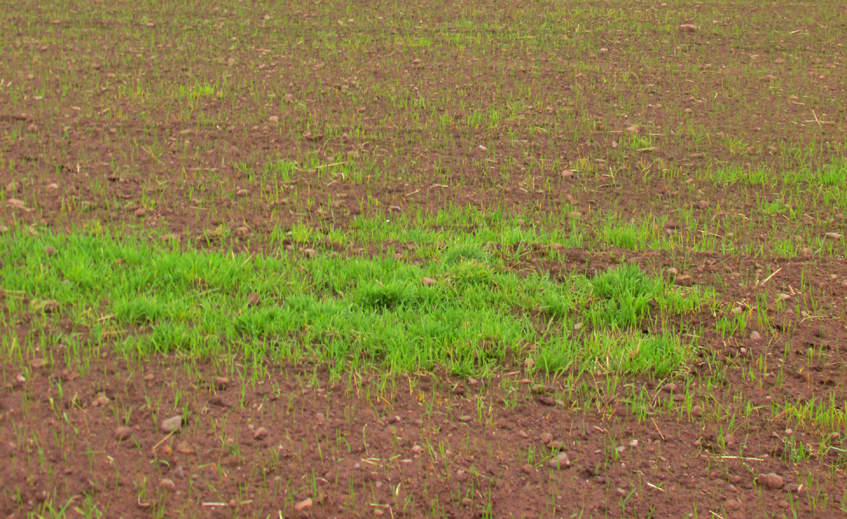
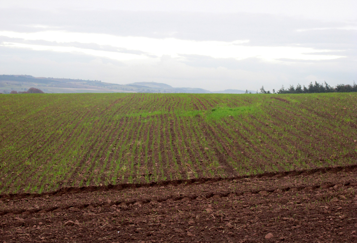
A close-up of the sitePosition of the circle, evident in crop-growth
J.S. Baird of Nether Urquhart informed an Ordnance Survey officer in 1956 that the remaining stone was broken up and removed around 1952, and measured 5 feet high with a girth of 9 feet at the base. Near the top of the stone, on the south-side were two slight cracks weathered to suggest a simple incised cross.
On the day of my November field-visit the winter barley was sprouting and it was interesting to see how much better it was growing at the place where the remaining stone had stood.
Burl, Aubrey, The Stone Circles of Britain, Ireland and Brittany, Yale University Press 2000.
Miller, Lieutenant-Colonel, “An Inquiry respecting the site of the battle of Mons Grampius (Read 27th April 1829 and 25th January 1830),” in Proceedings of the Society of Antiquaries of Scotland, Volume IV, 1857.
Small, Reverend Andrew, Interesting Roman Antiquities Recently Discovered in Fife Ascertaining the site of the Great Battle fought betwixt Agricola and Galgacus, John Anderson & Co: Edinburgh 1823.
Take the directions to the hugely impressive Dunruchan A standing stone. Walk directly south, over the gate and follow the fence straight down the fields, crossing the burn at the very bottom. Walk over the boggy grassland and start veering uphill, southeast. You’ll notice the land goes up in geological ‘steps’ and, a few hundred yards up, a small standing stone pokes up on the near skyline ahead of you. Head straight for it!
Archaeology & History
This small standing stone was first noted after a quick visit to the major Dunruchan megalithic complex in the summer of 2016. Photographer James Elkington was taking images of the landscape and the standing stones when he noticed a stone on the horizon a half-mile away. As we were in a rush, he took a couple of photos from different angles on the way back to the car—both of which looked promising. And so, several months later, we revisited the site again. Lisa, Paul and Mr Fukner and I meandered up the geological steps of the hillside until we reached the site in question.
Looking northwestLooking northeast
Standing just over four-feet tall, this solitary stone overlooks the megalithic Dunruchan complex a half-mile or so to the north and northwest. Like the Dunruchan C monolith, this smaller upright is conglomerate stone. Paul Hornby noted what may be a single cup-marked stone roughly 100 yards east along the same ridge. (Please note that the grid-ref may be slightly out by perhaps 50 yards or so at the most. If anyone visits and can rectify my ineptitude on this matter, please let me know.)
From Colne or Laneshaw Bridge, head up the Skipton Old Road which heads up towards Bleara Moor (with its prehistoric cairns). Way before that though, about 100 yards before you reach the Black Lane Ends pub, turn left up the track to Jerusalem Farm. Go past it, through the gates and keep on the track until, another coupla hundred further uphill, you’ll see it on the skyline ahead of you…
Archaeology & History
There appears to be no previous reference to this standing stone, found high upon the lonely ridge beside the old track that runs between Laneshaw Bridge and Kelbrooke and Earby. Well eroded on all sides, it isn’t shown on the early or recent maps and has evaded the archaeological registers of the area (but this is Lancashire, where archaeology has been damn lazy on the county’s prehistoric relics until very recently). It may have been laid down for an age, only recently resurrected—we simply do not know. Standing nearly five-feet tall, on its top western face is what looks like a very faded cup-marking, but this may be a fortuitous Rorscharch. There are no marks or holes in the stone to indicate it has ever been used as a gatepost.
Looking far into the eastLooking northwest
I was guided here by the northern antiquarian and stonemason Chris Swales a few weeks ago and was quite taken aback by its position in the landscape—which is outstanding! Apart from being blocked to the west by the rise of the Great Edge, the views to the north through east and south and superb. On the far eastern skyline rises the legendary Hitching Stone, between which is the seemingly cairn-less Knarrs Hill.
Further north along the track we reach the old Dissenter’s Well and its moving companion, the Tom Cross (which has marked different parts of the Lancashire and Yorkshire boundary). Other than this, we know nothing more. An intriguing spot and well worth visiting!
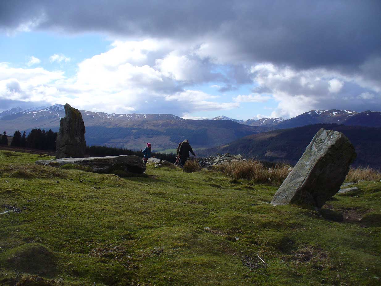
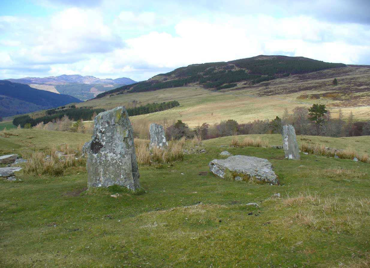
From Kenmore, take the minor road on the south-side of Loch Tay for 1½ miles (2.4km) until you reach the hamlet of Acharn. From here take the track uphill for ½-mile past the Acharn waterfalls and follow the same route to the Acharn Burn tumulus. Walk past here along the track and, just before you reach the wooded burn, bear right and walk uphill for nearly another half-mile, roughly parallel to the Allt Mhucaidh (Remony Burn). As you reach the proper moorland, you’ll see the stones rising up!
Archaeology & History
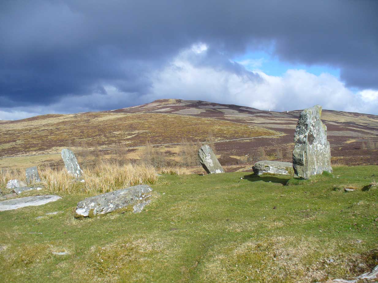
This is quite a spectacular site! Not for the size of the stones or the arrangement of the megaliths, but for the setting! It’s outstanding! When a bunch of us wandered up here a few months ago, snow was still on the peaks and Nature was giving us a real mix of Her colours and breath in a very changeable part of Her season. Twas gorgeous. Perhaps the setting was the thing which has kept the circle pretty quiet until recent years. It’s high up – and out of season the freezing winds and driving rains would keep all but the healthiest of crazy-folk away. We all only wished we’d have had more time here. But that aside…
Lara between the old stonesJ.D. MacLeod’s 1909 groundplan
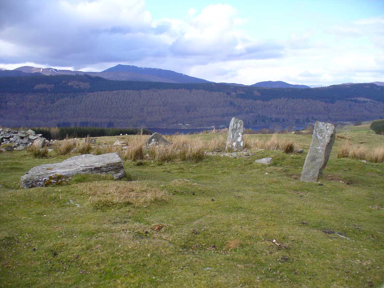
Along with the changeable weather She gives up here, the literary-types have given this circle changeable names too. Nowadays known as the Acharn Falls stone circle, in truth that’s a mile away and lacks in both visual and geographical accuracy. ‘Greenland’ was the name cited when J.B. MacKenzie (1909) wrote about it more than a hundred years back, and it’s the name we find in Mr Burl’s (2000) magnum opus, despite him telling how “a local name for it is Auchliacha, ‘the field of stones'” (Burl 1995), so perhaps we should adhere to what the locals say (my preference generally).
The atmospheric ring, looking WGreenland Circle, looking N
The ring is in quite a mess, having had a drystone wall built through it in the last 100 years. No walling is shown on the early Ordnance Survey maps, so some local land-owners (an english incomer?) was probably responsible. The stones used to stand in parts of the ancient forest, which must have looked and felt quite something before they ripped the trees away. It was hiding away in the woods when J.B. MacKenzie (1909) came here, shortly after the “modern wall” as he called it, had been constructed through the circle. He wrote:
“Six stones remain on the site, of which four are still erect and in position, and two are prostrate, one of which has apparently fallen inwards and the other outwards of the line of the circle, the diameter of which, touching the inner sides of the stones still standing, is 27 feet 9 inches. Mr MacLeod has supplied the following dimensions of the several stones:
A — 6 feet 9 inches x 3 feet 6 inches, lying flat
B — 8 feet 4 inches, in circumference at ground level
——1 foot 7 inches, high above the ground level
C — 6 feet 10 inches, in circumference at ground level
——4 feet 0 inches, high above ground level
D — 6 feet 0 inches, in circumference at ground level
——4 feet 3 inches, high above ground level
E — 7 feet 8 inches x 4 feet 6 inches, lying flat
F — 9 feet 0 inches, in circumference at ground level
——5 feet 8 inches, high above ground level.”
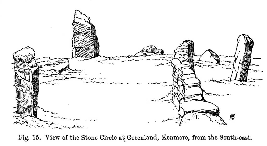
Coles’ 1910 sketch of the siteColes’ 1910 ground-plan
The year after MacKenzie’s notes, the great Fred Coles (1910) paid a visit here. Noting how high it was in the landscape compared to other megalithic rings in the region (it’s the highest known circle, at 1240 feet up), he went on to give his usual detailed appraisal, telling:
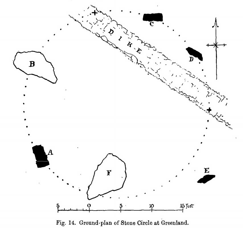
“In a little clearing amid these woods on Craggan Odhar, but disfigured by a dike which separates some of the Stones from the others, stands this Greenland Circle of which the ground-plan is given…. The Stones are six in number, of which four are erect, and they all appear to be of the quartzitic schist. Some disturbance has occurred, and it seems probable that there were at least two more Stones originally, one between B and C at the spot marked with a cross, and the other similarly marked midway between D and E. There is, however, no vestige of any Standing Stone in the sides of the dike itself.
“On the south-west is Stone A, the tallest, with pointed top, 5 feet 7 inches in height, oblong in contour, and measuring at the base 9 feet 5 inches. Having several deep horizontal fissures, this Stone…bears an odd resemblance to masonry. The next Stone, B, lies prostrate, measuring 7 feet 9 inches by 4 feet, and about 1 foot in thickness above ground. The little oblong Stone, C, on the other side of the dike, stands only 1 foot 10 inches above ground, and probably is a mere fragment—the stump of a much larger block. At D the Stone is 4 feet 3 inches in height, and is a very narrow slab-like piece; Stone E, which has a decided lean over towards the interior of the Circle, is 4 feet 2 inches high, and is in basal girth 6 feet 6 inches. Like the others, it is angular and thinnish in proportion to its breadth. Stone F measures 8 feet 2 inches by 5 feet 2 inches, and its position, with the narrow end resting almost on the circumference, suggests, as in other cases, the probability that it was this narrow end which was buried when the Stone was erected. These blocks were most likely brought from the low cliffy ledges near, for, as the name ‘Craggan Odhar’ implies, the place was, before being planted, conspicuous for its Grey Crags.”
Although no modern excavation has taken place, when the brilliant local historian William Gillies (1925) first got round to exploring the circle, he remedied that situation. In probing the ground beneath the surface when the weather conditions allowed, Mr Gillies found that there seemed to have been more standing stones in the circle than presently meets the eye. He wrote:
“I paid several visits last summer to this lonely and elevated spot, and examined the ground for stones, where the wide spaces between those indicated on the plan (see Coles’ 1910 drawing, above) suggested that others might be concealed beneath the turf. There would appear to be three stones missing, which would make the circle to consist of nine in all when it was entire. With little trouble, at a depth of only 3 inches, I located a large flat stone measuring 5 feet 6 inches by 4 feet 8 inches. It had stood on the north-western arc of the circle half-way between the fallen stone on the west and the broken standing stone on the north-north-west. It had fallen outwards. The foundation of the wall, built probably some seventy years ago to enclose the plantation, rested on the edge of the stone. The ground along the circumference of the circle between the three stones on the eastern side was carefully probed, but the rod touched only small loose stones.
“I next turned up the centre of the circle, and at a depth of 5 inches below the surface came upon a dark deposit. It extended over a space of 2 feet square and was about 5 inches in depth. It was mixed with a white limy substance consisting of calcined bones, bits of which along with a sample of the dark substance I brought to the Museum. A bit of charcoal from the deposit revealed the lines of cleavage in the wood. There is no peat at the spot, although the elevation, which is at least 1200 feet, might suggest it. The surrounding soil is of a reddish colour, and quite unlike the deposit which must have been placed there, and which was probably a burial after cremation.”
Greenland circle, looking NE
Gillies was exemplary in his exploration of sites that were on the verge of disappearing from tongue and text and we remain incredibly grateful for his later exposition on the antiquarian remains and legends of this truly stunning landscape. In Aubrey Burl’s (1995; 2000) respective summaries of this stone circle, as well as that of John Barnatt (1989), they ascribe the situation of it originally having 9 stones, as Gillies suggested.
Visit this site! If you’re into megaliths, you’ll bloody love it!
References:
Barnatt, John, Stone Circles of Britain – volume 2, BAR: Oxford 1989.
Burl, Aubrey, A Guide to the Stone Circles of Britain, Ireland and Brittany, Yale University Press 1995.
Burl, Aubrey, The Stone Circles of Britain, Ireland and Brittany, Yale University Press 2000.
Money, Bob, Scottish Rambles – Corners of Perthshire, Perth 1990.
Acknowledgements: Many thanks to the unholy bunch who helped travel, locate, photograph and take notes on the day of our visit here, including Aisha, Lara & Leo Domleo; Lisa & Fraser; Nina and Paul. Let’s do it again and check out the unrecorded stuff up there next time!
There are two ways into this glen by road. Whichever route you take (from Crieff side, or via the long Dunkeld route), when you hit the flat bottom of it, where the green fields are right by the roadside, walk along till you find the road meets the river’s edge. On the south-side of this small roadside section of the river, you’ll see a single large boulder 10-20 yards away. That’s the spot!
Archaeology & History
Described in some of the archaeology texts as just a ‘cist’, this giant stone is obviously the remains of much more. For a start, as the 1834 drawing illustrates here (coupled with several other early descriptions of the place), other visible antiquarian remains were very much apparent at Ossian’s Stone before a destructive 18th century road-laying operation tore up much of this ancient site. A marauding General Wade of the English establishment was cutting through the Scottish landscape a “military road”, to enable the English to do the usual “civilize the savages”, as they liked to put it. This curious “Giant’s Grave” was very lucky to survive.
Skene’s 1834 sketch, showing surrounding ringOssian’s Stone in the Sma’ Glen
The earliest description of events surrounding the site, as well as the attitude of the Highlanders when they saw the disrespectful English impose their usual disregard, is most insightful. In a series of letters written by a Captain Edward Burt (1759) in the first-half of the 18th century to the english monarch of the period, we read a quite fascinating account which must have been very intriguing to witness first-hand.
General Wade and his band of marauders had reached the Sma’ Glen at the end of Glen Almond and were about to continue the construction of their road. Burt (1759) wrote:
“A small part of the way through this glen having been marked out by two rows of camp colours, placed at a good distance one from another, whereby to describe the line of the intended breadth and regularity of the road by the eye, there happened to lie directly in the way an exceedingly large stone; and, as it had been made a rule from the beginning, to carry on the roads in straight lines as far as the way would permit, not only to give them a better air, but to shorten the passenger’s journey, it was resolved the stone should be removed, if possible, though otherwise the work might have been carried along on either side of it.
“The soldiers, by vast labour, with their levers and jacks, or hand-screws, tumbled it over and over till they got it quite out of the way, although it was of such an enormous size that it might be matter of great wonder how it could ever be removed by human strength and art, especially to such who had never seen an operation of that kind: and, upon their digging a little way into that part of the ground where the centre of the base had stood, there was found a small cavity, about two feet square, which was guarded from the outward earth at the bottom, top, and sides, by square flat stones.
“This hollow contained some ashes, scraps of bones, and half-burnt ends of stalks of heath; which last we concluded to be a small remnant of a funeral pile. Upon the whole, I think there is no room to doubt but it was the urn of some considerable Roman officer, and the best of the kind that could be provided in their military circumstances; and that it was so seems plainly to appear from its vicinity to the Roman camp, the engines that must have been employed to remove that vast piece of a rock, and the unlikeliness it should, or could, have ever been done by the natives of the country. But certainly the design was, to preserve those remains from the injuries of rains and melting snows, and to prevent their being profaned by the sacrilegious hands of those they call Barbarians, for that reproachful name, you know, they gave to the people of almost all nations but their own.
“…As I returned the same way from the Lowlands, I found the officer, with his party of working soldiers, not far from the stone, and asked him what was become of the urn? To this he answered, that he had intended to preserve it in the condition I left it, till the commander-in-chief had seen it, as a curiosity, but that it was not in his power so to do; for soon after the discovery was known to the Highlanders, they assembled from distant parts, and having formed themselves into a body, they carefully gathered up the relics, and marched with them, in solemn procession, to a new place of burial, and there discharged their fire-arms over the grave, as supposing the deceased had been a military officer.
“You will believe the recital of all this ceremony led me to ask the reason of such homage done to the ashes of a person supposed to have been dead almost two thousand years. It did so; and the officer, who was himself a native of the Hills, told me that they (the Highlanders) firmly believe that if a dead body should be known to lie above ground, or be disinterred by malice, or the accidents of torrents of water, &c. and care was not immediately taken to perform to it the proper rites, then there would arise such storms and tempests as would destroy their corn, blow away their huts, and all sorts of other mis-fortunes would follow till that duty was performed. You may here recollect what I told you so long ago, of the great regard the Highlanders have for the remains of their dead…”
Ossian’s Stone in his landscape
We can rest assured that the ‘Roman officer’ idea proclaimed by our early narrator is most probably wrong and that the nature of this site, when seen at ground-level even today and moreso by referencing Skene’s 1834 drawing of the place, above (which shows a more complete low surrounding ring of stones) indicate this to be of prehistoric provenance. Of intrigue to me, is the ritual of the incoming Highlanders, who took the relics onto another place and re-interred them in their own customary manner. We do not know where the Highlanders moved these (probable) prehistoric relics and I can find no supporting folklore to show precisely where they went—but a likely site would be the prehistoric cairn on the mountaintop southwest of here (at NN 8899 3018), or a site that has sometimes been confused with Ossian’s Stone a short distance to the south in the Sma’ Glen, known as the Giant’s Grave (at NN 9050 2956). This latter site would seem more probable.
Anyway…. many years after Edward Burt’s initial Letters defined the site for outsiders, one Thomas Newte (1791) came a-wandering hereby. He found that the account of General Wade’s intrusion was still on the tongues of local people, along with additions of further giant-lore and Fingalian tales, typical of the Creation myths of our early ancestors. In typically depreciative English manner Newte told:
“In that awful part of Glen Almon, already mentioned, where lofty and impending cliffs on either hand make a solemn and almost perpetual gloom, is found Clachan-Of-Fian, or monumental Stone of Ossian. It is of uncommon size, measuring seven feet and an half in length, and five feet in breadth. About fifty years ago, certain soldiers, employed under General Wade in making the Military Road from Stirling to Inverness, through the Highlands, raised the stone by large engines, and discovered under it a coffin full of burntbones. This coffin consisted of four gray stones, which still remain, such as are mentioned in Ossian’s Poems. Ossian’s Stone, with the four gray stones in which his bones are said to have been deposited, are surrounded by a circular dyke, two hundred feet in circumference, and three feet in height. The Military Road passes through its centre.”
Cole’s 1911 plan of stone & surrounding ringOssian Stone by Fred Cole
From hereon, many other writers and travellers came to see this great legendary stone within the depleted remains of its embanked circle—and thankfully it hasn’t been disturbed any further, still being visible to this day. The greatest ‘archaeological’ attention the site has received was from the early pen of great antiquarian Fred Coles (1911). On his journey here, after travelling past a large white stone which was mistakenly named as Ossian’s Stone by the usual contenders, he and his friend reached the right place:
“close to a strip of ground where the river and road almost touch each other, and immediately below the steepest of the crags of Dun More on the eastern side and the debris slopes of Meall Tarsuinn on the west, a most impressive environment, be the stone a prehistoric monument or not! The spot is interesting for itself, apart from all legend; and the remains consist of a mighty monolith…and a narrow grassy mound…to its east, with a few earthfast blocks set edgewise near its eastern extremity. Close to the roadside, but at the same level of 690 feet above the sea, there is a slab-like stone set up, measuring 3 feet in width, 1 foot 3 inches in thickness, and about 2 feet 6 inches in height. A space of 63 feet separates this block…from the huge rhomboidal mass called Ossian’s Stone. Five feet east of the latter is the base of the grassy mound which measures about 12 feet in length, 4 feet in greatest breadth, and 3 feet 10 inches in height. To the north and the south in a slightly curving line are set the six small slabs shown. There seems also to be a vague continuation of this strange alignment in both directions. All over the ground between A and B, are many strangle low parallel ridges of smallish stones having a general direction of nearly north and south. The rest of the ground is grassy, and here and there a little stony. In the plan all the stones are drawn larger than exactly to scale.
“The great stone is 8 feet high and has a basal girth of 27 feet. Several small stones lie near it. Such are the facts as at present to be observed on the ground.”
Section of outlying grass-covered low ring, just visibleGeological cup-marks?
There are two small conjoined cup-marks on top of the stone, but these seem to be geological in nature. The precise nature of the site is difficult to ascertain without excavation; but the Royal Commission lads reckon it to be a prehistoric ‘cist’ or grave in their own analysis, based mainly on the quoted literary texts. The surrounding ‘ring’ of small stones doesn’t seem to have captured their attention too much; but the site needs contextualizing within this damaged circular enclosure, which appears to have been a cairn circle initially, of some sort, with Ossian’s huge stone resting over the grave of one late great ancestral character, probably placed here thousands of years back in the Bronze Age… A truly fascinating place in truly gorgeous landscape.
Folklore
The glen itself has a scattering of giant lore associated with Finn and/or Ossian. A nearby cave was one of the places where this legendary character, and subsequent bards, were said to have spent time.
There are a small number of heavy rocks presently placed on top of Ossian’s Stone. These may be due to the site being used as a “lifting stone”: a sort of rite of passage found at a number of sites in the Perthshire mountains and across the Highlands to indicate a boy’s strength before entering manhood. Not until they have lifted and deposited a very heavy rock onto the boulder can they rightly become chief or leader, etc.
The poet William Wordsworth wrote about Ossian’s Stone, calling it “Glen Almein, or The Narrow Glen”:
In this still place, remote from men,
Sleeps Ossian, in the Narrow Glen;
In this still place, where murmurs on
But one meek streamlet, only one:
He sang of battles, and the breath
Of stormy war, and violent death;
And should, methinks, when all was past,
Have rightfully been laid at last
Where rocks were rudely heaped, and rent
As by a spirit turbulent;
Where sights were rough, and sounds were wild,
And everything unreconciled;
In some complaining, dim retreat,
For fear and melancholy meet;
But this is calm; there cannot be
A more entire tranquillity.
Does then the Bard sleep here indeed?
Or is it but a groundless creed?
What matters it? I blame them not
Whose Fancy in this lonely Spot
Was moved; and in such way expressed
Their notion of its perfect rest.
A convent, even a hermit’s cell,
Would break the silence of this Dell:
It is not quiet, is not ease;
But something deeper far than these:
The separation that is here
Is of the grave; and of austere
Yet happy feelings of the dead:
And, therefore, was it rightly said
That Ossian, last of all his race!
Lies buried in this lonely place.
References:
Anonymous, Tourists Guide to Crieff, Comrie and the Vale of Strathearn, Crieff
1874.
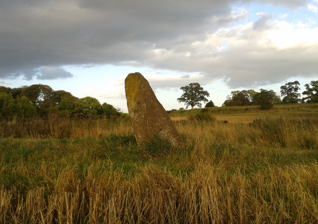
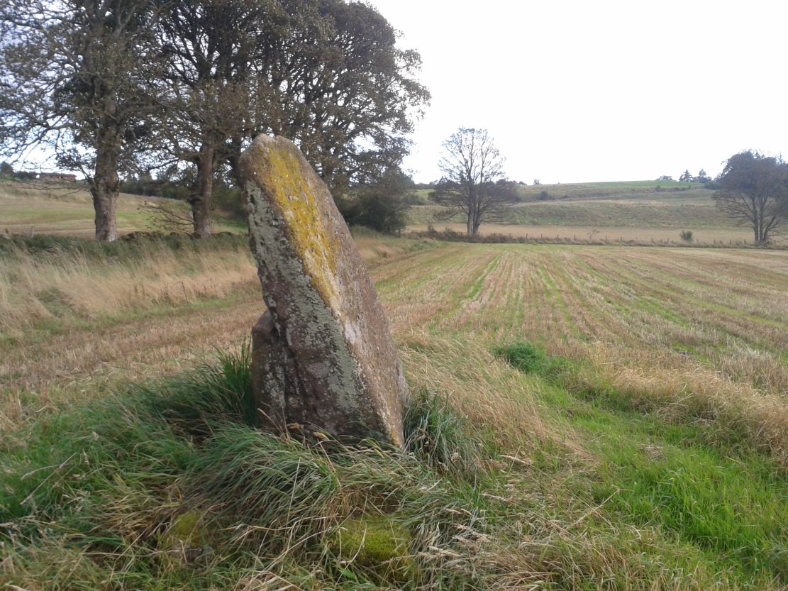
Take the A822 road south out of Crieff and less than half a mile down, in a field on the east side of the road is the giant solitary standing stone of Dargill. On the opposite side of the road from here (roughly) is a small country lane. Go along here and past the third field on your left, park up. Look down the fields for a coupla hundred yards and you’ll see the standing stone. Make your way there by following the field-edges.
Archaeology & History
Concraig stone, near Crieff
Closer to the larger town of Crieff than it is to the village of Muthill, this seven-foot tall standing stone, leaning at an angle to the north and with a small scatter of stones around its base, stands alone near the side of the field, feeling as if others once lived close by. It’s set within a distinctly nurturing landscape, enclosed all round instead of shouting out to the hills, with that nourishing female quality, less commonly found than those stones on the high open moors. The only real ‘opening’ into a wider landscape here was mentioned by the local writer Andrew Finlayson (2010), “to the distant east.” Whether this possessed any astronomical-calendrical importance hasn’t yet been explored.
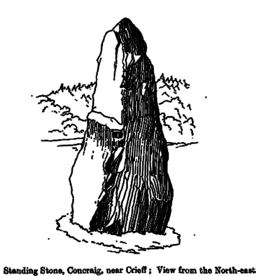
Concraig, looking southFred Coles 1911 sketch
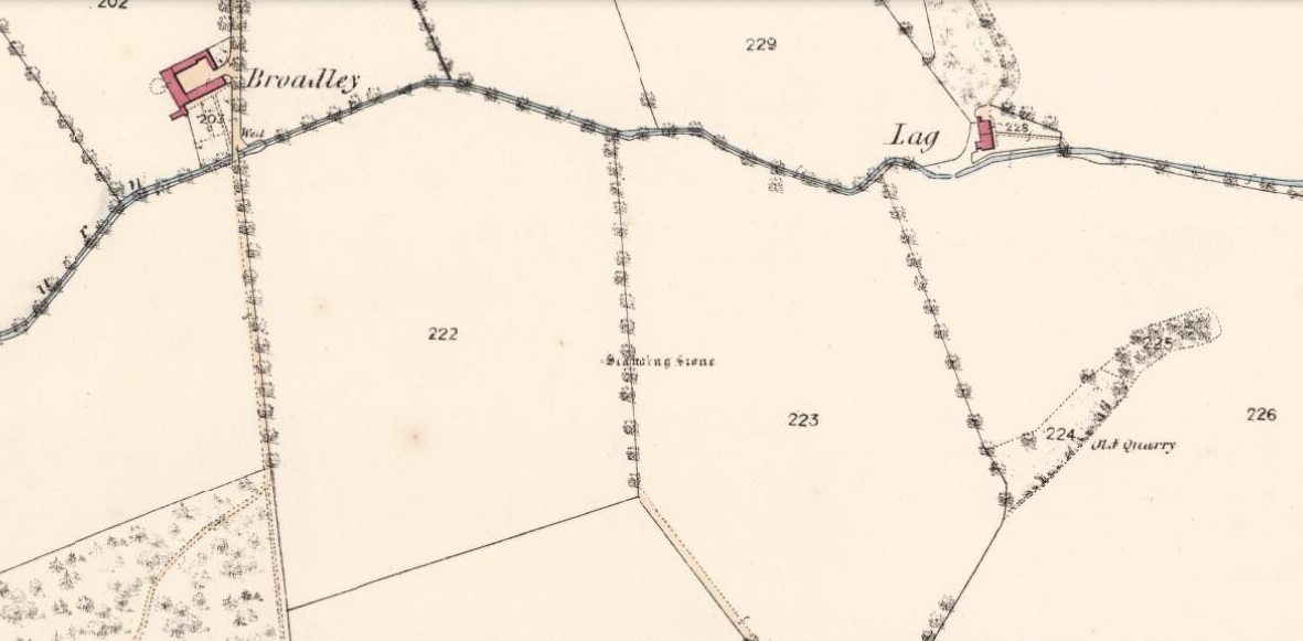
The stone was first highlighted on the 1863 Ordnance Survey map—and described in their Name Book as “a large upright Stone adjacent to and South-east of Broadley about 8 feet high and traditionally said to be either the remains of a Druidical Temple or in some way associated with the Druidical period”—but since then it hasn’t fared very well in antiquarian tomes. Fred Coles (1911), as usual, noted it in one of his Perthshire surveys, but could find very little information from local people about the place, simply telling us that,
“in an open field about 300 yards to the north-west of Concraig, there stands this irregularly four-sided block of conglomerate schist… The stone measures 9 feet 3 inches round the base and stands 7 feet 3 inches in height. About halfway up its eastern face it has been broken so as to leave a very distinct ledge.”
What appears to be cup-markings on the southern-face of the stone are just Nature’s handiwork.
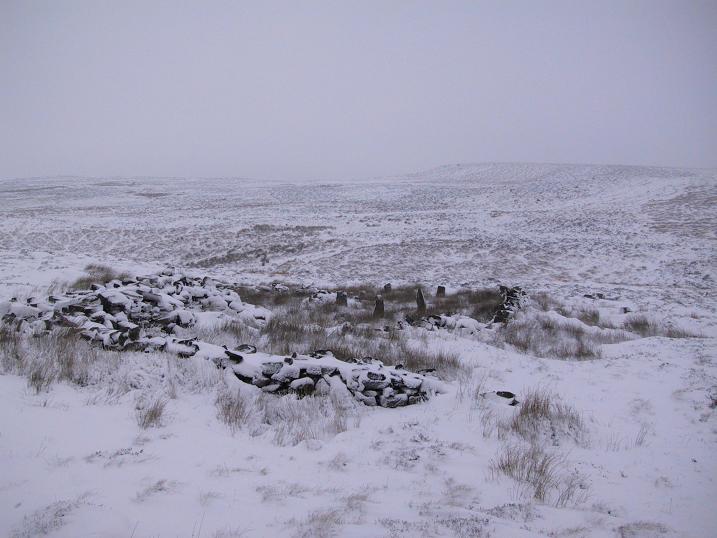
The ruins of Backstone Circle (photo, Richard Stroud)
There are many routes to get here, but this is the one I usually take. From Cow & Calf Rocks, walk up the steep hillside onto the first moorland plain, taking the path right, diagonally, across to the NW as if you’re heading to the Map Stone. From here, looking down at the stream valley below, follow the valley edge up, past the settlement, and then veer down to Backstone Beck and up on the other side till you meet with a footpath and also up in the heather ahead of you, notice the jumbled walling less than 100 yards away. That’s where you need to be!
Archaeology & History
A singular short sentence in Robert Collyer and J.H. Turner’s Ilkley, Ancient and Modern (1885) started it all off, where they told:
“There was still a rude circle of rocks on the reach beyond White Wells fifty years ago, tumbled into such confusion that you had to look once, and again, before you saw what lay under your eyes.”
…..And thankfully this is still what we see today – and in just the area they mentioned.
I’m intrigued to find there’s so much said about this site on the Net and feel I should put my recent feelings about the place to print at last (and after being badgered to gerrit done by James Elkington!). The information about its make-up and the mess it’s in, hasn’t changed since we rediscovered the place on June 3, 1989. Here, amidst the tall grasses and reeds of Juncus effusus and J. conglomeratus, our jumble of megaliths hides within a breakdown of fallen walls, that are thought to have been part of some sheep-fold or a similar animal enclosure (mebbe for the annual sheep-shagging contests that are held, quietly, on these moors each year!).
The name ‘backstone’ itself come from the adjacent beck (slowly depleting as the years pulse by) and is mentioned in the 18th century parish registers. A.H. Smith (1961) informs us that it was the “stream where bakestones were got”, and this was probably a tradition going way way back. The baking stones from the beck may even have been used by the people living in the prehistoric settlements close to the circle.
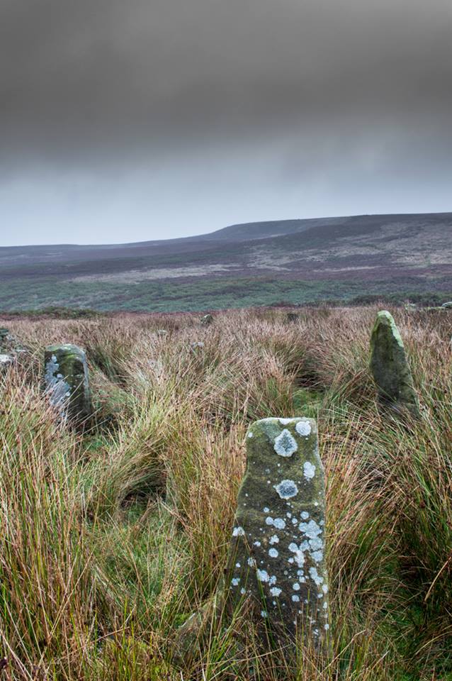
Stones amidst the reeds
In what looks today like a messy double-ring of stones, it’s likely there was originally just a single ring which has, subsequently, been knocked down and re-used for some form of sheep-fondling sessions—be it agricultural or otherwise! But for the record at least: we have small inner ‘ring’ of four upright stones, re-worked in more recent centuries, between two-and-a-half to three-and-a-half feet tall. Another stone is recumbent. The outer ring is more conspicuous. It consists of at least eight standing stones–seven of which are upright–between three and five feet tall, some of which have been re-worked in more recent times. There are several other stones either recumbent or partly covered by vegetation. The tallest of the stones is 4’11” tall. The outer circle has had at least one of the stones uprooted and used at the base of the dry-stone walling intruding the southwest side of the circle. What appears to be at least two original standing stones are embedded into earthworks on the other side of this wall, one of which was located through dowsing!
The best section of the ring can be seen on its eastern side, where an arc of upright stones between three and four feet high are still clearly in evidence, just inside a raised embankment like that found surrounding the Twelve Apostles stone circle less than a mile away.
A short while after finding the site, we contacted the Ilkley Head of Archaeology Studies, Gavin Edwards, about the circle and he subsequently included the site on one of the tourist-guides to the moors.
Alignments through this circle seem apparent in situ; and although such alignments are intriguing (to me anyhow), it’s the geometric relationship Backstone has with other circles on these moors that is rather notable. It’s position in the landscape plays an essential part in an isosceles triangle formation, 1180 yards [1.08km] from the Twelve Apostles stone circle which, as the centre point, is another 1180 yards from the Roms Law Circle. Odd….
Immediately visible from our ruinous circle across the small valley to the slopes of Green Crag, the Ilkley Archaeology Group spent more than fifteen years excavating the remains of what was initially thought of as a Bronze Age village, but their work here has proved startling, pushing the date of human occupation here into the mesolithic period! Local archaeologist Gavin Edwards opined that the Backstone circle would have been the religious site for the people who lived here. I have to concur. There are also more neolithic and Bronze Age walling, indicative of extended settlements and enclosures, less than 200 yards north of the Backstone Circle, structurally consistent with the remains across the valley at the excavated Green Crag Slack settlement.
Ten yards east of the circle is a small well which only runs following exceptional rainfall. This was probably of some ritual importance to the people who practiced rites here. Geological fault lines run not far away on three sides of the ring and an underground stream is present, quite close to the surface (as indicated by the presence of Juncus conglomeratus and J.effisus), encouraging the preponderance of regular electromagnetic variations: these in particular are likely to have some causative influence on the paranormal events described below….
Fortean History
Since rediscovering this site, a number of bizarre psychophysical anomalies have been experienced and described by more and more people — some of whom were previously very sceptical of such things. Both day and night, no doubt when Moon and water speak their subtle electromagnetic accord, a gathering corpus of all-too-familiar events keep speaking of a most disturbing resident spirit…
We begin on Wednesday, July 12, 1989, sometime around midnight, when an acquaintance and I were spending a few days here to record any possible electromagnetic anomalies at this disturbed ring of stones. We weren’t to be disappointed, as something very untoward raised its peculiar head.
As I sat barely ten yards beyond the tumbled group of stones there suddenly appeared, from nowhere, a host of figures—a dozen at most—walking ever so slowly around the old site. I could discern no physical features other than their height and humanoid shape. It was just too dark to see any details about them—they were, effectively, silhouettes. My acquaintance was terrified—although it was perhaps a minute or so before he even glanced at what I was pointing and exclaiming at, somewhat manically, stuttering and shaking my head in an attempt to make the things disappear back to my unconscious where they surely originated. Didn’t work though!
These were no psychic projections. I literally shook my head, closed my eyes and knocked my head against the walling; looked away, shook my head again, shouting at myself and looked back at the figures in front of us. It still didn’t do a damn thing! By now my friend was staring, aghast and scared shitless if the expression on his face was anything to go by.
“Wot a’ y’ seeing? Wot can y’ see?” I asked.
He murmured and mumbled something about some people he could see, walking round and round the old remains.
He was seeing exactly the same as what I could see. As the minutes passed by, this group of people, who were winding in and out of each and every stone and walking through the intrusive walling as it was not there, slowly but surely, ever so gradually, increased in speed. This was very slow and patient and went on for at least fifteen minutes — by which times they were barely visible as individual figures anymore. All we could see by now was a visual blur and a remarkable vortex that was created in the wake of their ‘dance’.
This spinning vortex of silhouettes seemed to get faster and faster until appearing to reach a sort of critical speed/energy state — and as this “critical state” occurred, what was by now a rapid spinning, energetic blur simply vanished right before our eyes! It was as if someone, somewhere, had flicked a switch and they disappeared. Yet, at the very same moment the blurred vortex vanished, several dead straight lines of orange-red appeared in their place. These were as baffling as the dance we had just watched: very thin, wavering lines of what I can only describe as subtle light, bounced off several of the standing stones. These lines—perhaps four of them—did not originate from the circle but appeared to come from further afield. One in particular seemed to come from the direction of the great boulder known as the Idol Rock, 700 yards [650m] east and continued past our field of vision in the direction of the Swastika Stone.
To be honest these “lines of energy” perturbed me more than the spinning figures which had just disappeared. Not only were these lines two-dimensional [a real screw-up that one!], I was at a loss to explain what these lines really were. The first thought was, of course, leys – but my idea of leys did not, and still does not accord with what I was seeing. Eventually the lines faded back to wherever they came, leaving both of us wondering what the hell we had just experienced.
Several minutes after talking over what had just happened, I stood up and walked into the circle. At this point, please remember it was July 12 and the night was so warm that neither of us had taken sleeping bags or a tent onto the high moors with us. As I got to the circle and took my first step inside, a tremendous shiver hit right through my body, almost like I was walking into a freezer. But I moved another step forward, unperturbed if truth be had by the probable chill wind that made me shiver. As I did so, the chill became more manifest and intense. As I took my third step forward the cold became biting and I collapsed onto my knees. [This is not like me, honest. Give me camping in the Scottish mountains in mid-February with average temperatures of -6 degrees and that’s my idea of a good night out!]
Shivering like hell, I stumbled upright and back onto my feet and virtually ran out of the circle. That, more than anything else that night, truly perturbed me.
The following morning another volunteer joined us. We told him about the events of the previous night and he thought whatever he thought; but he’d brought two thermometers with him and set them on two of the rocks: one of them about 25 yards outside the circle, the other on a stone in the circle. The two of them had the same reading: 73° F. We left them without checking for a good hour or so and then began to take readings. What transpired was bizarre to say the least: the one outside the circle was 62° F, the one in the circle was 72° F. A further reading fifteen minutes later, close to sunset, showed the temperature variations had come a little closer: the inner reading was 70° F, and outer reading still 62° F. Readings were then taken every fifteen minutes and the respective readings closed in on each other until both were the same, exactly when the sun was touching the horizon to set, at 9.05pm. But this was not the end of the anomaly. While the temperature outside the circle dropped naturally with nightfall, finally resting at 57-58° F, the inner circle reading continued falling at nearly twice the background rate! Our final reading after 11pm showed a deviation of nearly 7 degrees between the respective thermometers!
If these elements seem in anyway somewhat unbelievable, what occurred next bends the parameters of reality still further!
No further anomalous Fortean events happened at the circle that night—for us at least. However, a friend in Leeds—the internationally renowned ritual magician and author, Phil Hine—was at home with some friends, chatting.
“On the night in question,” he came to write sometime later, “I was talking to another magickian. He returned from the toilet and informed me that there was an “entity” lurking in the stairwell… This was unusual, but not sufficiently unusual to cause undue concern, and so, picking up my thunderbolt, I went out to see what was what. In the stairwell we both agreed on seeing a black amorphous shape. Since my friend had first noticed this, I asked him if he would be prepared to “open his mind” to it, so that I could question it, using him as an interface [which was one of his particular talents] and a fairly accepted procedure for questioning strange entities. “The entity declared,” I have come from the ancient hills.” It also stated that it had been “awakened” only recently due to activity around a sacred site. It said that it had come to give me “power” with which I could do something, but was reticent about the exact nature of this. When I asked what it would do if I rejected this, it said that it would return “screaming to the hills.” When I asked it to identify itself it gave the name Azathoth—which could well have sprung from the mind of my friend, although he had no particular knowledge of the Cthulu mythos entities.”
Phil continued:
“At the time I found it difficult to credit that such a powerful entity would be hanging politely about in the stairwell waiting to be noticed. Being unable to obtain a direct answer to my questions, I told it to go forth, which it apparently did. I later had to perform an intense banishing ritual on my friend who was suffering from symptoms such as feeling cold, a tight pressure on the chest, personality displacement, and motor spasms… Unbeknownst to me at the time, two friends of mine who were members of the West Yorkshire Earth Mysteries Group had experienced a strange encounter at the then newly-uncovered Backstone Circle on Ilkley Moor… It seems strange, on reflection, that the appearance of the entity claiming to originate from a newly disturbed site seems to relate to their experience.” [Hine 1994, 1997]
Other bizarre experiences at the circle itself have been reported by growing numbers of people—a lot of them quite unpleasant. One lady, Katy from Calderdale, whose interest in megaliths rarely stretched into the obscurities of their folklore or weird tales, will “probably never go there again. It terrified me. I don’t know why, there was nothing to be scared of, but the place just felt awful.”
There have been at least a dozen people who have related the same words to me—and I can empathise. On February 14, 1990, Mick N. and I went to the site for the night with intent to do a bit of sympathetic ritual magick. The night was cold and a slight fall of snow glittered across the moors as far as we could see, invoking quite healthy feelings about the forthcoming rite. But as we turned off the path and approached the stones, it was as if we had walked through an invisible gate or door just yards before the circle itself, screaming quite powerfully with gnarled teeth that we were not wanted there that night! It was overwhelming! We both acted accordingly and spent the night elsewhere, cold and querying over its genius loci. The potency of Azathoth seemed inherent in its silent voice.
This particular feeling, almost of malevolance, has been described by many people at Backstone. It occurs both day and night and is akin to what Prof Thomas Lethbridge (1961) described as ‘ghouls’: place-memories so to speak, or spirits of place. Most of the time there is no such feeling, of course. But when conditions are right, these potent subjective consumations can be quite overwhelming at some spots. They are reported worldwide in the aboriginal traditions of all races and are felt, obviously, even today by explorers, mountaineers and visitors to ancient haunted places like the Backstone Circle.
Strange lights have also been seen over and around here by a number of witnesses. On one occasion a ritual invocation of its spirit-nature brought forth a number of glowing red spheres of light. These were about the size of footballs, appearing for a minute or two, floating in front and around us, then vanishing—only to reappear yards away around the edges of the damaged ring of stones. These were very obviously living things and were examining us with equal bewilderment. Other light-phenomena that people have seen here and on this moor appear to relate to the phases of the Moon.
Although the site is quite ruinous, it is a worthwhile place to visit – just respect, and beware the Old Hag who sometimes comes forth from time to time….
References:
Bennett, Paul., “The Backstone Circle,” Earth 15, 1990.
Bennett, Paul, “Archaeological and Geometrical Applications of the Lost Stone Circle of Ilkley Moor,” Earth 15, 1990.
Bennett, Paul, Circles, Standing Stones and Legendary Rocks of West Yorkshire, Heart of Albion Press: Wymeswold 1994.
Bennett, Paul, “The Strange Case of Backstone Circle,” Right Times 1, 1998.
Bennett, Paul, The Old Stones of Elmet, Capall Bann: Milverton 2001.
Collyer, Robert & Turner, J. Horsfall, Ilkley: Ancient and Modern, William Walker: Otley 1885.
Devereux, Paul, Places of Power, Blandford: London 1990.
Gyrus T., “An Interview with Phil Hine,” Towards 2012 volume 4, 1998.
Hine, Phil, “The Physics of Evocation,” Chaos International 1990.
Roberts, Andy, Ghosts and Legends of Yorkshire, Jarrold: Norwich 1997.
Smith, A.H., The Place-Names of the West Riding of Yorkshire – volume 4, Cambridge University Press 1961.
Acknowledgements: Many thanks to Richard Stroud for his photo of Backstone at winter time; to James Elkington for saying, “Come on Paul – get yer finger out!” + his photos too…
Take the same directions as if you’re visiting any of the upper Ballochraggan petroglyphs, but 100 yards before the carvings, out in the open on the grasslands, below the reach of the forest, you’ll see the leaning stone if you wander about. You can’t really miss it!
Archaeology & History
Not included in any of the Canmore, Royal Commission or Ordnance Survey records, this standing stone appears to have eluded official records until now. Found close to the petroglyph-rich arena of the Ballochraggan complex, with attendant tombs to the east, there is the possibility that this large leaning stone was itself, once, a part of a long-gone cairn, as Paul Hornby suggested. The small cluster of stones around its base certainly adds to that idea (similar to the incredible Dunruchan cluster, more than 17 miles (28km) northeast).
The stone leans at a considerable angle from a previously upright position. When standing it would have been nearly five-feet tall and measures nearly as wide. The stone is roughly triangular in shape, above ground. What appear to be two faint cup marks on its topmost surface are very probably due to conglomerate rock erosion and not the handiwork of humans.