From the old cross in the middle of the village, walk along the A820 Balkerach Street main road (NOT down George Street) until you reach Station Wynd on your right. Walk up here for 100 yards towards the new housing estate (don’t buy these places – they’re dreadful quality beneath the veneers) and there, on a small grassy rise on the left just before the car park, stands our stone!
Archaeology & History
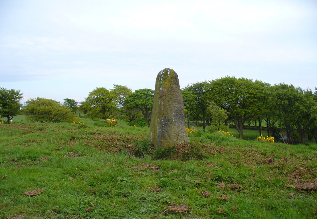
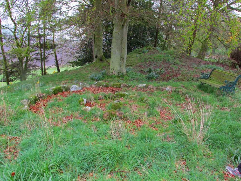
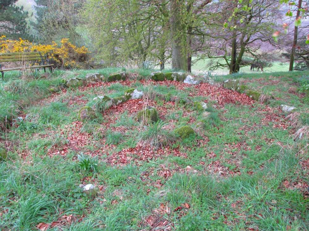
This little-known monolith on the northern edge of little Doune village, was recently moved a short distance from its original position thanks to another one of those sad Barratt housing estates being built here; but at least it has received protection with the surrounding fence and notice board telling its brief history and folklore (better than being destroyed I s’ppose).
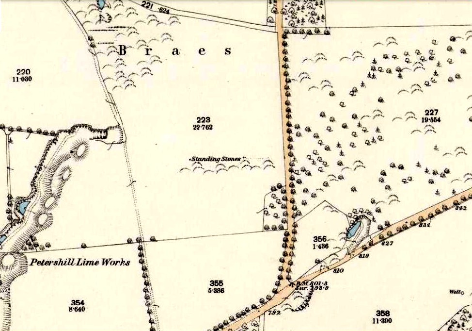
Stone on 1866 OS map
Standing less than five feet tall, local lore tells that it has been moved around close to this spot several times in the last couple of centuries. Although not mentioned in Hutchinson’s (1893) essay on local megaliths, the stone was highlighted on the 1866 Ordnance Survey of Doune, where the non-antiquated lettering showed how it was thought to be Roman in origin, not prehistoric.
Folklore
Trysting Stane, looking NE
The name of the stone comes from it being used as a place where deeds were sworn, with the stone as witness to the words proclaimed by both parties (implying a living presence, or animistic formula of great age). This activity was continued in the local ‘trysts’ or cattle fairs held a mile away, where buyers swore the sale of cattle at this stone—again with the stone being ‘witness’ to the spoken deals. It was also used as a counter where gold was exchanged for cattle bought and sold during the Michaelmas and Martinmas Fairs. Sue Harvey (2006) told that this standing stone,
“was called the Devil’s Head and was used during past Doune fairs to count gold on when cattle were being bought and sold.”
In local newspaper accounts from the 1950s, local historian Moray S. Mackay (1984) told how the children of the village used to gather round the stone, holding hands, and sing,
Olie Olie, peep, peep, peep,
Here’s the man with the cloven feet,
Here’s his head, but where’s his feet?
Olie Olie, peep, peep, peep.
Notice board telling its tale…Looking at the stone on its rise
This implies the stone once possessed a myth relating to a petrified ancestral deity of animistic (pre-christian) origin, but as yet we have found no additional information allowing us a confirmation of this probability. A correlate of this theme—i.e., of the stone being the head of a deity—is found in West Yorkshire (amongst many other places), where one of the little known Cuckoo Stones was once known to be a local giant until a hero-figure appeared and cut off his head, leaving only his body which was then turned to stone. Mircea Eliade (1958; 1963) cites examples of animistic religious rites and events explaining this early petrification formula via creation myths, etc. (we find very clear evidences of animistic worldviews and practices still prevailing in the mountains just a few miles north and west, still enacted by local people)
Folklore also alleged that the stone was Roman in nature, but neither archaeology nor the architectural form of the stone implies this. Roman stones were cut and dressed—unlike the traditional looking Bronze Age, rough, uncut fella standing here.
References:
Eliade, Mircea, Patterns in Comparative Religion, Sheed & Ward: London 1958.
Eliade, Mircea, Myth and Reality, Harper & Row: San Francisco 1963.
Harvey, Sue, Doune and Deanston, Kilmadock Development Centre 2006.
Hutchinson, A.F., “The Standing Stones of Stirling District,” in The Stirling Antiquary, volume 1, 1893.
Along the B880 glen road that cuts Arran roughly in half, known as The String, could once be seen a stone circle that one early writer told was quite impressive. Today It seems that all trace of the circle has gone. The earliest mention of it seems to be in James Headrick’s (1807) work, where, in discussing what he thought were “Druidical” remains of obelisks and cairns in the area,
“A more entire circle of this sort is seen on the rising ground at the mouth of Glen Shirreg, towards the west.”
But he tells us no more. Shortly afterwards—according to reverend Allan McNaughton in the New Statistical Account of the 1830s—it was destroyed. He said that,
“about twenty-four years ago, a very complete circle at the mouth of Glensheraig was removed, in clearing the field in which it stood for the operations of the plough.”
Despite this short remark, eighty years later we had J.A. Balfour (1910) inform us that,
“On the right of the String Road going west in Glen Sherraig is a small ruined monument of which three small standing stones alone remain, so disposed as to suggest that the original structure was a double circle.”
However, Balfour’s site may be an altogether different one to that mentioned by Headrick and McNaughton.
Aubrey Burl (2000) lists it in his major work; but its ancient life was, once again, brought to end in these recent years by those of less sound minds than our ancestors.
References:
Balfour, J.A., The Book of Arran – volume 1, Arran Society of Glasgow 1910.
Burl, Aubrey, The Stone Circles of Britain, Ireland and Brittany, Yale University Press 2000.
Headrick, James, View of the Mineralogy, Agriculture, Manufactures and Fisheries of the Islland of Arran, with Notices of Antiquities, D. Willison: Edinburgh 1807.
The stone circle of Fingal’s Cauldron Seat, Machrie Moor, Arran (photo by Aisha Domleo)
By whichever way you come (be it from Brodick on the east, Lochranza to the north) ask any local the way to Machrie and they’ll point you the road onto the west side of the island, roughly halfway. You’re after the hamlets of Blackwaterfoot or Auchagallon. From either of these spots, take the road to Tormore. From here, the dirt-track east close to the Machrie Water is where you need to walk. About a mile along this well-defined track you’ll see the large barn ahead of you. Hereabouts you’ll begin to notice some very tall standing stones. Keep walking on the track, and the first double-ring of smaller stones to your right is the place yer after!
Archaeology & History
Approaching the ring (photo by Aisha Domleo)
This is one well-preserved stone circle in a superb setting with other large megalithic rings all close by—at least 12 of them!—set upon the flat open moorlands on the west side of Arran, with views in all directions sending the enquiring nose tasting for more wherever the eyes gaze…. It has been written about by many many writers over the last few centuries—which aint surprising! But it was in recent times that the place was said by Aubrey Burl (1981) to be “holy ground,” because although there are many prehistoric settlement sites and other remains scattered across this landscape,
“it is noticeable that the dozens of huts whose ruins litter the moor were built well away to the west, none of them near these powerful and lonely stones.”
1832 sketch of Fingal’s Cauldron by James Skene
It’s a fair point.
Fingal’s Cauldron was first defined in an archaeological context by James Bryce in 1863, who named it the ‘Machrie Moor 5’ stone circle (MM5)—and it was he and several others who dug into the ring, to see what it might be hiding!
“Excavating at the centre we found a small cist at less than a foot in depth, and lying about north-east. It was covered by a small lid, and the dimensions were 2 feet 2 inches in length, 10½ inches in depth, and 11 inches in width. Inside there were several bone fragments and black earth. A flint implement was found in the stony soil above, and three other flint fragments, but nothing of this kind in the cist itself. This was of much ruder structure than any we had seen before (Ed. – i.e., in the other Machrie circles); it was cut out of the sold sandstone rock, but with little care or exactness; the sides however, were nearly perpendicular. The difficulty of excavating without iron tools may account for the smaller size and ruder form of this cist. No other cist was found, nor remains of any kind, though a trial was made at several points around the centre. A deep opening was also made on both sides of the upright stone, but nothing was met with worthy of being recorded.”
A.E. Roy’s 1967 site-plan
Described thereafter a number of times by different historians and antiquarians, Fingal’s Cauldron (and its associates) was then recounted in the Machrie Moor survey of Mr Balfour (1910) in his magnum opus on the Isle of Arran. Although he gave more attention to the other stone circles in this multiple megalithic complex, he did thankfully make note that,
“upon higher ground free of peat, and immediately to the south of the farmhouse, is the celebrated double circle of granite blocks known popularly as Fingal’s Cauldron Seat. The inner ring consists of eight and the outer of fourteen blocks. The diameter of the inner circle is 36 feet and of the outer 57 feet. The largest stones are in the inner series; they are more or less round-topped blocks, about 4 feet high. One of the stones of the outer ring has a ledge which is perforated by a round hole, with the edges worn smooth.
“In the centre of the inner ring, only a foot from the surface, a ruined cist was laid bare. It had been previously disturbed, and was represented by two stones only, lying parallel to one another. There was no capstone, and no relics were discovered.”
More recently in the 1960s, another survey of Fingal’s Cauldron was undertaken by A.E. Roy and other archaeologists. They found nothing new of any value, but gave us the ground-plan we see here (sadly it seems that Alexander Thom didn’t bless this site with his theodolite and survey). Aubrey Burl re-examined the site again during his own survey in the 1980s.
An elemental called Lara sat seated on one of the uprights! (photo by Aisha Domleo)Small section of inner & outer rings (photo by Aisha Domleo)
There are other curious features to this ring that aint generally talked about amongst the archaeo-fraternity, out of fear of sounding inspiring perhaps… In the 1980s, a chap called Paul Devereux and a number of physicists organized volunteers from across the country to monitor electromagnetic anomalies at many megalithic rings, in order to explore the validity, or otherwise, of the idea that there were ‘energies’ at stone circles. The study was called The Dragon Project and went on for many years. The Machrie Moor complex was one of the places where examinations of electromagnetic fields were undertaken—Fingal’s Cauldron being one of them. Devereux (1990) tells us a small part of the story:
“In May 1983 Dave and Lynn Patrick monitored several of the Machrie Moor circles, including MM5, with a geiger counter for the Gaia Programme. They also took background control readings and monitored a non-megalithic ‘dummy site’ for comparisons.
“Five of the circles…gave average site readings 2 to 13 per cent higher than background, but MM5 gave a site average of 33 per cent above background. A non-megalithic ‘dummy site’ was 5 per cent above background. The Patricks had taken 20 readings within MM5—one hour of monitoring time—plotted onto the ground-plan. There was no mystery about why the site gave a higher average than anywhere else, and a third higher than background—the stones are radioactive granite, and there are 23 of them. But one stone, the tallest, and the most westerly of the upright stones in the inner ring, is particularly energetic, giving readings 16 per cent above the next most radioactive stone in the double ring, and more than that for the other 58 stones monitored in the Patrick’s study on Machrie Moor.
“I took measurements at the site myself in April 1988, using new equipment, and confirmed that the MM5 stone did indeed give a moderately high naturally radiation count (about 33 per cent above normal).”
This rather hot “Cauldron of Finn” certainly does throw off more heat than its compatriots nearby, as scientific analysis has shown! It turned out to be the type of stone which our ancestors used in constructing the site. Fascinating…
Folklore
1861 drawing of the site
Although this is one of the smallest of the megalithic rings on the moor, it’s the one that has the main legend. In line with its folk-title, twas said to have been the place where the Irish giant and hero-figure, Finn, “assigning to the encircling stones the purpose of supporting the cauldron of the giant,” with the inner ring being where it was placed and he cooked. Finn also used another part of the circle, as James Bryce (1863) said:
“A block on the southeast side of the outer circle has a ledge perforated by a round hole, which is well worn on the edges, and said to have been formed for the purpose of fastening the favourite dog Bran.”
Shortly after this, John McArthur (1873) wrote his work on the ancient remains of the island, giving additional elements to the myths of this ring; firstly telling that the perforated hole which Bran was tied to,
“was probably associated with some old superstition or religious ceremony, now forgotten. The hole is sufficiently large to admit the two fingers, and runs perpendicularly through the side of the column…
“The perforated column of “Fiongal’s Cauldron Seat,” on the Mauchrie Moor, was believed to contain a fairy or brownie, who could only be propitiated by the pouring of milk through the hole bored in the side of the stone.”
The animistic tradition of pouring milk into stones is more usually found at bullauns and some cup-and-ring carvings, so we need to look closely in good weather conditions at the uprights in the circle just to make sure we aint missed anything here… Carvings are found on some of the other Machrie stones.
Regarding the small hole through the stone which Bran was tied to, Gareth Weston (2007), in his otherwise terrible book, tells that,
“The middle of the perforated stone and the geometric centre (of the ring) are in line with the sharp summit of Goat Fell, Arran’s loftiest peak and the highest point in southeast Scotland.”
Geomancy anyone…?
Forteana
Over the years I have slept at many prehistoric sites in Britain—stone circles, chambered tombs and cup-and-ring stones all—hundreds of times, in all weathers. Sadly in recent years I’ve been neglecting this duty. However, during the winter of 1986 I spent a few nights in the snow on the Machrie plain, between this circle and the taller uprights a short distance away. On one dark freezing February night, shortly before we hit the sack,
“a bright orange glow was seen on the summit of the mountain (Ard Bheinn), three miles away. A second or two later a ball of light rose up from the snow-clad hills and into the clouds, a hundred feet above. A few minutes later we saw the same ball of light again; on both occasions the ball of light was visible for two seconds at the most.”
Several times when sleeping rough at Machrie I got talking with an old farmer who had grown up round here. He told that he’d “seen strange lights around the moors a few times” down the years. With the moorland scent and feel of the place round here, that surprises me not one bit!
McArthur, John, The Antiquities of Arran, Adam & Charles Black: Edinburgh 1873 (2nd edition).
MacLellan, Robert, The Ancient Monuments of Arran, HMSO: Edinburgh 1989.
Roy, A.E., “A New Survey of the Tormore Circles,” in Transactions of the Glasgow Archaeological Society, 51, 1963.
Weston, Garth, Monuments and Mountains, Ashridge Press: Bakewell 2007.
Acknowledgements: HUGE thanks to Aisha Domleo—and Her brilliant clan!—not only for kicking my arse to write this up, but for the photos of the site too! More to come.
Access to these stones has, over recent years been pretty dreadful by all accounts. It’s easy enough to locate. Go into Calderstones Park and head for the large old vestibule or large greenhouse. If you’re fortunate enough to get one of the keepers, you may or may not get in. If anyone has clearer info on how to breach this situation and allow access as and when, please let us know.
Archaeology & History
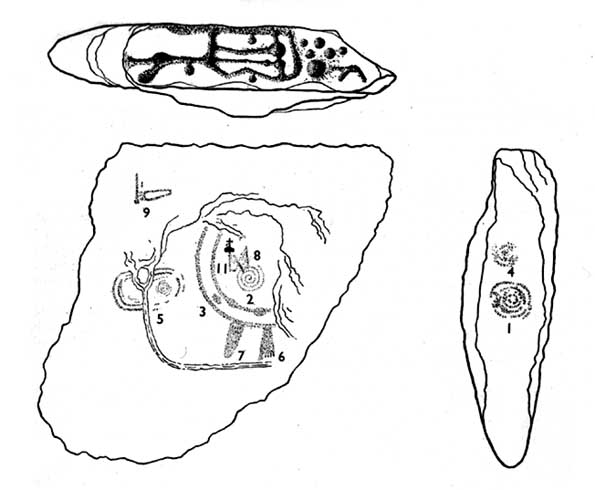
Earliest known drawing from 1825, showing the carvings
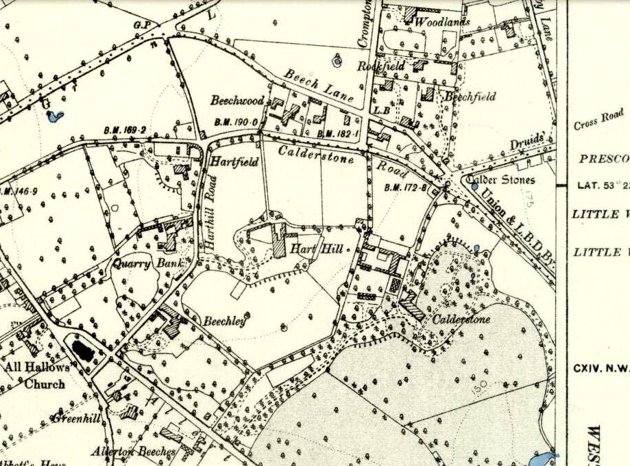
Marked on the 1846 Ordnance Survey map in a position by the road junctions at the meeting of township boundaries, where the aptly-named Calderstones Road and Druids Cross Road meet, several hundred yards north of its present site in Harthill Greenhouses in Calderstones Park, this is a completely fascinating site whose modern history is probably as much of a jigsaw puzzle as its previous 5000 years have been!
Thought to have originally have been a chambered tomb of some sort, akin to the usual fairy hill mound of earth, either surrounded by a ring of stones, or the stones were covered by earth. The earliest known literary reference to the Calderstones dates from 1568, where it is referenced in a boundary dispute, typical of the period when the land-grabbers were in full swing. The dispute was over a section of land between Allerton and Wavertree and in it the stones were called “the dojer, rojer or Caldwaye stones.” At that time it is known that the place was a roughly oval mound. But even then, we find that at least one of the stones had been taken away, in 1550.
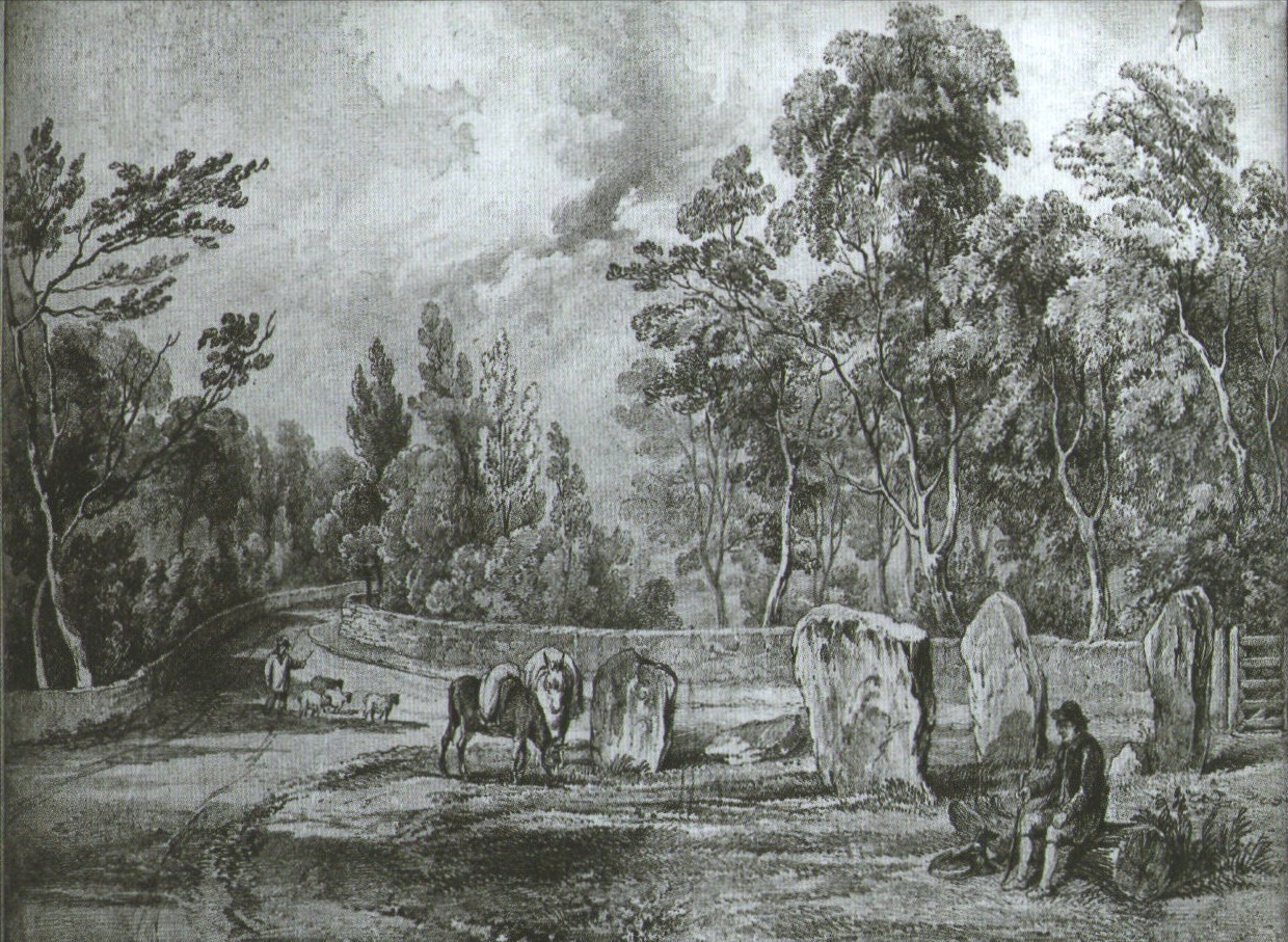
Little was written about the place from then until the early 19th century, when descriptions and drawings began emerging. The earliest image was by one Captain William Latham in 1825. On this (top-right) we have the first hint of carvings on some of the stones, particularly the upright one to the right showing some of the known cup-markings that still survive. By the year 1833 however, the ‘mound’ that either surrounded or covered the stones was destroyed. Victorian & Paul Morgan (2004) told us,
“The destruction first began in the late 18th or early 19th century when the mound was largely removed to provide sand for making mortar for a Mr Bragg’s House on Woolton Road. It was at this time that a ‘fine sepulchral urn rudely ornamented outside’ was found inside.”
The Calderstones in 1840
The same authors narrated the account of the mound’s final destruction, as remembered by a local man called John Peers—a gardener to some dood called Edward Cox—who was there when it met its final demise. Mr Cox later wrote a letter explaining what his gardener had told him and sent it to The Daily Post in 1896, which lamented,
“When the stones were dug down to, they seemed rather tumbled about in the mound. They looked as if they had been a little hut or cellar. Below the stones was found a large quantity of burnt bones, white and in small pieces. He thought there must have been a cartload or two. He helped to wheel them out and spread them on the field. He saw no metal of any sort nor any flint implements, nor any pottery, either whole or broken; nor did he hear of any. He was quite sure the bones were in large quantity, but he saw no urn with them. Possibly the quantity was enhanced by mixture with the soil. No one made such of old things of that sort in his time, nor cared to keep them up…”
But thankfully the upright stones remained—and on them were found a most curious plethora of neolithic carvings. After the covering cairn had been moved, the six remaining stones were set into a ring and, thankfully, looked after. These stones were later removed from their original spot and, after a bit of messing about, came to reside eventually in the curious greenhouse in Calderstones Park.
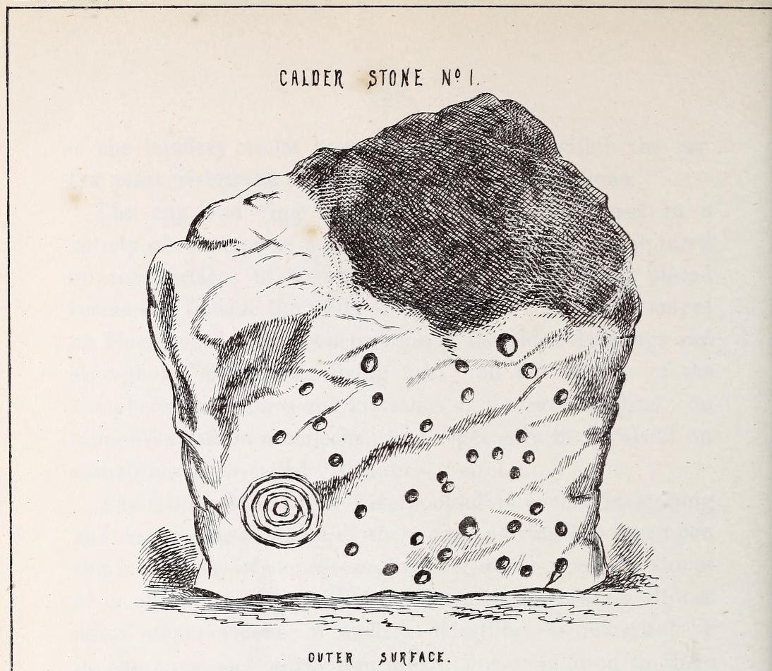
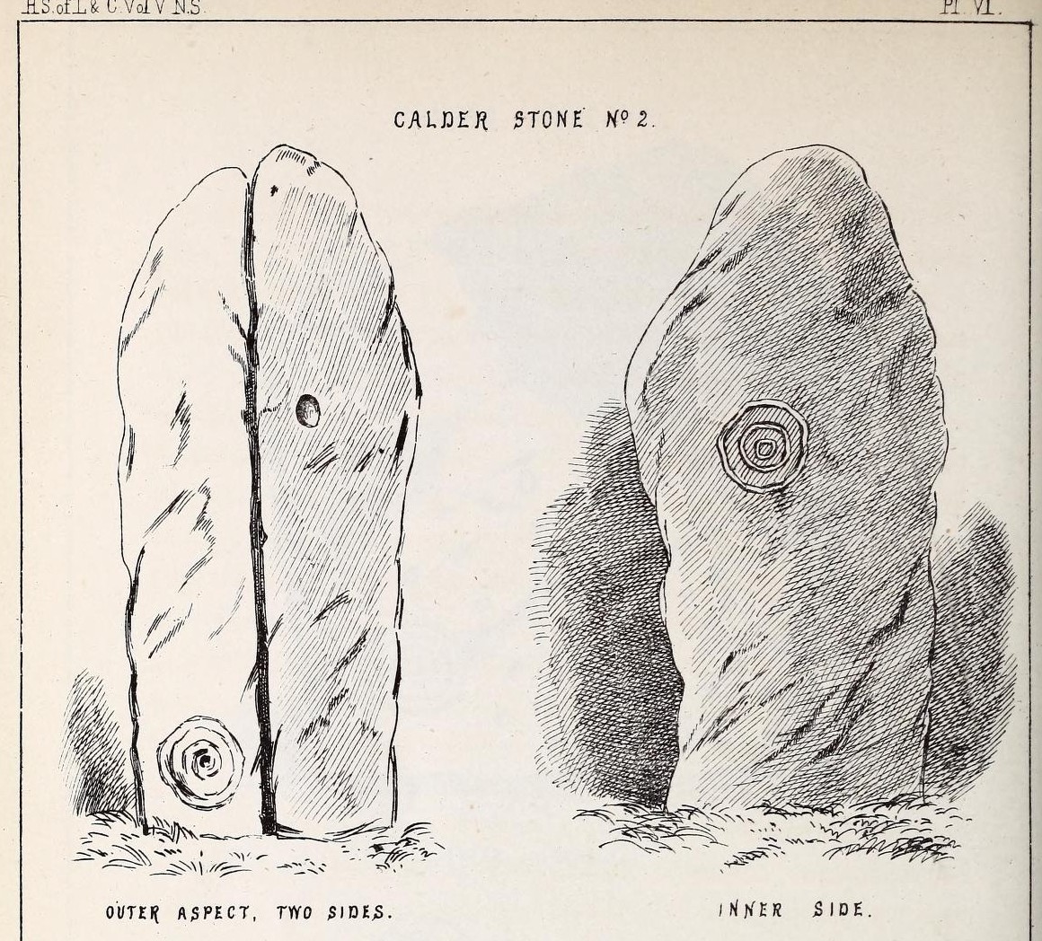
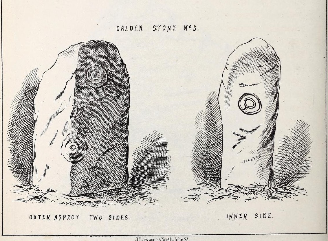
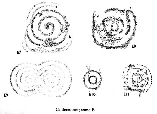
Simpson’s “Stone 1” outer faceSimpson’s “Stone 1” inner face
The carvings on the stones were first described in detail by the pioneering James Simpson. (1865) I hope you’ll forgive me citing his full description of them—on one of which he could find no carvings at the time, but he did state that his assessment may be incomplete as the light conditions weren’t too good. Some things never change! Sir James wrote:
“The Calder circle is about six yards in diameter. It consists of five stones which are still upright, and one that is fallen. The stones consist of slabs and blocks of red sandstone, all different in size and shape.
“The fallen stone is small, and shews nothing on its exposed side; but possibly, if turned over, some markings might be discovered on its other surface.
“Of the five standing stones, the largest of the set (No. I) is a sandstone slab, between five and six feet in height and in breadth. On its outer surface—or the surface turned to the exterior of the circle— there is a flaw above from disintegration and splintering of the stone; but the remaining portion of the surface presents between thirty and forty cup depressions, varying from two to three and a half inches in diameter; and at its lowest and left-hand corner is a concentric circle about a foot in diameter, consisting of four enlarging rings, but apparently without any central depression.
“The opposite surface of this stone, No. 1, or that directed to the interior of the circle, has near its centre a cup cut upon it, with the remains of one surrounding ring. On the right side of this single-ringed cup are the faded remains of a concentric circle of three rings. To the left of it there is another three-ringed circle, with a central depression, but the upper portions of the rings are broken off. Above it is a double-ringed cup, with this peculiarity, that the external ring is a volute leading from the central cup, and between the outer and inner ring is a fragmentary line of apparently another volute, making a double-ringed spiral which is common on some Irish stones, as on those of the great archaic mausoleum at New Grange, but extremely rare in Great Britain. At the very base of this stone, and towards the left, are two small volutes, one with a central depression or cup, the other seemingly without it. One of these small volutes consists of three turns, the other of two.
“The next stone, No. 2 in the series, is about six feet high and somewhat quadrangular. On one of its sides, half-way up, is a single cup cutting; on a second side, and near its base, a volute consisting of five rings or turns, and seven inches and a half in breadth ; and on a third side (that pointing to the interior of the circle), a concentric circle of three rings placed half-way or more up the stone.
“The stone No. 3, placed next to it in the circle, is between three and four feet in height; thick and somewhat quadrangular, but with the angles much rounded off. On its outermost side is apparently a triple circle cut around a central cup; but more minute examination and fingering of the lines shews that this figure is produced by a spiral line or volute starting from the central cup, and does not consist of separate rings. The diameter of the outermost circle of the volute is nearly ten inches. Below this figure, and on the rounded edge between it and the next surface of the stone to the left, are the imperfect and faded remains of a larger quadruple circle. On one of the two remaining sides of this stone is a double concentric circle with a radial groove or gutter uniting them. This is the only instance of the radial groove which I observed on the Calder Stones, though such radial direct lines or ducts are extremely common elsewhere in the lapidary concentric circles.
“The stone No. 4 is too much weathered and disintegrated on the sides to present any distinct sculpturings. On its flat top are nine or ten cups ; one large and deep (being nearly five inches in diameter). Seven or eight of these cups are irregularly tied or connected together by linear channels or cuttings…
“The fifth stone is too much disfigured by modern apocryphal cuttings and chisellings to deserve archaeological notice.
“The day on which I visited these stones was dark and wet. On a brighter and more favourable occasion perhaps some additional markings may be discovered.”
It wasn’t long, of course, before J. Romilly Allen (1888) visited the Calderstones and examined the carvings; but unusually he gave them only scant attention and added little new information. Apart from reporting that another of the monoliths had carvings on it, amidst a seven-page article the only real thing of relevance was that,
“Five of the Calderstones show traces, more or less distinct, of this kind of carving, the outer surface of the largest stone having about thirty-six cups upon it, and a set of four concentric rings near the bottom at one corner. One of the stones has several cups and grooves on its upper surface.”
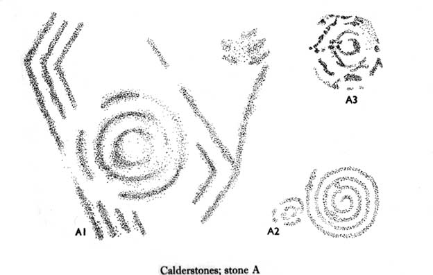
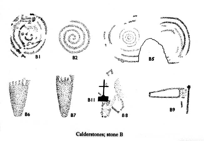
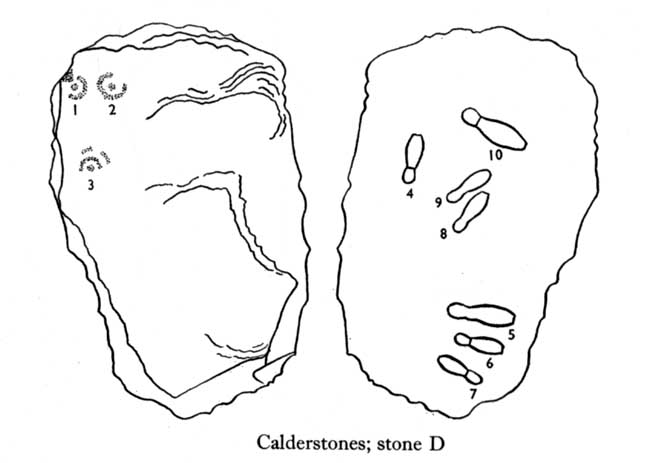
Carvings on Stone A (after Forde-Johnson)Carvings on Stone B (after Forde-Johnson)
Unusual for him! The major survey of the Calderstone carvings took place in the 1950s when J.L. Forde-Johnson (1956; 1957) examined them in great detail. His findings were little short of incredible and, it has to be said, way ahead of his time (most archaeo’s of his period were simply lazy when it came to researching British petroglyphs). Not only were the early findings of Sir James Simpson confirmed, but some fascinating rare mythic symbols were uncovered that had only previously been located at Dunadd in Argyll, Cochno near Glasgow, and Priddy in Somerset: human feet – some with additional toes! Images of feet were found to be carved on Stones A, B and E. A carved element on Stone C may even represent a human figurine—rare things indeed in the British Isles!
Carvings on Stone DCarvings on Stone E
The detailed sketches here are all from Forde-Johnson’s 1957 article, where five of the six stones were found to bear petroglyphs (the sixth stone has, more recently, also been found to also possess faint carvings of a simple cup-mark and five radiating lines).
Elements on Stone C (after Forde-Johnson)More elements on Stone C (after Forde-Johnson)
The date of the site is obviously difficult to assess with accuracy; but I think it is safe to say that the earlier archaeological assumptions of the Calderstones being Bronze Age are probably wrong, and the site is more likely to have been constructed in the neolithic period. It’s similarity in structure and form to other chambered tombs—mentioned by a number of established students from Glyn Daniel (1950) to Frances Lynch—would indicate an earlier period. The fact that no metals of any form have ever been recovered or reported in any of the early accounts add to this neolithic origin probability.
There is still a lot more to be said about this place, but time and sleep are catching me at the mo, so pray forgive my brevity on this profile, until a later date…
Folklore
Curiously, for such an impressive site with a considerable corpus of literary references behind it, folklore accounts are scant. The best that Leslie Grinsell (1976) could find in his survey was from the earlier student C.R. Hand (1912), who simply said that,
“They were looked upon with awe by the people about as having some religious significance quite beyond their comprehension.”
There is however, additional Fortean lore that has been written about these stones and its locale by John Reppion (2011).
Ashbee, Paul, The Bronze Age Round Barrow in Britain, Phoenix House: London 1960.
Baines, Thomas, Lancashire and Cheshire, Past and Present – volume 2, William MacKenzie: London 1870.
Beckensall, Stan, British Prehistoric Rock Art, Tempus: Stroud 1999.
Beckensall, Stan, Circles in Stone: A British Prehistoric Mystery, Tempus: Stroud 2006.
Cowell, Ron, The Calderstones – A Prehistoric Tomb in Liverpool, Merseyside Archaeological Trust 1984.
Crawford, O.G.S., The Eye Goddess, Phoenix House: London 1957.
Daniel, Glyn E., The Prehistoric Chamber Tombs of England and Wales, Cambridge University Press 1950.
Faulkner, B.M., “An Analysis of Three 19th-century Pictures of the Calderstones,” in Merseyside Archaeological Journal, volume 13, 2010.
Forde-Johnson, J.L., “The Calderstones, Liverpool,” in Powell & Daniel, Barclodiad y Gawres: The excavation of a Megalithic Chambered Tomb in Anglesey, Liverpool University Press 1956.
Forde-Johnson, J.L., “Megalithic Art in the North West of Britain: The Calderstones, Liverpool,” in Proceedings of the Prehistoric Society, volume 23, 1957.
Grinsell, Leslie, Folklore of Prehistoric Sites in Britain, David & Charles: Newton Abbot 1976.
Hand, Charles R., The Story of the Calderstones, Hand & Co.: Liverpool 1912.
Herdman, W.A., “A Contribution to the History of the Calderstones, near Liverpool,” in Proceedings & Transactions of the Liverpool Biological Society, volume 11, 1896.
Morgan, Victoria & Paul, Prehistoric Cheshire, Landmark: Ashbourne 2004.
Nash, George & Stanford, Adam, “Recording Images Old and New on the Calderstones in Liverpool,” in Merseyside Archaeological Journal, volume 13, 2010.
Picton, James A., Memorials of Liverpool – 2 volumes, Longmans Gree: London 1875.
Simpson, James, Archaic Sculpturings of Cups, Circles, etc., Upon Stones and Rocks in Scotland, England and other Countries, Edmonston & Douglas: Edinburgh 1867.
Taylor, Isaac, Words and Places, MacMillam: London 1885.
Stewart-Brown, Ronald, A History of the Manor and Township of Allerton, Liverpool 1911.
Acknowledgements: With huge thanks to the staff at Calderstones Park; thanks also to the very helpful staff at Liverpool Central Library.
The easiest way to find this is by going along the B9113 road that runs from the east side of Forfar, out to Montreathmont Forest. Along this road, pass the Rescobie Loch and keep going for another mile or so, until you hit the small crossroads. Go left here as if you’re going to Aberlemno. Barely 100 yards up, opposite the newly-built Westerton house, the standing stone is on the rise in the field.
Archaeology & History
The carved west-facing side
A truly fascinating heathen stone in a parish full of Pictish and early christian remains, with the faint remains of an intriguing carving that can still, thankfully, be discerned on the southwestern face of the upright….amongst other things…
Marked as a singular stone after the Ordnance Survey lads visited here in 1901, early mentions of the site are very scant indeed. In Sir James Simpson’s (1866; 1867) early masterpiece on prehistoric rock art, in which he named the place as the “Circle of Turin,” he related how his friend and associate Dr Wyse told him how this stone “once formed one of a fine circle of boulder stones at Nether Turin,” but said little more. (Simpson was the vice president of the Society of Antiquaries of Scotland, a professor of medicine, as well as being one of Queen Victoria’s chief physicians.) The “Dr Wyse” in question was very probably Thomas Alexander Wise, M.D., who wrote the little-known but informative and extravagent analysis of prehistoric sites and their folklore in Scotland called A History of Paganism in Caledonia (1884). Therein he told us:
“At Turin, in Forfarshire, there is a large boulder which had formed one of the stones in a circle. On the flat top are several cups arranged irregularly, and without any enclosing circles. This boulder stone is on the NW face of the circle. The other side was towards the SE, facing the rising sun.”
As a result of these early references the site is listed and documented, correctly, as a “stone circle” in Aubrey Burl’s (2000) magnum opus. We do not have the information to hand about who was responsible for the circle’s desctruction—but it was likely done by the usual self-righteous industrialists or christians. It is a puzzle therefore, why Barclay & Halliday (1982) sought to reject an earlier “megalithic ring” status as mentioned by Sir James and Dr Wise, with little more than a flippant dismissal in their short note on the Westerton stone. Unless those two writers can offer vital evidence that can prove that the Westerton standing stone was not part of a megalithic ring, we can of course safely dismiss their unsubstantiated claim.
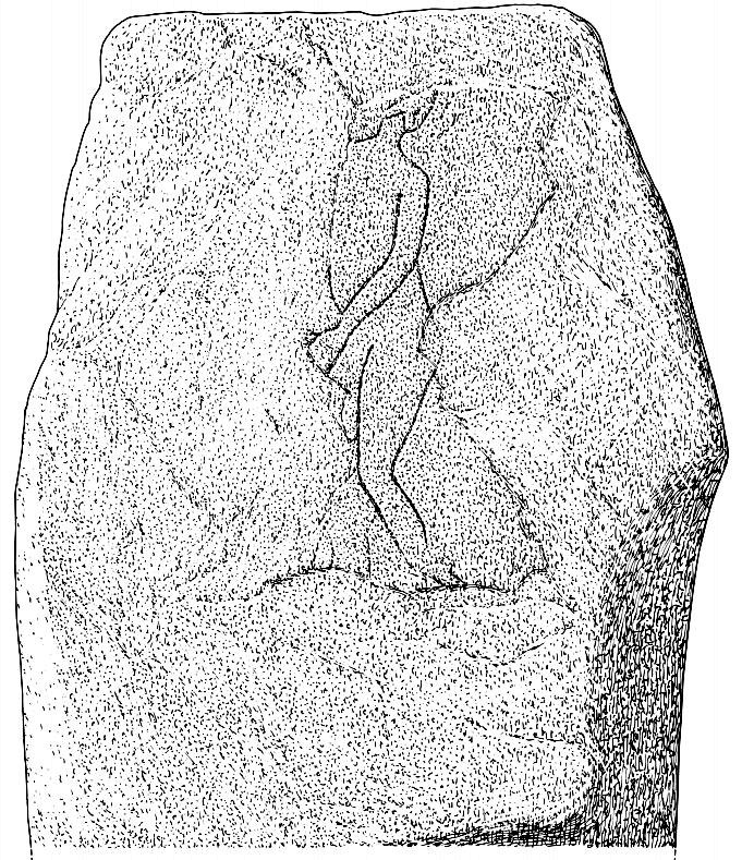
Despite this however, they do give us an intriguing description of a curious carving, faintly visible, of an upright male figure etched onto the west side of this standing stone. The carving has unfortunately been damaged—probably by intruding christians or puritans of some sad form. You’ll see why I’m blaming them in a minute! In their short account of the carving, Barclay & Halliday (1982) state:
“Much of the original surface of the SW face of the stone has scaled off, but, on the surviving portion, there is a part of a human figure…apparently naked, outlined by grooves, measuring between 5mm and 15mm in breadth and up to 7mm in depth. Of the head, only the lower part of the jaw and neck can be identified, and a second groove at the back of the neck probably represents hair or some form of head-covering. The left arm passes across the body into the lap and the arch of the back is shown by a groove which detaches itself from the upper part of the arm. The left leg is bent at the knee and is lost below mid-calf; from mid-calf to jaw is a distance of some 0.85m”
In interpreting this carving the authors make a shallow, if not poor attempt to describe what he may be doing, saying:
“The figure is viewed from its left side and is turned slightly towards the observer. The position of the left arm and leg may be compared with those of a fighting figure depicted on the Shandwick Stone, Easter Ross…but they may also reflect a riding posture; no trace of a mount, however, has survived.”
Damaged carving of a man doing summat with his cock!
Well – that is intriguing. But we have to recognise that our authors work for the Royal Commission, which may have effected their eyes and certainly their minds—as everyone else sees something not drawn out of Rorscharch’s famous psychology test! When I put the drawing you can see here (left) onto various internet archaeology group pages (including the Prehistoric Society, etc) the response was virtually unanimous, with some comical variants on what the carved man is doing — i.e., masturbating, or at least committing some sort of sexual act, possibly with another creature where the rock has been hacked away by the vandals. But a sexual act it is! Although such designs are rare in Britain, they are found in prehistoric rock art and later architectural carvings in most cultures on Earth. The nearest and most extravagant examples of such sexual acts can be found in the Scandinavian countries, where fertility images are profuse, often in tandem with typical prehistoric cup-and-ring designs. (see Coles 2005; Gelling & Davidson 1969, etc)
Line of cup-marks on top of stone
…And, on the very top of the stone, running along its near-horizontal surface, a line of six cup-markings are clearly visible. Intrusions of natural geophysical scars are also there, but the cup-marks are quite distinct from Nature’s wear, all on the west side of the natural cut running along the top. These cup-marks were first mentioned in Simpson’s (1866; 1867) early tome, where he told how his “esteemed friend Dr Wyse discovered ‘several carefully excavated cavities upon its top in groups, without circles.'” Whether these neolithic to Bronze Age elements had any association with the later Pictish-style wanking fella (fertility?) is impossible to know, sadly…
References:
Barclay, G.J. & Halliday, S.P., “A Rock Carving from Westerton, Angus District,” in Proceedings of the Society of Antiquaries, Scotland, volume 112, 1982.
Burl, Aubrey, The Stone Circles of Britain, Ireland and Brittany, Yale University Press 2000.
Coles, John, Shadows of a Northern Past, Oxbow: Oxford 2005.
Gelling, Peter & Davidson, Hilda Ellis, The Chariot of the Sun and other Rites and Symbols of the Northern Bronze Age, J.M. Dent: London 1969.
Sherriff, John R., “Prehistoric Rock Carvings in Angus,” in Tayside & Fife Archaeological Journal, volume 1, 1995.
Simpson, James, Archaic Sculpturings of Cups, Circles, etc., Upon Stones and Rocks in Scotland, England and other Countries, Edmonston & Douglas: Edinburgh 1867.
Wise, Thomas A., History of Paganism in Caledonia, Trubner: London 1884.
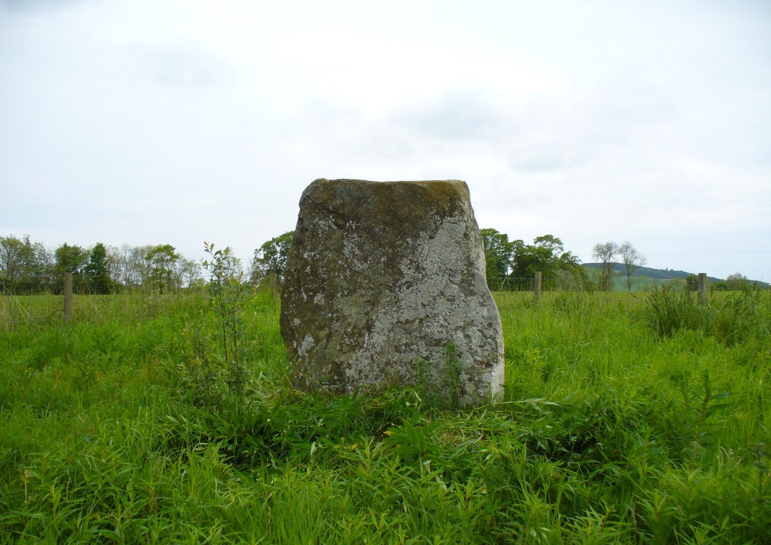
Various ways to get here: from Bathgate either take the Drumcross Road eastwards and up, or north up the Puir Wife’s Brae till you reach the crossroads where, upon the hillock north, you’ll see the old stone standing on the ridge. If you come down from Cairnpapple Hill (as most visitors are likely to do), go south for more than a mile and keep your eyes peeled in the fields to your right, shortly before the staggered crossroad. You can’t really miss it.
Archaeology & History
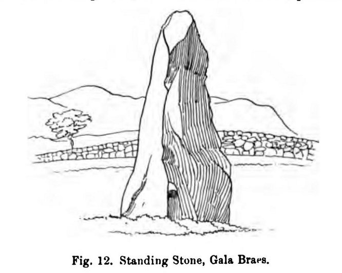
Gala Braes standing stone
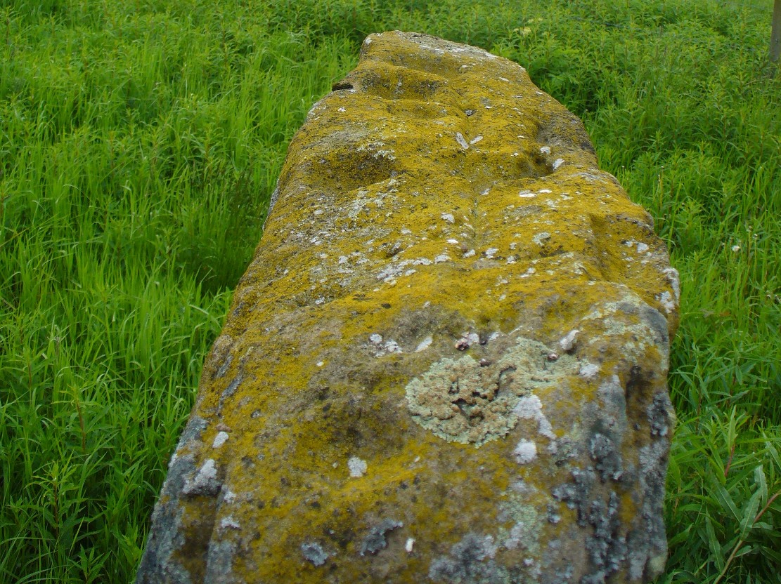
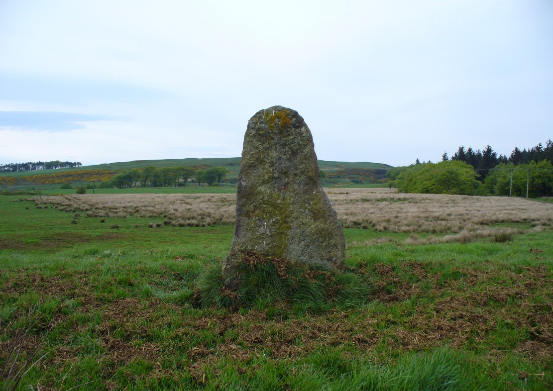
About a mile south of the superb Cairnpapple Hill, in a well-manured field at the edge of a small ridge with a vast view to the south and west, this now-solitary standing stone lives quietly and alone, gazing over its old landscape. Standing about 5½ feet tall, it seems as if the monolith has been split along its southern side at some time in the not-too-distant past, leaving a damaged wedge-shaped monolith, with one very thin eastern edge and a wider western side. The stone itself was erected to align roughly north-south-east-west.
The monolith was first shown on the 1854 Ordnance Survey map of the region, along with its fallen companion (Gala Braes 2) nearly 75 yards to the west, but descriptions of the place by antiquarians are scarce. Not until Fred Coles (1903) visited here did we gain a decent account. He wrote:
“I examined this site in August 1902. It is about a mile to the east of Bathgate, and occupies the summit of a ridge extending some 300 feet westwards of the byroad that branches off due N, near the farm of Clinkingstane. The ridge is about 850 feet above sea-level. On reaching it, I found but one Standing Stone,—a rough whinstone boulder, split very unevenly, and jagged on the south side, very smooth on the two shorter sides, and girthing at the base 10 feet 5 inches. The longest edge trends WNW and ESE. It stands 5 feet 3 inches high and occupies the highest spot on the ridge.”
Whilst Mr Coles was pottering about, the courteous local farmer approached him and they began chatting about the old place—as tends to happen more than often in olde Scotland. When he,
“…asked if any digging had ever been made at either of these stones, Mr Carlaw replied that many years ago an old Bathgate worthy known as “The Apostle” persuaded his (Carlaw’s) father to dig at the base of the upper Standing Stone (the one at present erect), and they found human bones. The farm of Gala Braes has been in the tenancy of a Carlaw for upwards of a century.”
Whatever became of the old bones isn’t known. A few years later, the Royal Commission (1929) lads bimbled over to check the place out and found that it was still very much as Coles had described more than twenty years earlier, but added, “it bears no trace of sculpture.” This has since changed. Faint outlines of lettering, seemingly only a hundred years old perhaps, have been etched onto its northern face. As for the etymology of this place, Coles (1903) suggested:
“Assuming, however, that the bones found at the upper Stone were human, and taking cognisance of the fact that throughout Scotland there are many knowes, hills, hillocks and laws which are distinguished by the epithet Gallow or Gala, and that in or at many of these human remains and interments (some of them prehistoric) have been discovered, we may place this site on the Gala Braes of Bathgate in the same general group.”
Gala Braes, with Cairnpapple Hill to rearFred Coles’ 1903 drawing
Curiously he makes no mention of the nearby ‘Clinkingstane’ a few hundred yards east: an etymological curiosity that Angus MacDonald (1941) thought may have derived from a “knocking stone”; but is a word with hosts of dialect meanings, making it difficult to define with any real certainty (at the moment anyway). Just past the Clinkingstane we had the “cross on the ridge” of Drumcross—on the same ridge as our standing stones—which may well have been an attempt to keep people away from our older, more authentic heathen heritage.
The late great Alexander Thom (1990:2:341) also visited the site, but despite its impressive landscape setting and relative proximity to Gala Braes 2, he could find no astronomical orientations here. For Thom, that’s a feat in itself!
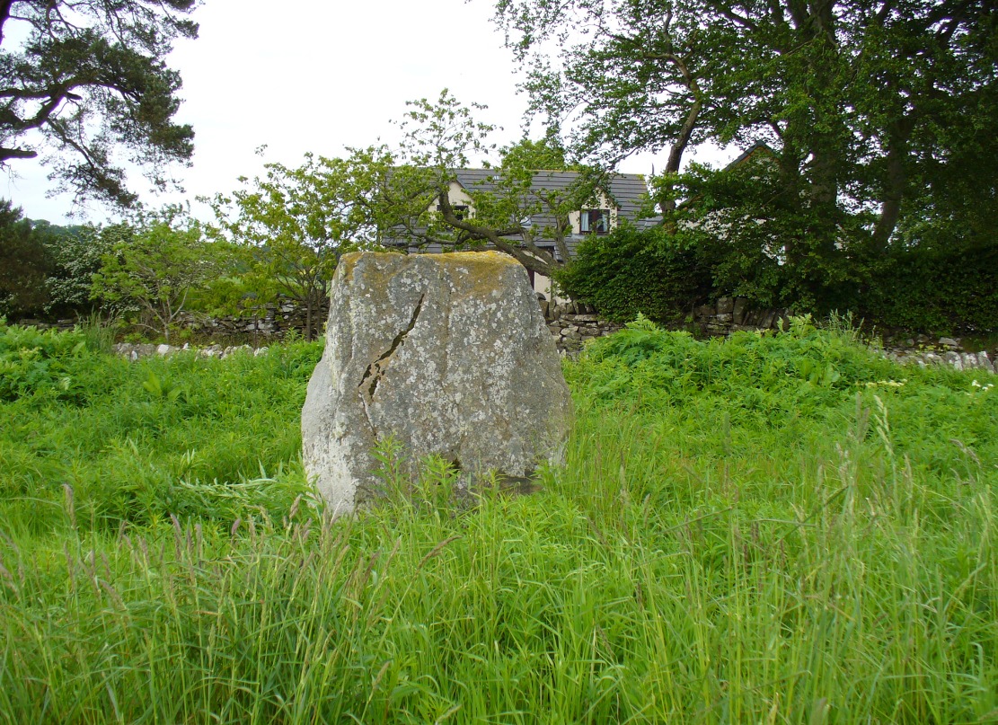
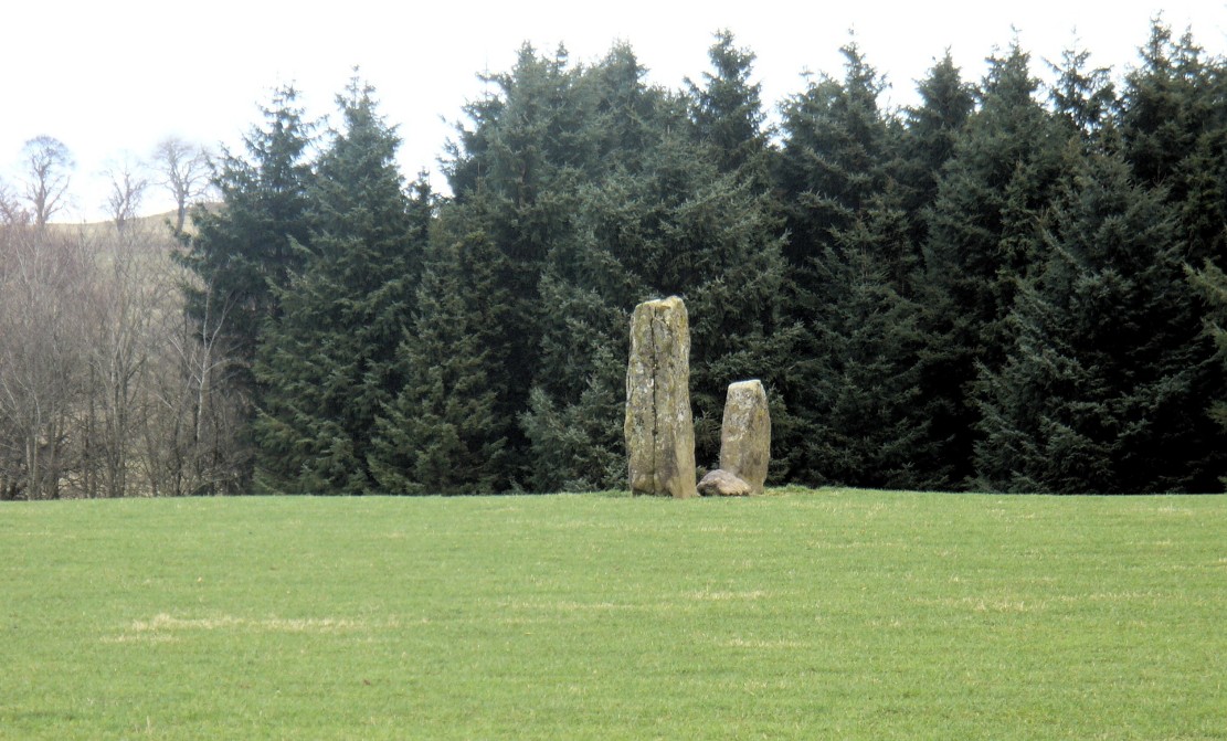
Take the A823 road up from Gleneagles to Glendevon and at the top of the long hill, where the road starts to level out and slightly drop, where the two glens meet up, take the right turn (west) and park up by the cattle-grid. Walk back onto the A823 and walk about 200 yards south towards Glendevon, to the small copse of trees past the cottage. As you get to the trees, look by the fencing and you’ll see one archetypal rounded standing stone, with another one next to it. You’re here!
Archaeology & History
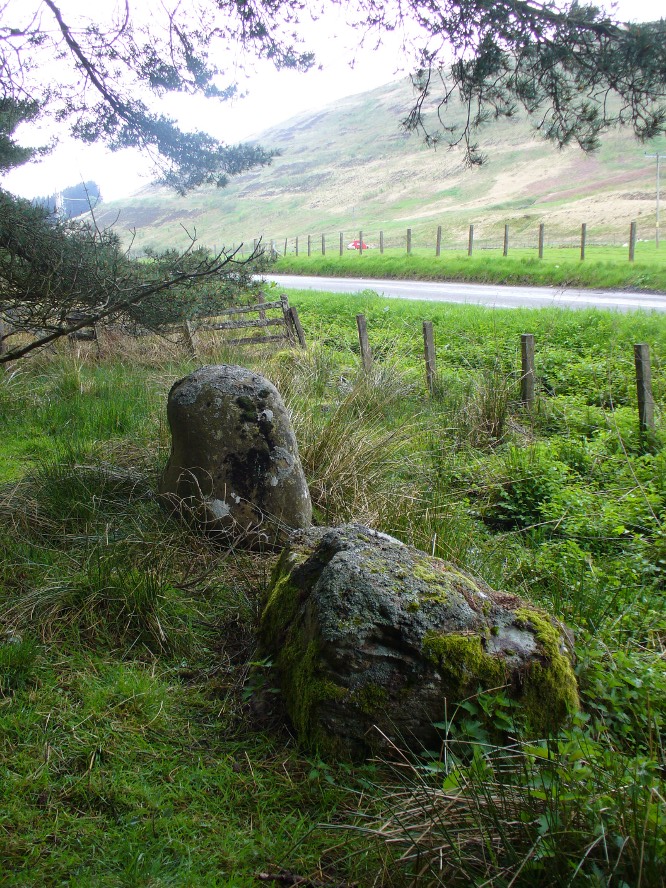
Stones by the roadside at Fourstanes
At long last my huge nose is twitching back to its authentic sniffing-out lost sites in the landscape. During a visit to the St. Mungo’s Well a few days ago, on the way back to the car I kept saying to my fellow antiquarian Paul Hornby that “there’s something missing round here.”
“Wotcha mean?” he said.
“Summat missing Paul. It feels there should be a four-poster or summat like that here — where the two glens meet up. I can smell it. Summat should be here, or was here in the past.”
I said it several times as we walked back along the old track to the car. We took the photos and he set off to give me a grateful lift back home. But as we got back onto the road, we noticed a couple of upright stones just set back at the edge of a small copse of trees. One was very rounded and about four-feet tall, with a smaller companion next to it. But we didn’t stop to check them out as it was getting late.
A few days later Paul rang me to ask if I’d had a look at the old maps of the region where we’d visited and seen the old place-name where we’d been.
“No, why?”
“It’s known as the ‘Four Stanes’,” he said. “And right where those stones were standing by the trees!”
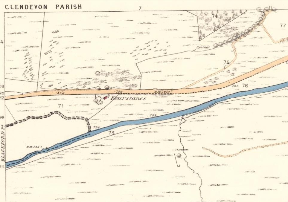
A few happy expletives came out, as usual for me. So I sought out the map he was talking about and, as we can see above, the “Fourstanes” (or Stones) are right where my ‘feelings’ and the stones were seen.
On the 1860 Ordnance Survey map of the area, a small building is shown and named as ‘Fourstanes’ right by the roadside, on the south side. It was also named as such in an earlier account of 1851 and was told to be inhabited by a Mrs Foote in 1866. Sometime after this the cottage appears to have been left to neglect and no trace of it now remains. According to evidences of the place-name societies in England and Scotland and the studies of Smith (1956), Scott (2004) and others, unless the term derives from the Gaelic fuar, meaning cold or chilly, it is usually evidence of ‘four stones’ in relation to megalithic remains like those found from Shetland to the more southerly counties in England. Dr Aubrey Burl (1988) shows clearly in his textbook of the same name, that “four poster stone circles” are common megalithic architectural features in the Perthshire landscape — where this happens to be! He also states that such place-names should be listed and checked as possible “sites of destroyed four posters.” So we did just that!
Although the stones look very good contenders in the photos and also when you first see them close up, there are some elements here that need highlighting that throw a more sceptical view of them as authentic megaliths. The larger of the two stones—very rounded and worn, typical of other four-poster remains—is three feet high. The lichen vegetation covering it on all sides is old—except on its back (northern) upright face, where there is almost no vegetation at all. Indeed, this face is almost entirely clear of any natural plant growth, showing it was moved into this position from a lower horizontal level and pushed upright, I would say within the last century. The smaller, lower stone next to this upright oddity, is laid down and covered on all sides by an excess of vegetation expected of a monolith that has been in this position for several centuries at least. The lichen growth on this stone is very old.
Both of these stones occur along the line of an old wall and may have originally been a part of such a structure, instead of any four poster megalithic feature. However, the road that runs past here replaced the earlier track (which you can still walk along on the other side of the river 100 yards away) running through Glen Devon and into Glen Eagles. This “new road” as it was then, was made sometime in the 19th century. It may be that, upon the construction of the new road, the ‘fourstanes’ themselves were “in the way of Progress” (as they like to say) and so were rolled down the side of the new road and into the position they now occupy. It’s difficult to say.
There is one additional element that needs exploring. The hill immediately above Fourstanes is called ‘The Law.’ Although this word can be a simple “hill”, there are additional historical factors to a place-name. In Laurence Gomme’s (1880: 260-77) excellent work on the subject, he illustrates time and again across Scotland that heathen gatherings, tribal meetings and early court sessions or ‘moots’ were held at places with this place-name element. It should come as no surprise then, that at other megalithic sites in Britain called the Four Stones, ancient pagan moot were also held there. (Gomme 1880; Grinsell 1936, 1976)
We’re going back onto The Law itself in the next week or two, just to see if these ‘fourstanes’ are hiding away in the heather on the tops, where oh so many megalithic rings tend to be found….
…to be continued…
References:
Burl, Aubrey, Four Posters: Bronze Age Stone Circles of Western Europe, BAR 195: Oxford 1988.
Dwelly, Edward, The Illustrated Gaelic-English Dictionary, Gairm: Glasgow 1973.
A variety of ways to get here, all depending on which directions you’re coming from, obviously! Simply get to the sleepy old hamlet of Brunton, SW of Creich Castle ruins, and at the north end of the village where the road hits a T-junction, turn left and stop at the next house (hidden amongst trees) a coupla hundred yards along on the right-hand side. Knock on the door of The Manse (marked as such on the OS-maps) and ask. The fella who we met here, Liam, was very helpful and guided us to the site up the far end of his garden.
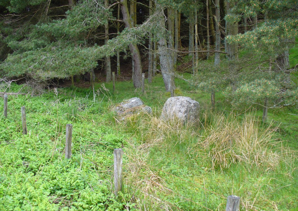
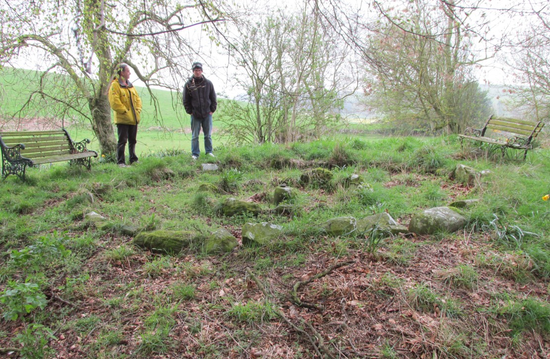
Archaeology & History
The small central ring
A truly fascinating and enigmatic arena for a host of reasons. The small and well-preserved ring of stones up the slope behind Creich Manse — looked after and recently cleared of covering vegetation by the present tenant — wasn’t born here, but originally lived more than a mile to the southwest, on the grounds of Luthrie House near the OS grid-reference NO 313 195. They were apparently under threat of being damaged and so, as James Taylor (1875) told, a “Mr Lawson got them removed, and placed them in a wood behind his manse in the very form in which they were found.”
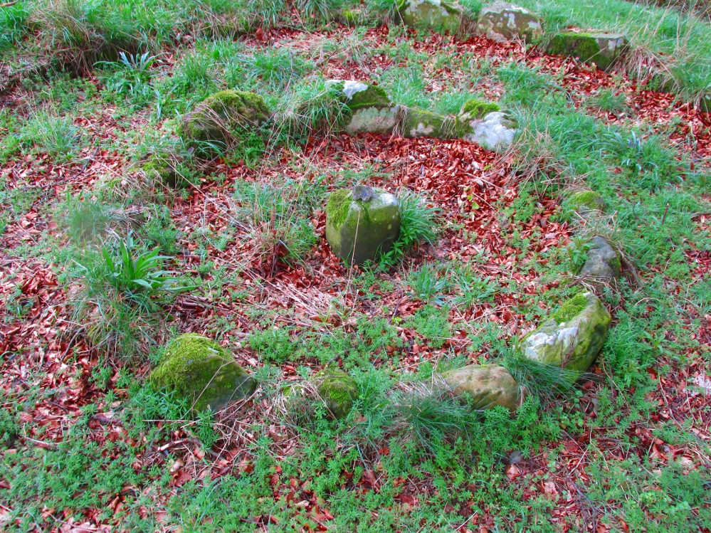
Curiously omitted from the giant surveys of Aubrey Burl (2000) and other modern academics, the place was first mentioned in the New Statistical Account of the parish by Alexander Lawson. It told that in 1816 “trenching operations” were being undertaken in Luthrie village when, at some point, the men came across a curious group of stones that seemed to have faint carvings upon them — in the centre of a ring of stones! The land-owner and parish minister were called to the site and they found that a double stone circle had been unearthed. The account told:
“In the centre was placed, in an upright position, a cylindrical sandstone, one foot two inches high, and having the diameter of its base one foot. Around this stone, as a centre, at the distance of three feet, were sixteen other stones, placed also in an upright position, and in the form of a circle. The stones of which it was composed were of various sizes, from fifteen to twenty inches in height; from eight to eighteen in breadth, and from four to nine in thickness. Due south of the centre, and between it and the inner circle, there were placed in a horizontal position, two stones containing hieroglyphics in alto relievo, very entire. The remaining space between the centre and the circle was laid with pavement. At the distance of seven feet and a half from the same central pillar, there was another circle of stones, thirty-two in number, placed in an upright position, and very much resembling those of the inner circle. The stones in both circles were placed close together. Between the circles there was neither pavement nor stone of any description. Neither were perfect circles, the diameter of one from north to south, being fifteen feet one inch, while its diameter from east to west was only fourteen feet nine inches; in the same manner, the diameter of the other, from east to west, was five feet ten inches, while from north to south it was it was six feet one inch.”
Ground-plan of the circleCreich ring, looking west
The account went on to describe there being a deposit of “burned human bones and charcoal” at the centre, below the larger of the two petroglyphs. Additionally, in one of those peculiarly common traits found at a number of megalithic remains, the Royal Commission (1933) lads pointed out that “it is remarkable that all the stones of the inner circle were of sandstone, which is not found nearer than Cupar, seven miles away, while those of the outer circle were of the local whinstone.”
Another description of the site was given in James Campbell’s (1899) updated and revised magnum opus on the parish of Balmerino, where some additional remarks were made about the petroglyphs. He told:
“Under one of the sculptured stones were found small burnt human bones and ashes. They were not enclosed in a cist, nor was there any building under the surface. Certain of the figures cut on one of the slabs of this monument are very similar to the figures on the sculptured slab of the one already mentioned. There are what appear to be representations of the soles of a pair of shoes, a circle with a cross within it — the limbs of the cross being: at right angles to each other — which may be intended to represent a wheel. On one of the stones is the figure of a spade. What the other figures represent is more uncertain. The sculptures raise difficult questions in regard to the time of the erection of these monuments. It is evident that cremation had been then practised at Creich, though the degree of culture and art indicated by the sculptures seems to point to a time subsequent to the abolition of this pagan custom elsewhere.”
Creich Circle petroglyphsCreich Ring, looking east
The carvings illustrated here are pretty unique in terms of them being standard prehistoric petroglyphs, as they seem to comprise more of a mix of Iron Age and Romano-British designs – though potentially we must take into account that they could be a form of Pictish. This region is littered with the remains of Picts, in place-names, folklore and archaeology. As such, it would be very helpful if someone qualified in Pictish studies could examine these designs. We do find petroglyphs of similar forms to this in Bronze Age Scandinavia and Iberia − but not Fife!
Folklore
In the only account of any folklore relating to this site, James Campbell (1867) told that local people said the place was “supposed to have marked the tombs of distinguished chiefs.”
References:
Burl, Aubrey, The Stone Circles of Britain, Ireland and Brittany, Yale University Press 2000.
Campbell, James, Balmerino and its Abbey – Volume 1, William Blackwood: Edinburgh 1899.
Along the A822 road between Crieff and Muthill, take the small western country lane just as you’re coming out of Muthill. Nearly 2 miles on, take the turn to the right, and then 100 yards or so from there turn sharp left. Keep along this country lane for about a mile till you reach the third track on your left. Walk down the track and you’ll see the standing stones in the field on your left. A gate into the field is by the house.
Archaeology & History
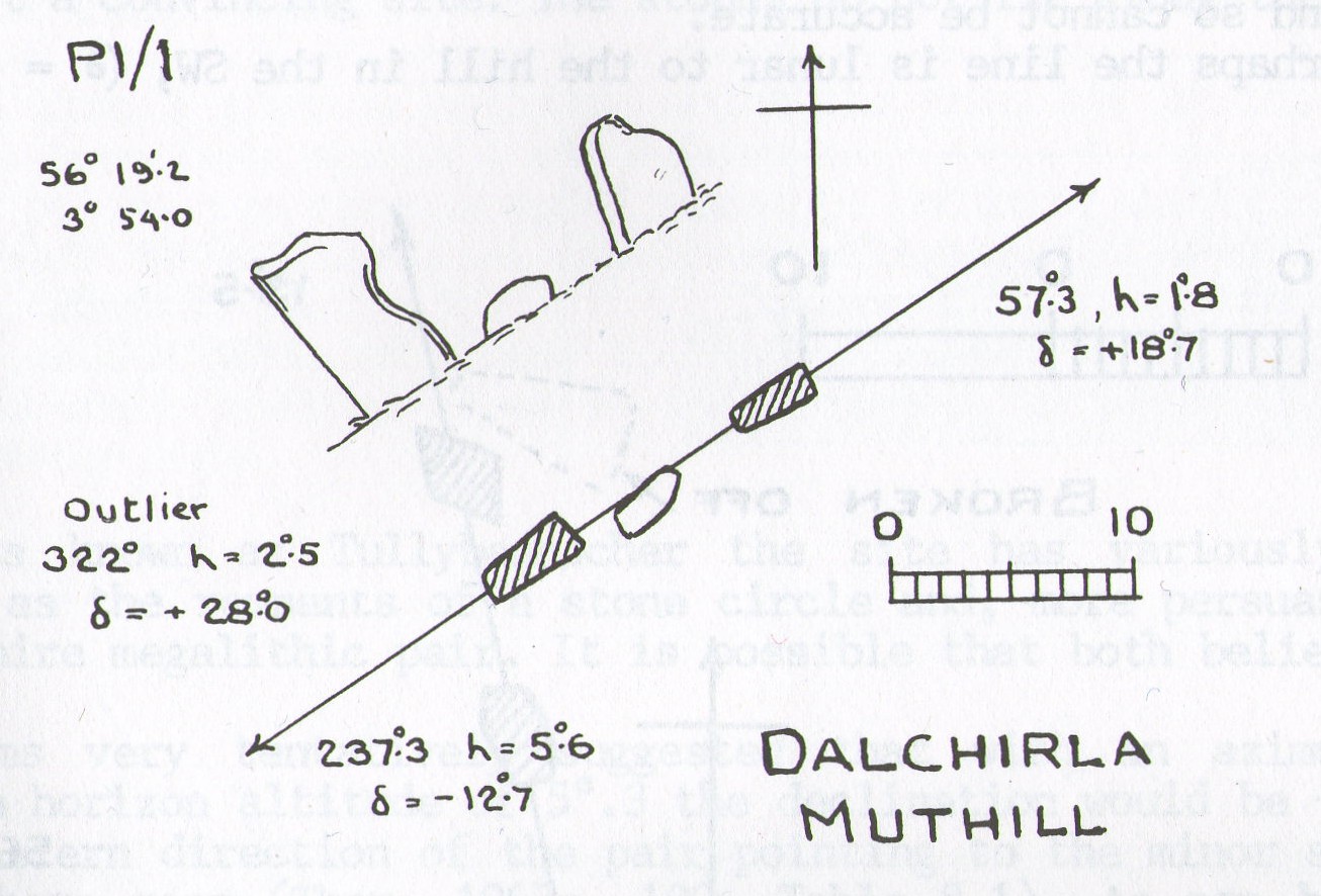
A fascinating pair of relatively large standing stones 317 yards (289.5m) SSE of the tall singular monolith of Dalchira North in the adjacent field. Traditionally said to have once been part of s stone circle, it was marked as such when the Ordnance Survey lads came here in 1863, but there is very little evidence of such a megalithic ring today—and even the small stone lying in between the two uprights is probably a more recent addition to the site. It certainly wasn’t mentioned by Fred Coles (1911) when he came here, who gave only a brief description of the place.
Dalchira East & the skyline notch of Lurgan HillDalchira, looking east
The stones were included in Margaret Stewart’s (1968) list of megalithic pairings as measuring 7ft 6in x 4ft 3in x 2ft and 4ft 3in x 3ft 6in x 1ft respectively, and 8ft apart. There is a small stone laid down in between them which has cup-marks on it, but these indentations are natural nodules in conglomerate rock. But the measurements and angles of Dalchira East were examined by the late great Alexander Thom (1967; 1990) who thought they had been positioned specifically to observe and predict lunar movements across the sky, saying that the alignment of these stones “shows the declination of the Moon rising at the minor standstill.” He may have been right.
Thom’s geometry of Dalchirla
In Aubrey Burl’s notes to Thom (1990) he told that the size and shapes of these stones, “have been interpreted as anthropomorphic, the taller, or alternatively the more pointed , usually at the west, being the male, the lower or flat-topped he female.” He subsequently included this site in his own work on megalithic stone rows (Burl 1993), without further comment.
Tis a peculiar site inasmuch there doesn’t seem to be much ‘feeling’ to the place. I’m sure the site is gonna have its days, but more than likely the neat and tidy farmed theatre has subsumed the genius loci to all but the most auspicious of times—most likely generated when the pull of the Moon still tugs at any geomagnetic background memory… Still, it’s definitely worth looking at.
References:
Burl, Aubrey, From Carnac to Callanish, Yale University Press 1993.
Coles, Fred, “Report on Stone Circles Surveyed in Perthshire, Principally Strathearn” in Proceedings of the Society of Antiquaries, Scotland, volume 45, 1911.
Heggie, Douglas C., Megalithic Science: Ancient Mathematics and Astronomy in Northwest Europe, Thames & Hudson: London 1981.
Stewart, Margaret E.C., “Excavation of a Setting of Standing Stones at Lundin Farm near Aberfedly, Perthshire,” in Proceedings of the Society of Antiquaries, Scotland, volume 98, 1966.
Thom, Alexander, Megalithic Sites in Britain, Oxford University Press 1967.
Thom, A., Thom, A.S. & Burl, Aubrey, Stone Rows and Standing Stones – 2 volumes, BAR: Oxford 1990.
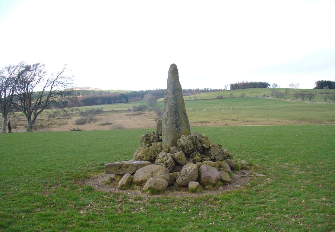
Along the A822 road between Crieff and Muthill, take the small western country lane just as you’re coming out of Muthill. Nearly 2 miles on, take the turn to the right, and then 100 yards or so from there turn sharp left. Keep along this gorgeous country lane for about a mile till you reach the third track on your left and park up. Walk down the track and you’ll see the standingh stone in the field on your right. Go all the way to the bottom where the farm is and go through the gate into the field.
Archaeology & History
The slim end of the wedge
Less than 2 miles southeast of the megalithic titan of Dunruchan A, we find a slightly smaller monolith positioned on lower ground and humbled by a more manicured landscape close to the farmhouse. But it’s still a big fella, albeit hemmed in by a mass of field clearance rocks piled up and around the base (two of which have odd carvings on them). The stone is about ten-feet tell, being very slim on its north-south side and much wider on its east-west face. For some reason I got the impression that the stone wasn’t standing in its original position; though in searching through my megalith library for further information on the site, l found that very little has been written about it. The earliest literary evidence comes, as usual, from Fred Coles (1911), who simply told us:
“In a field south of Machany Water and NE of Dalchirla farm-steading 260 yards, there stands this tall and striking monolith… In essential features this stone much resembles most of the great schistose blocks which characterize the main portion of the Strathearn area; but it tapers upwards to a very thin and narrow summit that rather distinguishes it from its fellows. It stands 9 feet 4 inches above ground, and girths at the base 7 feet 11 inches. It is set with its longer axis due north and south. Around its base there are several large masses of stone—not earthfast—amid a conglomeration of smaller pieces evidently cleared off the field.”
Fred Coles’ 1911 drawing
The prehistoric cairn of Torlum to the north may have had some significance to the setting of the stone, but without excavation and details of its original site, we’re just grasping at straws when it comes to evaluating any potential geomancy or landscape relationships—with the megalithic stone row in the next field perhaps being an exception!
The moorlands above here, stretching for many a mile, is apparently lacking in any prehistoric remains if you listen to the official records. But with the Dunruchan megalithic complex only two miles away and the once-giant tomb of Cairnwochel over the southeastern horizon, we know that cannot be possible… Watch this space!
References:
Coles, Fred, “Report on Stone Circles Surveyed in Perthshire, Principally Strathearn” in Proceedings of the Society of Antiquaries, Scotland, volume 45, 1911.