A couple of miles east of Crieff, take the A822 road from the Gilmerton junction towards the Sma’ Glen. After literally 1¾ miles (2.8km)—just 100 yards before the track up to Connachan Farm—you’ll reach a dirt-track on your left that leads into the hills. Go along here for 250 yards (230m) yards (the track has straightened out here) and then walk into the reeds on your right. About 15 yards in, look around!
Archaeology & History
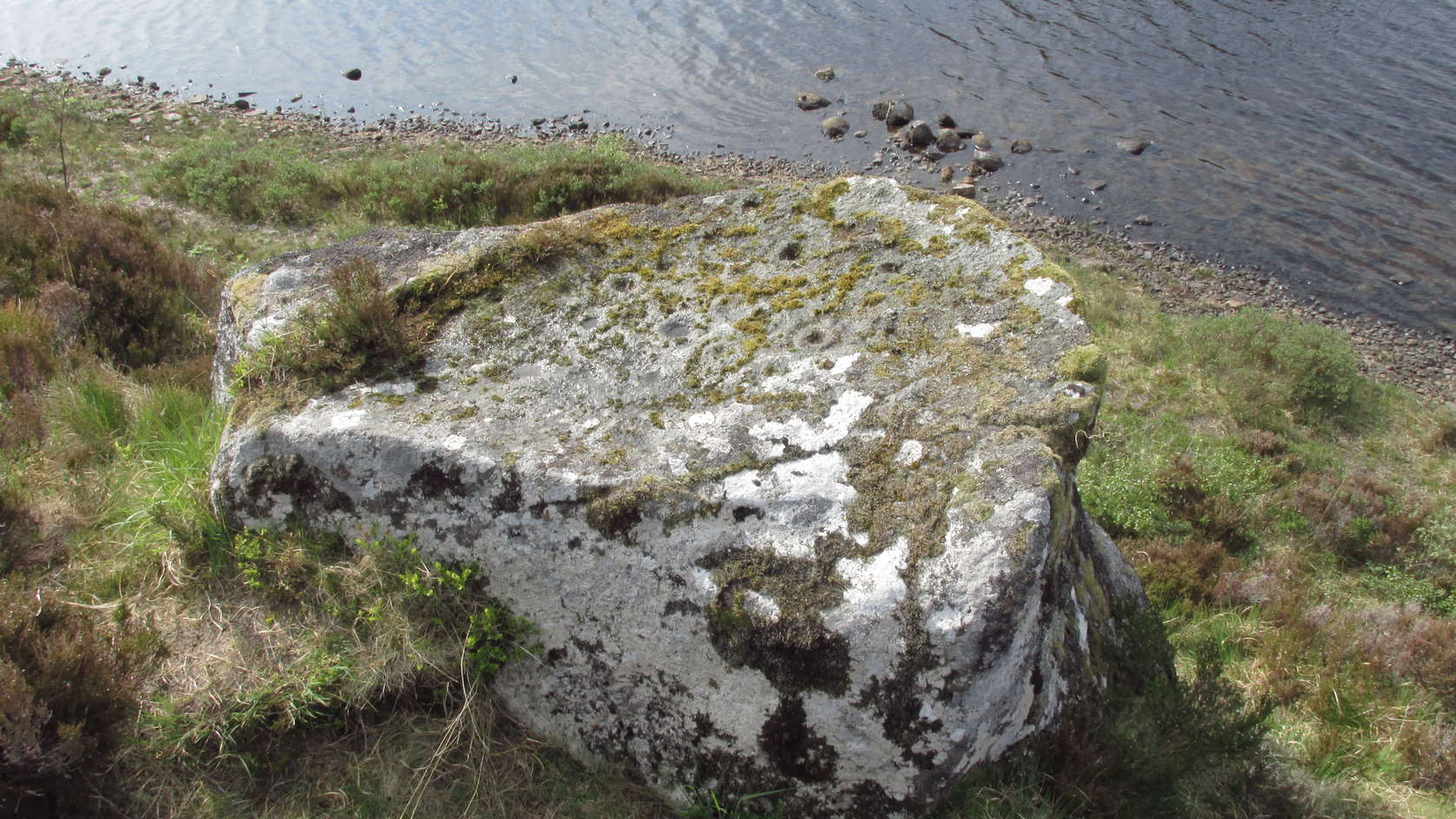
Another one of those fascinating carvings that had me here for an hour, maybe more, poring over more and more features as the light, shadow and rock gave more and more depending on how I looked at it. Tis the same with many petroglyphs, of course… But I liked this one.
On initial impression it didn’t seem up to much: maybe a few faint cups—some certain, others no so much. But the more attention we gave this stone, so more of those unlikely faint cups became much more real. At first there were a dozen; then 15 or more; but as we gave it more and more attention, so more of the petroglyphic design showed its original form. They do that, these stones! When George Currie rediscovered this carving in 2008 he found 17 cup-marks on the stone, but at least thirty of them go to make up this petroglyph. There may even be a very faint, albeit incomplete ring around one of them, but I’ll let the computer-tech kids work that one out!
Natural cracks with cups & carved extensionsNatural cracks with cups & carved extensions
This carving has that peculiar and not-too-infrequent element of having some cups carved into the natural cracks in the stone. In this case, at least four of them can be seen etched into the large deep crack that runs along its more northern edge. They’re quite distinct once you get your focus on them. In this case—albeit it to a much lesser extent—this feature reminded me of the impressive West Strathan carving in Sutherland. But where this natural crack finishes, it has been artificially extended until it reaches the eastern edge of the stone. You’ll also notice in the photos highlighting this feature, that another artificial line has been carved at right-angles to it, heading south, until it meets another natural crack in the stone. It’s quite distinct. And along this second artificial line, you’ll notice another cup or three—one of which has been cut into the line. These two man-made extended cracks in the stone, give the simple impression of an early cross symbol. Features such as this, whilst seemingly trivial to the bog standard explorer, possess some very curious myths in some living traditions elsewhere in the world; but such things are beyond the remit of this site profile.
References:
Currie, G., “Falls of Monzie, Perth and Kinross (Crieff parish), Cup-marked rock”, in Discovery & Excavation Scotland (New Series) volume 9, 2008.
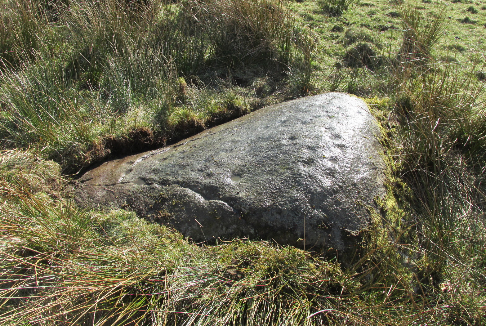
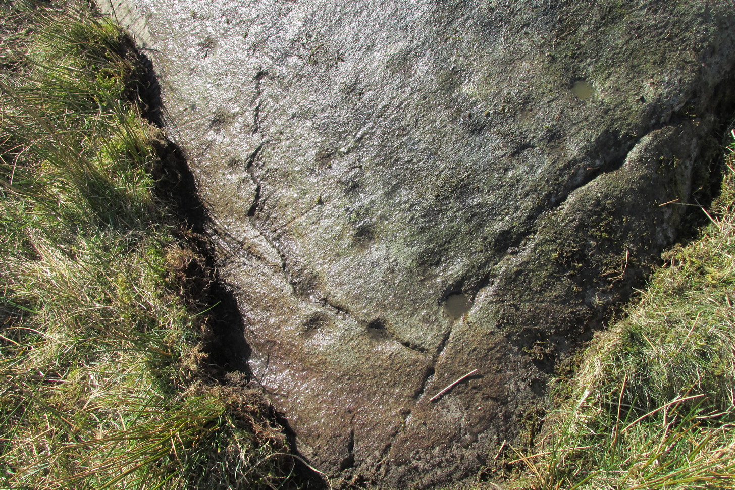
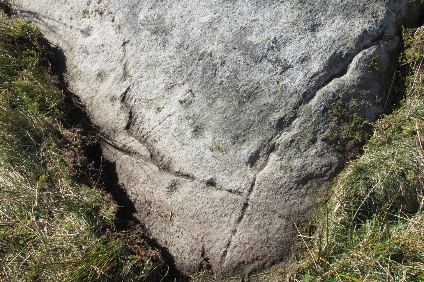
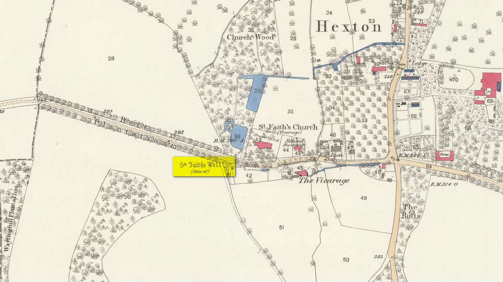
Holy Well (destroyed): OS Grid Reference – TL 10302 30328
Also Known as:
Hertfordshire Historic Environment Record No. 1926
Archaeology & History
The site of the well is now in the garden of a house on the south side of the B655 Barton Road in Hexton, south west of St Faith’s church. Prior to the Reformation, there was a small chapel of St Faith adjacent to the well containing a shrine to the saint, which was, with the well a place of pilgrimage.
N. Salmon, writing in 1728, told us:
St Faiths Well on 1882 map
“At Ravensborough, within a Quarter of a Mile, is a fine Spring, which runs down to Hexton, and meets there another Stream rising at the Berystede near the church, which is indeed a very remarkable one. It comes pouring out of the Earth in such plenty, that it would turn a Mill in a very little Way; and hath been since the Roman Times thought worthy of a Saint’s Name. It was called St Faith’s Well, to which the church also is dedicated, and the Image of St Faith was placed over it.”
The well is just to the north of the iron age hill fort of Ravensburgh and near the ancient prehistoric roadway of Icknield Way, so would certainly have been a welcome stopping point for prehistoric travellers in these chalk uplands. In line with Salmon’s contention of its having been known since Roman times, Francis Taverner, the 17th century Lord of the Manor of Hexton wrote of the well having been used for oracular purposes by people who would throw an object onto the surface of the water:
“which if swamme above they were accepted and there petition granted, but if it sinke, then rejected which the experienced Prieste had arts enove to cause to swymme or sinke according as himselfe was pleased with the partye, or rather with the offering made by the partye.”
St Faith who was a third century martyr who was beheaded at Agen in Gaul. Her saint’s day is 6th October, and her patronage was invoked inter alia by pilgrims, so the dedication of the well and nearby church may have been to ‘christianise’ a pre-existing oracular place resorted to by travellers on the Icknield Way.
Taverner again:
“There is a small parcel of ground adjoining the churchyard called “St. Ffaith’s Wick Court,” about a pole in measurement, anciently divided from Malewick by a ditch in the same place where now a large moat is made. The greatest parte of this Wick lying upon a bedde of springs, and undrained, was very boggye towards the churchyard; but the west side being higher, the ground was well planted with oaks, willows, and bushes, near adjoyning unto which, the craftye Priests had made a well about a yard deepe, and very cleere in the bottome, and curbed about, which they called St. Faith’s Well.
“Now over this well they built an howse, and in the howse they placed the image or statue of St. Faith, and a cawsey they had mad (which I found when I digged and levelled the ground) for the people to passe who resorted thither from farr and neere to visitt our Lady, and to performe their devotions reverently, kissing a fine-colloured stone placed in her toe. This Lady was trimly apparelled, and I find in an old book of churchwarden’s accounts, in the reign of Henry VIII, that they had delivered unto the St. Ffaith a cote and a velvet tippet. The Lady had no land to maintain her, that I know of, more than i acre lying in Mill Field, called at this day St. Ffaith’s acre, which, as being given to superstitious uses, came to the King’s hands at the dissolution, and is now parcel of the demesnes. The house being pulled down, and the idol cast away, the well was filled up, yet an apparent mention of the place remained till my time, and St. Ffaith’s Well continued as a waste and unprofitable and neglected piece of land till such time as the footpath was turned through the midst of it to the outside on the south by the highway, and their clearing and levelling the ground, having been drained, and sunk the spring, I converted the same, in the year of our Lord 1624, into a little orchard. The Lady Ffaith was a Virgin and Martyr of Agenne, in France, a.d. 1290.”
The well may have had healing properties too. Herbert Tompkins (1902) informed us how,
“…to folk who have never stepped out of Hertfordshire (I have known several such) the well of St. Faith is indeed the “Well at the World’s End.” The waters of that well were of miraculous efficacy, and an image of its saint was long preserved in the chapel of St. Faith Virgin, of which no stone remains.”
The parish church of Hexton remains dedicated to St Faith , as does the parish church of nearby Kelshall. There was another St Faith’s Well at Leven in East Yorkshire.
References:
Clutterbuck, Robert, History & Antiquities of the County of Hertford – volume 3, Nichols Son & Bentley: London 1827.
Farmer, David Hugh, Oxford Dictionary of Saints, Oxford University Press 1987.
Hippisley-cox, R., The Green Roads of England, 6th Edition, Methuen: London 1948.
Hope, Robert c., Legendary Lore of the Holy Wells of England, Elliot Stock: London 1893.
Johnson, Walter, Folk Memory or the Continuity of British Archaeology, Clarendon Press: Oxford 1908.
Jones-Baker, Doris, Old Hertfordshire Calendar, Phillimore: Chichester 1974.
Salmon, N., History of Hertfordshire, London, 1728.
Tompkins, Herbert W., Highways & Byways of Hertfordshire, Macmillan: London 1902.
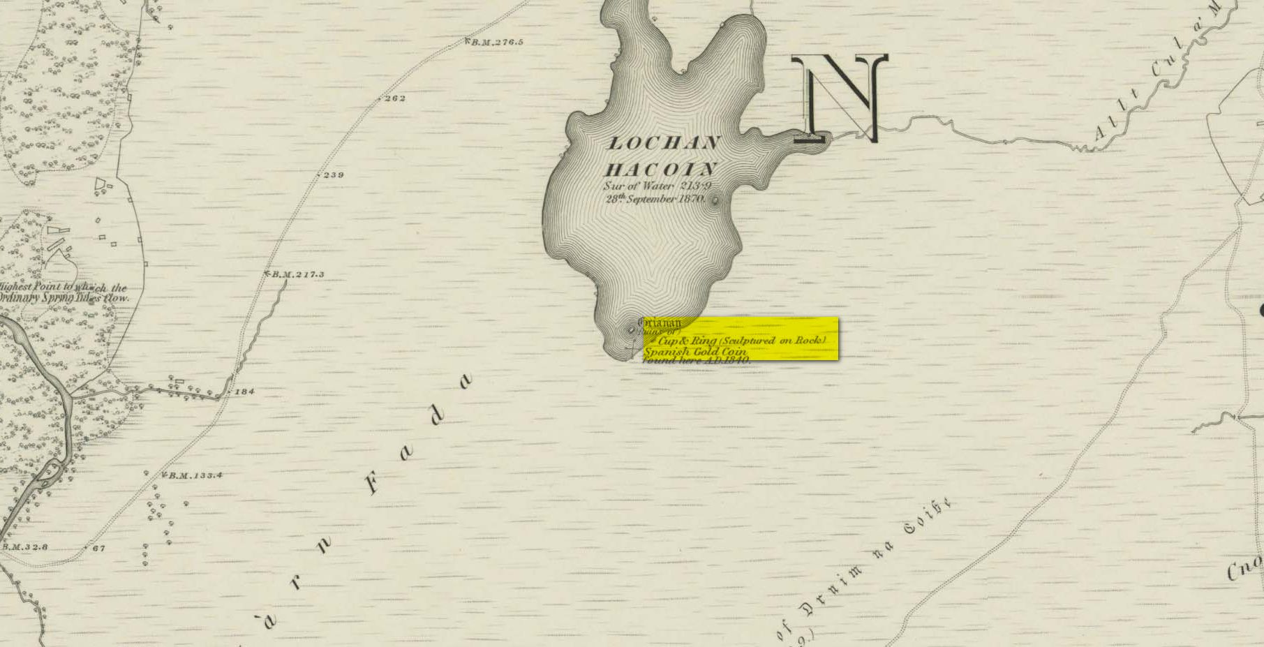
Whether you take the A836 or A838 into Tongue (through truly beautiful wilderness), make sure you go into the village itself—and then keep going, south, along the tiny country road. Nearly 2½ miles along, note the small loch of Lochan na Cuilce on your right. A few hundred yards past this, on the other side of the road (barely visible at first) is Lochan Hakel. Walk around to the south-side of the loch until you find the Lochan Hakel 1 carving. Then look up at the rock right above you. That’s the one!
Archaeology & History
In James Simpson’s (1867) primary work on British petroglyphs, he mentions this site as being in the lands of “Ribigill, near Tongue”, although it is a little further to the south. He said that a certain “Mr Mitchell” had come across it in one of his many rambles in the hills (this was probably Arthur Mitchell, author of the 1880 book, The Past in the Present). Simpson told that he had:
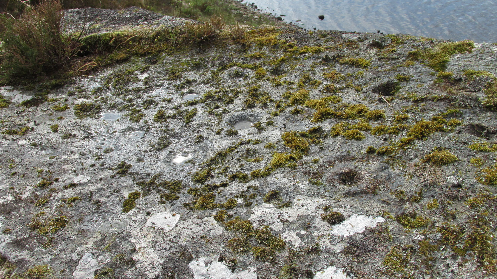
“discovered cups and circles upon a large stone, about nine feet square, apparently lying in its original position, close to the edge of a loch, which contains the remains of an old castle… The surface of the stone shows eighteen or twenty round cup excavations, about an inch deep. There is a ring of ‘hollow around each cup.'”
Although there aren’t rings around every cup, a great number of clear and impressive rings exist around many of them and are, thankfully, still reasonably visible amidst the mass of lichens.
Around the same time as Mr Simpson’s description, James Horsburgh (1868) wrote about the carving, telling us:
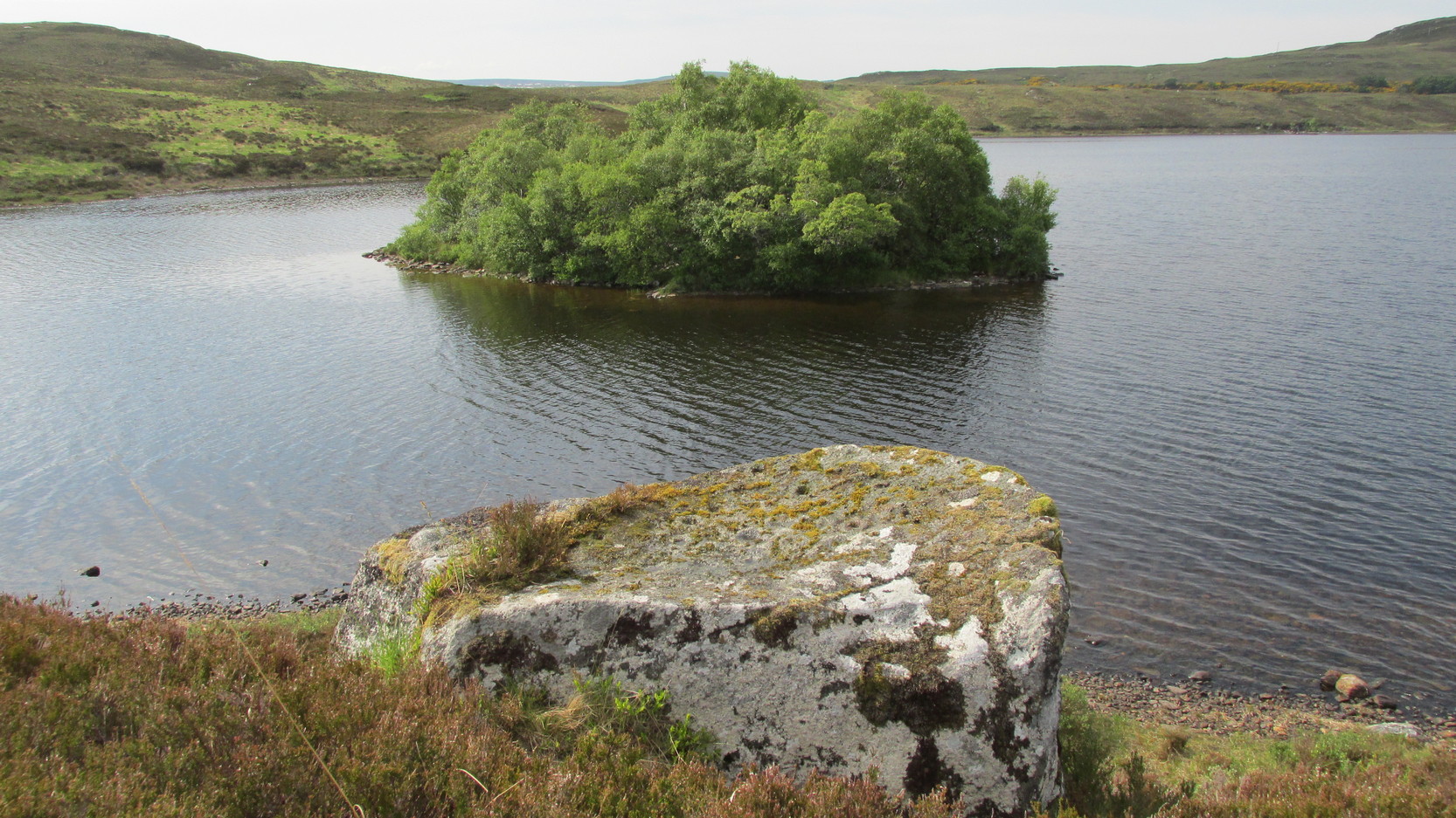
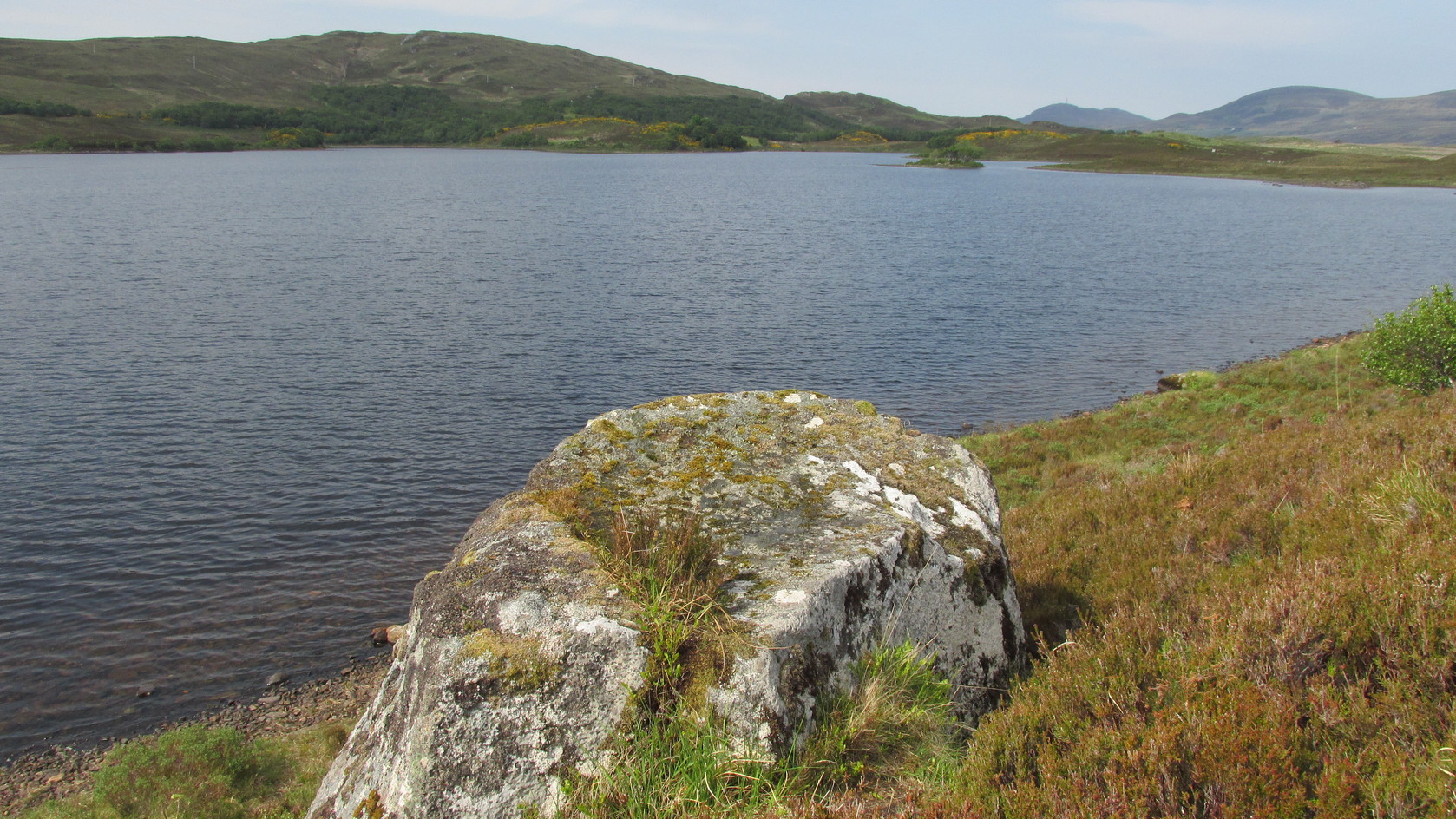
The rock and its islandSome of the cup-and-rings
“On the edge of the precipitous bank of the loch, and exactly opposite the island, there is a large boulder with a flat top, and on this there are a number of cups and rings… This stone is not generally known. Old Ross, the gamekeeper at Tongue, first told me of it, and he and I scraped off the moss and exposed the whole. He thought it was for playing some game. On the left of the stone, on a bit separated by a crack, there is a sort of a figure which appears to have been formed by cutting away the stone around it and leaving it in relief, and also some artificial cutting on the right, a sort of circular groove.”
A better description of the carving came near the beginning of the 20th century, when the Scottish Royal Commission (1911) lads included the site in their inventory. They told:
From the rock, looking NThe carving from above
“At the S end of Lochan Hacoin, to the SE of the islet on the top of the bank, is a large earth-fast boulder, on the flat upper surface of which are a number of cup and ring marks placed irregularly over it. The total number of undoubted markings is thirty-four, of which those surrounded by a ring number eleven. No cup with a double ring round it is observable. The best defined cup-mark measures 3″ across by 1¼” deep, and the enclosing ring is 7″ in diameter. Eight of the markings are well defined; the others less noticeable. At the S end there is a boss or projection, roughly rectangular, measuring 12″ x 6″. A sketch of this stone, made about the year 1866 by Mr James Horsburgh, is preserved in the library of the Society of Antiquaries of Scotland.”
Does anyone know if this drawing still exists? Anyhow, whilst you’re stood here looking at this petroglyph, don’t forget to look at the other one on the rock below you closer to the loch-side.
Folklore
In Horsburgh’s essay on the prehistoric remains of the area, he said how local people told that the cup-and-rings “were made by the high heels of a fairy who lived in the castle” on the island of Grianan, just 40 or 50 yards away.
References:
Close-Brooks, Joanna, Exploring Scotland’s Heritage: The Highlands, HMSO: Edinburgh 1995.
o’ Reilly, Kevin, What to See Around the Kyle of Tongue, privately printed 1980.
Royal Commission on Ancient & Historical Monuments & Constructions of Scotland, Inventory of Monuments and Constructions in the County of Sutherland., HMSO: Edinburgh 1911.
Simpson, James, Archaic Sculpturings of Cups, Circles, etc., Upon Stones and Rocks in Scotland, England and other Countries, Edmonston & Douglas: Edinburgh 1867.
Acknowledgments: Huge thanks to Sarah MacLean for guiding me to this carving, and also for the kind use of her photos in this site profile. Cheers Sarah! And to Donna Murray again, for putting up with me whilst in the area! Also – Huge thanks for use of the 1st edition OS-map in this site profile, Reproduced with the kind permission of the National Library of Scotland.
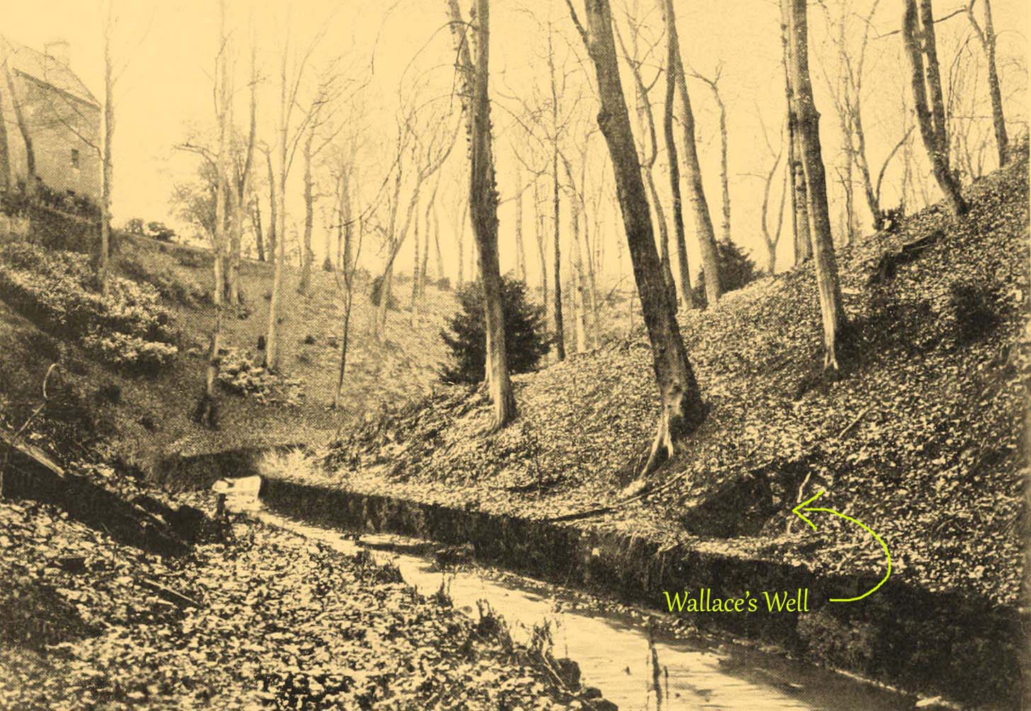
The ruins of this little-known site, dedicated to the legendary Sir William Wallace, can still be seen in the form of an overgrown stone ruin just off the footpath that runs through the Pittencrieff Glen out of the town centre. In earlier times the waters were evidently of some repute, as a Council meeting in May 1773 reported with some disdain the closure of the waters by a Mr Chalmers:
“This Day the Council considering that the entry from the Town to the Well of Spaw is now shut up by Mr. Chalmers, which was a particular privilege to ye Inhabitants of the Burgh, Do hereby appoint the Provost to intimate to Mr. Chalmers that the Town will not give up that privilege, and to require him to oppen an entry thereto as formerly.”
We don’t know whether the miserable Mr Chalmers gave access to the well, as there seem to be no Council meeting notes telling us the outcome. My guess would be that the local people got their way, hopefully at Chalmers expense! More than 70 years later, another Mr Chalmers (1844) wrote about the well in a more respectful light:
“On the north edge of the rivulet, a little below this bridge, at the foot of the Tower Hill, there is a famous well, named the Wallace Spa, or well of Spa, which was formerly much resorted to by the inhabitants of the town for its excellent water, but which has been long since disused. It is noticed here simply on account of the traditionary antiquity of its name, Sir William Wallace, it is said, having once, in the haste of a flight, drank a little of it, out of the palm of his hand.”
In spite of there being local folklore of William Wallace, the local historian Ebeneezer Henderson (1879), in his giant work on Dunfermline, thought there was a more prosaic origin to the well’s name. He told,
“This well is still in existence, about fifty yards south of the ruins of Malcolm Canmore’s Tower — Tower Hill. The water is reported as being “very cold at all times.” The water should be analysed. The well during the period of its being used was known as the “Spaw Well,” and the ” Well of Spaw,” and, by and by an easy, natural transition, ” Wallace Spa;” and thus the name of the well has sometime been connected with that of the great Scottish hero.”
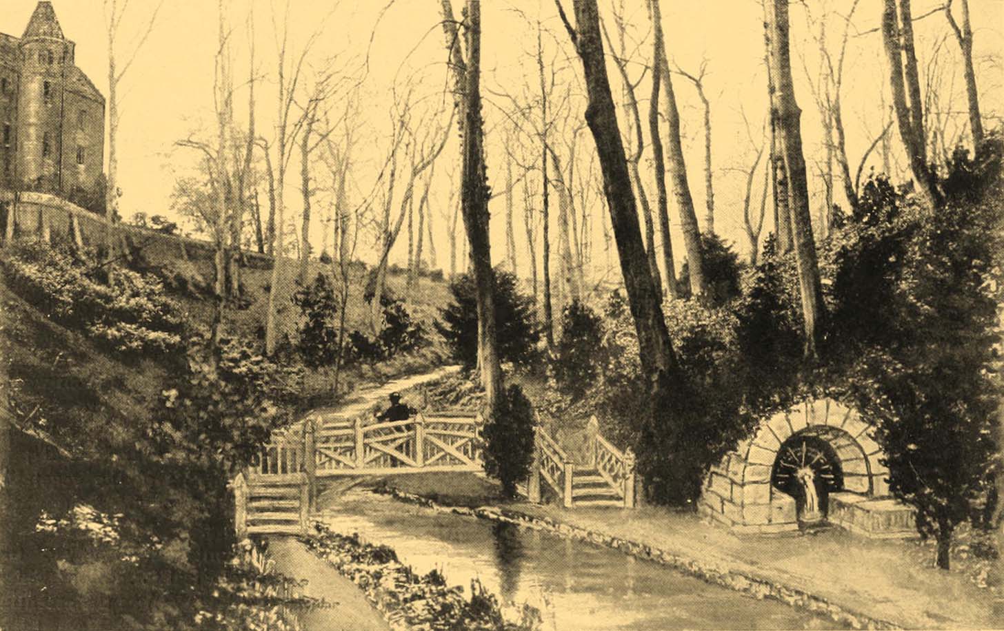
The Well after 1900pre-1900 image
By the end of the 19th century, the well had become almost buried by earth and foliage, but was subsequently brought back to life following architectural improvements of the glen around the turn of the 20th century. In Patrick Geddes’ (1904) work he gives us “before and after” portraits (attached here) showing how it had been restored. He also mentioned “its tradition of medicinal value”, but could give no further information regardings the ailments it was reputed to cure…
References:
Chalmers, Peter, Historical and Statistical Account of Dunfermline, William Blackwood: Edinburgh 1844.
Tumulus (destroyed): OS Grid Reference – TQ 222 709
Archaeology & History
It seems that a great number of prehistoric remains used to exist in and around the Wimbledon Common area. This one is mentioned only briefly in Thomas Stackhouse’s (1833) rare work on early British remains, where he wrote:
“Near an old single-trenched Camp at the South West comer of Wimbledon Common, is a very small flat Barrow cut into the form of a cross: I don’t know that it has been noticed by any writer.”
The “single-trenched Camp” he described is today known as Caesar’s Camp hillfort. By the time the Wimbledon historian William Bartlett (1865) came to write his survey, the site had been destroyed. In Mr Johnson’s (1903) survey, he seems to confuse this site with the large barrow cemetery that used to exist on the northern edges of Wimbledon Common described by William Stukeley and others.
(the grid-reference to this site is an approximation).
References:
Bartlett, William A., The History and Antiquities of Wimbledon, Surrey, J. & S. Richards: Wimbledon 1865.
Johnson, Walter, Neolithic Man in North-East Surrey, Elliot Stock: London 1903.
Long since gone, this great olde ash tree could once be found on the south side of Killin’s Mill building, close to the bridge at the Falls of Dochart. It was deemed to be ‘sacred’ by local people – just as all trees were, once upon a long time ago.
In John Shearer’s (1883) wonderful book on the ancient ways of the Perthshire people, he described the tree as being adjacent to the earthfast rock known as St. Fillan’s Seat:
“At the side of it grows a large ash tree which is held sacred by the natives as no person will burn any of the branches although fallen to the ground nor destroy them in any manner. However, there was one who had the hardihood to take one of the branches for a caber to repair his house. Strange to tell the first fire that was kindled burned it to the ground as a punishment for this impious sacrilege. Of course no person since has troubled it or taken any of the wood. The branches that fall lie till they rot.”
The brilliant Killin historian, W.G. Gillies (1938) reported that the tree was still standing until it was “blown down by a gale in 1893″—but it didn’t quite kill it off for good; for in September 1911, C.G. Cash visited Killin and this was one of the many places he looked for and, despite local folk telling him about the more famous St Fillan Stones (still in existence and found at the Mill), he saw the last remnants of this great Ash, telling simply that,
“the mere dead stump of St Fillan’s Ash-tree still stands against the south post of the mill gate. And quite near it is a young ash, said to be its descendant. This younger tree has an out-curving branch that was said to have been the gallows-branch in olden days; but it is obviously too young and too weak.”
…So, does anyone know precisely which is the “descendant” of St. Fillan’s Ash and where happens it to be growing?
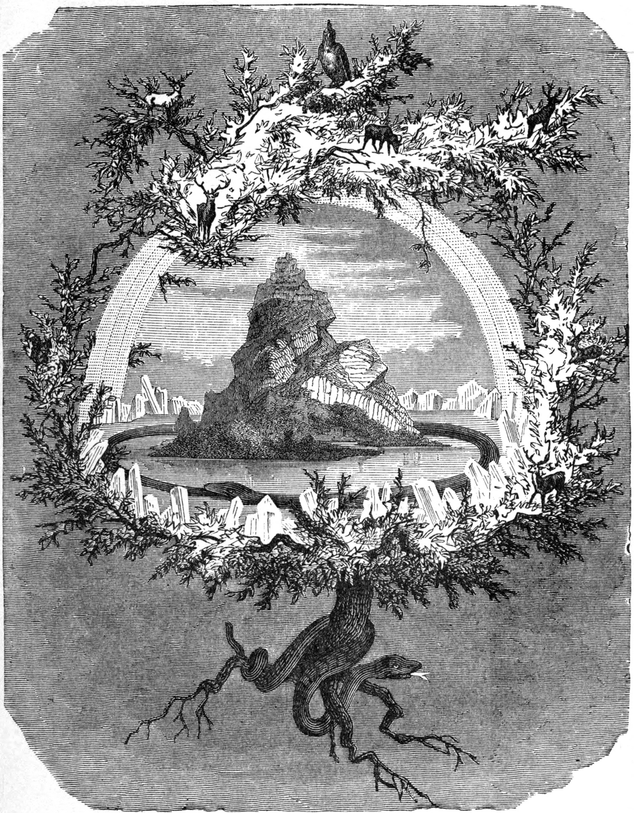
In Norse myth, the ash tree Yggdrasil was the tree of Odin and was one of the primal ingredients in their Creation myths. It stood at the centre of the cosmos: an axis mundi no less, linking the many worlds and was the abode of the gods. Its mythologies are extensive. In Scotland, the myths of the ash are not so well known, but there’s little doubt that it possessed a sanctity and certainly has many traditions of it own, which are unfortunately outside the remit of this site profile.
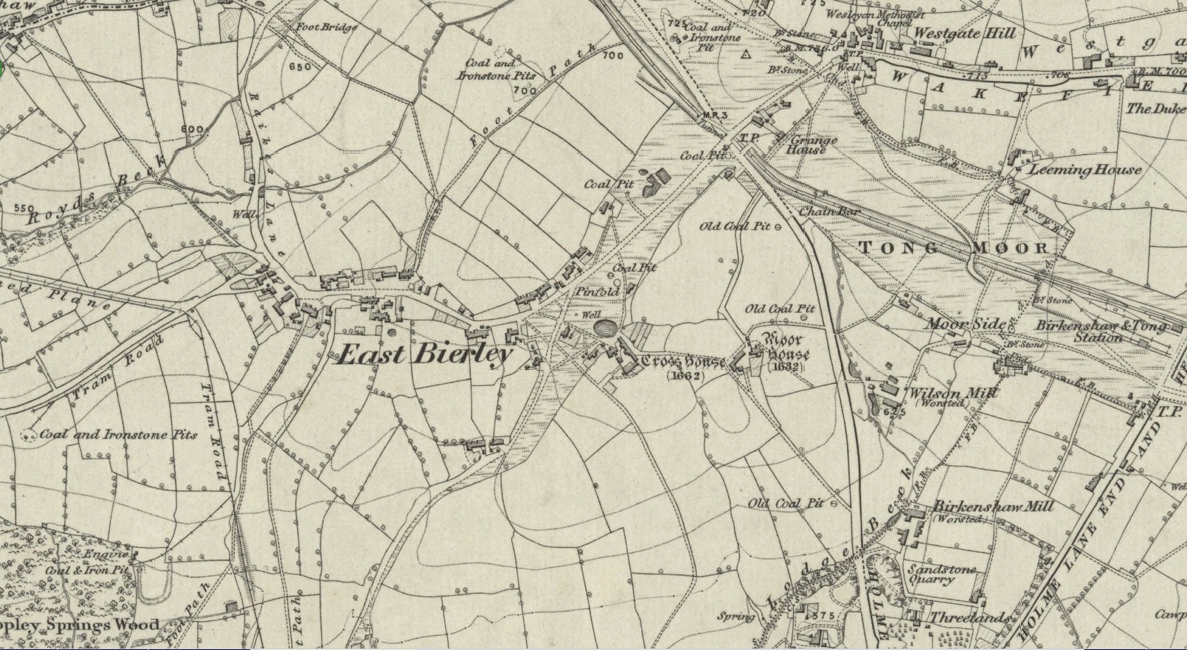
Crosses / Legendary Rocks (destroyed): OS Grid Reference – SE 1975 2909
Archaeology & History
Site location at Cross House
Not to be confused with a much more renowned namesake above Ilkley, this was the name given to two old stones that once existed in the middle of the East Bierley hamlet (as it was then) southeast of Bradford. They were two large boulders next to each other, not far from the early farmstead of Cross House (see map, right) and were described in James Parker’s (1904) historic collage of the area, where he informed us that:
“On the village green (are) the primitive large stones locally called the “Cow and Calf stones,” which used to be in days gone by a Preaching Cross and Market Cross.”
When William Cudworth (1876) described the place nearly thirty years prior, he only mentioned a single cross, telling us:
“There is a lane which has long been called Kirkgate at Birkenshaw, leading up to an ancient cross on the hill. The fact of this cross being on the hill must have given rise to the name Kirk (church) gate, as there was not, until a few years ago, any church at Birkenshaw. In a previous paper we had occasion to notice the existence of the cross as an evidence of a pre-church period.”
The meaning behind the name Cow & Calf is unexplained by our respective authors, although Cudworth’s citation of “the cross as an evidence of a pre-church period” is probably not without merit here. It seems very likely that the animal names of the two large stones—akin to the Cow & Calf Rocks at Ilkley and others of the same name elsewhere in the country—that sat near the top of the hill, probably possessed a creation myth similar to others of the same name. From this, it seems logical that local folk held the rocks as important, which would have obviously attracted the regressive attention of Church—so they stuck a cross here to christianize the place and in doing so ensured that local people could continue using the place as a meeting place. This practice (as if you didn’t already know) was widespread.
Although Mr Cudworth seems to give the first real account of the place, field-name records of 1567 listed a ‘Cowrosse’, which may have been the “cross on the Cow” stone. A.H. Smith (1961) listed the site and suggested the element –rosse may derive from a local dialect word meaning a marsh, but a ‘cow’s marsh‘ seems a little odd. It is perhaps just as likely that an error was made in the writing of rosse instead of crosse.
References:
Cudworth, William, Round about Bradford, Thomas Brear: Bradford 1876.
Parker, James, Illustrated History from Hipperholme to Tong, Percy Lund: Bradford 1904.
Smith, A.H., The Place-Names of the West Riding of Yorkshire – volume 3, Cambridge University Press 1961.
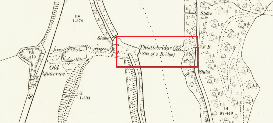
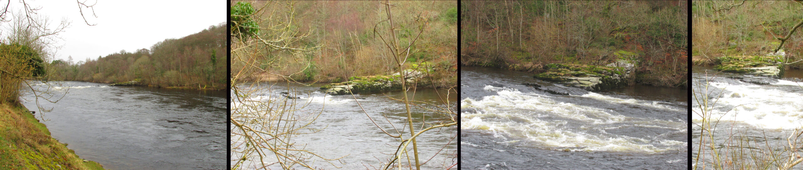
The easiest way to see the site is to stop at the car park at Craighall on the B9099 south of Stanley, and follow the path to the river. The remains of the Brig will be seen on the other side of the Tay from the riverside walk.
Archaeology & History
The Thistle Brig was described in the nineteenth century Ordnance Survey Name Book as:-
‘A remarkable spot in the River Tay, when the breadth of the river becomes suddenly narrow by the protrusion of a bed of trap rock which crosses it at this place.’
Thistle Brig & the quarries for its hard stone on the 1901 25 in OS-map
According to local historian Alexander Scott, the Thistle Brig formed a convenient place to ford the Tay until much of it was blasted away by explosives some time in the mid-nineteenth century in order to improve the flow of the river. Old maps imply that an actual bridge may have spanned the Tay hereabouts at some time in the past. The seemingly little known folklore of this site relates to an invasion by the Danes in the early mediaeval period. Elsewhere there are similar stories, so the truth or otherwise depends on where you are in Scotland, but this one may have more validity as the tale seems to give its name to the place!
The name ‘Thistle Bridge’ has been applied on old postcards to a stone footbridge over a side channel or lade between the road and the River Tay to the south of the Brig, and is not the subject of this profile.
The remains of the Thistle Brig – a hard basalt dyke on the east bank of the River Tay
Folklore
Alexander Scott, writing of the Brig:-
“…tradition holds that here the thistle received the distinction of becoming the national emblem of Scotland. In one of the many invasions the country suffered from foreign armies, the Danes, on one occasion, having landed on the east coast sacked the town of Montrose and continued on their march across the country, burning and pillaging as they went. While crossing the Tay at this ford at night, the incident occurred of one of the leading soldiers arriving on the opposite side suddenly coming in contact with a thistle with his bare leg, which caused him to emit a shreik of pain.
“The noise was heard by the Scots, who had been encamped nearby, and the alarm thus given was the means of securing a victory over their enemies. The thistle was thereafter honoured as the national badge.”
Reference:
Scott, Alexander, St Martins and Cambusmichael, A Parochial Retrospect, Munro & Scott 1911.
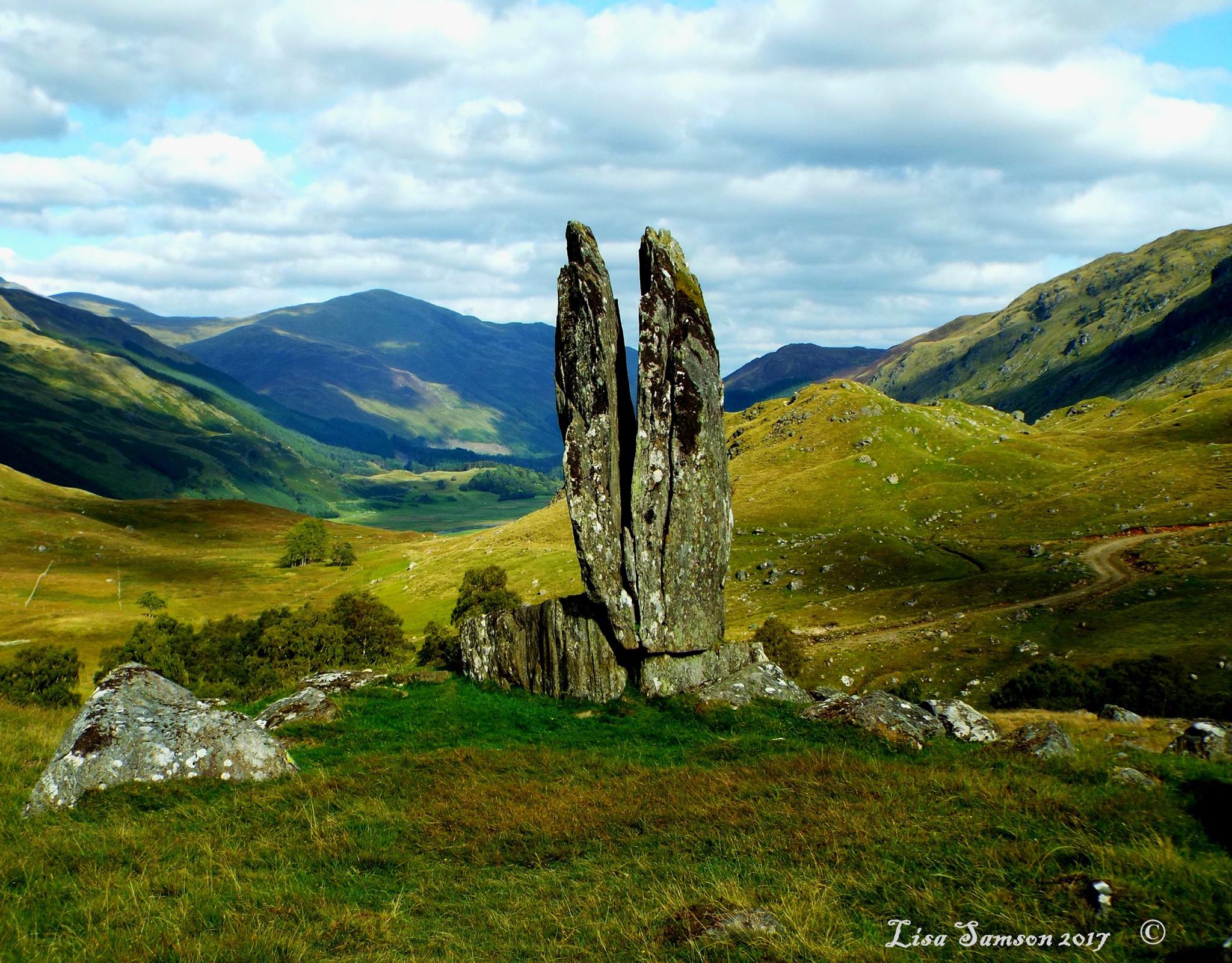
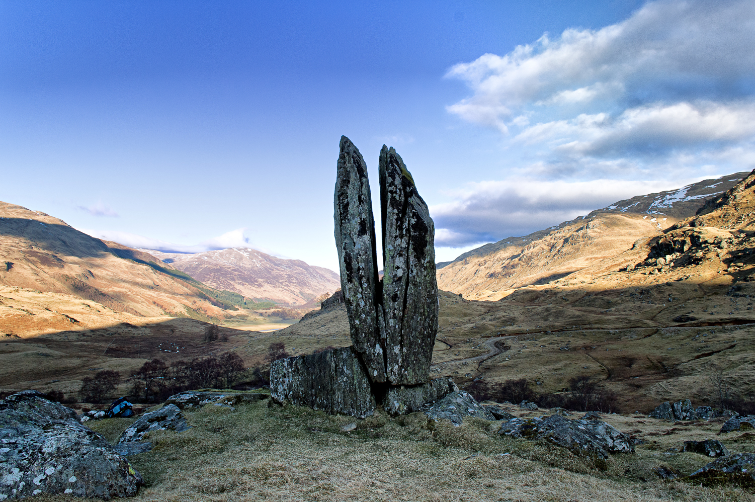
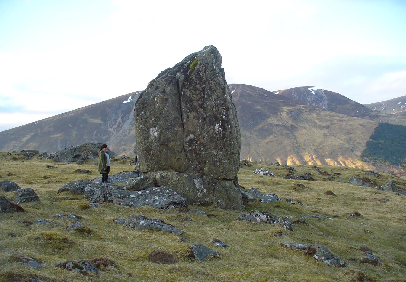
Clach na Sgoltadh, Glen Lyon (photo – Lisa Samson)
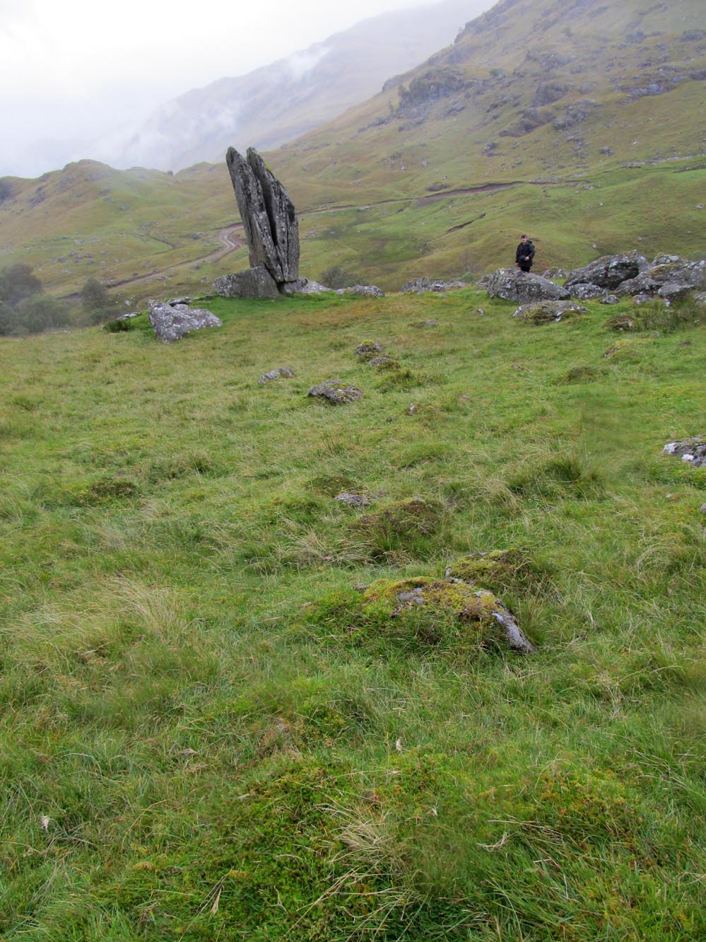
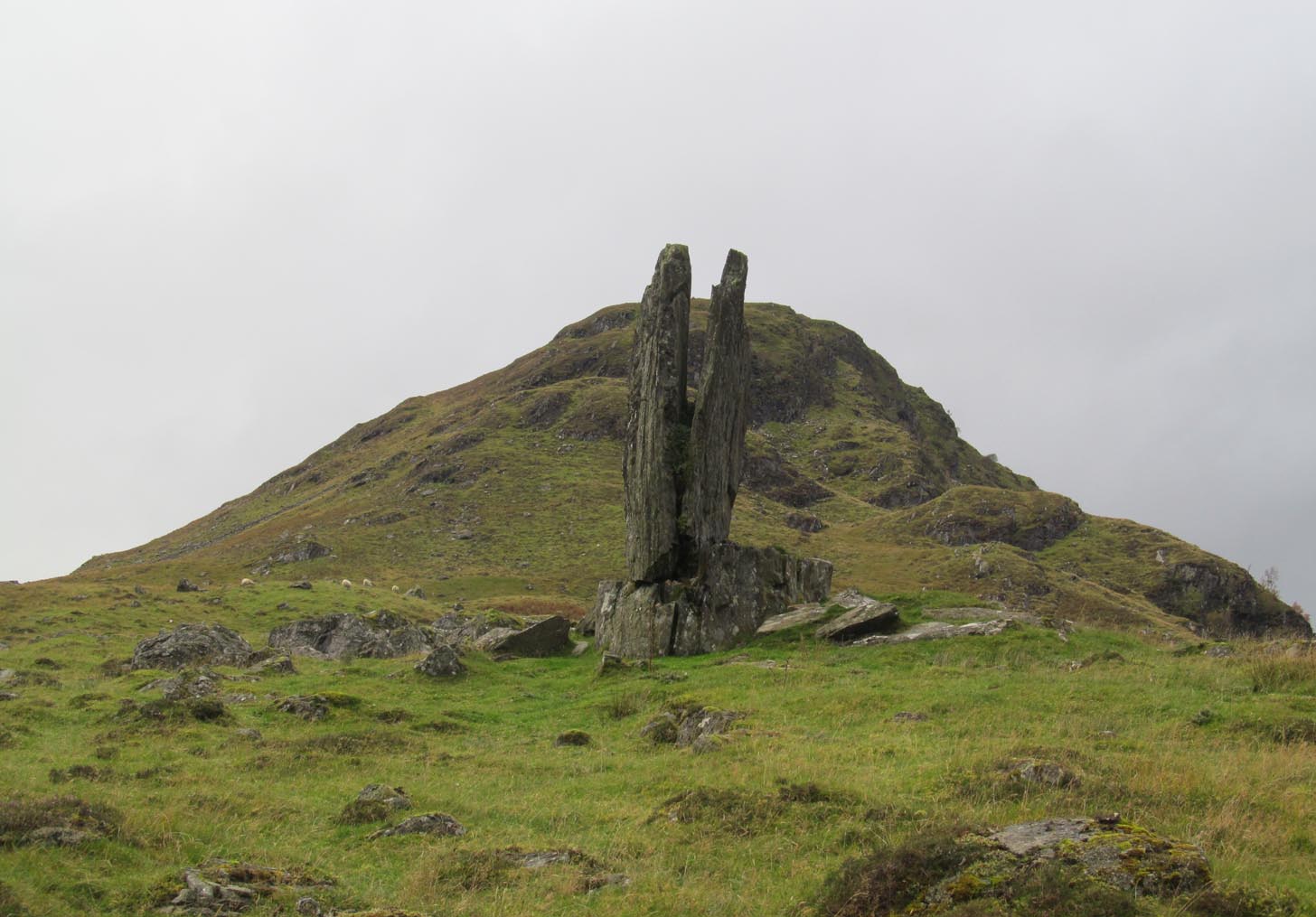
From Fortingall take the road into the legendary Glen Lyon. About 8 miles along, a short distance past the Adamnan’s Cross standing stone, you reach the tiny hamlet of Camusvrachan. On your left is a singular dirt-track, past some cottages. Go along here and over the river bridge until you reach the junction on the other side. From here, turn right and a half-mile on when you reach the farm and manor-house on your right, park up. From here you’ll see a track going uphill. Walk straight up and after a half-mile or so, keep your eyes peeled to your right. You cannot fail to see this impressive giant on the slopes above you!
Archaeology & History
This is a truly mighty monolith! — a beauty no less! Standing upon a rocky ridge nearly halfway along the glen, the landscape it looks across is, without doubt, some of the finest in the British Isles. To our ancestors who, until just two hundred years ago peopled this and nearby glens in great numbers, this great stone would have been well known and had old myths told of it. Today we have only bare fragments.
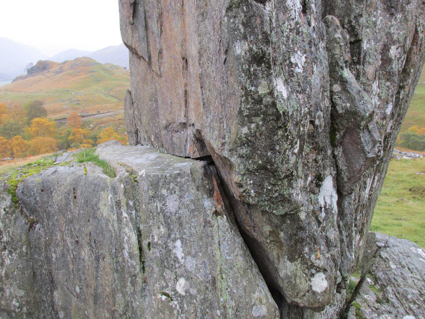
To give an ‘archaeological survey’ of any kind to this site would seem somewhat of an anathema, as it is generally deemed to be little other than one of Nature’s incredible creations. We’ll come to that in a minute. But what is quite certain is that a line of very old and very low-lying walling runs from up the slope and almost straight down to Clach na Sgoltadh. You can see it pretty clearly in the photograph below. The walling stops at the giant stone and continues no further downhill from the other side of the giant upright.
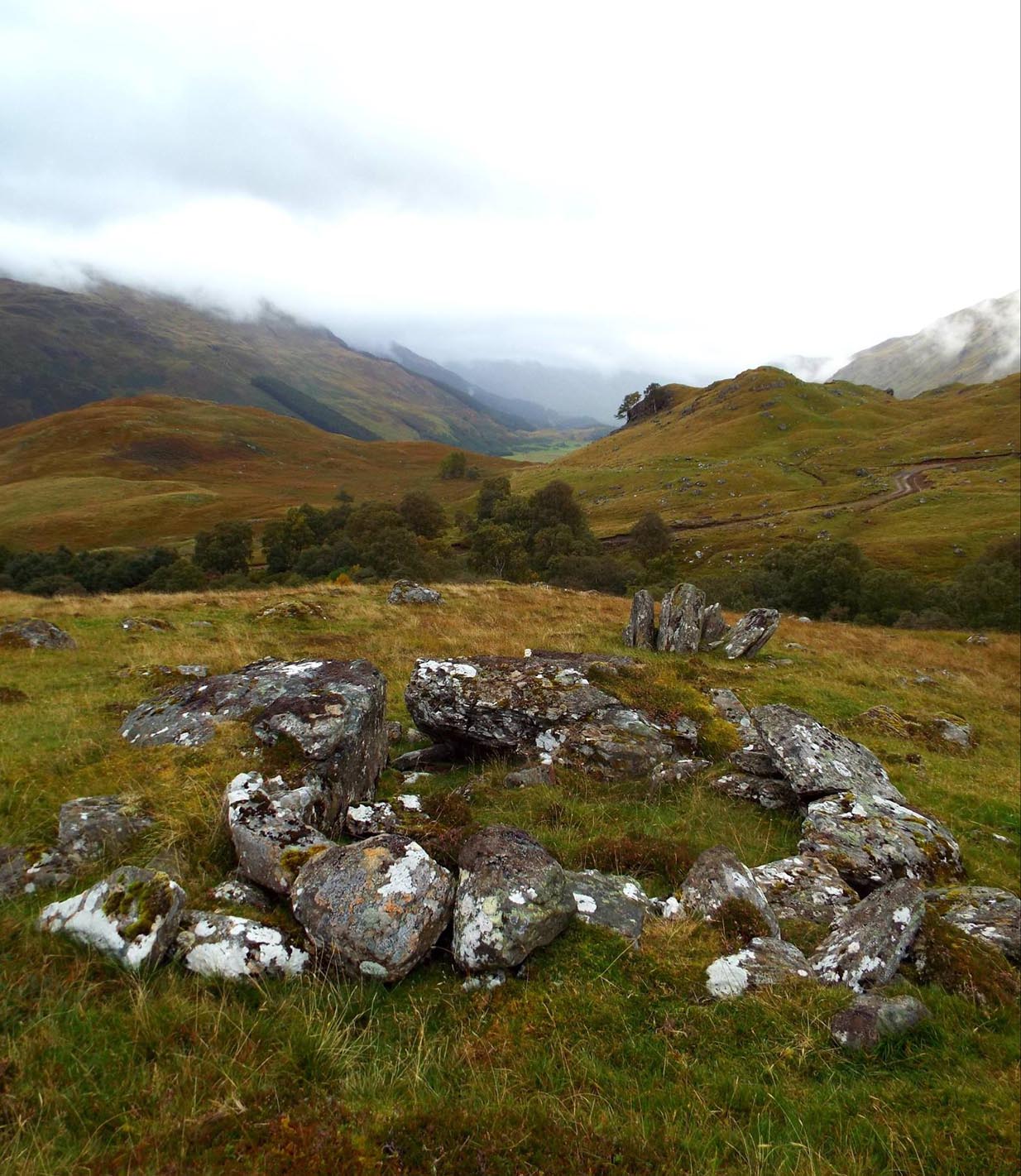
Walk diagonally down the slope about 30 yards south-east from the stone and you’ll find a small but distinctly man-made ring of stones, low to the ground, with an entrance on its northeastern side. It’s somewhat of a puzzle as it’s too small for a hut circle (I laid down in it in various ways and found you’d have to lie foetal all night if you were to use it as your own little abode), and it equally too small as an animal pen – unless it was for just one animal, which is most unlikely. The small circular construction wouldn’t seem to be prehistoric, but it would be good to know what it is.
So, we do have some very slight archaeological association with the site, albeit minimal, with the very ancient walling that leads to the stone being the most intriguing.
Small stone ‘hut’Low line of walling
The stone is generally attributed to be a geological creation. I certainly cannot say, as I have no expertise in the subject. However, in the opinion of just about everyone with whom I’ve visited this stone, I seem to be the only one who doesn’t think it’s man-made. A number of people have each insisted to me that it’s been stood upright by humans due to the quite distinct ‘squaring’ of the upright stone, particularly at the north-facing base. —and been seemingly bemused at my own lack of conviction. It does look as if it could have been cut and squared just as they all say but, let me repeat, I’m no expert at geology, and so all I can say is that I simply don’t know one way or the other. (useless prick that I am!)
“Perhaps a stone mason might know?” someone suggested—which seemed to be a good idea. Certainly a stone mason would surely be able to tell if it had been cut and dressed at the base, where it fits into the large earthfast rock….
Cue Chris Swales: a reputable stone mason from near Skipton, North Yorkshire. Chris and his friends took a week long whistle-stop tour in and around the Loch Tay region and thought they’d visit Glen Lyon. I heard about this and so asked him if he’d have the time to visit this stone giant and, if possible, let us know his opinion: is is a natural obelisk, or does it look to have been erected by humans? I told him my opinion and that of the geologists who give it an entirely natural provenance.
It was a few weeks later when he got back in touch and I asked him if he’d been up to Clach na Sgoltadh.
“I did,” he said. “it’s bloody impressive Paul. And what a gorgeous landscape too. I’d love to go there again.”
“Aye, it is Chris. And what did you think of the giant stone then? In your opinion is it man-made or natural?”
“Well I don’t know for certain Paul,” he said, “but in my opinion I’m 95% sure that it’s man-made.” He said it plain as day, just like a typical daan-to-Earth Yorkshireman. Chris isn’t into any the energy ley-line stuff, so his words carry more weight than those who wanna spice-up a site by projecting their own beliefs onto a place. As a result, I was somewhat taken aback by his words.
“What—are you sure Chris?!” I asked.
Cut & dressed stone?
“Like I said – I’m not 100% sure Paul. I can’t really say it 100% – but I’m 95% certain that people cut and dressed the base of that stone and put it there. If it’s natural, then I’d like to know how they think that’s the case. I’m willing to be shown otherwise, but in my opinion, on the whole, it’s man-made. People stuck that stone there!”
It would be great to get another stone mason’s opinion about this site; and it would definitely be good to read a geological viewpoint, but I’m not aware of any papers regarding this stone. (does anyone know of any?) For my part: I can only reiterate that I’m ‘unsure’ whether or not this is man-made. I’m simply not qualified to give an objective opinion.
The curious thing is: if this isNature’s handiwork, then it would have been held in greater reverence to our ancestors than if it had been erected by people. Impressive creations of Nature were always deemed to be inhabited by genius loci of truly archaic potency. And in these deep impressive mountains, where the names of nature spirits still abound, this—without doubt!—would have been a place of considerable awe and sanctity. May it remain as such…
Folklore
Looking to the west immediately uphill and behind Clach na Sgoltadh is the rising rounded hill of Creag nan Eildeag. Legend has it that the great Celtic hero Fionn stood atop of this crag and fired one of his arrows at the stone, splitting it in half and leaving the stone as we see it today.
In a small cleft in the stone, quartz deposits can be seen along with an effigy of the Virgin Mary. However, the title of the Praying Hands of Mary is a modern attribution and has no historical or mythic veracity.
References:
Stewart, Alexander, A Highland Parish; or, The History of Fortingall, Alex MacLaren: Glasgow 1928.
The site of the well, which was in the historic county of Middlesex, appears to have been on the west side of the present Moorefields Road just north of the junction with St Loy’s Road. The OS reference is an approximation. The restored circular well house to the south of the High Cross at the High Road – Philip Lane junction now popularly known as ‘The Old Well’ or ‘The Old Pump’ by Tottanham Green has been referred to as being ‘St Eloy’s Well’ but this is not the historic well described in this profile.
Archaeology & History
Likely position of the well on the 1873 6″ OS Map
The well was still in existence in 1876, but by the time of the revision of the OS map around 1894, it had been destroyed following building of the Great Eastern Railway’s Enfield branch line and the construction of terraced housing along the new St Loy’s Road.
So where was the well? The 1873 6″ OS map shows a field on parts of which the railway line and St Loy’s Road are now built, and a small area of water is shown in this field which is the likely position of St Loy’s Well on the eve of its destruction, when it was described as a dirty pool of water full of mud and rubbish. If this was the position of the well then it has now been completely built over…
It was described by Robinson in his 1841 History of Tottenham as being:
‘..in a field….on the western side of the High Road…surrounded by willows…it is bricked up on all sides, square and about 4 feet deep..’ ‘ In Bedwell’s time [it was]…always full of water, but never running over; the water of which is said to exceed all other near it.’.. ‘the properties of the water are similar to the water of the Cheltenham springs’.
Thomas Clay ‘s 1619 map of Tottenham, illustrated in Robinson’s book shows a field north west of Tottenham High Cross called ‘Southfeide at St Loys’. The Tottenham historian Wilhelm Bedwell described the well in 1631 as:
‘“nothing else but a deep pit in the highway, on the west side thereof;”….”it was within memory cleaned out, and at the bottom was found a fair great stone, which had certain letters or characters on it; but being broken or defaced by the negligence of the workmen, and nobody near that regarded such things, it was not known what they were or meant.’
This fair great stone with its ‘certain letters or characters that no one knew what they were or meant’ is intriguing especially in view of the well’s proximity to the Roman Ermine Street (Now the High Street). Were those mysterious characters spelling out an undecipherable Latin inscription on a Roman stone? We shall never know, but it hints at a pre-Christian origin or veneration of the well. Another hint is that before the Reformation there was nearby a chapel of St Eloy known as the Offertory*, which may have been originally built to ‘Christianise’ a pre-existing heathen sacred spring. The Roman origins of the well are also hinted at (probably erroneously) by W.L. Bowles in 1830, writing of a ‘Druidical Tour’ that one Sir Thomas Phillipps undertook on the continent, first quoting Phillipps before adding his own conclusion:
‘“Near Arras in France, are found the mount of St. Eloi and the very name of a place, Tote. I have no doubt Druidical remains will be found there, if this be not the very country of Carnutes.”
Now let me observe, that Tote is Taute —Tot—Thoth, latinized into Tewtates by Lucan, &c. the chief deity of the Celts. St. Eloi is neither more nor less than the Celtic word Sul, turned into the Greek the Sun; and Elios, turned into the Catholic St. Eloi, as at Tottenham, Middlesex, anciently Tote-ham, the ham of Taute or Tent, where is also the sacred well of St. Eloi, or ‘Helios’, the Sun !’
Saint Eloi / Eloy /Loy / Eligius, is the patron saint of those who work in the alchemists’ metal of the sun – goldsmiths! He is also the patron saint of blacksmiths, farriers, and all who earned their livings from horses, and lived from around 588 to 660 to become Bishop of Noyon and the evangelising apostle for much of modern day Belgium. His feast day is 1st December, and he had a widespread cult in mediaeval Europe, including England. In addition to being a healing well for humans, one writer hints that the well’s waters may have been employed for healing horses…they certainly would have drunk from it with its proximity to what is now the High Street.
Around 1770, an artist called Townsend (the sources are unsure as whether it was a Mrs or Mr) produced a romanticised drawing of the well, which was exhibited at the Royal Academy in 1770-1. It depicts a hermit beside the well (the Hermitage of St Anne stood to the south of High Cross prior to the Reformation) receiving an offering from a lady. It was engraved and sold as a print, and may be the only image of the well before its demise.
Folklore
In 1819 – 20, John Abraham Heraud wrote a poem about St Loy’s Well, set in the time of St. Edward the Martyr, (the late 970s), entitled ‘ Stanzas in the Legend of St Loy‘ of which the most relevant verses are;
‘TOTEHAM! the Legend of thine olden day, To the last note hath on thine echoes died; But the Bard’s soul still lingers o’er the lay, To muse upon thy transitory pride The pride of times that hath been — blank and void— When all was Nature, big with many a song Of Chivalry and Fame, with Love allied— But Time both changed the scene — now houses throng Where once was solitude — and people crowd along.
Where now thy WOOD, that spread its misty shade O’er twice two hundred acres? — past away! And vain its PROVERB, as the things that fade, Earth, sun, moon, stars, that change as they decay! The lonely CELL, the tenor of the lay, Its grove, which hermit tendance loved to rear; And, St. LOY, mouldering to Time’s gradual sway, Thy rites, thy OFFERTORY disappear;— Forgot thy SPRING OF HEALTH no votary worships there!
Forgot, neglected — still my harp shall dwell On thee, thou blest BETHESDA of ST. LOY! As Fancy muses o’er the vital WELL On years of storied yore, with grief and joy, Exults they were — weeps Truth should e’er destroy! Thrice I invoke the Spirit of the Stream With charm she may not question, or deny, And, like a Naiad, o’er the watery gleam She rises to my voice, and answers thus the theme:— ‘
Heraud wrote a further poem mentioning the well, his ‘Tottenham‘ of 1820, the relevant verse being:
‘St. Loy! here is this fountain—emblem pure Of chaste unostentatious charity— Never in vain intreated, ever sure ; Yet o’er the marge thy waters fair and free Ascend not, overflowing vauntingly, But in thy bounty humble as unfailing, In grief, disease, and sickness, visit thee. But part in joy, changed by thy holy healing To manhood, strength, and life, thy far renown revealing. There is thy offertory, and thy shrine, Simple, inartificial ; nor of fame, Nor any honour, save that it is thine, And all its glory centres in thy name !’
*Footnote – Brian Spencer’s book on mediaeval pigrim badges recovered by archaeologists in London refers (p222) to a distinct ‘London pattern’ of St Eloi badge – is this a hint that the Offertory was a local shrine to St Eloi where such badges were sold to pilgrims? Further research is needed to try to verify this speculation.