Pretty easy really. From the town centre, head up the B6143 Oakworth Road for barely 100 yards then turn right up the long steep West Lane. Just keep going. Near the very top turn sharp right onto Shann Lane. And there, on the left-hand side of the road, right next to the solitary old-looking house just 100 yards along, is our little well! (if you end up with fields either side of you, breaking into hills, you’ve gone too far)
Archaeology & History
Jennet’s Well, Black Hill, Keighley (middle of the picture, next to house)
The history of this site is very scant. It was written about by local historian William Keighley (1858) as a holy well dedicated to an obscure saint, St. Jennet, although early place-name evidences don’t tell as much. Some have even suggested that the same ‘Jennet’ was the tutelary saint of Keighley and district itself. Local historian Ian Dewhirst (1974), writing about the town’s local water supply, thought that “water from a spring ‘a mile to the west’ above the town…was conveyed by stone troughs through the chief street for the convenience of house-holders,” was probably Jennet’s Well.
Folklore
Described by Will Keighley (1858) as having “great healing abilities,” its specifics were undefined. And when the great Yorkshire writer Harry Speight (1898) came here forty years later, he told of the site “having a great repute, though no one seems to know why.” Mr Keighley was of the opinion that Jennet’s Well may have been the christianized site which overcame the local people’s earlier preference of dedication at the True Well, more than a mile west of here, between the gorgeous hamlets of Newsholme and Goose Eye; but this would seem unlikely, if only by distance alone.
The name ‘Jennet’ itself initially seemed somewhat obscure. It is not recognised by the Catholic Church as a patron saint. The word could be a corruption of the personal name Jenny, perhaps being the name of a lady who once lived hereby. There’s also the possibility that the title may infer the well’s dedication to the bird – a not uncommon practice. And we also have the modern folklorists who could ascribe it to the fairy-folk, as Jennet and Jenny are common fairy names, and old wells have much lore linking the two. But as Michala Potts pointed out, bringing us back to Earth once again, a ‘jennet’ is an old dialect word for a mule. I rushed for my Yorkshire dialect works and, just as Mikki said, the old writer John Wilkinson (1924) told simply, ‘Jennet – a mule.’
References:
Dewhirst, Ian, A History of Keighley, Keighley Corporation 1974.
Keighley, William, Keighley, Past and Present, Arthur Hall: Keighley 1858.
Speight, Harry, Chronicles and Stories of Bingleyand District, Elliott Stock: London 1898.
Wilkinson, John H., Leeds Dialect Glossary and Lore, James Miles: Leeds 1924.
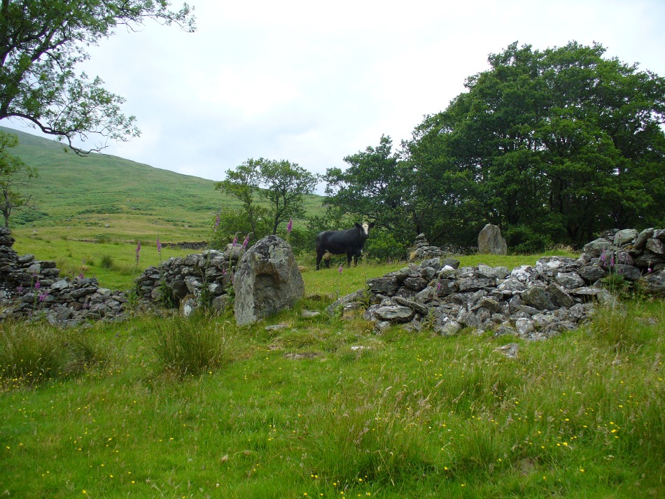
From Killin, travel down Glen Lochay, past Stag Cottage or Duncroisk and over the shallow river of Allt Dhun Croisg. If you’re in a car you can park up a 100 yards past the river bridge and walk up the track from here. After a 10 minute walk, above the trees you come to the derelict village of Tirai* where, until recently, you were greeted by a tall totem-pole of a gnarled tree (it was superb!) which is now Earth-lain, and a fine view of the evolving hills. Here amidst the ruins we also find a standing stone or two.
Archaeology & History
The village of Tirai was deserted sometime in the 19th century (due to the disgusting clearances of the English), but at least two standing stones still live amidst its ruins. The tallest is nearly four-feet tall in the middle of the grassy patch and is much used by grateful cattle to rub themselves against when midges and horseflies drive them mad! The Scottish Royal Commission lads reckon the megaliths here are,
“possibly a survivor of a stone circle as a similar stone is used nearby as a gate-post to an enclosure and several other large stones have been incorporated in the walls of the surrounding buildings.”
This may well be so – but it is equally possible that these are merely the remains of standing stones which once stood along this ridge and which were taken for use in the village.
One of the Tirai standing stones
Of the remaining standing stones in this idyllic setting – the Royal Commission fellas counted possibly four of ’em – all are roughly the same size, between 3 and 4 feet high. Johnstone & Wood (1996) also think the stones here may once have related to a prehistoric cairn in the village.
This is an utterly beautiful arena, even in the heights of winter. The village sits on the rear slopes behind the old cailleach, and there are plenty of cup-and-ring carvings, both known and unknown scattering the rocks and nearby hills. The curious Duncroisk Crosses carving is just visible from here, on the other side of the rocky gorge. Lost tales and lost sites abound here also. I did sit and wonder though… Considering that the villagers here left the old standing stones in place until very recent centuries at the heart of their hamlet, what uses did they make of it, or what tales did it speak? Or had the purge of the Church already taken its toll…?
References:
Gillies, William A., In Famed Breadalbane, Munro Press: Perth 1938.
Johnstone, A.S.K. & Wood, J.S., ‘An Archaeological Field Survey of Deserted Townships at Tirai, Glen Lochay, Killin,’ Association of Certificated Field Archaeologists (Glasgow University) Occasional Paper no 9 (1996).
* The place-name Tirai means ‘land of good luck or joy,’ which truly speaks well of its spirit and setting to me.
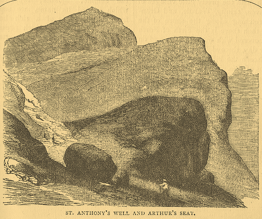
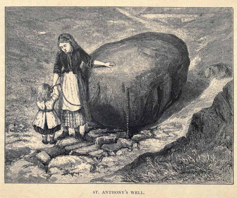
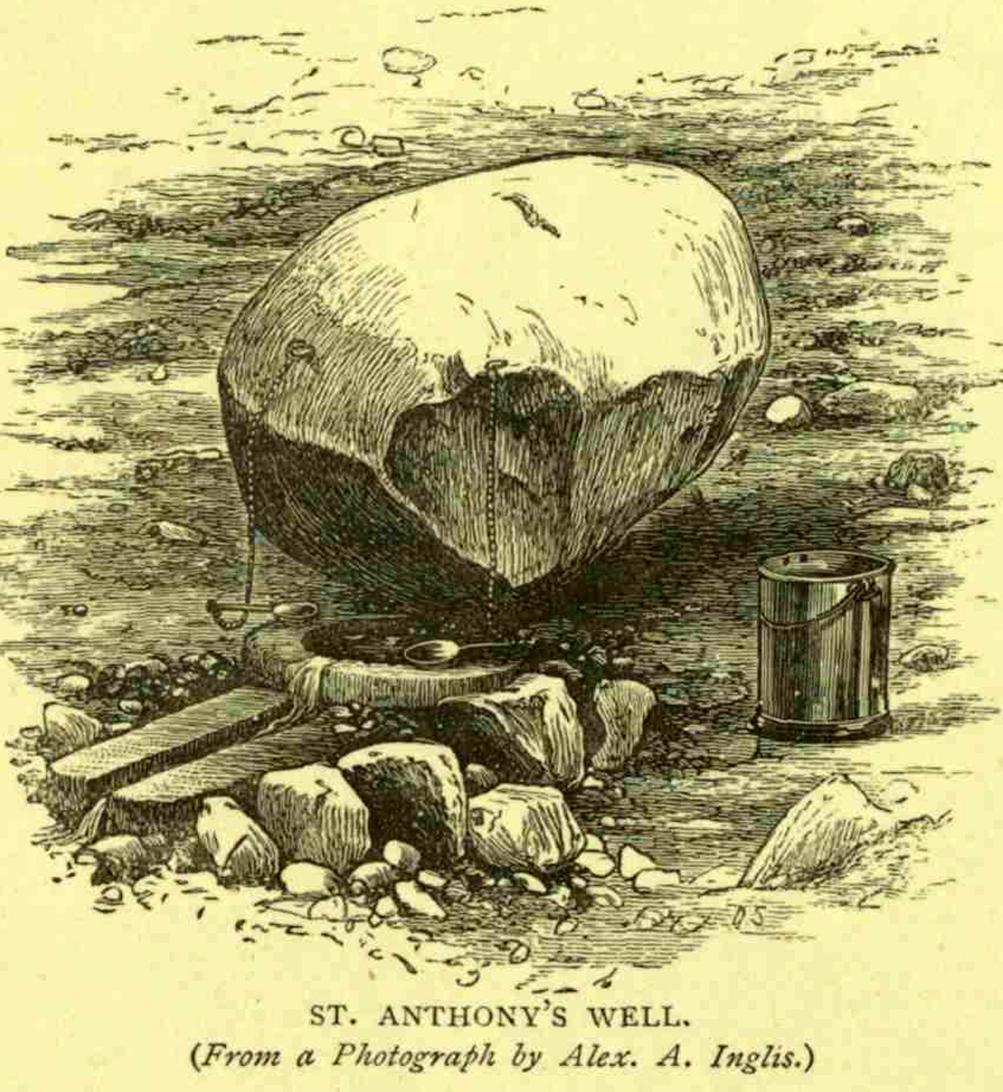
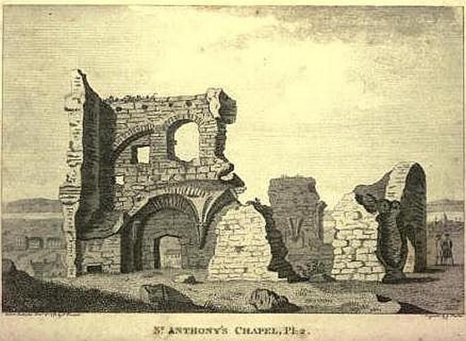
Not too difficult to find really. Get to the northern part of the road which encircles Arthur’s Seat and when you get to St. Margaret’s Loch (near St. Margaret’s Well), look up the slopes on your right where you see the remains of St. Anthony’s Chapel. You need to head up the footpath here until you reach a large-ish ovoid boulder, with a small circular trough into which the waters run (the drawing of the place here, with the rock in the lower-left, just in front of the fella walking towards it, is just right!). You’re here!
Archaeology & History
St Anthony’s Well, Arthurs Seat
Tradition tells that the remains of St. Anthony’s Chapel was built on the northern ridge by Arthur’s Seat, “mainly for guardianship of the holy well named after the saint” — which sounds rather like the christianization story of a heathen site. Francis Grose (1797) told that “this situation was undoubtedly chosen with an intention of attracting the notice of seamen coming up that Frith; who, in cases of danger, might be induced to make vows to its tutelar saint.” If this was the case, it sounds even more like a site that had prior heathen associations. Grose also told us that just a short distance from the chapel, were the remains of an old hermitage:
“It was partly of masonry worked upon the natural rock. At the east end there are still two niches remaining; in one of which formerly stood a skull, a book, an hour-glass, and a lamp, which, with a mat for a bed, made the general furniture of the hermitage.”
I like the sound of the place! Just up my street! Little other archaeological info has emerged from this tiny spot — but the healing waters of the well would obviously have been of importance to our indigenous inhabitants (anyone who wants to think otherwise is simply a bit dim!) as there is a wealth of archaeological sites and relics all round Arthur’s Seat.
Folklore
A number of writers have described this old well, which has sun-lore, healing properties, and Beltane rites surrounding its past. Local people of all social classes frequented this ancient spring, particularly on that most favoured of heathen days, Beltane. The site was of considerable mythic importance with a certain order about it. As Hone (1839) said:
“…the poorer classes in Edinburgh poured forth at daybreak from street and lane to assemble on Arthur’s Seat to see the sun rise on May-morning. Bagpipes and other musical intruments enlivened the scene, nor were refreshments forgotten. About six o’ clock a crowd of citizens of the wealthier class made their appearance, while the majority of the first-comers returned to the town. At nine o’ clock the hill was practically deserted.”
Another early account describing St. Anthony’s Well is from an article in the great PSAS journal of 1883. Here, J.R. Walker wrote:
St Anthonys Well
To an incident which showed that the faith and belief in the healing virtues of the wells is still strong, the writer was but a few months ago an eye-witness. While walking in the Queen’s Park about sunset, I casually passed St. Anthony’s Well, and had my attention attracted by the number of people about it, all simply quenching their thirst, some possibly with a dim idea that they would reap some benefit from the draught. Standing a little apart, however, and evidently patiently waiting a favourable moment to present itself for their purpose, was a group of four. Feeling somewhat curious as to their intention, I quietly kept myself in the back ground, and by and by was rewarded. The crowd departed, and the group came forward, consisting of two old women, a younger woman of about thirty, and a pale, sickly-looking girl — a child of three or four years old. Producing cups from their pockets, the old women dipped them in the pool, filled them, and drank the contents. A full cup was then presented to the younger woman, and another to the child. Then one of the old women produced a long linen bandage, dipped it in the water, wrung it, dipped it in again, and then wound it round the child’s head, covering the eyes, the youngest woman, evidently the mother of the child, carefully observing the operation, and weeping gently all the time. The other old woman not engaged in this work was carefully filling a clear flat glass bottle with the water, evidently for future use. Then, after the principal operators had looked at each other with an earnest and half solemn sort of look, the party wended its way carefully down the hill
Earlier still we find more lore of the place in Wilson’s Edinburgh [1848] where he told:
St Anthony’s Chapel 1785
“The ancient Hermitage and Chapel of St. Anthony, underneath the hangings of Arthur’s Seat, are velieved to have formed a dependency of the preceptory at Leith, and to have been placed there, to catch the seaman’s eyes as he entered the Firth, or departed on some long and perilous voyage; when his voews and offerings would be most freely made to the patron saint, and the hermit who ministered at his altar. No record, however, now remains to add to the tradition of its dedication to St. Anthony; but the silver stream, celebrated in the plaintive old song, ‘O waly, waly, up yon bank,’ still wells clearly forth at the foot of the rock, filling the little basin of St. Anthony’s Well, and rippling pleasantly through the long grass into the lower valley.”
Votive offerings made here eventually turned the waters into a simply wishing well for incomers, even in Victorian times (oh how the locals must have hated such trangression…). The great Scottish holy wells writer J.M. MacKinlay (1893) told in his day the tale of,
“a little girl from Aberdeenshire, when on a visit to Edinburgh, made trial of the sacred spring. She was cautioned not to tell anyone what her wish was, else the charm would have no effect. On her return home however, her eagerness to know whether the wish had…been fulfilled, quite overcame her ability to keep the secret. Her first words were, ‘Has the pony come?’ St. Anthony must have been in good humour with the child, for he provided the pony, thus evidently condoning the breach of silence in deference to her youth.”
In the middle of the 20th century, the great folklorist F.M. MacNeill (1959) wrote:
“Even in Edinburgh, little bands of the faithful may be seen making their way through the King’s Park to Arthur’s Seat, and, as in the eighteenth century:
On May-Day, in a fairy ring,
We’ve seen them round St. Anton’s spring,
Frae grass the caller dew-drops wring,
To weet their een,
And water clear as crystal spring,
To synd them clean.”
And when Ruth and Frank Morris (1982) got round to their excellent survey, they found that this old well was still being used “by youths and maidens, who come to wash their faces with the dew on May Day mornings, a wish at St. Anthony’s being a part of the ritual.” But this final remark may have the simple prosaic coincidence of them observing people like I, when younger, who frolicked with girlfriends around May morning, in the grasses near the old well — though at the time I knew nothing about the old sacred waters on the slopes just above us!
Stone Circle (destroyed): OS Grid Reference – SE 748 282?
Archaeology & History
I’ve looked and looked for info on this seemingly lost site, but have found very little. It lent its name to the very woodland within, or on whose edges, it could once be found. First described as early as 1284 in the ‘Calendar of Patent Rolls’ – where is appeared as ‘Ringestainhirst‘ – and then in the Testamenta Eboracensia in 1391, it is mentioned several other times before falling into nothing but literary memory in the middle of the 19th century.
We don’t know for sure where the circle was located, though one Latin reference describes it in proximity to a hermitage once known as St. Mary Magdalen’s Chapel at Howden: “heremitae de Ryngstanhyrste.” The site would likely have been on the highest point in the locality, which may put it where the great church now stands, or perhaps on the more northern and western outskirts of the township. Are there any Howden historians reading this who might be able to throw a bit more light on the issue?
The great place-name authority A.H. Smith (1937) thought that the Ringstone Hurst (woodland) at Howden got its name from a “wood near the circular stone”; but modern etymologists would place a much greater likelihood that the woodland owed its name to the now lost stone circle that was once in this locality.
References:
Raine, James (ed.), Testamenta Eboracensia; or, Wills Registered at York, J.B. Nichols: London 1836.
Smith, A.H., The Place-Names of the East Riding of Yorkshire, Cambridge University Press 1937.
Various ways to get here, but I suppose the easist is by walking along the path just above the woods from the main A61 road, where there’s the junction turn-off to Wike. You have to walk perhaps 1000 yards until eventually, a couple of hundred yards up the slope to your left (south) you’ll see the boulder stuck in the field. You’re there!
Archaeology & History
The Grey Stone, Harewood
Described first by Cowling & Hartley in 1960, this multiple-ringed carving gives the distinct impression that it aint quite as old as our more traditional cup-and-rings on the moors west and north of here – but I s’ppose we’ll never know for sure. There isn’t a central cup to this concentric-ringed carving, which is quite unusual, and which is why I get the impression that it’s from a later archaeological period. However, saying that, there are several other faint cup-markings on the southwest and east-faces of the boulder (which I forgot to photograph when I was there – idiot that I am!). Boughey and Vickerman (2003) illustrate as many as 18 other cup-marks on the rock surface – which they list as stone 399 in their survey.
Although there seems to be no folklore attached to this isolated carving, rock-art authority Graeme Chappell noted how “the midwinter full moon set behind Almscliffe Crags at its extreme northerly setting point in Bronze Age times” from this Grey Stone.
The archaeologist S.A. Moorhouse (1981) also pointed out how some of the many Grey Stones (which usually means ‘a boundary stone’, sometimes very ancient ones) found in northern England, derive their name from the old word har, which “can also mean ‘grey, hoar,’ used to describe natural boulders, possibly with cup-and-ring markings” – just as we have here!
References:
Bennett, Paul, The Old Stones of Elmet, Capall Bann: Milverton 2001.
Boughey, Keith & Vickerman, E.A., Prehistoric Rock Art of the West Riding, WYAS: Wakefield 2003.
Cowling, E.T. & Hartley, C.E., ‘A Ring-Marked Rock: The Grey Stone,’ in YAJ 1960.
Moorhouse, S.A., ‘Boundaries,’ in Faull & Moorhouse’s West Yorkshire: An Archaeological Survey, volume 2, 1981.
Easy enough to find once you’ve actually got to Wycoller. By car, the only real way to get here is from Colne, through the village of Winewall, and along the Wycoller road, which runs to a dead end. Once here, the old packhorse bridge with these cup-marks on it can’t be missed!
A weird one this! On the famous packhorse bridge close to the old hall, four of the stones have cup-markings etched onto them. It seems that at least three of the carvings are archaic; with cups on one of the stones being somewhat deep and may actually be medieval. But we simply don’t know…. A short article describing them was in the Bradford Cartwright Hall Archaeology Bulletin (1962) where they were equally as puzzled about them. In 1979, J.A. Heginbottom described them in his survey on the prehistoric rock-art of upper Calderdale. It’s possible that the stones on which the cups were carved might have been taken from a prehistoric tomb on the edge of the moor further up the valley from here.
Folklore
Just next to this bridge is another, much older one, known locally as the Clapper or Druid’s Bridge which perhaps has some bearing on the curious cup-markings. Legend tells that this older construction was so called “because legend has it that it led to an amphitheatre where the druids held human sacrifices” – and the field just up from here (to the southwest) was known as the Dripping Stone Field. Hmmmmm…..
References:
Bentley, John, Portrait of Wycoller, Nelson Local History Society 1975.
Heginbottom, J.A., The Prehistoric Rock Art of Upper Calderdale, unpublished report: 1979.
Jackson, Sidney, ‘Cup-Marked Stones at Wycoller,’ in Cartwright Hall Archaeology Group Bulletin, October 1962.
Settlement (destroyed): OS Grid Reference – SJ 959 928
Archaeology & History
Known by this name – Werneth – since at least the 12th century, place-name masters Ekwall, Smith and others have tended to think the place derives from a hypothetical British word, *verno-, meaning alder trees – though I aint so sure misself.
It’s been difficult to ascertain the precise nature of this prehistoric arena. Many mesolithic flint finds and old stone axes have been found around the area, but it seems primarily to have developed into a neolithic and Bronze Age settlement and burial site. A number of cairns were once here, and both rounded and linear earthwork features occur in the area; but there’s been considerable disturbance in and around the site and without in-depth archaeo-surveillance, much remains hidden.
Along the A61 Harrogate-to-Harewood road, just below the roundabout where the A658 links up, is a small country road that turns towards the lovely village of Kirkby Overblow. If you’re in a car, park up wherever you can hereabouts (being careful of the locals!). Cross over onto the western-side of the A61 and walk along the small tree-lined field-edge until you find a spot to get over, where this stone stands.
Archaeology & History
It’s hard to suss out how many monoliths first stood here, but when William Grainge (1871) and Harry Speight (1903) described them, it was believed they had been uprooted in the 17th or 18th century. Although one of them has gone, thankfully the scarred remnant of one is still here.
Site number 168 in Old Stones of Elmet, one of the two standing stones that were described in parish boundary records of 1577 as “two stones standing in Walton Head Layne” can be found northeast of the village, along the ancient church way between Rigton and Kirkby. However, it is not as it once was! The boundary perambulation was redefined in 1767, when it was thought that a new monolith had been erected to replace the site of the old ones; but it turns out that some masons simply smoothed off the old stone and carved ‘K.F. 1767’ onto one of the original two. If you look at the base of the stone (which is more than 4 feet tall, leaning slightly to one side), it’s obvious that it’s been in the ground for one helluva long time. Much much longer than any old 1767 – or 1577 for that matter! What we appear to have here is simply a worked remnant of a true prehistoric standing stone.
References:
Grainge, William, The History and Topography of Harrogate and the Forest of Knaresborough, John Russell Smith: London 1871.
Speight, Harry, Kirkby Overblow and District, Elliott Stock: London 1903.
The best way to locate this is probably by starting from the pub opposite the old church of St. Leonard and heading west along the village road, past three large gate-entrances, until reaching the conspicuous milestone by the road junction. On the other side of the road, just before the gate entrance to Downham Hall, edged into the base of the wall, we find this ‘ere The Great Stone.
Archaeology & History
The Great Stone, Downham
What a truly beautiful little village we find in Downham, nestled quietly and with age at the northern edge of Pendle hill. It’s tucked away, off any main road so maintaining its sense of age and almost reclusive nature. There is hidden history a-plenty scattering the landscape here, but tales of our Great Stone — thought by some as an old monolith; remains of a Roman milestone by others; whilst some just denote it as nowt but a small stone — is what brought me here. It’s name betrayed my expectation (I always hope for too much it seems…), but the small pock-marked stone has been embedded in its present position for at least 150 years, as the growth of soil and tree behind it shows. Archaeo-historians say little of it (reputations y’ know!) until something substantial is found; but thankfully we came upon the lovely couple who are Lord and Lady Clitheroe of Downham Hall, who told us more…
Folklore
“There are a couple of humourous legends told of the Great Stone,” Lord Downham began… But to a (sometimes) courteous megalithomaniac like myself, the tales rang the all-too-familiar bell.
Close-up of the Great Stone
The original position of the stone, though not known for certain, was some short distance away either across the road, or further along in a nearby field. When it was moved – Lord Downham said around 1830 – the remains of a body were found beneath it; but another source told in fact that it marked “the final resting place of two legionaries who died on the nearby Roman road during trouble with the Brigantes.” (An old Roman road is nearby) But apparently this old stone also moves. When the church bell strikes midnight the stone is said to turn itself around upside-down. Where have we heard that before!?
The site is described in Clifford Byrne’s (1974) unpublished manuscript on the crosses of Lancashire, where he cites it as being the remains of a cross pedestal, but adds that “if ever a cross stood by the village green, no memory of seems now to exist.” But Mr Byrne also described the all-too-familiar heathen folk tales, saying:
“A local man told the writer that the object is called Downham Stone and that it turns over every night at midnight. We read elsewhere that the boulder is called “the great stone of Downham” and that it turns at the stroke of midnight by the church clock.”
References:
Byrne, Clifford H., “A Survey of the Ancient Wayside Crosses in North East Lancashire,” unpublished manuscript, 1974.
Lofthouse, Jessica, Three Rivers, Robert Hale: London 1946.
Lofthouse, North Country Folklore, Robert Hale: London 1976.
Winterbottom, Vera, The Devil in Lancashire, Cloister: Stockport 1963.
Stoodley Pike is unmissable! Get to either Hebden Bridge or Todmorden – ask someone – then get to it! Nice climb – nice view – excellent moors all round!
Archaeology & History
Artist’s impression of Stoodley Pike Circle (bottom left of ruin)
All traces of this site have gone, but local gossip still tells there was once something here. When building work commenced on the huge folly in 1814, in clearing the ground “an accumulation of stones (and)…a quantity of bones” were unearthed. After the huge folly had been built, a curious ritual was made by local Freemasons, from here to the nearby Slake Well. The circle was only a small one, but ideal for the spirit of the ancestor to both look-out from, and fly across the landscape. In another description of the place from 1832 — wrote E.M. Savage (1974) — local writer and poet, William Law, told how “a rude heap of stones had stood on the site from time immemorial.”
Folklore
Suggested by earlier writers to have been an old beacon site, though evidence for this is uncertain. The site was said to be a meeting place of the “gude grannies,” who met here and told old stories. E.M. Savage (1974) told us:
“Another story was that the cairn marked the grave of an old chietain and that the bones of a human skeleton had been found… A contemporary of (William) Law, called Holt…stated that this was so. Another story was that someone had been murdered and buried there. Many years later, Law quizzed the workmen. Bones had been found but no one knew whose bones, or their age, so the mystery remained.
“Yet another story had it that the occupant, presumably owner, of Stoodley, had to keep the original Pike, the cairn, in neat and good order. If a single stone was out of place, no one could sleep. The banging of doors and other noises started up, to remind the owner to tidy up the stones. Elusive flames were to be seen playing round the stones. Sor the stories went.”
As can be seen in the artist’s drawing above, done more than a century after the cairn had been destroyed, a ring of stones is shown just below the remains of the earlier of the Peace Monuments, which today carries the old name of Stoodley Pike.
References:
Booth, Thomas, Ancient Grave Mounds on the Slopes of the Pennine Range, R. Chambers: Todmorden 1899.
Savage, E.M., Stoodley Pike, Todmorden Antiquarian Society 1974.