Having not been here, I can’t say for sure exactly where this forgotten site happens to live! It may be the one shown on modern OS-maps, behind the old post office, on the west-side of the village, but I aint sure. If any local people out there who can help us, we would be hugely grateful!
Archaeology & History
Not to be confused with the other St. Michael’s Well a few miles away in the village of Well, this is a little-known holy well that was described by the historian H.B. McCall (1910), who wrote:
“As Burneston had Saint Lambert’s Fountain, mentioned so early as the 12th Century, so Kirklington possesses its holy well, beside the old Mill House on the north side of the village. Althoguh its name has now passed from the popular remembrance, it is provided in a lease of lands to Roger Croft, in 1628, that his cattle shall have right of access to go into the water near unto a spring called ‘Michaell-well’. both in winter and summer; and we are left in no doubt as to where the spring was situated, for Mrs Alice Thornton has recorded that her father brought water to the Hall in lead pipes from a cistern of the same metal, “near St. Michael’s Well near the mill-race.””
Does anyone know anything more of this all-but-forgotten site?
A short distance to the north in the same village, another sacred water source known as the Lady Well can also be found.
References:
McCall, H.B., Richmondshire Churches, Elliott Stock: London 1910.
Found near the bottom of Holly Hill, as Graeme Chappell tells us, this old site “is located by the side of a narrow lane on the west side of the village of Well (aptly named). The OS map places the well on the north side of the lane, but this is only the outflow from a pipe that carries the water under the road. The spring actually rises at the foot of a small rock outcrop, on the opposite side of the road.”
Archaeology & History
St. Michael’s Well, Well (Bogg 1895)
Although the village of Well is mentioned in Domesday in 1086 and the origin of the place-name derives from “certain springs in the township now known as The Springs, St. Michael’s Well and Whitwell,” very little appears to have been written about this place. Edmund Bogg (c.1895) wrote that an old iron cup — still there in the 19th century — was attached next to this spring for weary travellers or locals to partake of the fine fresh water. Nearby there was once an old Roman bath-house and, at the local church, one writer thinks that the appearance of “a fish-bodied female figure…carved into one of the external window lintels” is representative of the goddess of these waters. Not so sure misself — but I’m willing to be shown otherwise.
Folklore
Around 1895, that old traveller Edmund Bogg once again wrote how the villagers at Well village called this site the Mickey or Mickel Well,* explaining: “the Saxons dwelling at this spot reverently dedicated this spring of water to St. Michael.” A dragon-slayer no less!
Although not realising the Michael/dragon connection, the same writer later goes on to write:
“There is a dim tradition still existing in this village of an enormous dragon having once had its lair in the vicinity of Well, and was a source of terror to the inhabitants, until a champion was found in an ancestor of the Latimers, who went boldly forth like a true knight of olden times, and after a long and terrible fight he slew the monster, hence a dragon on the coat of arms of this family. The scene of the conflict is still pointed out, and is midway between Tanfield and Well.”
This fable occurred very close to the gigantic Thornborough Henges! It would be sensible to look more closely at the mythic nature of this complex with this legend in mind. A few miles away in the village of Kirklington, the cult of St. Michael could also be found.
References:
Bogg, Edmund, From Eden Vale to the Plains of York, James Miles: Leeds n.d. (c.1895)
Smith, A.H., The Place-Names of the North Riding of Yorkshire, Cambridge University Press 1928.
* In old english the word ‘micel‘ (which usually accounts for this word) means big or great. On the same issue, the ‘Holly Hill’ in the case here at Well actually derives from the holly tree and NOT a ‘holy’ well. However, check the folklore of this tree in Britain and you find a whole host of heathen stuff.
Stone Circle (destroyed): OS Grid Reference – SD 822 387
Also Known as:
Pendle Stone Circle
Archaeology & History
A destroyed site mentioned by several local historians. It was positioned at the valley bottom just below Faughs, a hundred yards west of Lower Moss End, where today it is simply overgrown meadows with the typical excess of Juncus reeds. As local investigator John Dixon said, there are “five stones shown on (the 1848) map just west of Spen Brook Mill.”
In the 1970s, one writer described there being several uprights still in place, but a visit here a few weeks back (though I – unusually! – didn’t walk all through the boggy grounds and explore as extensively as I normally would) found nothing.
Its geomancy, however, was striking. The unnamed hill immediately to the north of its position (at the southern end of the legendary Pendle Hill, a coupla hundred yards west of St. Mary’s church) rises up like a great singular ‘pap’ which, to our old ancestors, was animated with female spirit. I sat here in the pouring rain looking up at this hill and its presence in front of the circle was striking.
…And so I walked onto the top of the said hill. Thereupon I found a small gathering of rocks, not unlike a cairn-spoil. When I enquired with a few local people about the age or nature of this rock-pile, I found no-one seemed aware of its existence. Weird. But from the hill itself, the view is excellent – and the small valley amidst which the old circle once stood teems with legends and myth: of cailleachs, ghosts, wells, witches and more. An excellent spot!
The local writer, historian and walker, John Dixon, sent us the following notes of his exploration here:
“Clifford Byrne, the late Nelson antiquarian, mentions in his book ‘Newchurch in Pendle’ the site of a former stone circle that stood just below Faughs, a hundred yards west of Lower Moss End. Today no large stones of any kind can be located anywhere near this spot, the stones having been removed or broken up some time in the past. However, the 1848 6” OS map records the number and position of these stones as being in two parallel lines about a hundred yards apart lined up west to east. The northerly line (SD 823 389) consists of 3 stones, the southerly (SD 823 387) of 4 stones, all being some 3 yards apart.
“It appears that we have an avenue of stones, not a circle. But why their position in the landscape at the headwaters of two valley streams? The Sabden Brook starts its journey westward to meet with the Calder from the stones, while Dimpenley Clough rises from the stones running east to join Pendle Water – could this be of any significance?”
References:
Byrne, Clifford, Newchurch-in-Pendle: Folklore, Fact, Fancy, Legends and Traditions, Marsden Antiquarians: Nelson 1982.
One of two ways to get here really. The easiest is from Sutton-in-Craven: go through the village and up the steep hill (don’t take the right turn as you start up the hill). Go all the way up until the hill starts to level out and on the left-side of the road you’ll notice a boundary stone stood upright (this is the Sutton Stoop). Stop here. Of the 2 gates, climb over the top-most one and walk down the path into the adjacent field, heading over to the gap a couple of hundred yards away where the gate to another field is. That’s it!
Archaeology & History
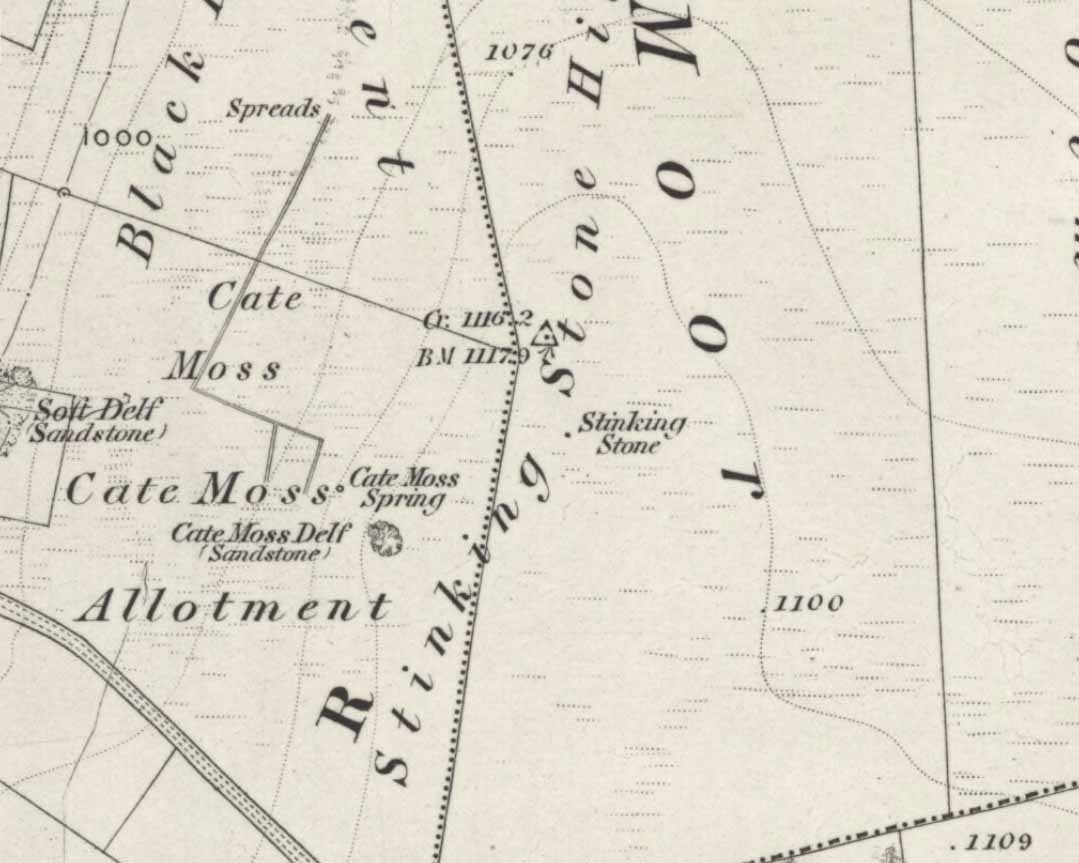
Stinking Stone, Steeton
Now here’s a weird one. With a name like this you’d expect there to be plenty of info or historical comments. But despite all the books and journals in my huge library, aswell as visiting town libraries and exploring the resources on-line, there’s nowt written about this ‘ere spot. Not a jot! Even the usually satisfactory place-name fellas have a thing-or-two to say about sites with names such as this—but even their old tomes are closed-lipped. Hmmmmm…..
I visited the place several times to try ascertain what this site was, thinking — perhaps — that it was an old boundary stone whose name had been convoluted from some older, more obvious title.* The nearby Sutton Stoop boundary stone, right by the roadside, seemed a good indicator to such an assumption, as it was a recognised boundary marker with written history and a meeting point along the local perambulation. But the curiously-named Stinking Stone was neither on the same line, nor ever had been according to old records, and couldn’t be located either. There had been obvious quarrying and other industrial destruction along the hilltop where the old stone was marked and it seemed logical to assume that it had been destroyed in bygone years by that usual breed of capitalist industrial halfwits. Until a psilocybin venture one afternoon, last season…
Twas a lovely sunny day, though windy on the tops as usual. I was out with a couple of neophytes showing them Psilocybes and various other species, chewing them here and there and talking the way of healthy usage. We passed by an old well, long forgotten, before heading onto Stinking Stone Hill. Bimbling somewhat, and ruminating about the moss of colour, we decided to sit by the walling in-field and dream for a short while. As we hit the old gate the Stinking Stone came up right before us. Literally!
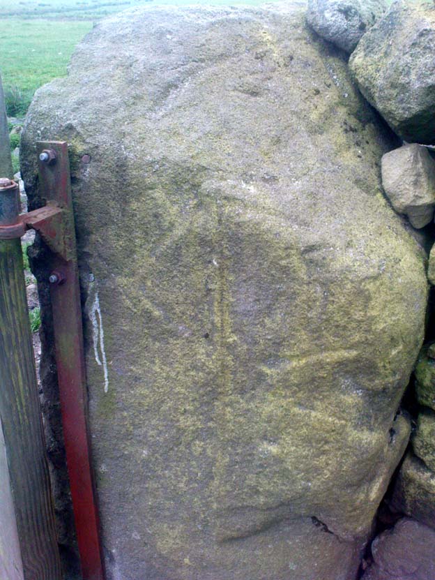
There in the old walling, blunt as you like, stood this four-and-a-half-foot tall standing stone, smoothed on one side by a short aeon of weathering, upright and proud as if it had been stood there for centuries, awaiting attention! I exclaimed a few triumphant expletives; rubbed myself here and there over the old thing, then sat for a while behind the wind with the old upright, solidly embedded in old earth — then awaited the dream…
Twas a good day…
And then I returned home and later sought what I could on a possible etymology. Around the hilltop a hundred yards away were small depressions and the faded remains of industrial workings, like I said; and with this in mind the awesome Mr Wright (1905) told us about the existence of ‘Stinking coals’, “an inferior kind of coal” no less. Referring us to a work from 1818, we’re told,
“The Stinking-coal is noted for containing a great proportion of sulphuret of iron, thick seams or layers of these pyrites running in it. In consequence of this it cannot be used for smelting purposes.”
Another account from 1868 telling us that:
“On opening the body, it contains a strong sulphureous smell, characteristic of the disease; hence it is called the stinking ill; and the stomach and bowels are prodigiously distended with air, having the same intolerable foetor.”
Worn metal scratches, made when dragged here?
This old worn gatepost however, perhaps has a history that only goes back a few centuries. It has been cleaved in half, as you’ll see if you visit it; but its western face is old and worn and it’s been embedded in the ground for a long time. On its northern face are the curious etchings of carvings, which are more akin to wounds from some past offence (perhaps when it was split in half), cleaved by metal toolings and dragged by farmers to be fixed in into present spot. It’s history may not be truly ancient. Twouldst be good to know for sure though…
References:
Wright, Joseph, The English Dialect Dictionary – volume 5, Henry Frowde: Oxford 1905.
* ‘Stinking’, stone-king or King Stone? Unlikely though…
Go through Haworth and head for the well-known Penistone Hill country park. On the far western side of the hill up near the top of Moorside Lane, there’s a car-park. Right across the road from this there are two footpaths: one heads you into the moor, whilst the other (going the same direction) follows the edge of walling onto the moors. Take this path. Walk on and downhill, past the end of the reservoir, then the path continues uphill. You’ll hit a nice cheery tree beside the path a few hundred yards up. Stop here, look into the boggy region with bits of walling on the moor in front of you. That’s where you’re heading!
Archaeology & History
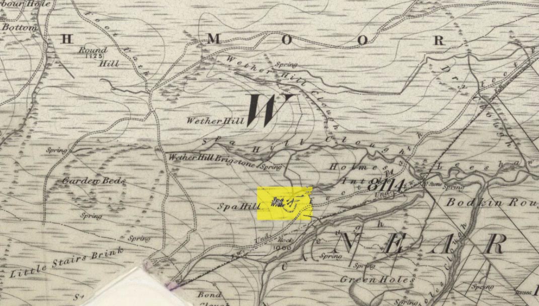
The first, weaker of the Spa Wells
This was a really curious spot to me, as I found absolutely nothing about the damn place! But thanks to the assistance of local historian and writer Steven Wood (2009), that’s changed. Shown on the 1852 OS-map, at least two springs of clear water trickle slowly from the wet slope above you into the boggy reeds. Close by there are overgrown remains of old buildings, covered with the time of moorland vegetation, seemingly telling that the waters were collected for bathing rooms. But who the hell even started the notion that they’d be able to get Victorian rich-folk up here at the crack-of-dawn to drink or bathe in the waters is seemingly forgotten. And, as is evident from the lack of local history, the project was a failed one which seemed not to have lasted too long.
Folklore
The stronger Spa Well
It was quite obvious that of all the springs around here and despite the strong-flowing streams either side of these spa well, that the local animals drink here more than the other nearby springs of water, as there were literally hundreds of animal tracks all across the boggy ground of the spas.* The waters also seem to have the usual ‘spa’ qualities of stinking, but once we’d cleaned out the overgrown springs — which looked as if they hadn’t been touched for 100 years or more — the waters were clear and tasted good, and were curiously slightly warm!
Although my initial search for information on this site drew a blank, Steve Wood pointed us in the right direction for info on the place. As with many other holy wells and spas in Yorkshire, it turned out that this was another spot much revered around Beltane, indicating strongly there would have been earlier pre-christian rites practiced at this site. Steve pointed me to Martha Heaton’s (2006) local history work, which told:
“For many years the first Sunday in May was a special day. It was known as Spa Sunday, for on this day people gathered up in the hills overlooking what is now Leeshaw Reservoir, here was a well, known as Spa Well, and the stream which now feeds the reservoir is known as Spa Beck. People came from Haworth, Oxenhope, Stanbury, and other villages sitting round the well, they sang songs, some bringing their musical instruments to accompany the singing. Children brought bottles with hard spanish in the bottom filling the bottle with water from the well, shaking it until all the spanish or liquorice had been dissolved. This mixture was known as ‘Poppa Lol’ and would be kept for weeks after a little sugar had been added, then it was used sparingly as medicine. The custom seems to have died out when Bradford Corporation took over the water and made Leeshaw Compensation Reservoir in 1875, though up to about 1930 two men from Haworth would wend their way to the spot on the moor, the first Sunday in May. The men were John Mitchell and Riley Sunderland, better known, in those days as ‘Johnny o’Paul’s’ and ‘Rile Sun’.
It was a great day for many people, the Keighley News of May 1867 mentioned it, the report of local news reads thus: ‘A large assembly met on Spa Sunday on the moors about two miles from Haworth, and a party of musicians from Denholme performed sacred music’.
This locality was often visited during the summer months by the Bronte family.”
References:
Heaton, Martha, Recollections and History of Oxenhope, privately printed 2006.
Wood, Steven & Palmer, Ian, Oxenhope and Stanbury through Time, Amberley Publishing 2009.
Acknowledgements: – Huge thanks to Steven Wood for his help; and to Hazel Holmes for permission to quote from Martha Heaton’s work.
* A common creation myth behind many healing wells is that animals with breaks or illness drag themselves to drink from otherwise small or insignificant springs and wells, despite of the copious streams or rivers which may be nearer.
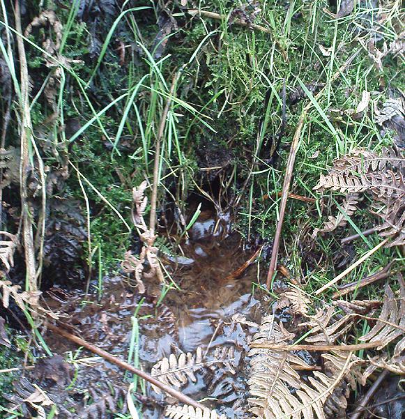
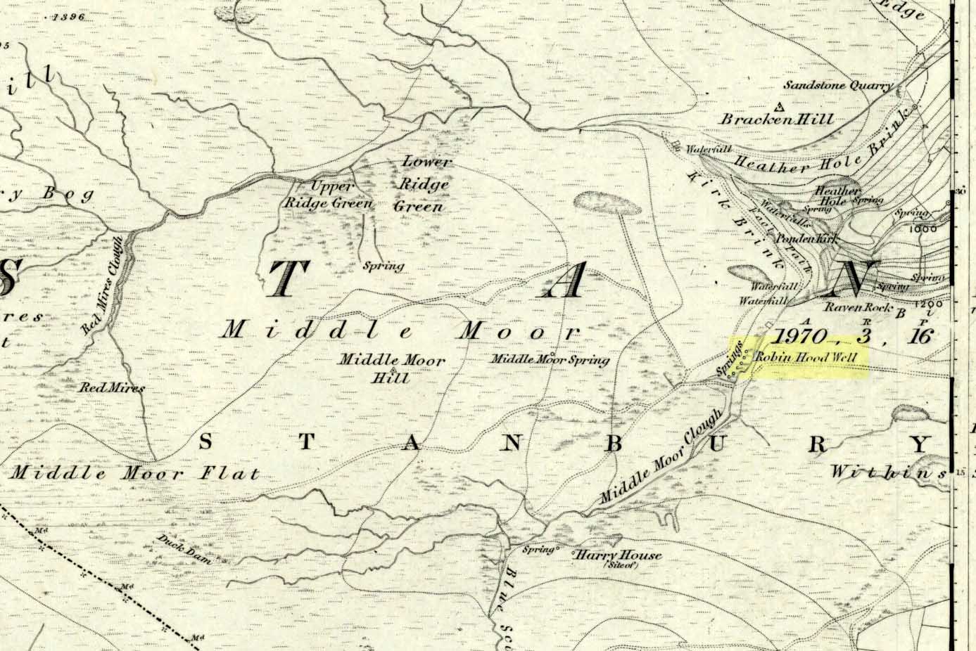
Follow the same directions to get to the nearby Ponden Kirk and, once on top of the rocks, overlooking the valley, walk on the footpath to your right. It bends round and follows the stream up onto the moors. About 100 yards along, walk up the heathery slope to the right and you’ll find several boggy watering holes on the top of the ridge. In looking at the first OS-map of the area in 1853, it seems that the northernmost of six boggy springs is the Robin Hood’s Well – although we don’t know this for certain. It’s one of them though!
Archaeology & History
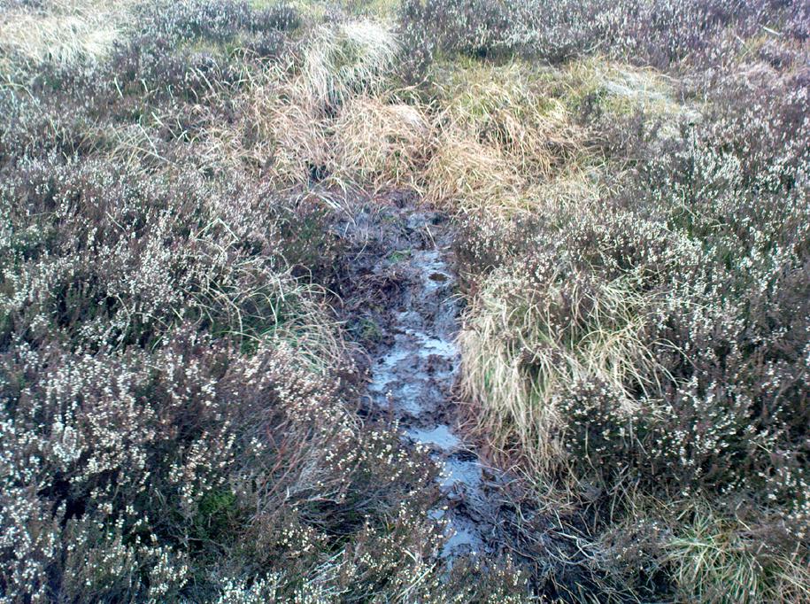
Robin Hood’s Spring, above Ponden Kirk
There’s little to see here really: it’s little more than a small boggy spring of water emerging from the edge of the ridge, as the photo shows. Curiously, descriptions of the site (and its neighbouring compatriots, Will Scarlett’s Well and Little John’s Well) are sparse aswell. It was noted by the Ordnance Survey lads in 1848 and subsequently posted on the first OS-map of the area in 1851. Both Horsfall Turner (1879) and Johnnie Gray (1891) mention the site passing, saying nothing of the place. However, several years after Gray’s work, Halliwell Sutcliffe (1899) ventured here and gave us the first real description of the place, telling:
“Half-hidden underground, and fringed with fern and bog-weed, lie the three wells which go by the names of Robin Hood, Little John and Will Scarlett. One may stop to ask how they came by their birth-names, to wonder why a man should have troubled to fashion them in this out-of-the-way spot; but neither speculation nor questioning of the moor folk brings one nearer to an answer.”
Folklore
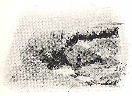
Halliwell Sutcliffe’s scruffy quick sketch, circa 1898
Apart from this site being a spot where the legendary outlaw stopped and drank in ages past, the healing attributes of these waters have long since been forgotten. Considering the proximity of the Ponden Kirk and its legendary association with fertility and marriage rites, I’d guess that such lore wold have centred around Beltane, or Mayday; and Robin Hood is very well known in folklore to have close associations with the same period. So — and I’m guessing here — it’s likely that whatever might have occurred at this well, would have taken place around Beltane aswell.
References:
Gray, Johnnie, Through Airedale from Goole to Malham, Walker & Laycock: Leeds 1891.
Sutcliffe, Halliwell, By Moor and Fell in West Yorkshire, T. Fisher Unwin: London 1899.
Turner, J. Horsfall, Haworth, Past and Present, Hendon Mill: Nelson 1879.
From Carlton, take the western Hirst Road to Temple Hirst village, then turn right once you’re in the village and go up Common Lane up for about a mile. There’s a footpath on your left leading you to the Fair Oaks farmhouse. This was the spot!
Archaeology & History
This is fascinating sounding place which marked the central point of three old township boundaries nearly 1000 years ago. I first found it mentioned in Morrell’s History and Antiquities of Selby (1867: 36-7), where this once famous tree is described in land sale transactions. Morrell told:
“At Carlton the (Selby) abbey had considerable property, which was sold to the neighbouring priory of Drax. The boundary of the property sold was a certain oak tree, called Fair-haia, in Burn Wood, which Adam de Bellaqua gave for this purpose, binding himself and his heirs never to cut it down or root it up, sub poena anathematis.”
But we found a more detailed outline in Dugdale’s Selby Abbey in Yorkshire, where the premises and townships given to Selby Abbey in the 12th and 13th centuries are listed. In the township of ‘Carleton’ (as it was then spelt) Dugdale wrote:
“Peter de Brus gave the grange here, which the monks had held of Agnes, late wife of Ranulph FitzSwain. Richard abbat of Selby granted to Robert prior of Drax all the tithe from the north part of the oak called Fair-haia, in the wood of Birne, or Berlay, through the middle of the marsh to Hundolfsweith; and from thence by the strait ditch directly to Espholm, and all the tithe from Espholme to Appletreholme, as the ditch goes to the new fosse or ditch of Carleton: and the prior granted to the abbat all the tithes on the south to the new ditch, and from thence to the river Ayre. And Adam de Bellaqua gave this oak tree, called Fair-haia, as a boundary, never to be cut down (ad standum in perpetuum et non rescindendum), binding himself and his successors never to cut it down or root it up.”
One wonders: are there any remains left of this once great tree? Has anyone actually transgressed and uprooted it in times past? Is any other lore known of it? And who was Adam de Bellaqua?
One of the most intriguing elements to this site is its name, for the word ‘haia’ literally means ‘god of the land’ — but whether we can take this meaning seriously is questionable, as it’s of Sumerian origin. However, no local dialect words throw any light on the word and it may aswell be the name of the spirit of the tree as anything else. Does anyone know owt more about this place?
Dead easy this one! Go along North Street in Keighley, towards the main church in the middle of town (a St. Andrew’s church, previously St. Pete), by the once-infamous Lord Rodney pub, and the old stone edifice stands outside by the Green. The much better Red Pig public house is across the road from here.
Archaeology & History
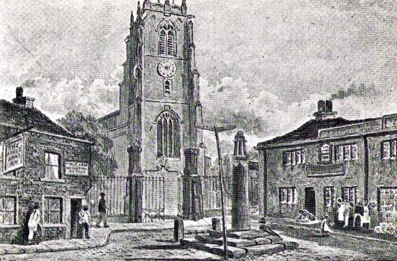
Keighley’s Town Cross, 1847 – on a painting by Edwin Riby
For a relatively trivial archaeological site, it’s got a bittova history. Not that this is an old site either! We’re not sure just when this cross was made, but it’s certainly no more than 300 years old. Before standing in its present position outside St. Andrew’s Church, sometime before 1840 it was said to have been a few hundred yards away above the present roundabout on Oakworth Road; and one record tells that it originally came from nearby Utley, a mile to the north. Due to lack of decent records, we’re not sure about its early status as a market cross, nor when it was first erected. Indeed, even the steps on which the cross presently stands are clearly more recent than the ones illustrated on Edwin Riby’s 1847 portrait, reproduced here.
Keighley Cross, on a grey wet day!
It would be good to get a complete history of this archaeological relic but it’s difficult with artifacts such as these; and although gaining access to the church now takes less time and effort than it used to (the vicar here used to be quite unhelpful, but has recently changed his ways – which is good!), it’s only open at certain times of the week.* Friday afternoons seem OK to have a look round. Please – if folk begin having trouble gaining access to the Church once more, let us know on here so we can make complaints about it. The Church is paid for by local tax-payer’s cash, and so needs to be open to all of us. Let’s hope this humble ingredient can be maintained for the good of all in this otherwise regressive social community (Keighley, that is…).
There’s also some very curious folklore to be added here in relation to the market and its cross, but its tale is gonna have to wait…
References:
Gray, Johnnie, Through Airedale, from Goole to Malham, Elliott Stock: London 1891.
Keighley, William, Keighley, Past and Present, R. Aked: Keighley 1858.
* There isn’t even a notice giving information, email or phone numbers, telling you who you can contact if you want to know anything about the history of the church, or visit it — which is quite dreadful considering how much money they get paid by tax-payers for their supposed socio-spiritual duties.
Now I aint been here for a few years, but it’s hopefully still where I last left it! You need to get into the trees behind the Christ’s Church just out of the town centre, along the south-side of the Burnley valley road. (A646) When you get to the footpath which runs just above the tree-line in the woods (it’s known locally as the ‘Lover’s Walk’ path), wander along for just a couple of hundred yards. You’ll eventually get to the small spring of water and the tiny stream which runs down the slope, just to the left of the path. According to the old map I’ve got – that’s it!
Archaeology & History
This long-lost sacred well originally emerged a little bit further up the hill from where it is today. Almost nothing is known about it. Seemingly first highlighted in 1852, my first “discovery” of the place came as a result of going through some local old maps I’d had the fortune of obtaining. In Victorian days when the site was much more prominent, the old road that took you into the woods was called Holy Well Lane. Now, its memory has been subdued, and the old road is known simply as ‘Well Lane.’
A local writer, J.W. Crowther, mentioned the site in his local place-name survey, where he told that the Holy Well was a “name given to a well of excellent spring water” — but nothing more. It was later mentioned in an article by J.A. Heginbottom [1988] who wrongly reported it as being “destroyed.”
Folklore
Local tradition told that ‘memaws’ (offerings such as rags, coins, flowers, etc) used to be left here by local people in olden times, as offerings to pacify or give respect to the waters; although what time of the year these were left, and the nature of the resident deity, has all been forgotten. In very recent years however, it seems that some modern NewAge-types are now visiting the place once again.
References:
Crowther, J.W., Place Names of Todmorden, privately printed: Todmorden (n.d.)
Heginbottom, J.A., ‘Early Christian Sites in Calderdale’, in PHAS 1988.
Healing Well (destroyed): OS Grid Reference – SE 0479 4179
Archaeology & History
The Whin Knoll Well, once found bursting into life at the top of Black Hill, Keighley, got its name from the old word ‘whin,’ or gorse bushes (Ulex Europaeus)—also known in Yorkshire as the ‘Spindly Killer Bush’: a most apt title! These great spindly killer shrubs once profused where the waters of this old well used to bubble into view – indeed, there are still quite a few great old spindlies still scattered here and there!
The site was shown on old maps as being just two fields east of the more renowned Jennet’s Well, but this old public water supply that once fed the local people, was covered by a reservoir many moons ago. However, a wander up here recently found the reservoir empty, but a water supply was still bubbling out of the ground into the great concrete hollow. The last remnants of the Whin Knoll Well perhaps…?