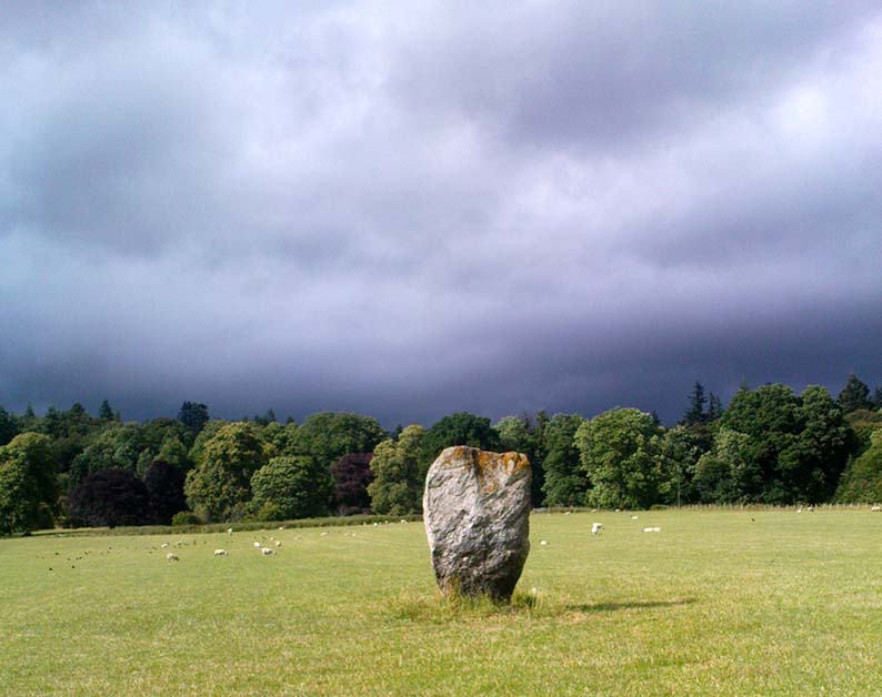
Going thru Pitlochry town, turn up the A924 road for about a mile till you hit the Moulin Inn on your left-hand side. Just past here, take the road left and continue for 2-300 yards until the stone in the field stands out on your right-hands side. Y’ can’t really miss it!
Archaeology & History
I should mebbe have this site entered as a ‘stone circle’ and not just an old monolith, as numerous other standing stones were in close attendant not too long ago and it was said to have been a circle. Certainly when the great Fred Coles (1908) talked about this place, he
“was informed by the tenant, Mr Reid…that many years ago, in his grandfather’s time, “there were several more stones standing”, all smaller than this monolith and that, upon the orders given by Mrs Grant Ferguson of Baledmund, some of these were saved from total demolition, and are supposed to be lying half-buried in the field to this day.”
…and here’s the big man close-up
Though I imagine these remnants have now been removed. Aerial images, when conditions are just right, might prove fruitful here.
But the solitary stone still standing here is quite a big fella. Heavily encrusted with quartz and more than 7 feet tall, it’s a nice fat chunky thing, with its lower half being somewhat slimmer than the top. Well worth having a look at!
Folklore
Once an old moot site, folklore also tells that an old market was once held here (there was some other folklore I had of this place, but can’t for the life of me find it at the moment!).
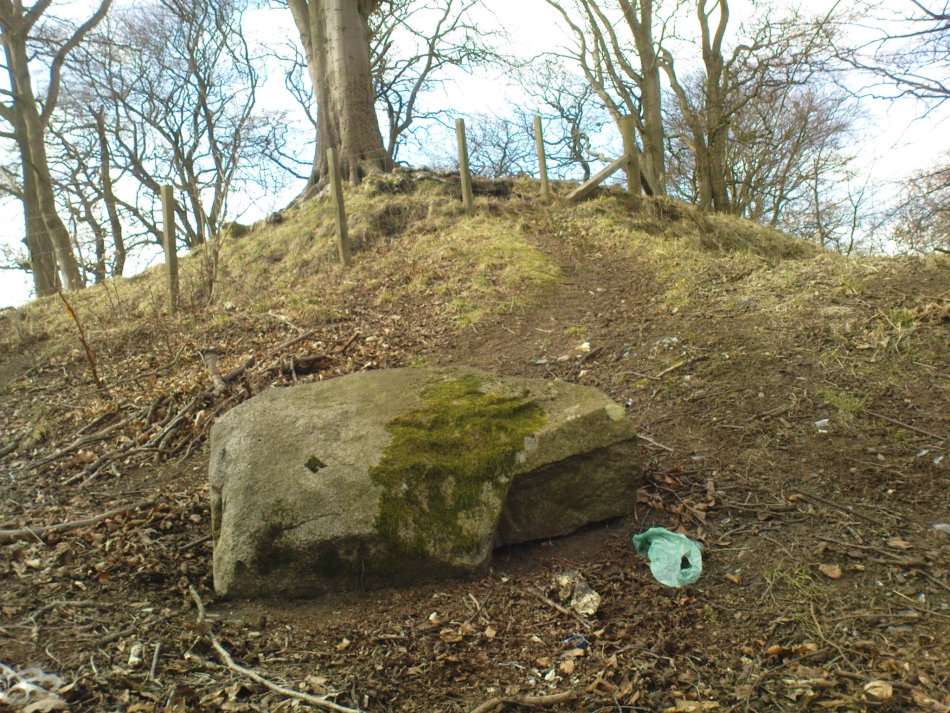
As you go through Pitlochry’s main street, watch out for the right-turn up the A924 road. Go up here for perhaps a mile. You’ll know you’re getting close as you pass the Moulin pub and the seeming avenue of trees opens on either side of the road. A coupla hundred yards up into the trees, there’s the left-turn up the Balnakeilly driveway. Stop! It’s on your left.
Archaeology & History
The Balnakeilly Monolith
Knocking on for nine-feet tall, there’s some debate as to the archaic authenticity on this standing stone. Ian Armit and his mate (1998) certainly wondered whether this was an ancient stone or not and, gotta say, when I came up here a coupla weeks back, I got the same impression. It doesn’t have that feel about it which comes from the real olde ones; but this could be due to it having been moved in the not-too-distant past. Though when Alan Reid wrote about it in 1911 he told us that,
“it bears marks of having been…worked slightly into shape by some pointed tool whose traces are plainly seen on several of its angles.”
Not something you’d find on monoliths that are a few thousand years old! But if this stone was moved when the entrance to Balnakeilly drive was done, or the road widened, this could account for such markings. We could do with digging into any archives that may exist about Balnakeilly or the Pitlochry roads to see if there’s any record of this stone to end the debate once and for all. Tis a good site to visit though – check it out!
Stone Circle (destroyed): OS Grid Reference – NS 9256 9709
Also Known as:
Druidical Temple
Archaeology & History
A stone circle was once to be found on the elevated piece of ground above the north-side of the main road between Tillicoultry and Dollar, but it was sadly destroyed sometime in the 19th century. Listed in Aubrey Burl’s (2000) magnum opus, we have very little information about the place; though an account of the site was described in the Scottish Royal Commission report (1933) which told us that a —
“Stone circle, measuring about 60 feet in diameter, once stood here but was completely removed many years ago, when the stones, which are said to have been 5½ feet in average height, were taken to cover a built drain at Tillicoultry House”!
Site shown on 1866 OS-mapStone at the destroyed site
Unbelievable! Any decent local folk nearby wanna find out where this drain is, see if the stones are visible (though I doubt they are), so we can plan to uproot it and move the stones back somewhere nearby. There are a few decent spots on the slopes above where it would look good!
When visited by researchers in the 1890s, parts of an embankment which surrounded the destroyed circle were still visible. Also, indicating there was some ritual funerary nature to the site, a local teacher called Mr Christie found the remains of an ornamented urn protruding through the ground next to where one of the monoliths had stood. Unfortunately in his attempts to remove the urn, much of it crumbled away.
Further examinations thereafter found that a burial was (seemingly) beneath the centre of the circle; and excavations here found that a covering stone of the tomb was covered in intricate cup-and-ring designs (see the Tillicoultry House Carving for further details). Other prehistoric remains were found a little further up the hill from here.
References:
Burl, Aubrey, The Stone Circles of Britain, Ireland and Brittany, Yale University Press 2000.
Morris, Ronald W.B., The Prehistoric Rock Art of Southern Scotland, BAR 86: Oxford 1981.
Robertson, R., ‘Notice of the Discovery of a Stone Cist and Urns at the Cuninghar, Tillicoultry…’, in PSAS 29, 1895.
Royal Commission on the Ancient & Historical Monuments of Scotland, Fife, Kinross and Clackmannan, HMSO: Edinburgh 1933.
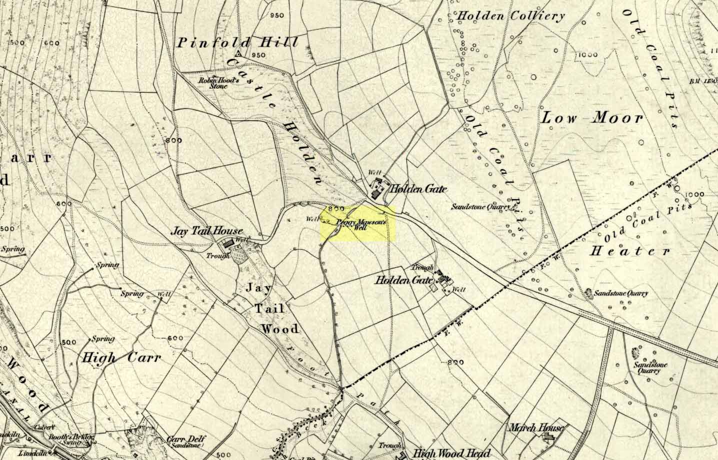
From Riddlesden, take the road up to the moorland and Rivock Edge. When you reach the top (Silsden Road), turn left. Go on for about 600 yards till you reach the lovely tree-hidden old cottages of Holden Gate, on your right. Stop — and walk down the footpath opposite from here. As the wall goes down, you’ll notice a stream in the next field to your left, emerging from a clump of large rocks. That’s it! (there’s a footpath in the next field from the roadside)
Archaeology & History
Shown on the first OS-map as ‘Peggy Mawson’s Well,’ little else seems to known of this place; though it obviously got its name after the local lady, Peggy Mawson. I can find no further information about this lady, nor why the site was named after her. Any help here would be hugely appreciated!
Peggy Mawson’s Well – now drained-off through pipes
Sadly the waters from beneath the rocks have been channeled into a couple of pipes and the well no longer runs. All that’s left is a small boggy region just in front of the boulders. You have to walk about 100 yards further down the field where the water emerges from a modern pipe. It doesn’t taste as nice as it originally did when coming straight from the ground, but it’s still quite drinkable (certainly beats any of the chlorinated stuff* that customers are forced to pay for, whether we want it or not – and most people don’t want it).
Folklore
This site has acquired modern folklore, but sadly no early traditions have been found. Whelan & Taylor (1989) thought that Peggy Well’s “dedication suggests a connection with St. Margaret,” which unfortunately isn’t the case. Several years later another writer, Val Shepherd (1994), spun the speculation even further, not checking the historical background to the site, and thought that “the well’s name may be derived from the water spirit, ‘Peg,’ who gave her name to other wells.” Sadly neither idea holds any sway.
References:
Shepherd, Val, Historic Wells in and Around Bradford, HOAP: Loughborough 1994.
Whelan, Edna & Taylor, Ian, Yorkshire Holy Wells and Sacred Springs, Northern Lights: Pocklington 1989.
* Anyone know about this: surely because the water companies chlorinate and add other undesirable toxins into our tap water, what we’re actually drinking is a very weak solution and not actually water. Isn’t that a trading standards violation?
From Durness take the road east for a couple of miles till you see the signpost which takes you on the left-hand side of the road, down to the coast. You can’t miss it!
Archaeology & History
Findings here allege to take the history of the place into the mesolithic period, but we don’t know this for sure. An excavation here by a Mr Donald Macdonald of Sangobeg in 1904 uncovered the presence of several small bone pins, which seem consistent with Mesolithic finds elsewhere. When archaeo-excavations were done here in 1982, human remains going back to at least Iron Age were found in the simple deposit of many shells. A further analysis by the Glasgow Archaeology Unit in 1996 was prevented of some excavation by (get this!) those screwy Health & Safety regulations. Here’s a definite case for an independent group to undertake work here, as we could ignore such preventative measures (and if we drown it’s our fault!). Smoo Cave’s primary function is pretty obvious: it would have been used for both shelter and ritual.
Folklore
The folklore here tells of magick and occultism and possible remnants of rites of passage lore. For herein, many centuries ago, a powerful land-owner called Lord Reay — reputed as a master in the black arts — battled with the devil in the Smoo Cave.
The devil was keeping watch on Lord Reay following a previous dispute between the two of them, and espied him as he entered the cave. As Alexander Polson told it, the cave
“consists of three caverns, one within the other. Lord Reay had got as far as the second, and his dog, which had gone on in advance, returned howling and hairless. By this, Lord Reay knew that Satan was there before him, and bravely waited the attack, which was soon made, and his lordship fought lustily. Happily at the opportune moment a cock crew. This frightened the devil and his attendant witches, but Lord Reay stood between them and the exit. In their fright they blew holes through the roof of the cave, and this is the origin of the two openings through which the Smoo burns fall.”
Pitch black cave; protective spirit animal; encountering one’s psychological nemesis; unconscious battles with Underworld forces; rebirth of the sun at cock-crowing time; the conquering of the dark forces and renewal of Lord Reay. These are typical hallmarks probably signifying folk-remnants of shamanism and rites of passage, for which this cave may once have been used.
References:
Polson, Alexander, Scottish Witchcraft Lore, W. Alexander: Inverness 1932.
Very close to being at the top of the island. If you do manage to get here take a gander at the legendary Gulf of Corryvreckan: one of the largest whirlpools on Earth, where the cailleach swirled her stuff when angry! This is the ‘hill where sorrel grows,’ and where George Orwell wrote 1984 – but more important for us is where the Royal Commission for Historic & Ancient Monuments of Scotland (Argyll, vol.5) designated that,
“a stony mound about 5.5m in diameter and 0.5m high, situated on the crest of the ridge east of Barnhill, appears to be a prehistoric burial cairn.”
Sadly I never managed to check this out when I was last up here as I didn’t know it was here!
References:
Royal Commission on the Ancient & Historical Monuments of Scotland, Argyll: volume 5 – Islay, Jura, Colonsay and Oronsay, HMSO: Edinburgh 1984.
Follow the same directions for getting to the Idol Stone, then walk just 30 yards further up the path and it’s the big rock on your left-hand side. Y’ can’t miss it!
Archaeology & History
Main section of cup-marks
This nice big boulder can be quite a temperamental chap, depending on how the light plays with the rock surface. I’ve got some photos of this old stone where you can see next to nowt on it; where as others show clearly aspects of the design that aren’t on the archaeo-images. But such is the nature of cup-and-rings I s’ppose!
Unlike its rather linear companion a few yards away, this great boulder has the more typical scattering of faded cups, lines and at least one cup-and-ring, etched with seemingly little purpose or structural design. But as we know, the very notion of structural design in forms consistent to modern mind-sets were anathema to the neolithic people who were etching these patterns on rocks. Indeed, even the notions of these images as ‘art’ as defined in modern times, has no relationship to the intrinsic reality of either cup-and-rings or reality per se, as experienced by our ancestors. And I think we find an explicit affirmation of this in the Cluster Stone here.
Close-up of cup-and-ring
Natural cuts in the rock have been heightened, for whatever reason, so that today the division between Nature’s marks and the mark of humans have become ambiguous as time has worn the features. The clustering of cup-marks on certain parts of the rock was surely indicative of (what we would term) separate events/forms, whose mythic relationship were, however, intrinscially related. This may be representative of a landscape map, or a series of events – but each would relate to one and other. But, of course, we truly don’t know, so think I’d best shut up!
Cluster Stone design (after Hedges 1986)
The carving itself, as we can see today, has perhaps as many as 40 cup-marks on it (Boughey & Vickerman safely vouch for 26), with five or six lines running across the surface, some of which have been modified by ancient peoples. The cup-and-ring on the stone is quite distinct. Neolithic or Bronze Age walling runs just a few yards away from here, but the precise line it takes has not been accurately assessed.
References:
Boughey, Keith & Vickerman, E.A., Prehistoric Rock Art of the West Riding, West Yorkshire Archaeology Service 2003.
Hedges, John (ed.), The Carved Rocks on Rombald’s Moor, WYMCC: Wakefield 1986.
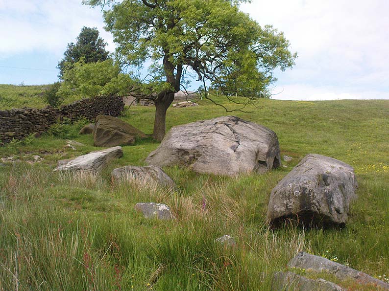
From Threshfield, go up Skirethorns Lane for about 1/2 mile, where the lane takes a sharp right. Continue uphill for nearly 2 miles to a metal gate. Go through the gate, where you’ll see a pair of curious standing stones ahead of you, but instead walk about 250 yards along the line of the old field wall running to the west. You’ll see on the modern OS-map that a ‘cairn’ is shown: this is where you’re heading!
Archaeology & History
First highlighted on the 1852 OS-map of Bordley and district, this is a lovely site in a beautiful setting, surrounded by a veritable mass of other prehistoric remains at all quarters, including the large settlement of Hammond Close immediately south, the little-known settlement at Kealcup to the west, the Lantern Holes settlement up the hill immediately north, some standing stones due east, and much more. Although it was described in Aubrey Burl’s Four Posters (1988) as just such a type of megalithic relic (a “four-poster stone circle”), an earlier description of the site from the mighty pen of Harry Speight (1892) told of a much more complete ring of stones, with trilithon to boot. He wrote:
“This prehistoric relic consists of a round stone and earthen mound, about 150 feet in circumference and 3 feet high, and was formerly surrounded by a circle of upright stones, only three of which are now left standing. On one side was a large flat stone resting upon two others, and known as the Druid’s Altar. On the adjoining land an ancient iron spear-head was found some years ago, and fragments of rudely-fashioned pottery have also from time to time turned up in the same neighbourhood.”
Edmund Bogg’s (1904) description following his own visit a few years later described this “remains of Druidical sacrifice” as consisting of,
“a mound some four feet high, and fifty yards round the outer rim. In the centre are two upright stones about four feet in length; and others nearly buried in the mound. Numerous stones from this circle have been used in building the adjoining walls.”
Bordley Circle, looking SEBordley Hill, looking south to Pendle Hill
A decade later another writer (Lewis 1914) merely copied what Speight and Bogg had recited previously. And whatever the modern books might tell of its status, I think we can safely assert that this was originally a much more substantial monument than the humble four-poster stone circle that meets our eye nowadays. Our megalithic magus, Aubrey Burl (1988), wrote the following on Bordley’s druidical stones:
“On a circular mound 41ft (12.5m) across and 3ft (1m) high, three stones of local limestone form the corners of a rectangle 11ft 6in (3.5m) square, from which the SW stone is missing. At its corner is ‘a stump, possibly the base of a prostrate stone,’ 5ft 10in (1.8m) long, now lying near the centre. The tallest stone, 3ft 7in (1.1m) high is at the south-east. The sides of the square are close to the cardinal points. Between the SW and SE stones is a scatter of round cairnstones… Characteristically, the 4-Poster stands at the edge of a terrace from which the lands falls steeply to the west.”
Plan of the Druid’s Altar (after Burl, 1988)
The Druid’s Altar seems to have originally been a large prehistoric tomb, perhaps even a chambered cairn. Its situation in the landscape where it holds a circle of many outlying hills to attention, almost in the centre of them all, was evidently of some importance. The only geographical ‘opening’ from here is to the south, where a long open valley widens to capture the grandeur of Pendle Hill, many miles away. This would not have been insignificant.
We must also draw attention to what may be a secondary tumulus of similar size and form to the mound that the Druid’s Altar sits upon only some 25 yards to the west of the “circle”. The shape and form of this second mound is similar to that of our Druid’s Circle — though to date, it seems that no archaeologist has paid attention to this secondary feature. It measures some 21 yards (east-west) x 19 yards (north-south) in diameter and has the appearance of a tumulus or buried cairn. The mound may be of a purely geological nature, but this cannot safely be asserted until the attention of the spade has been brought here.
Druid’s Altar, Bordley (drawing by Neil Wingate, 1976)
Folklore
Although we have nothing directly associated with the circle, the surrounding hills here have long been known as the abode of faerie-folk. Threshfield — in whose parish this circle lies — is renowned for it. There have been accounts of curious light phenomena here too. Modern alignment lore tells the site to be related to the peaked tomb above Seaty Hill, equinox west of here.
References:
Bogg, Edmund, Higher Wharfeland, James Miles: Otley 1904.
Burl, Aubrey, Four Posters: Bronze Age Stone Circles of Western Europe, BAR 195: Oxford 1988.
Feather, S.W. & Manby, T.G., ‘Prehistoric Chambered Tombs of the Pennines,’ in Yorkshire Archaeological Journal, Vol 42, 1970.
Lewis, A.L., ‘Standing Stones and Stone Circles in Yorkshire,’ in Man, no.83, 1914.
Raistrick, Arthur, ‘The Bronze Age in West Yorkshire,’ in Yorkshire Archaeological Journal, Vol 29, 1929.
Speight, Harry, The Craven and Northwest Yorkshire Highlands, Elliott Stock: London 1892.
Wingate, Neil, Grassington and Wharfedale, Grassington 1977.
Cairn (destroyed): OS Grid Reference – NO 2738 4885
Archaeology & History
Unfortunately we can no longer see the large prehistoric tomb that was once visible in the fields here, close to the bottom corner of the field below the old Bridge of Ruim, a couple of hundred yards north of the A926 road to Ruthven. The site was destroyed around 1863, but records show that there were several burials found here containing human bones, along with an urn. Described in an early PSAS article, the Scottish Royal Commission chaps seemed to think that “its position may be indicated by a low swelling in the field”, about 30 yards southeast of the position shown on the first OS-map. Anyone know owt more about this place?
References:
Royal Commission on the Ancient & Historical Monuments of Scotland, North-East Perth: An Archaeological Landscape, HMSO: Edinburgh 1990.
Cairns (destroyed): OS Grid Reference – NT 2447 6828
Archaeology & History
Not far from the giant cup-marked Caiy Stone, there used to be two very large prehistoric cairns, which local historian Daviid Shankie told us “were foolishly broken up by some sacriligious hand and used for road metal”! Not good… Remains of human bones and several fragments of old weapons were found in them. Fred Coles (1903) told us that:
“In the neighbourhood of this [i.e. Morton Hall], but further southwest, on the grounds of Comiston, were found, in forming the public road, under large heaps of stones, various sepulchral stone enclosures, in which were deposited urns with dead men’s ashes, and divers warlike weapons.” And again, when speaking of the levelling of a part of the ground close to the old (so-called Roman) road, by Sir John Clerk of Pennycuick, the same writer adds, there ” were discovered several stone coffins with human bones.”
Folklore
According to Shankie (1902), these two great cairns were built upon lands previously known as the Templelands of Swanston and commemorated a great battle that was fought “between the ancient Picts and Scots.”