Cup-and-Ring Stone (lost): OS Grid Reference – SE 0965 4797
Archaeology & History
In Ronald Morris’ (1989) gazetteer of British petroglyphs, he included this curious entry but gave no real details regarding its appearance or history. Listed by the Royal Commission lads, it would seem to have been located immediately south of the dismantled railway where it used to cross the Addingham-Ilkley road, but no one seems to have seen it either before or since Morris’ description. Any help regarding its whereabouts would be appreciated.
References:
Boughey, Keith & Vickerman, E.A., Prehistoric Rock Art of the West Riding, WYAS: Wakefield 2003.
Morris, Ronald W.B., “The Prehistoric Rock Art of Great Britain: A Survey of All Sites Bearing Motifs more Complex than Simple Cup-marks,” in Proceedings of the Prehistoric Society, volume 55, 1989.
Cup-and-Ring Stone (lost): OS Grid Reference – NT 269 419
Also Known as:
Kittlegairy Burn
Archaeology & History
Fred Coles’ 1898 sketch
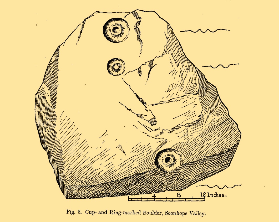
An apparently isolated cup-and-ring stone was found on the hills north of Peebles at the end of the 19th century by the renowned Scottish megalith explorer, Fred Coles. (1899) He was having a look at some of the hillforts in the area and—as some of us tend to do—he began meandering off-track, down streams, through bogs and as a result came across the carving that’s illustrated here. It’s subsequently become “lost” in the hills, but it shouldn’t be too difficult to locate, as the description he gave of its whereabouts is a pretty good one. He told us:
“A very little over one mile and a quarter up the valley, measuring from the road at Kerfield Cottage, a tiny rivulet called Kittlegairy Burn trickles down from the SE into the main stream. On the hill to its east, and about 450 feet higher, are the remains of a fort, one of a series of three crowning prominent heights along this side of the valley. Down the main stream from Kittlegairy Burn is a large ruined sheep-shelter called Soonhope. Nearly midway between these two points a deep curve has been hollowed out of the E. bank; and, at the foot of this rather high gravel bank, half immersed in the stream, lies the block of stone with the cup-and ring-marks. They were discovered, 14th September 1896, by my daughter, Helen, on crossing the stream; and we at once proceeded to make a measured drawing, a reproduction of which is given here…. The depth of the rings in proportion to their width is the one most noticeable feature; next, the extreme thinness of the intervening ‘neck’; but, on a minute and careful examination of the nature of the stone itself, taking into consideration that its angularity and sharpness of edge and the absence of moss or even of confervoid growths on its surfaces went against the possibility of its being truly waterworn.”
The rock had obviously fallen from its original position above the burn. Today, the entire area where this stone exists has been covered by a huge forestry plantation, but if any rock art fanatics from the Peebles area get bored one day and have nothing to do…..
References:
Coles, Fred, “Notices of the Discovery of a Cist and Urns at Juniper Green, and of a Cist at the Cunninghar, Tillicoultry, and of some Undescribed Cup-marked Stones’, in Proceedings Society Antiquaries, Scotland, volume 33, 1899.
Morris, Ronald W.B., “The Cup-and-Ring and Similar Early Sculptures of Scotland; Part 2 – The Rest of Scotland except Kintyre,” in Transactions of the Ancient Monuments Society, volume 16, 1969.
Cup-and-Ring Stone (removed): OS Grid Reference – NT 807 659
Archaeology & History
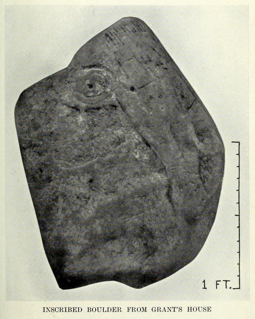
A carving that no longer exists in its place of origin, but can now be seen in the National Museum of Antiquities in Edinburgh. It was discovered by a Mr James Craw (1931), who gave us the following account of his find:
“In 1910 my attention was attracted by some markings on a boulder on the top of a field wall, ¼-mile NNW of Grant’s House church and at an elevation of some 550 feet above sea level. The stone was a rounded and somewhat flattened slab of greenstone, measuring 22 inches by 17 inches by 4 inches… It bore a small cup ½-inch in diameter, surrounded by two rings of shallow incision, the outer being 3 inches in diameter. From the cup a duct, partly natural, led across the stone, and another cup, without rings, had also a short duct. Adjacent to these markings was a curious grid design of shallow lines, a series of parallel lines ¼-inch apart, being crossed at right angles by lines 2½ inches apart.”
1930 photo of the carving
Across a section of the stone there may also be a curving pecked line which Craw didn’t appear to notice. The parallel lines would appear to have quite separate origins, with those running below the cup-and-ring seeming to be ancient, whereas the others have the appearance of being cut with metal tools and seem much more like modern scarring.
Shortly after finding the stone, Mr Craw took the petroglyph to the National Museum in Edinburgh, where he was told that they didn’t think it “as being of early workmanship, the cups and rings being of much smaller proportions than the typical markings of the Bronze Age and the grid design having no known parallel.” They were wrong on both accounts of course, although I for one still remained unconvinced by one set of parallel lines that run along to the edge of the stone. That said, there are similar carvings of parallel lines at the impressive Traprain Law 15 miles northwest of here, so I may be wrong.
The wall in which this carving was found was obviously not its place of origin. It most likely came from one of the cairns that was reported by J. Hardy to have been destroyed in this field in 1882.
References:
Craw, James H., “An Inscribed Boulder from Grants House,” in History of Berwickshire Naturalists Club, volume 27, 1931.
Edwards, Arthur J.H., “Rock Sculpturings on Traprain Law,” in Proceedings Society of Antiquaries, Scotland, volume 69, 1935.
Morris, Ronald W.B., “The Cup-and-Ring and Similar Early Sculptures of Scotland; Part 2 – The Rest of Scotland except Kintyre,” in Transactions of the Ancient Monuments Society, volume 16, 1969.
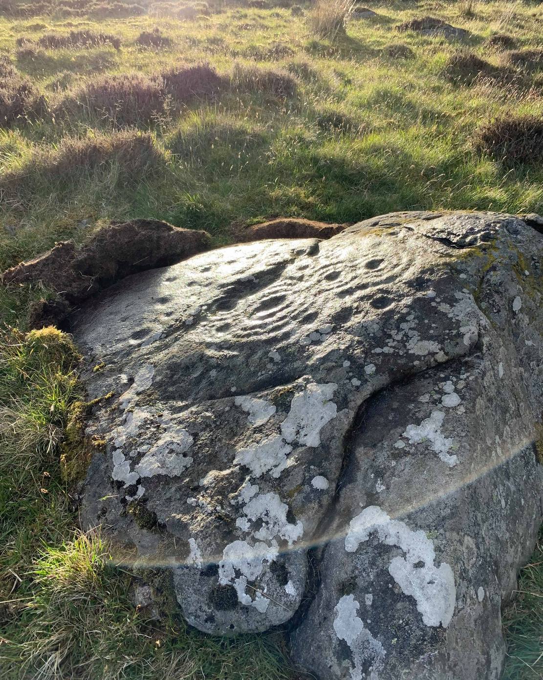
Two ways: i) up the A93 road from Blairgowrie, after 5 miles turn right at the Bridge of Cally and up Glen Shee. After another 3½ miles, keep your eyes peeled for the tiny road on the right signposted to the Drumturk Cheese farmshop. Go up this long tiny winding road for a mile up to the cheese place and keep on this road for another 2¼ miles where you can park up near the entrance to the huge wind-farm; or – (ii) from Alyth, go up the long winding tiny Bamff Road and keep to the signposts for Bridge of Cally Glen Shee until, after about 4 miles, you reach the entrance to the windfarm. Walk up the track to the windmills, bearing right at the first junction, then right again at the next one. From here, shortly before the second windmill, walk down into the moor for nearly 200 yards. It’s quite a large stone.
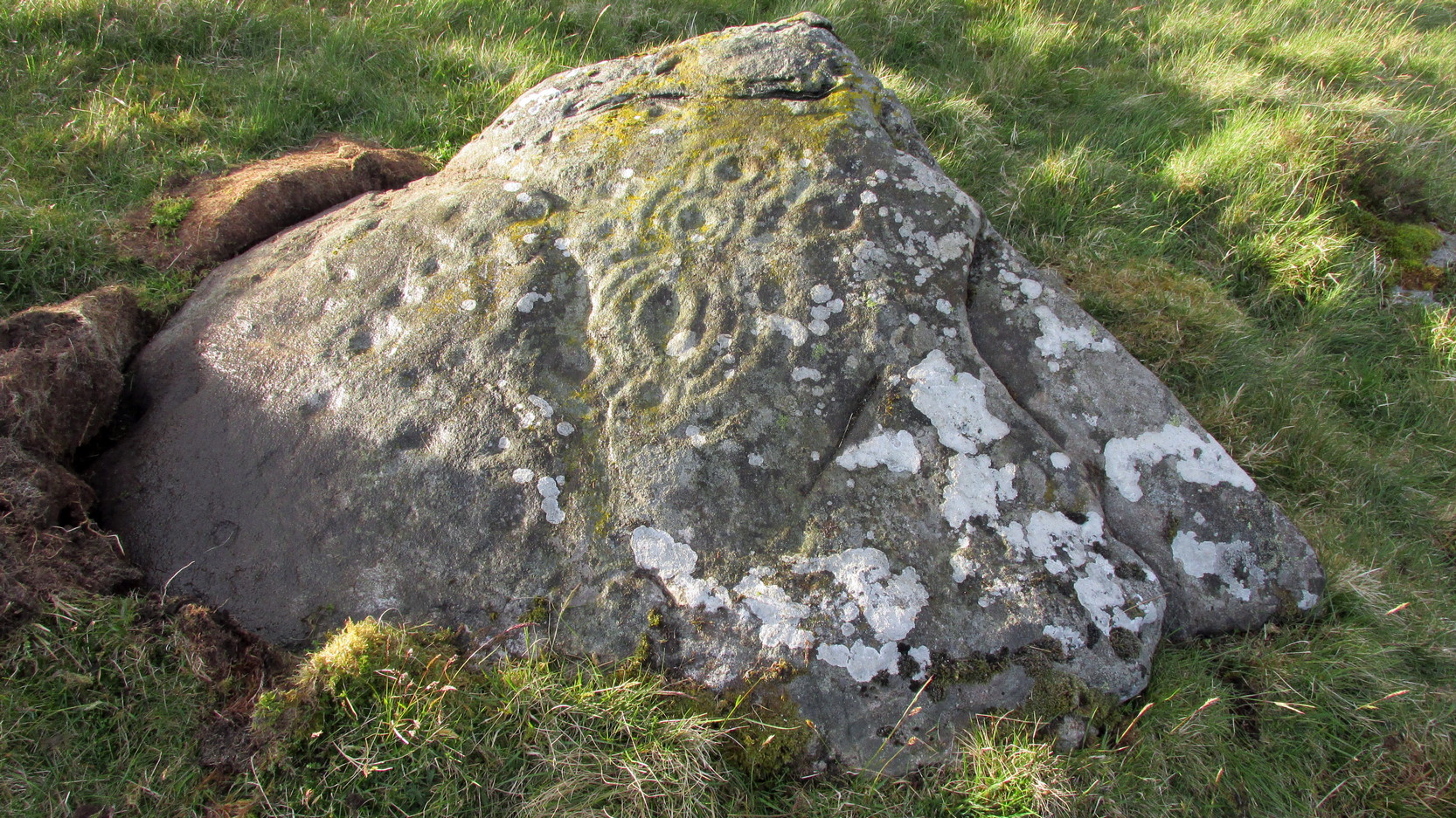
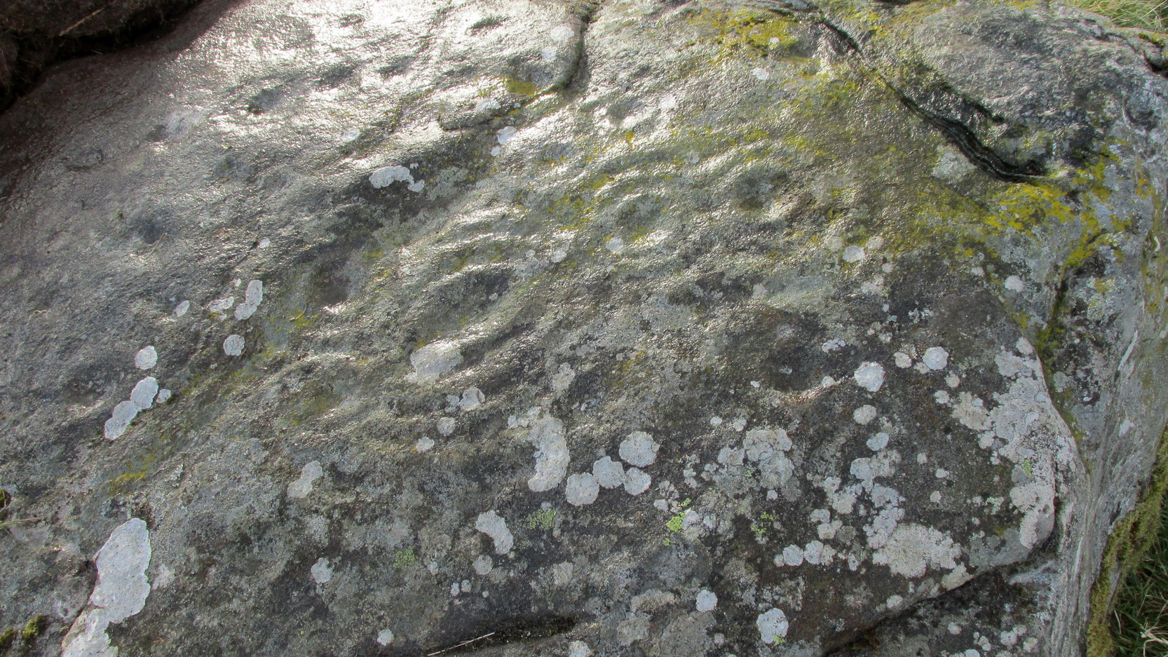
Archaeology & History
Interlocking rings close-up
This is impressive. Very impressive! Found within a huge mass of other prehistoric sites in the Forest of Alyth, its only known petroglyphic bedfellows—Drumderg (1) nearly 500 yards yards south, and Drumderg (3) 120 yards north—have nothing on this one! Where the others have basic cupmarks, this bears a series of multiple interlocking cup-and-ring designs, some with one ring, others with two, and one with four, albeit incomplete rings.
The design is etched onto the sloping face of a curved triangular ‘female’ stone. An eroded cutting all but separates the two main components of the design, but this cut has within it a distinct singular cup-and-ring almost linking each side together. On one side (which is near the middle of the stone) we have a complex series of multiple cup-and-rings that seem to be sequentially moving and (almost) growing into each other in some form of organic pattern. The bottom of this growth begins from a standard cup-and-ring and runs immediately into a vulva-like slit of a cup-mark surrounded by four incomplete rings. As the photos show, this keeps climbing upwards.
Cupmarks on its W-sideLooking into the setting sun
A more simplistic basic design has been etched onto the more western side of the stone, on the other side of the eroded cutting. Two of the cup-marks have rings around them, with one of them seeming to give birth to another upward “growth”, but this time comprising merely of a line of more cups, curving ever-so-gently towards the middle of the stone. Along with this there are also cup-marks on the top ridge of the stone; faint carved lines curve and intersect. Movement seems embedded in this fixed non-linear design. That’s my impression anyhow!
The only literary attention given to the carving seems to have been by the Scottish Royal Commission (1990) lads in one of their Perthshire inventories. It’s simple as always, telling basically,
“this heavily weathered cup-and-ring marked boulder lies 150m south of the hut circles… The carvings are on the southwest face of the boulder and comprise: at least four cups surrounded by single rings; two cups surrounded by triple rings; an oval cup measuring 100mm by 70mm surrounded by four rings; and twenty-two plain cups marks, the largest 60mm in diameter.”
If there’s anything extra that we should puzzle over, it’s this: why do we have such an intricate carving here, living in near isolation in the midst of countless other prehistoric remains? The answer, most likely, is that it’s not alone. I highly suspect that others are waiting to be found up here beneath the endless ocean of heather…
References:
Royal Commission on the Ancient & Historical Monuments of Scotland, North-East Perth: An Archaeological Landscape, HMSO: Edinburgh 1990.
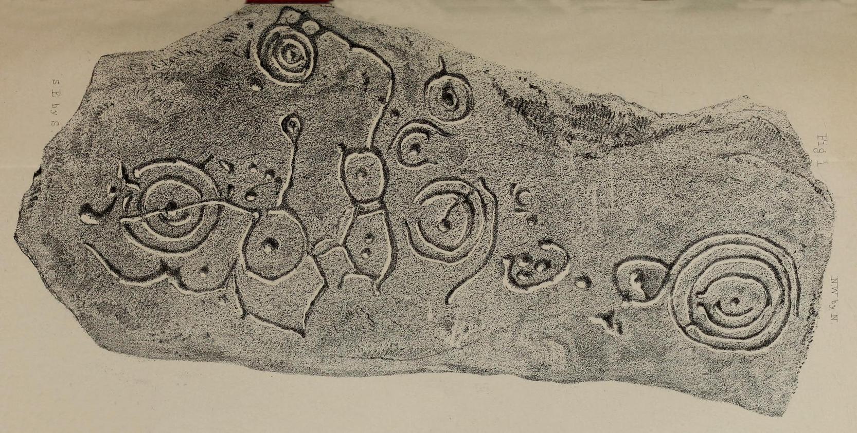
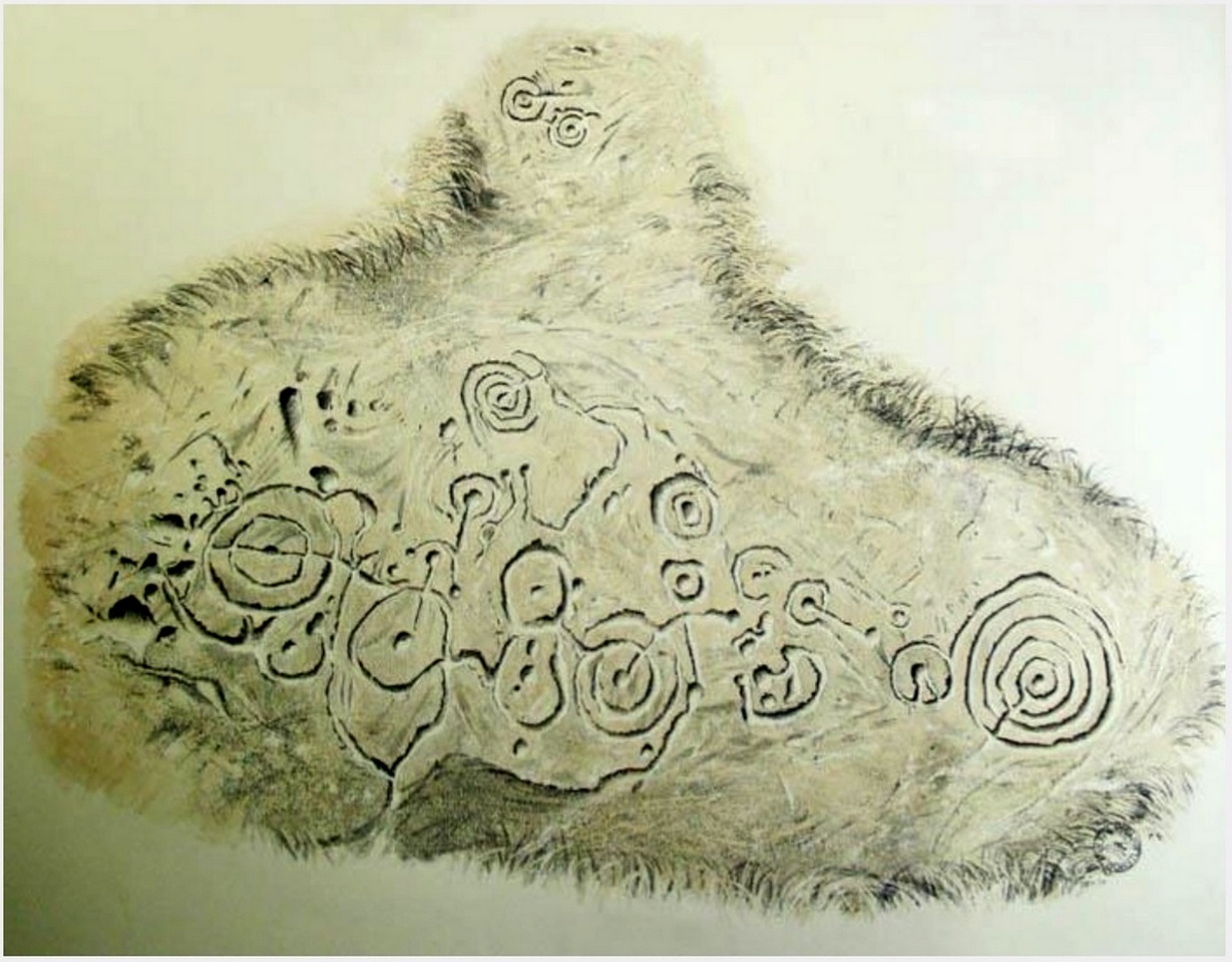
In 1863, a bunch of reputable Victorian authors and antiquarians met with the Duke of Northumberland in Alnwick Castle to discuss the matter of making decent images of the petroglyphs which, at the time, had only just been rediscovered in the area. At one of their meetings, the floor in one of the Castle rooms was covered with rubbings of carvings that they’d made—this one included. I’d loved to have been there! Subsequently, from that meeting, sketches of this carving were done and included in the works by George Tate (1864; 1865) and then a few years later in J. Collingwood Bruce’s (1869) rare tome that had been published with the help of dosh from the Duke.
Found along a raised geological ridge running roughly east-west, a number of other carvings are close by and well worth looking at when you visit here. The basic (and first) description of the site by Tate told that here,
Tate’s 1864 sketchJ.C. Bruce’s 1869 image
“on a high ridge on Hunter’s Moor, a large surface of rock, some forty yards by twenty, having a gentle slope to the northward, is partially uncovered. In one part, which has been entirely cleared of turf, fourteen figures are scattered over an area of 15 feet by about from 5 to 7 feet. Some of the figures are of the common type, one of which is 28 inches in diameter; but others present new features; and several are curiously united by straight and curved grooves. Across the entire diameter of a group of four concentric circles, runs a groove connecting them with other combined figures. An irregularly shaped, rounded, angular figure, encloses two hollows or cups; and united to this is a broad oval figure. One figure around four cups approaches to the reniform.”
When the modern rock art expert Stan Beckensall wrote about this site, he mentioned how his own picture of the carving consisted of a number of elements that weren’t included by the 19th century pioneers—which isn’t unusual.
References:
Beckensall, Stan, Northumberland’s Prehistoric Rock Carvings – A Mystery Explained, Pendulum: Rothbury 1983.
Beckensall, Stan, Prehistoric Rock Motifs of Northumberland – volume 1, Abbey Press: Hexham 1991.
Bruce, John Collingwood, Incised Markings on Stone; found in the County of Northumberland, Argylshire, and other Places, privately printed: London 1869.
Tate, George, “The Ancient British Sculptured Rocks of Northumberland and the Eastern Borders,” in Proceedings of the Berwickshire Naturalists Club, volume 5, 1864.
Tate, George, The Ancient British Sculptured Rocks of Northumberland and the Eastern Borders, Henry Hunter Blair 1865.
Cup-Marked Stone (lost): OS Grid Reference – SO 1491 0045
Archaeology & History
Sometime in the 1940s, a certain Lady A. Fox recorded a cup-marked stone “in the vicinity of Pen-twyn” near Bargoed. Its position in the landscape is a good one: on a geological promontory and overlooking the valley below. The find was indexed by the Ordnance Survey, but apart from it’s grid-reference, all attempts to locate the design have so far proved unsuccessful.
It was mentioned briefly in the Royal Commission (1976) survey of Glamorgan, then subsequently listed in the surveys of Sharkey (2004) and Nash (2007), but none of them were able to locate it. And hence, I post it here, in the hope that some local hunter will be able to recover it from its hiding place!
References:
Mazel, A., Nash, G. & Waddington, C. (eds.), Art as Metaphor: The Prehistoric Rock Art of Britain, ArchaeoPress: Oxford 2007.
Nash, George, “A Scattering of Images: the Rock Art of Southern Britain,” in Art as Metaphor, ArchaeoPress: Oxford 2007.
Royal Commission on the Ancient & Historical Monuments, Wales, An Inventory of the Ancient Monuments in Glamorgan – Volume 1: Pre-Norman, Part 1: The Stone and Bronze Ages, HMSO: Cardiff 1976.
Sharkey, John, The Meeting of the Tracks: Rock Art in Ancient Wales, Gwasg Carreg Gwalch: Llanrwst 2004.
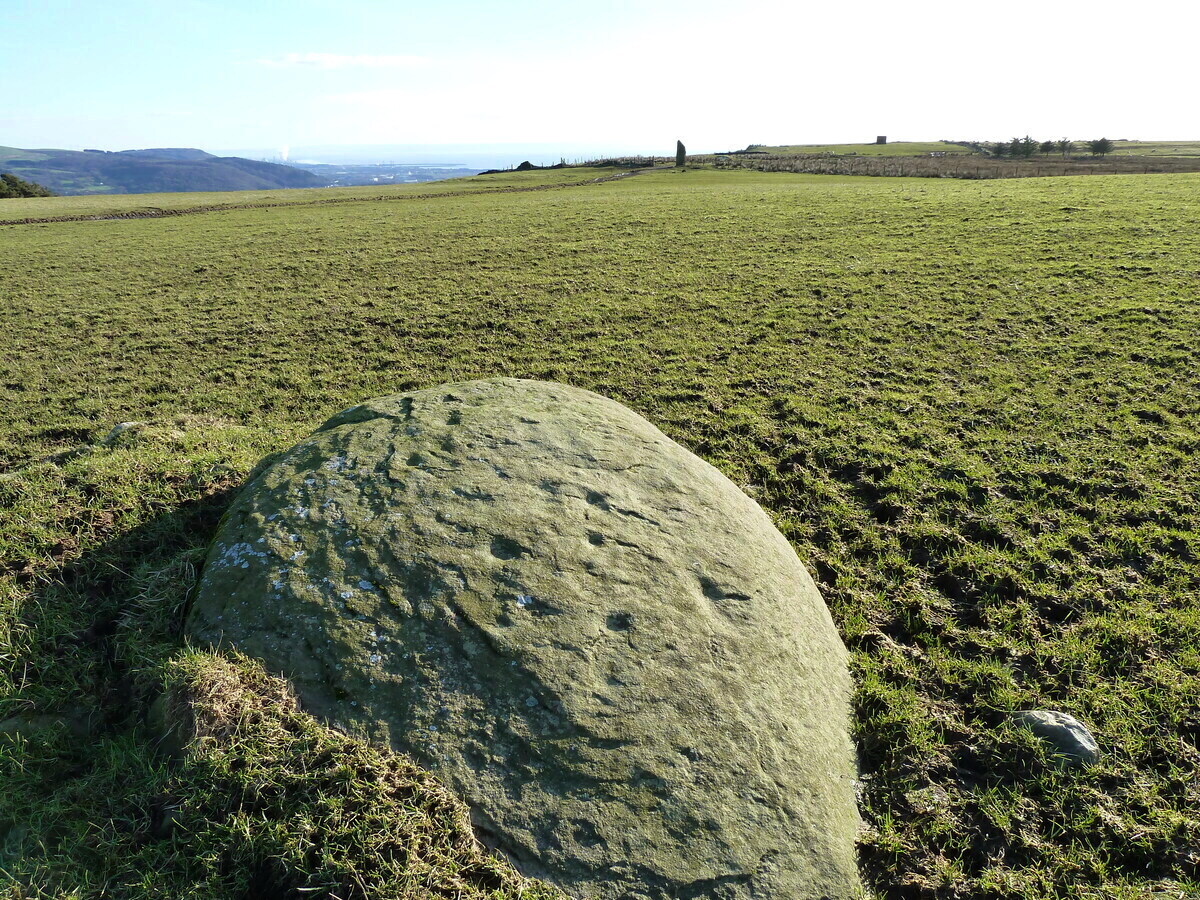
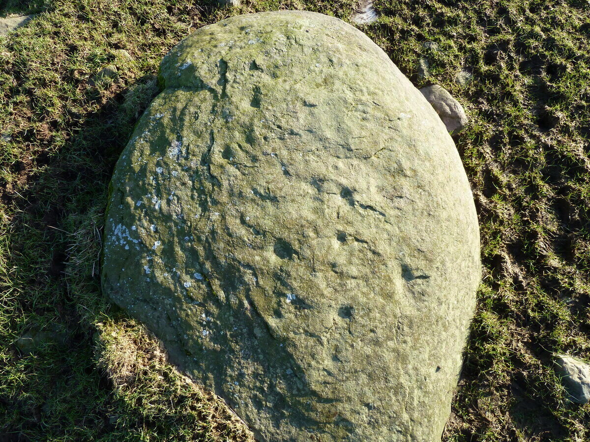
An interesting new cup-marked stone found by Paul Blades is this smooth rounded (female) stone that may originally have had some relationship with the tall standing stone of Careg Bica 160 yards to the south. Around ten cup-marks are etched onto its surface, in a seemingly random arrangement (as usual!). Although it seems to be an isolated carving, it’s likely that others will exist in the area.
Carving & outlying monolithCareg Bica petroglyph
The direction and proximity of the standing stone may have had some relationship with the carving. In traditional northern hemisphere societies, the cardinal direction North is generally associated with darkness and death, primarily due to the fact that this is the area in the heavens where neither sun or moon ever appear; whilst South relates to life and positive natural associations due to it being the high point of the sun during the day. This animistic attribute existed till recently in the water-lore of northern England and Scotland where “south-running streams bore a high repute.” Whilst such mythic attributes are well established, any cardinal relationship here is purely speculative.
Acknowledgements: Huge thanks to Paul Blades for use of his photos in this site profile – and of course for finding the stone!
Follow the directions to reach the Ancestors’ Stone and the Sunrise Stone; and there, roughly halfway between them, right by the edge of the old collapsed walling, you’ll see this rise of a stone with a large ‘bowl’ on top. That’s it!
Archaeology & History
Mixing Stone, looking E
Laid upon the same geological ridge as our Ancestors’ and Sunrise carvings, there are one, possibly two faint cup-marks visible on the low flat surface near the edge of this rock, barely visible unless the light’s right. But the important element here, perhaps regardless of the cup-marks, is the ‘bowl’ or rock basin on top of the stone. Internally, it’s smoothed equally on all sides and, due to being in-between the two impressive petroglyphs, may well have had a practical function to it. Bear with me on this one…
The Mixing Stone’s bowl
Stone ‘bowls’ or cavities—natural and otherwise—have been made use of in many cultures for simple functional purposes, such as grinding flour, herbal mixes, etc. We find such traditions in some of the bullauns of Ireland and Scotland; whereas in similar stone bowls known as cat troughs in nearby Haworth, milk was poured to appease the spirits of the land (this tradition was still being maintained in 2001!). Folklore and traditions of such rock basins spread far and wide beyond the UK: one of the German terms for rock basins is Opferkessel, meaning ‘sacrificial basin’ and suggests ritualistic usage by early societies. Elsewhere on Earth there are numerous accounts of the ritual use of petroglyphs in which indigenous peoples tell of their use of plant- or rock-based paints (in many cases red ochre) to decorate the carvings. And it’s this element that I’m interested in here.
Water-painted cupmarks
The Sunrise and Ancestors’ Stones 10-15 yards either side of this Mixing Stone are ideal candidates for such petroglyphic paintings using early ochre and other stone or plant-based agents. Such activities would always have been ritualised, either in honour of ancestors, genius loci, calendrical rites, or whatever the pertinent ingredient was at that place and time. I’m suggesting simply that the rock basin on the Mixing Stone was used for just such purposes. This is no spurious suggestion, but at the same time it’s important to recognise that my thoughts here represent merely an idea, nothing more—not a fact. Whilst we know full well that these carvings were imbued fundamentally with animistic properties—a simple ‘fact’—this functional idea is just that—an idea. Students and petroglyph-nuts need to understand this. And the faded cup-marks at its edge are perhaps merely incidental…. though I don’t buy that misself!
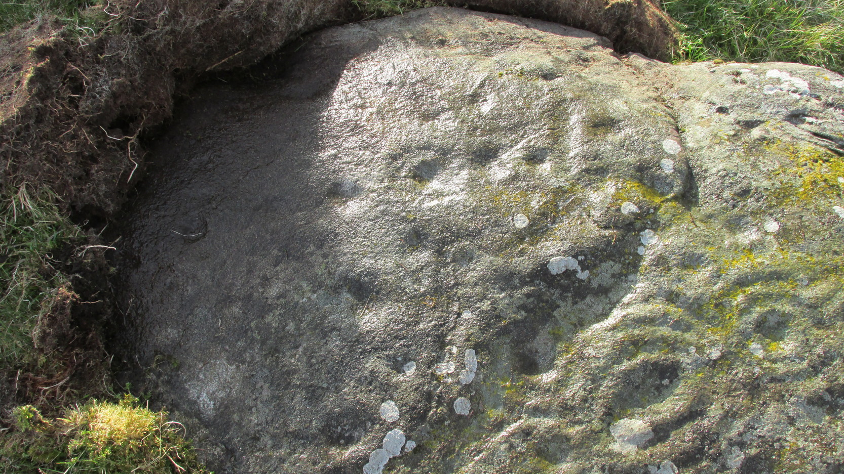
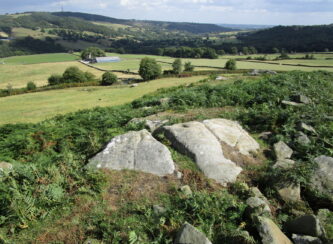
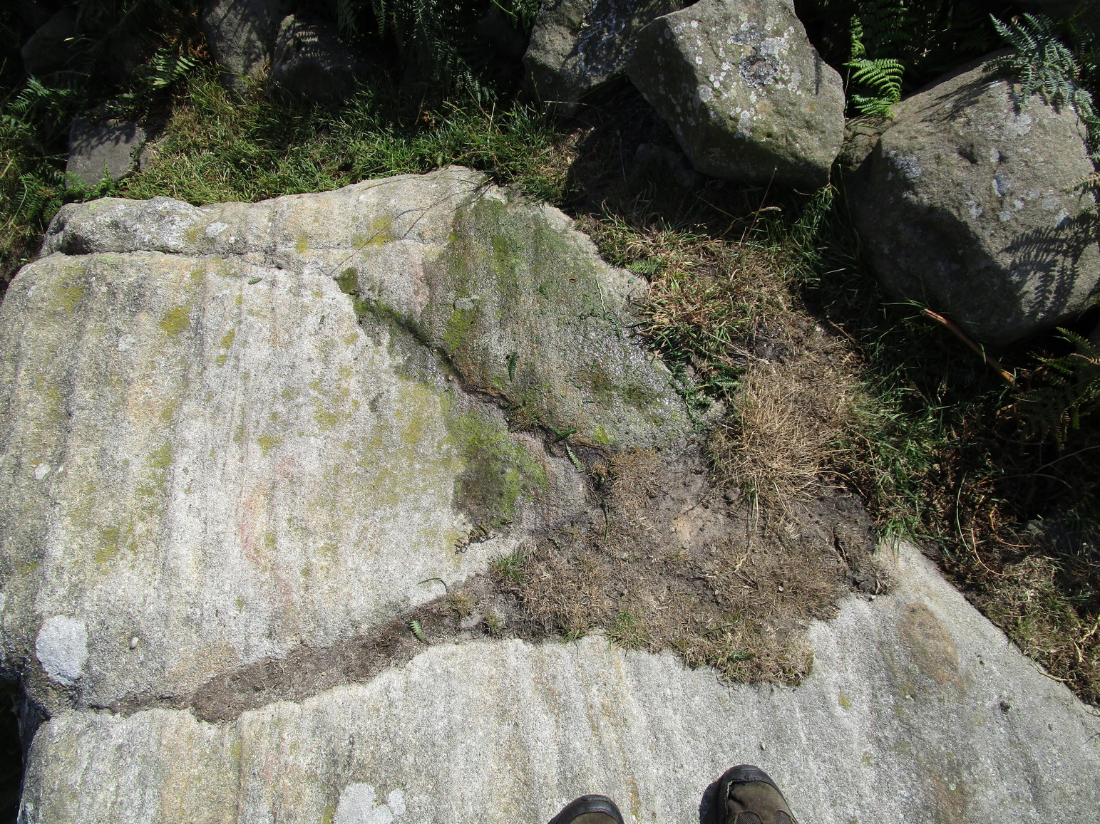
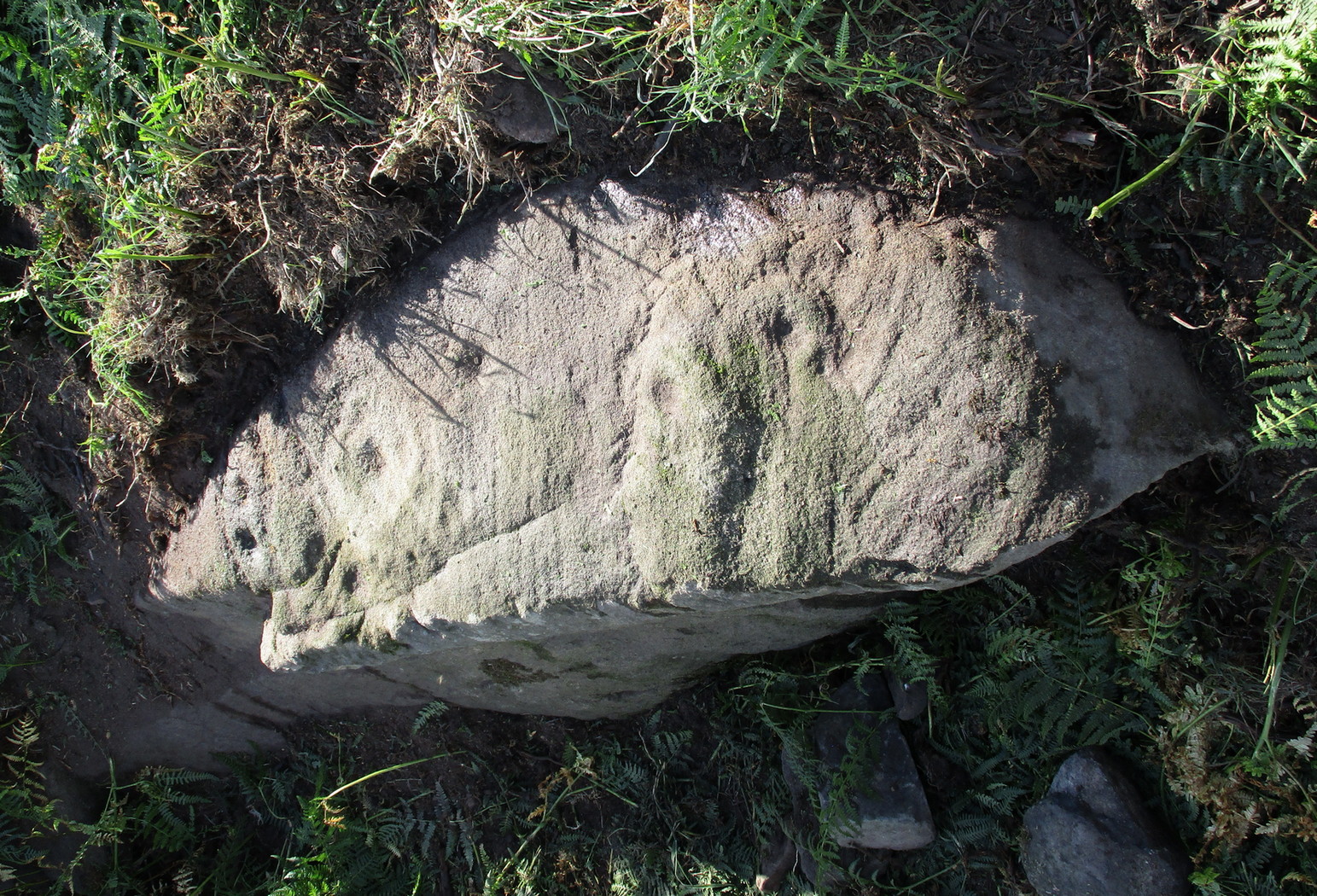
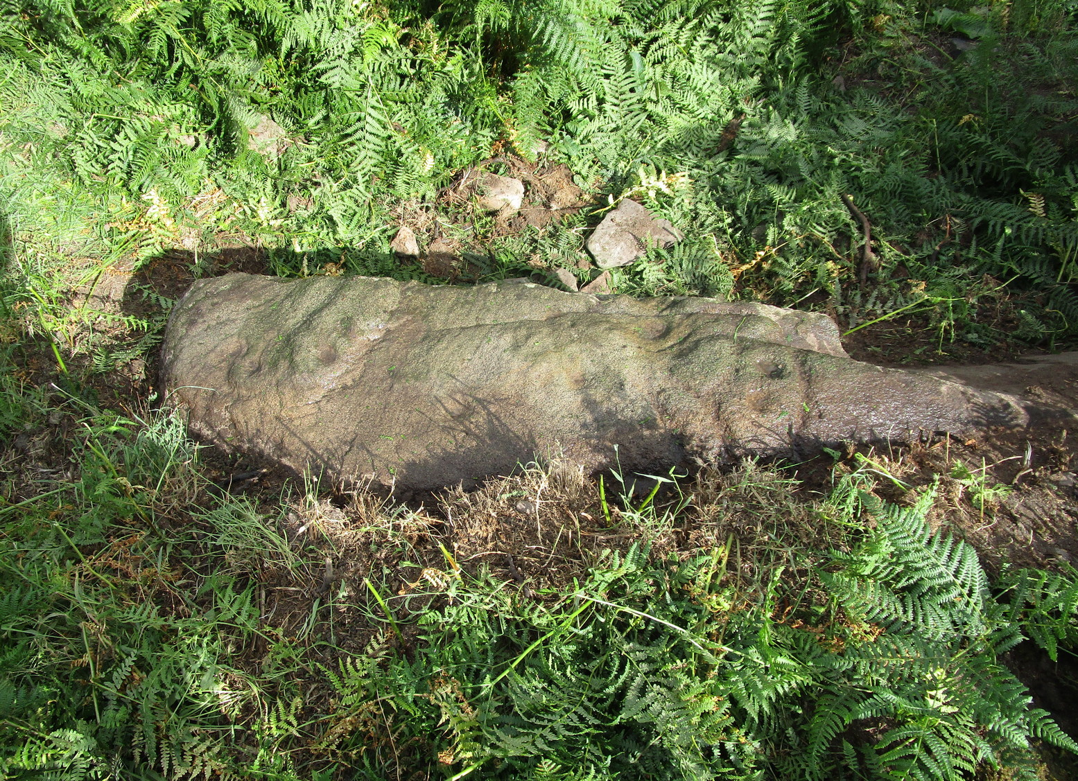
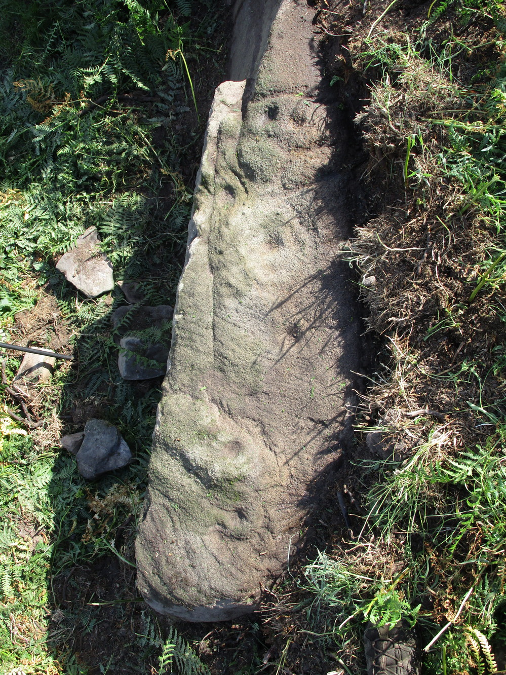
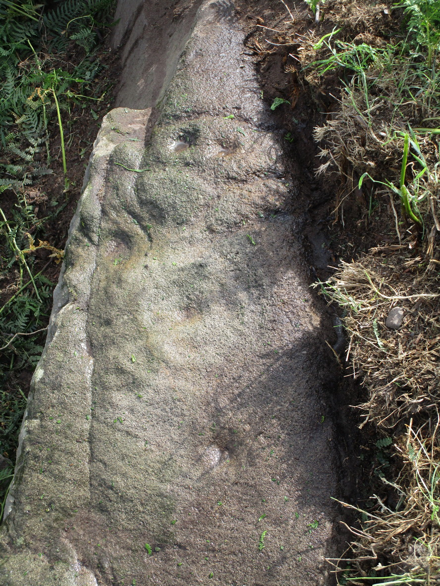
If you’re coming up from Otley or Askwith, take the same directions as if you’re going to visit the impressive Naked Jogger Carving (stone 612), not far from the well-known Tree of Life Stone. From the Naked Jogger carving, walk up to the small outcrop of rocks that bends above you. There’s a small collapsed line of walling just behind the outcrop. Walk along this up the slope as if you’re heading for the Sunrise Stone carving, but only 30 yards along, low down and right into the edge of the wall itself, you’ll see this elongated piece of stone. That’s the spot!
Archaeology & History
If you’ve caught the petroglyph-bug, you’ll like this one! It received its name from the curious fusion of natural cracks with the man-made pecked lines that shows, quite distinctly when the light is right and the stone is wet, the outline of two humanesque forms joined to each other. Figurative rock engravings of ancestors in the UK are extremely rare and when we came across this example, we noticed how the design could be interpreted as two Askwith Moor ancestor figures. Figurative rock art images elsewhere in the world such as the magnificent Wandjina paintings and the extensive galleries of figures engraved at Murujuga (Burrup Peninsula) in Western Australia, might provide an initial comparison, though more specific work needs to be done to better understand this unique petroglyph.
Sketch of the carving
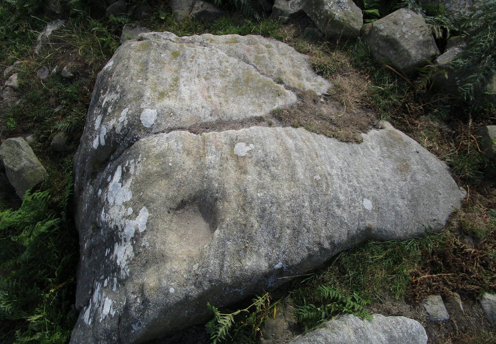
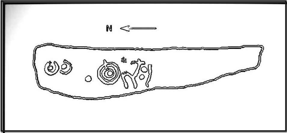
You can almost make out the figures in the above photo: the upper torsos of two beings on the right-hand side of the rock, almost fused together. And the carved shapes of these “ancestral beings” are morphically similar to some elements in the Sunrise Stone just 50 yards away – which themselves remind me of a Northumbrian carving near Doddington known as West Horton 1a. (Beckensall 1991) But we should’t get too carried away by the idea because—as we can see here in the sketch of the carving—when looked at from a different angle above, we could infer the right-hand carved elements to be representative of an animal: a deer, perhaps. Rorscharch’s once more tickle the exploring mind….
The rock has been quarried into at same time in the past (just like the nearby Sunrise Stone), leaving us to wonder what the complete carving might have looked like. No doubt some pieces of it will be in the collapsed walling either side of the stone. All we have left to see are the two unfinished cup-and-rings above the natural cracks that give rise to the “ancestral being” appearance. The faint double cup-and-ring has curious linear arcs to its side, with two well-defined cups enclosed by two of them. It’s a nice-looking carving when the light is good. The petroglyph was carved over a long period of time, as evidenced by the differing levels of erosion in different sections of the design. It’s a common attribute. The oldest section is the faint double cup-and-ring, whose mythic nature was added to / developed at a much later date, perhaps even centuries later.
In the always-expressive archaeocentric description of Boughey & Vickerman’s (2003) otherwise valuable tome, they told this carving to be,
“Long, narrow, thick rock of medium grit. Six cups, one with a double ring with a tab out and two with at least partial single rings, grooves.”
Evocative stuff!
It’s very likely that this carving had some mythic relationship with its close neighbours either side of it, probably over a very long time period and I’m inclined to think it somehow related to the rising of the sun, just like its solar companion further up the slope. Please note how I emphasize this ingredient in the site profile of its neighbour, the Mixing Stone 10-15 yards away—roughly halfway between this and the Sunrise Stone. A distinct place of ritual was happening in this close-knit cluster of carvings…
References:
Beckensall, Stan, Prehistoric Rock Motifs of Northumberland – volume 1, 1991.
Boughey, Keith & Vickerman, E.A., Prehistoric Rock Art of the West Riding, WYAS: Leeds 2003.
Reeder, Phil, “Snowden Carr Rock Carvings,” in Northern Earth Mysteries, no.40, 1990.
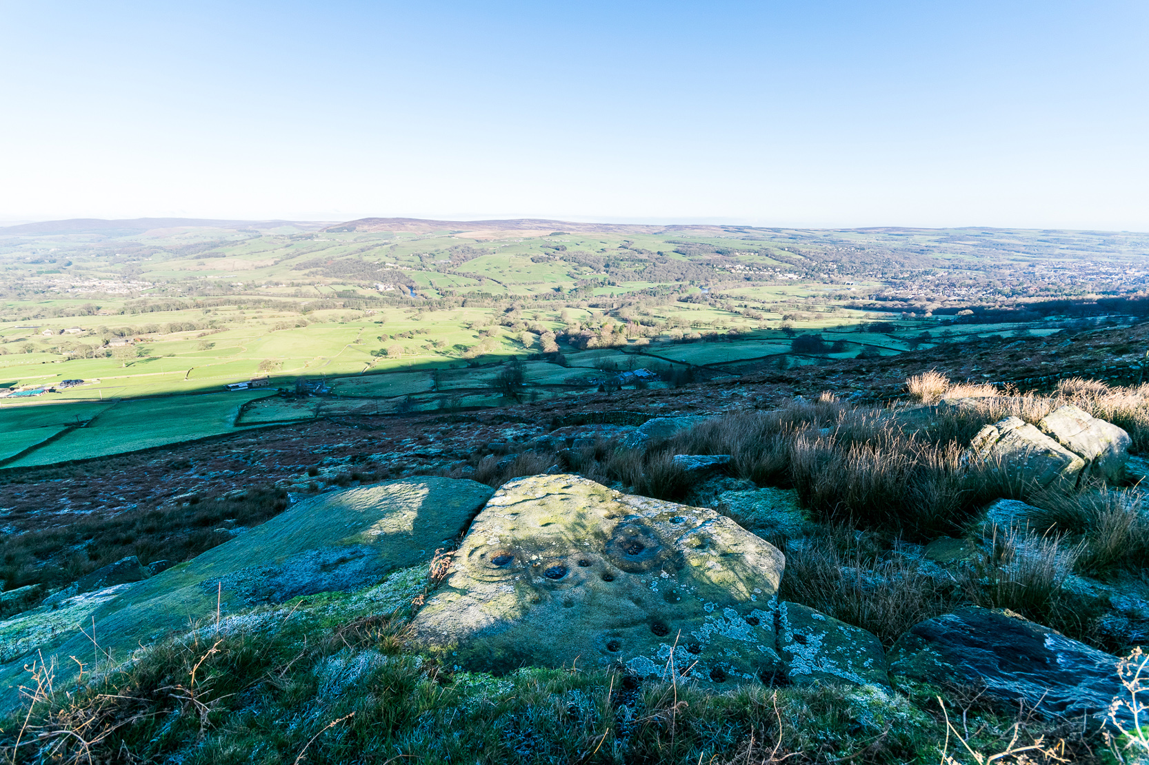
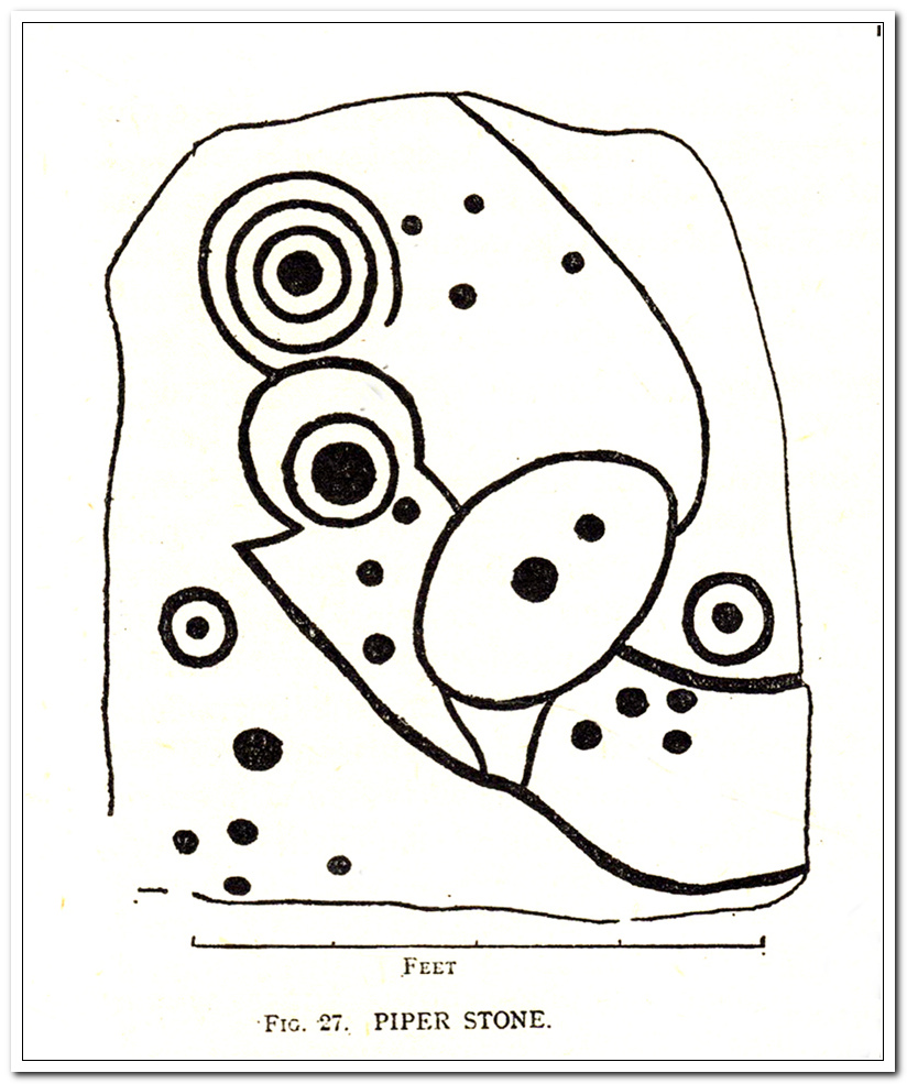
Follow the directions to reach our superb Swastika Stone from Ilkley, visible due to the iron railing that surround and protect the carving on the cliff edge. From here, keep walking west along the Millenium Way footpath, over the stile of the first wall, then the second wall—six in all—for ⅔-mile (1km), where you’ll see another small crag of rocks on your right, just yards from the footpath. You’re damn close!
Archaeology & History
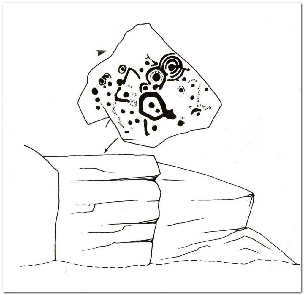
When the great J. Romilly Allen (1882) visited the Ilkley petroglyphs in 1878, the Piper Stone was one that he wandered over to see—and he had this to say of it:
“At the edge of Piper’s Crag is a horizontal rock-surface, and on a portion of it, measuring 5ft by 7ft, are carved a series of fifteen cups varying in diameter from 2 to 3 ins. Of these, one is surrounded by a single ring, four by a double ring, and one by a triple ring.”
Hedges 1986 sketchCowling’s 1940 sketch
This type of description, whilst accurate on the whole, rarely does justice to the carving. It was echoed more than 100 years later in John Hedges’ (1986) survey, when he described the large rock jutting out to possess merely, “a complicated design of cups, rings and grooves.” When Boughey & Vickerman (2003) did their follow-up survey, they added nothing more.
In an attempt to give some sort of meaning to the carving (and many others), the late great Eric Cowling (1940; 1946) placed it within Henri Breuil’s (1934) classification system, which assigns all carvings different degrees of complexity and form, from Classes 1-4. The Piper Stone entered Breuil’s Class 3A, being one “with deeply cut and smoothed down grooves.” Whilst this may sound good on the surface, in truth such classifications are utterly meaningless outside of the tables and graphs of statisticians and the boring. They give the appearance of quantitative research, but they have as much bearing on the nature of the carvings as an energy dowser healing the place with crystals.
In the flesh, in the real world—so to speak—from the Piper Stone we are looking, not just at the carving, but its place in the landscape: an ingredient that more and more emerging archaeologists are recognizing has a synergistic relationship with some petroglyphs. And here we have an impressive landscape that reaches out ahead of us for many miles. We look primarily to the north: the Land of the Dead in many traditional northern cultures. But our panorama here is 180º, with east and west horizons having the potential for measuring equinoctial periods in the cycle of the year. But in truth this is sheer speculation.
It’s a worthwhile carving to see, both for its views and its excess of non-linearity. In its form, Rorscharch impressions of early humans emerge; the usual solar and lunar symbols can be seen; star systems seem apparent; maps or settlement ground-plans could be there. We know that somewhere within it is the animistic ‘spirit’ of the rock itself, but the forms it exalts are, once again, all but lost on us modern folk…
References:
Allen, J. Romilly, “Notice of Sculptured Rocks near Ilkley,” in Journal of the British Archaeological Association, volume 38, 1882.
Allen, J. Romilly, “Cup and Ring Sculptures on Ilkley Moor,” in The Reliquary and Illustrated Archaeologist, volume 2, 1896.
Anonymous, Walks around Cup and Ring Stones, TIC: Ilkley n.d. (c.1990).
Baildon, W. Paley, “Cup and Ring Carvings: Some Remarks on their Classification and a New Suggestion as to their Origin and Meaning,” in Archaeologia, volume 61, 1909.
Bennett, Paul, “Cup-and-Ring Art”, in Towards 2012, volume 4, 1998.
Bennett, Paul, The Old Stones of Elmet, Capall Bann: Milverton 2001.
Boughey, Keith & Vickerman, E.A., Prehistoric Rock Art of the West Riding, WYAS: Wakefield 2003.
Breuil, Henri, “Presidential Address for 1934,” in Proceedings Prehistoric Society East Anglia, 7:3, 1934.
Collyer, Robert & Turner, J.H., Ilkley: Ancient and Modern, William Walker: Otley 1885.