Cup-Marked Stone (removed): OS Grid Reference – NZ 1480 6417
Archaeology & History
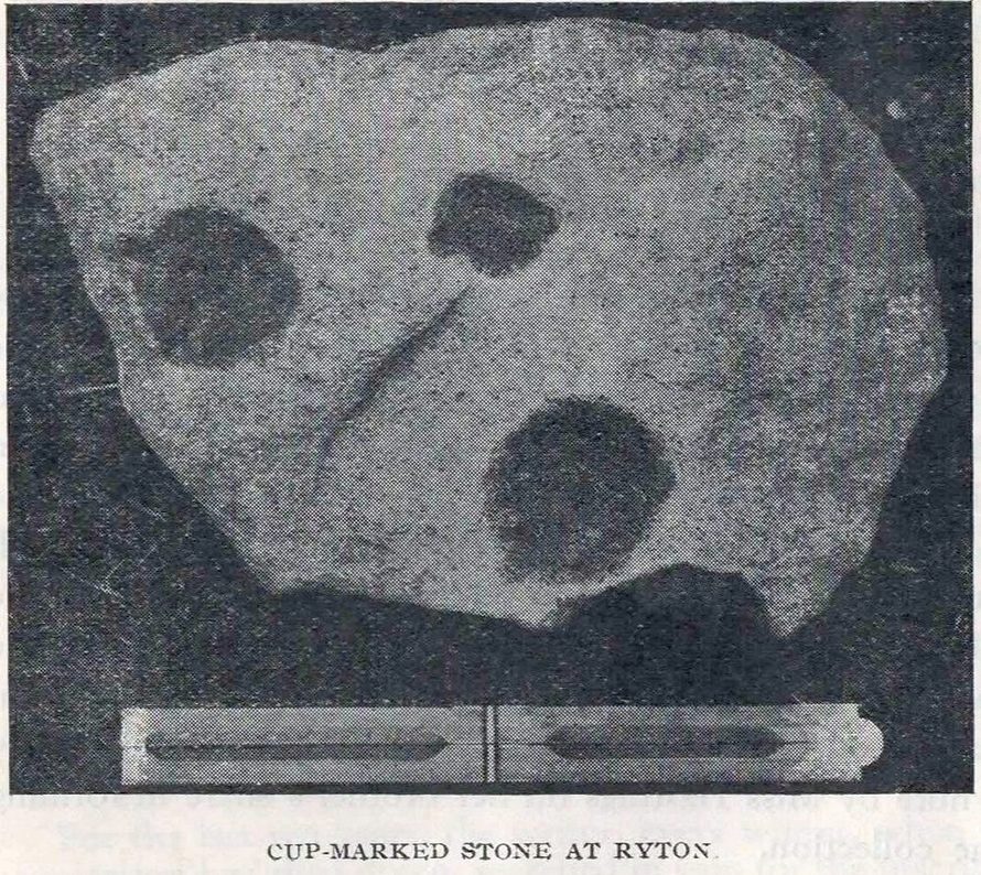
Ryton cup-marked stone
In a short piece read before Newcastle’s Society of Antiquaries in 1942, a Mr Cocks (don’t laugh!) told that when a friend of his was clearing out an old land drain in his garden, he found this fragmented cup-marked stone, “which had been made use of as a corner slab on the drain”! It was located “about 40 yards south-west of Tweedy’s Buildings,” on the west side of town. Broken from a larger piece of stone, the attached photo here shows the simple design of the basic cup-marks, measuring respectively 2½, 2 and 1⅝ inches across. Mr Cocks told that “there are also two finger-tip hollows on the stone tone which or may not be natural. A dark line running between the cups is a natural fissure.”
Last we heard, the stone was living in a box somewhere in the archives at the Great North Museum, Newcastle.
References:
Cocks, W.A., “A Cup-Marked Stone at Ryton,” in Proceedings Society of Antiquaries Newcastle-upon-Tyne, volume X, no.2, January 1943.
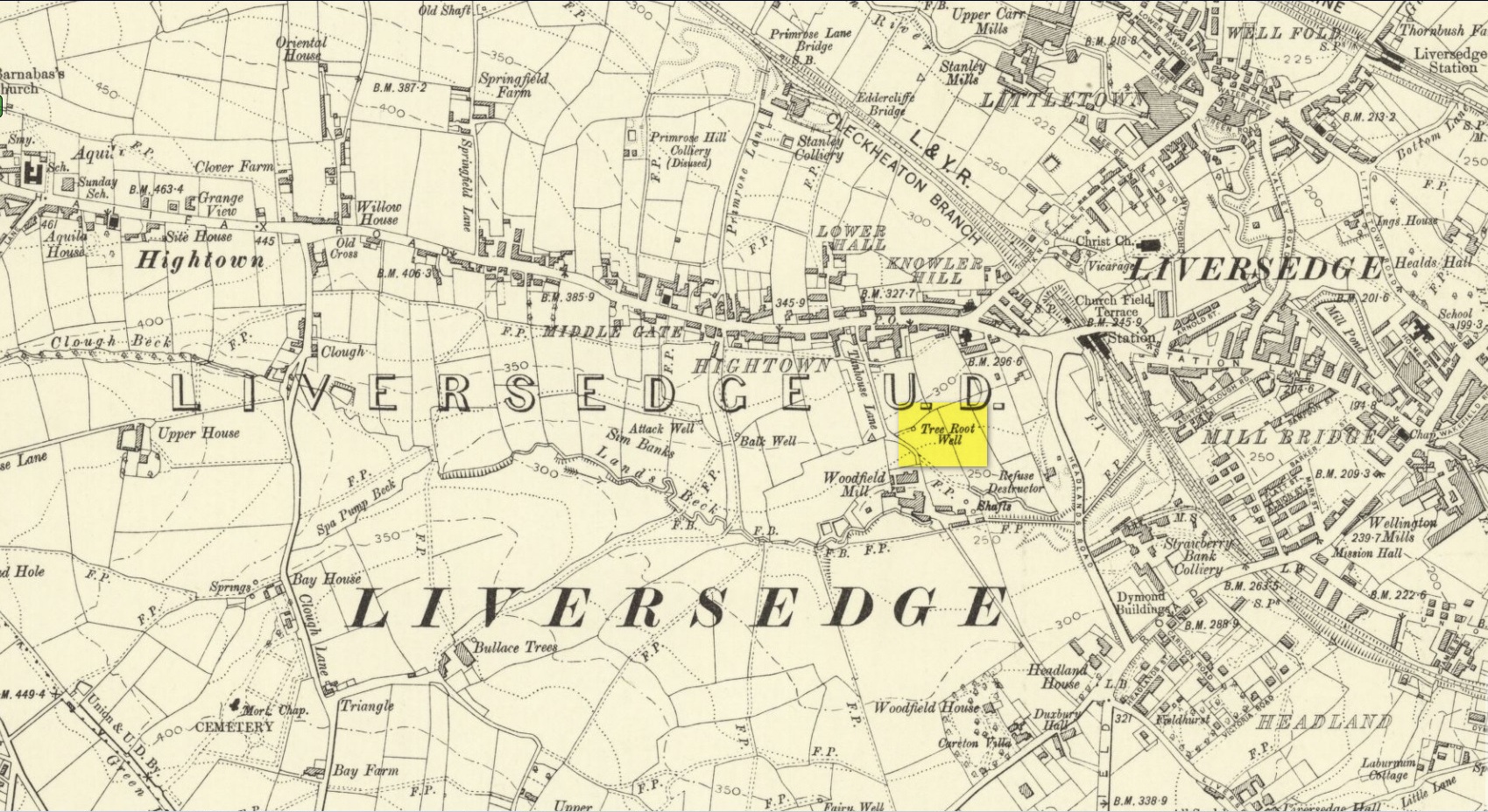
Along with the nearby Attack Well and Balk Well, this was one of three water supplies for the people of Middle Gate between Hightown and Liversdge in the 19th century. Found near the bottom of the old track known as Tanhouse Lane, its waters emerged at the base of some Victorian walling that’s built into the hillside, above which are the decayed remains of what seems to be an old hawthorn tree, whose roots obviously reached down to the stone trough, giving the place its name. Its waters have long since dried up and fallen back to Earth. Although it is shown on the 1908 OS-map of the region, I can find no virtues ascribed to the well nor any local history notes.
Acknowledgements: Huge thanks to the great Gary Ferner, for help in locating the site and the day’s venture!
Holy Well (lost): OS Grid Reference – NC 725 538 (approximation)
Archaeology & History
It would appear that there’s only one literary reference to this seemingly lost holy well, located halfway down megalithic Strathnaver, somewhere close to the legendary Loch ma Naire. James Horsburgh’s (1870) essay on the antiquities of this area mentioned it, almost in passing, in his description of the Dun Viden broch. He told that,
“Close to Dun Viden is Loch Manaar, where dozens of people come twice every year for the cure of diseases. They come before sunrise, bathe in the loch, walk round it, drink from a holy well (my emphasis), and throw some pieces of money into the loch. There is a legend about this loch, which I forget; but a woman was chased by a priest, and threw something in it, and called out that it was Loch Manaar—that is, the loch of my shame. “
The holy well is referred to in Historic Scotland’s Canmore entry, citing both the New Statistical Account and Name Books as referrals to the site, yet neither of them include this well in their surveys; it is only through Horbugh that we hear of this site—and we know not where it lived! In the event that it still exists, we’d expect it to be not more than 2-300 yards from the edge of Loch ma Naire; or perhaps it may be the source of the Loch ma Naire burn itself, nearly a mile to the east…. Seek and thee shalt find, as the old saying goes…
Roughly halfway between Bettyhill and Tongue on the A836 road, keep your eyes peeled for the sign to Skerray (4 miles) and travel down that road. About 1¾ mile on, take the tiny lane on your left up the slope for 0.6 miles (1km), and just before the sharp bend in the road (across a small bridge) there’s a gate on your left. Go thru here and follow the tiny path alongside the burn (stream) westwards for half-a-mile until where the waters become a bog within a wide oval bowl in the landscape. At the far-side you’ll see two large boulders sat above this watery bowl. That’s where you need to be!
Archaeology & History
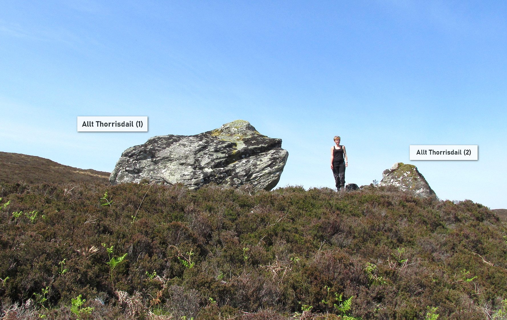
The big fella of the two
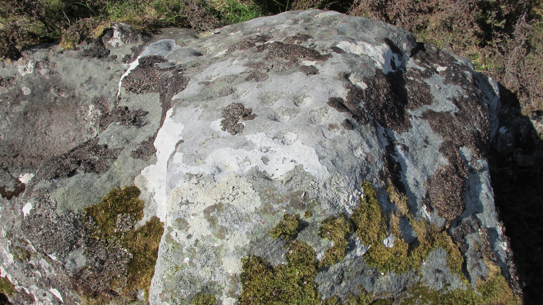
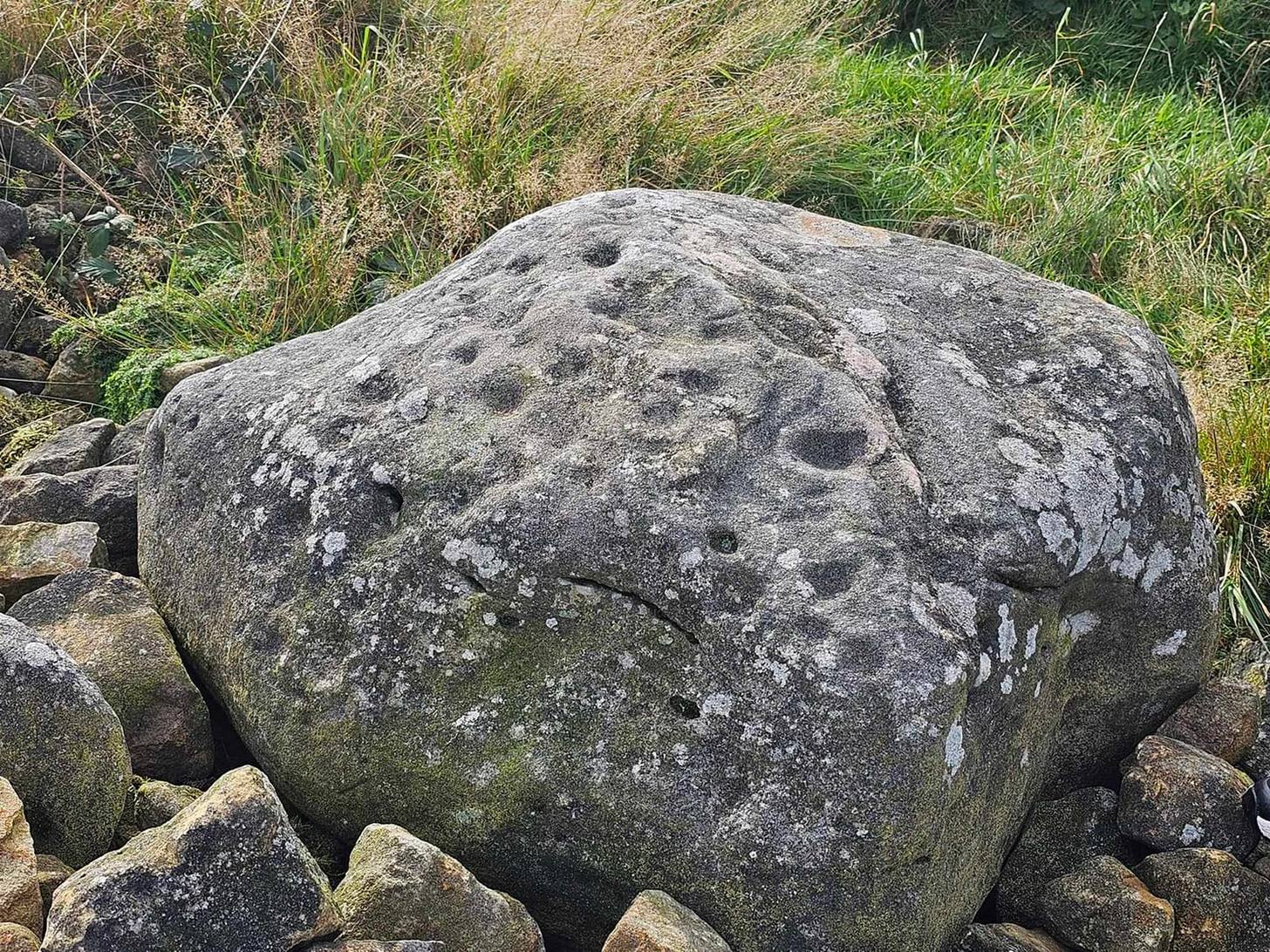
This is carving “number one” of two great incised boulders that are sat upon a natural ridge overlooking a dried-up lochan. An impressive spot that give a thoroughly distinct impression of altar stones above the sunken waters, from whence rites and proclamations were performed. It has that look and feel about it—and any animist would tell you the same. My hardcore dreams aside though…
This profile is for the larger of the two boulders that live here (Allt Thorrisdail 2 is here). It has very curious petroglyphic attributes—much like its compatriot—unlike many of those in these northern lands. The pair of them seem to have been described for the first time in Hew Morrison’s (1883) fine meanderings through the mythic history of the region. He told that,
“About a mile distant (from Torrisdale) two large cup marked boulders lie on the slope of a hill. The marks are disposed in groups of one large and nine smaller cups. On the larger boulder there are two of these groups and seven separate marks.”
There are slightly more than that, and this was pointed out when the Royal Commission (1911) lads came to see it:
“The largest boulder, that situated furthest west, is about 8 feet high and 14 feet in length. On its south side, chiefly on the flat and less abrupt face of the stone, are groups of cup-marks of from 2in to 3in in diameter, the deepest being about 1in in depth, while a number are now almost obliterated. The extent of the markings is not very definite, but there appear to be two groups containing about twelve cup-marks each.”
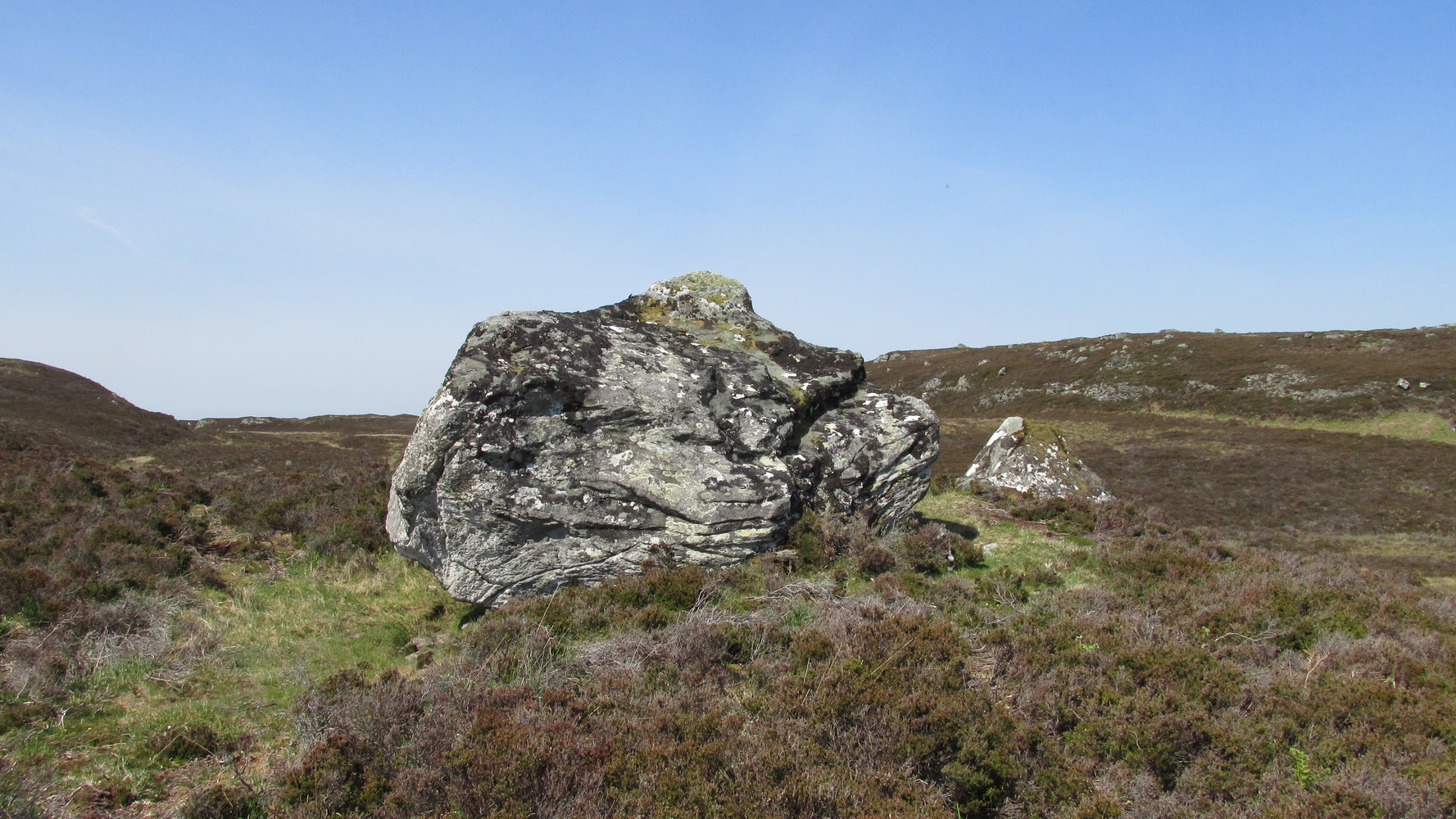
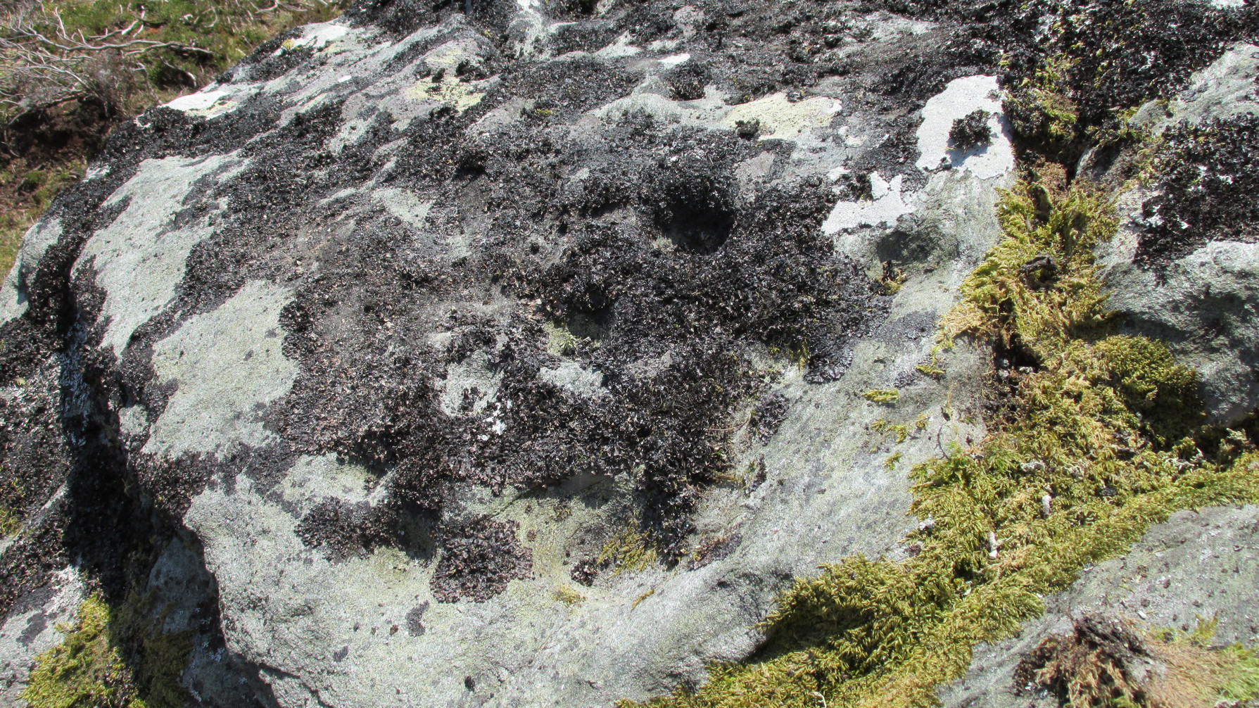
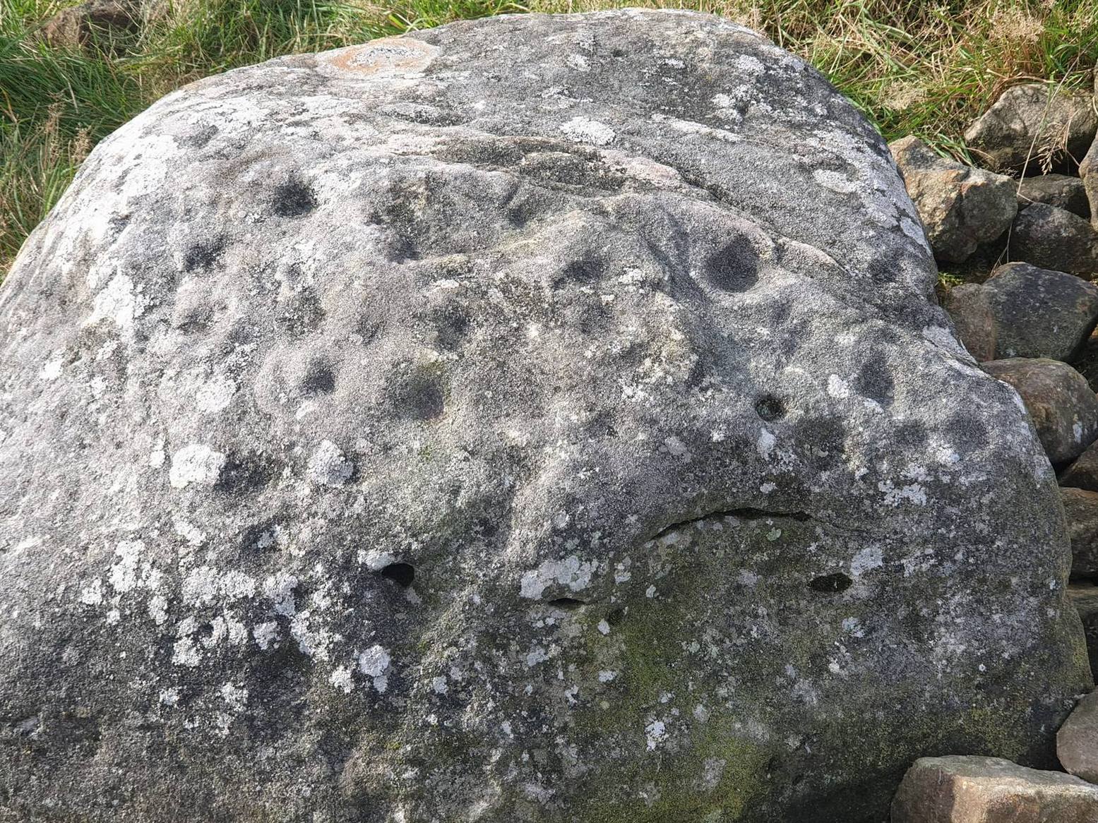
Another chorus of cupsLichen-dappled cupmarks
But this only tells of half the stone’s symbolic story. For on the vertical northern face of the rock, from just above ground-level, we have a distinct almost straight line of many cup-marks, going up diagonally, at an angle of about 35º. I took a number of photos of this aspect of the stone, but the covering of lichens didn’t highlight them clearly at all. When you’re stood looking at them they stand out like a sore thumb!
I have to be honest and say that I bloody well love this site! You have to paint the entire environment in the right light, as it was when the stone was first carved, surrounded by the scattered woodland of birch, pines and rowan all across where now we have stunning barren moorlands. Tis a ritual place indeed – without any shadow of doubt!
References:
Mercer, R.J., Archaeological Field Survey in Northern Scotland 1976-1979, University of Edinburgh 1980.
Royal Commission on Ancient & Historical Monuments, Scotland, Second Report and Inventory of Monuments and Constructions in the County of Sutherland. HMSO: Edinburgh 1911.
Acknowledgements: Huge thanks to Sarah MacLean for her company and landscape knowledge in visiting this and other nearby antiquarian remains. And to Aisha Domleo, for getting me into this neck o’ the woods.
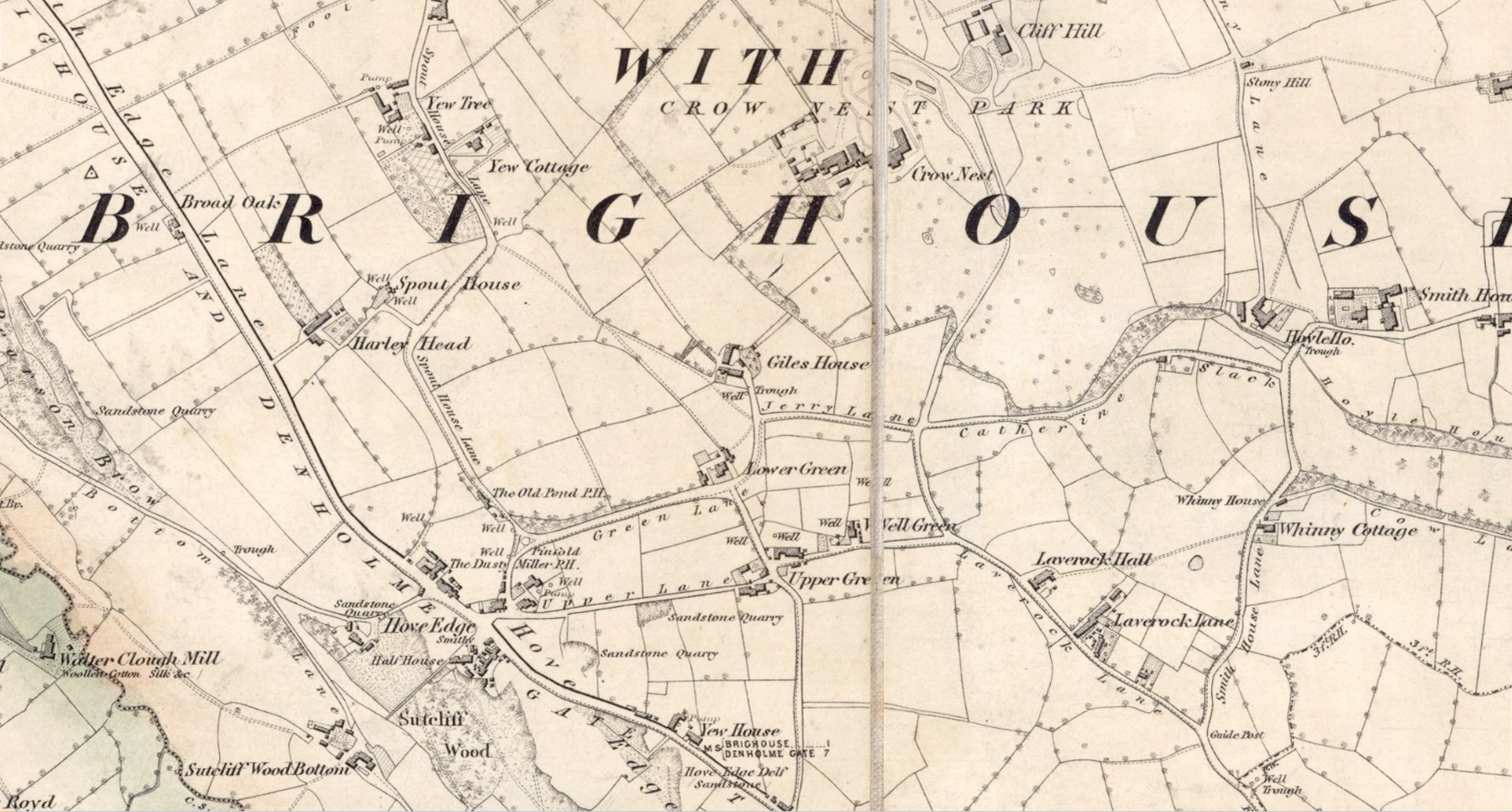
In times gone by there was a singular St.Giles’ Well in the old village of Lightcliffe, but the only reference we have of it is from one of James Parker’s works (1904) where, in his description of St. Giles’ House, he tells, “It derives its name from an ancient well, called ‘St. Giles’ Well,’ which once existed near to the house, and was dedicated to St. Giles”: an 8th century Greek prince who left everything to become a hermit. He lived on wild herbs and developed the ability to cure rheumatism (perhaps a curative aspect of the well), cripples and help beggars. He is the patron saint of woodlands and his symbol is the arrow gained after he healed a wounded doe shot by one (the mass of Robin Hood folklore in this area may have something to do with this symbolism). His date is September 1.
A.H. Smith (1963) cites the “local tradition that it is named from a well dedicated to St. Giles,” but thinks this attribution to be an unlikely one. As can be seen on the accompanying map, a great number of wells are in this area, none of them named, with one just below the said Giles House.
References:
Parker, James, Illustrated History from Hipperholme to Tong, Percy Lund: Bradford 1904.
Smith, A.H., The Place-Names of the West Riding of Yorkshire – volume 3, Cambridge University Press 1961.
Acknowledgements:Huge thanks for use of the Ordnance Survey map in this site profile, reproduced with the kind permission of the National Library of Scotland.
From Holymoorside, take the long straight Loads Road running west out of the town into Longside Road. ¾-mile along, past Home View and just before Well Lane (on the right), there’s a public footpath sign pointing into the fields on your left. Walk dead straight, dead south along the wallside for 450 yards, then walk straight left again along the other wall until you reach the tiny bit of moorland less than 150 yards away. The carved rock is just on the other side of the stile at the edge of the old walling. You’ll find it.
Archaeology & History
Rediscovered sometime in 2002, this would seem to be an isolated cup-and-ring stone. It was first mentioned in John Barnatt’s (2003) short gazetteer of Peakland petroglyphs, where he wrote,
“This irregularly-shaped small boulder was identified recently lying amongst post-medieval field clearance adjacent to a field corner and footpath… Its upper parts ar covered with 40-46 cupmarks. On the exposed irregular top they are badly worn and sometimes uncertainly identified. In one instance a cup is partly encircled by a worn ring, while a second partial ring nearby may be fortuituous. On a ledge near one edge of the boulder preservation is better and the cups are clearly defined and densely arranged.”
The stone looks as if it’s been moved into its present location, obviously for use in the walling. It’s original position would have been somewhere close by, but we know not where that might be.
References:
Barnatt, John & Robinson, F., “Prehistoric Rock Art in Ashover School and Further New Discoveries Elsewhere in the Peak District,” in Derbyshire Archaeological Journal, 123, 2003.
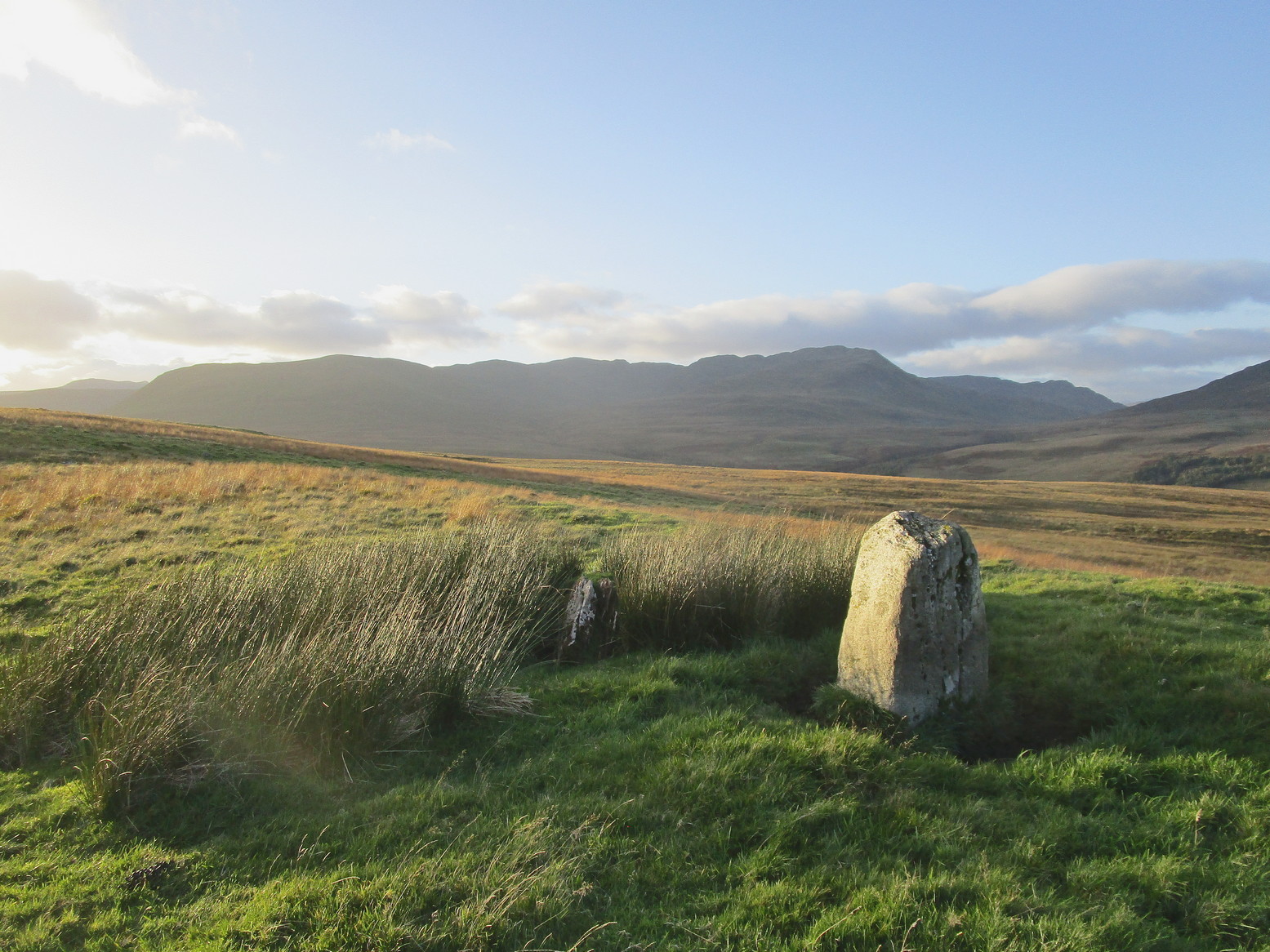
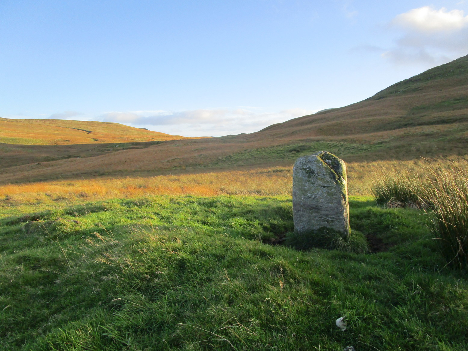
Make a day out of this one, visiting several old places on the way. From Comrie take the B827 road to Braco, turning right at the tiny Glen Artney road a half-mile along (easy to miss). 3 miles along, pass the derelict Dalness cottage, you can follow the directions to get to the Mailer Fuar (2) cup-and-ring stone; and from here go up the field past the Mailer Fuar (1) carving, through the gate and follow the fence to your right. Keep going till your reach the Allt na Drochaide cup-and-ring stone. From here you’re heading (south) towards the rounded crags of Cnoc Brannan. It’s boggy as fuck in parts so cautiously zigzag through this section up towards the small grassy rise about 350 yards from the cup-and-ring stone. You’ll find it!
Archaeology & History
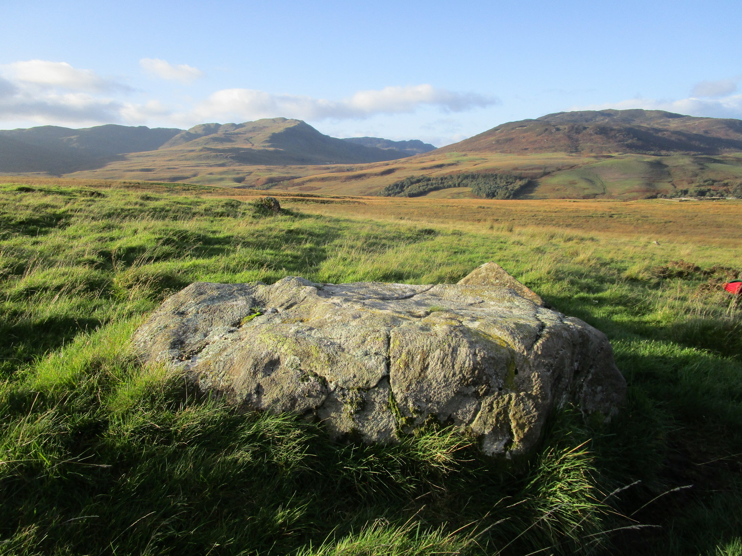
From the old stone, gazing S
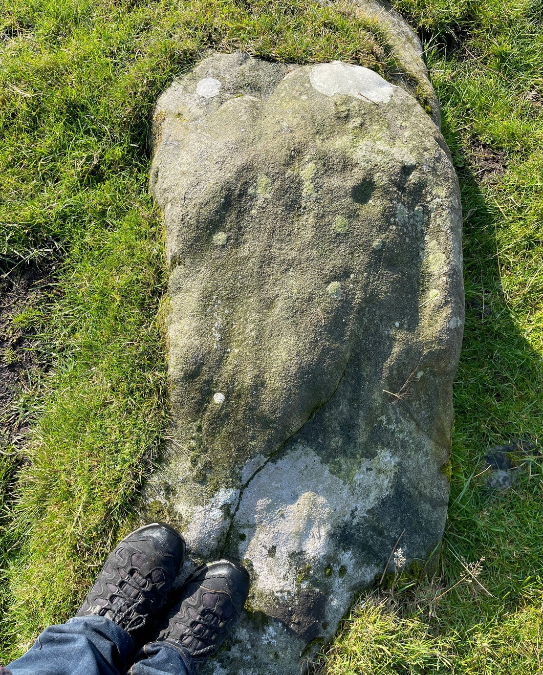
On one of the gentle rises below the northern slope of Cnoc Brannan we find this sturdy old fella, 3-4 feet tall (I didn’t measure it), looking across the stunning landscapes north, east and west along Glen Artney. Not previously recorded and seemingly isolated from other prehistoric remains, he looks all alone at first sight, but laid down in the grassy rushes (Juncus conglomeratus) to his side, is a slender seven-foot long stone which may have stood upright in the not-too-distant past, giving us another double stone setting in this area (at least two others existed in this area—the closest being at Craggish, 3.7 miles northeast). I have little doubt that other undiscovered prehistoric remains are hiding in the area. (there are a number of single cup-marked stones in the locale, although I tend to leave such examples off the catalogues as they can be somewhat dubious [and many are]. I mention this just in case any rock art students want to forage the area.)
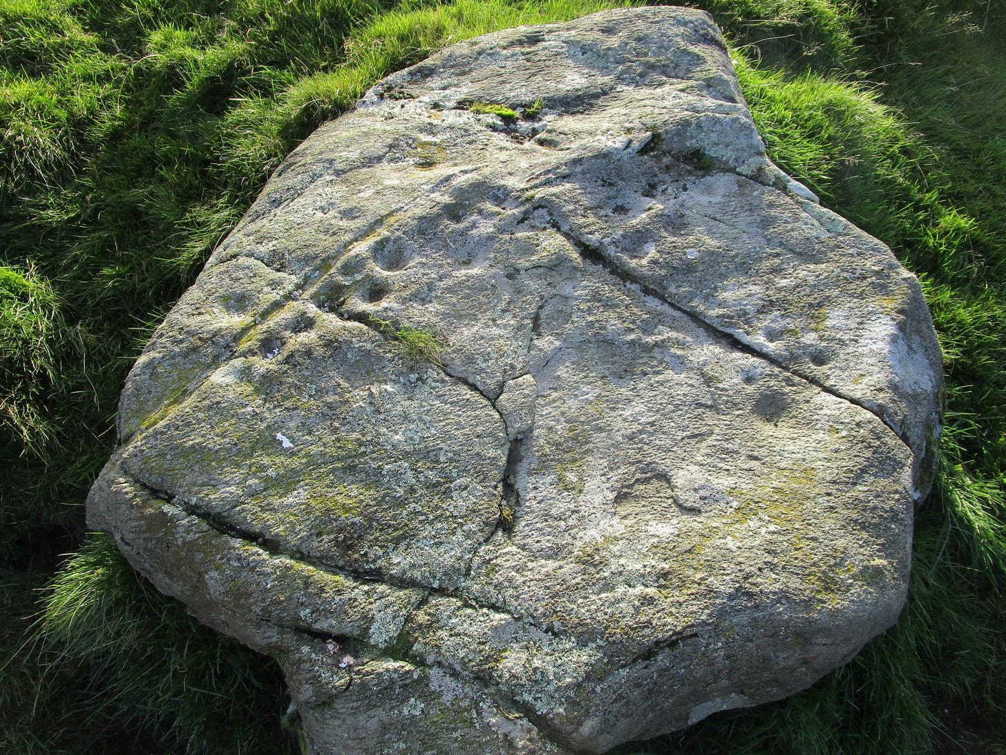
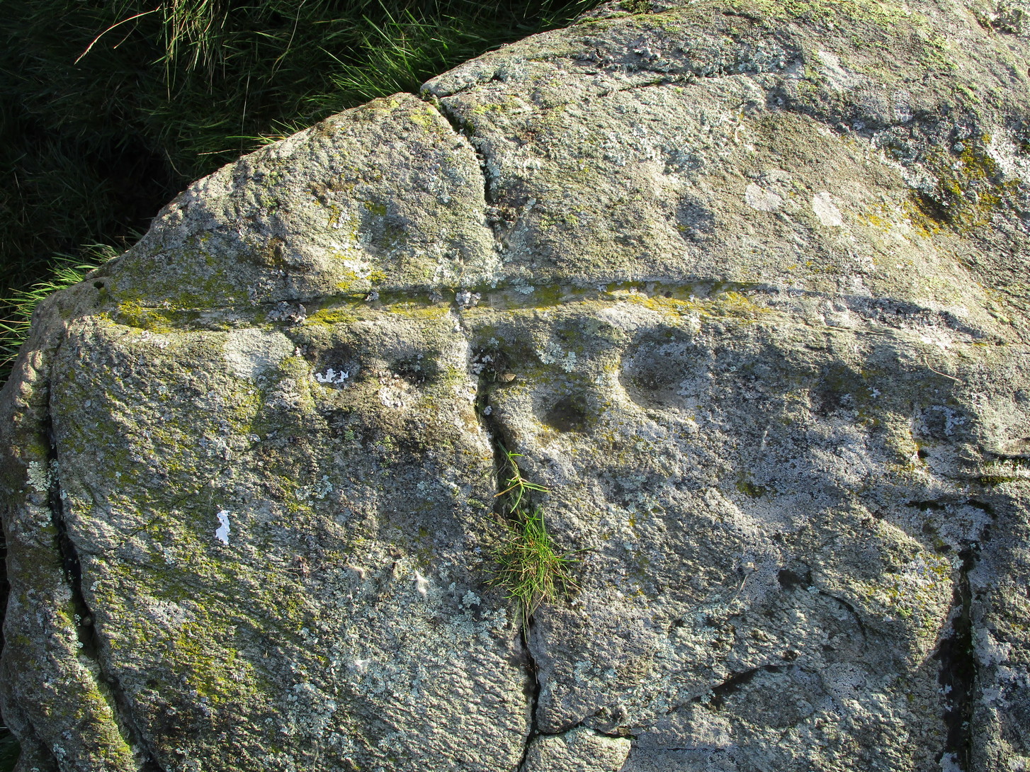
Numerous ways to get here, it’s probably the easiest (direction wise) to reach here starting from Dick Hudson’s public house on the southern road surrounding Rombalds Moor. From the pub, head left (east) along Otley Road (passing Weecher reservoir) for 1.9 miles (3.1km) until you reach Reva reservoir where a track leads you to the waters. A small parking spot is on the left-side of the road. From here, go through the gate and up the footpath (north) for about 200 yards then turn right and go up the field towards the wall where, about 20 yards before it, you’ll see find the stone in question.
Archaeology & History
This long earthfast stone has two distinct cup-markings: one near its northern upper end, and the other near the lower southern end, as highlighted on the above photo. (forgive the poor image, but we took it when the sun was pretty high in the sky) It seems as if there are two or three other very faint cup-marks on the upper end of the stone, close to the most distinct one, but none of our photos show them with any clarity.
Acknowledgements: Huge thanks to Sarah Walker and Thomas Cleland for help with location and imagery for this stone.
From Comrie take the B827 road to Braco, passing the large Roman Stone monolith, turning right at the tiny Glen Artney road a half-mile along (easy to miss). 3 miles on, pass the derelict Dalness cottage, you can follow the directions to get to the Mailer Fuar (2) cup-and-ring stone; and from here go up the field past the Mailer Fuar (1) carving, through the gate and follow the fence to your right, then drop down into the great boggy reeds, over the burn and up as if you’re heading to the rounded hill of Cnoc Brannan. On a grassy knoll a hundred yards or so up the slope, you’ll see a rock or two. It’s thereby!
Archaeology & History
The stone in its setting
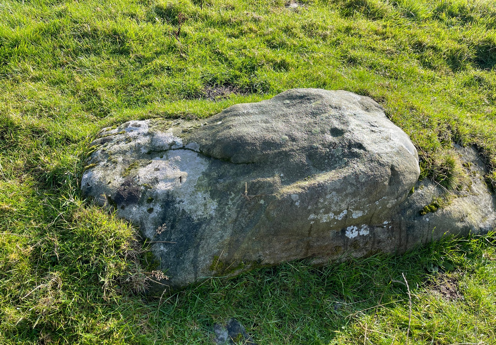
I came across this petroglyph not too long ago on the same day I found the Cnoc Brannan standing stone a little further up the slope from here. Covered in cup-markings over all except the northeastern portion of its surface, a faint ring seems to be around one of them on its northern side. Of the twenty-two cups on the stone, the majority of them, as the photos show, are clustered alongside a curved natural scar that runs across the topmost section of the rock. There are less pronounced faded cups on the more northern and western portions of the rock, with what looks like one on its near-vertical southern face. Despite its lack of complexity, it has an impressive feel to it.
Main cluster of cups
The home of this carving in its natural setting is what stands out when you’re up here and is certainly what gives it that vibe! The wooded greenery of Glen Artney stretches ahead of you to the east and west, with the craggish mountains of Beinn Dearg, Halton and their compatriots drawing you to the northern side. Tis a gorgeous arena indeed! So, if you’re going to visit its near neighbors at Mailer Fuar a half-mile below, stick this one on your itinerary and, if you’re the roving type, get your feet wet and look around for some more of them. There’ll be others, as yet unknown, hiding away nearby…
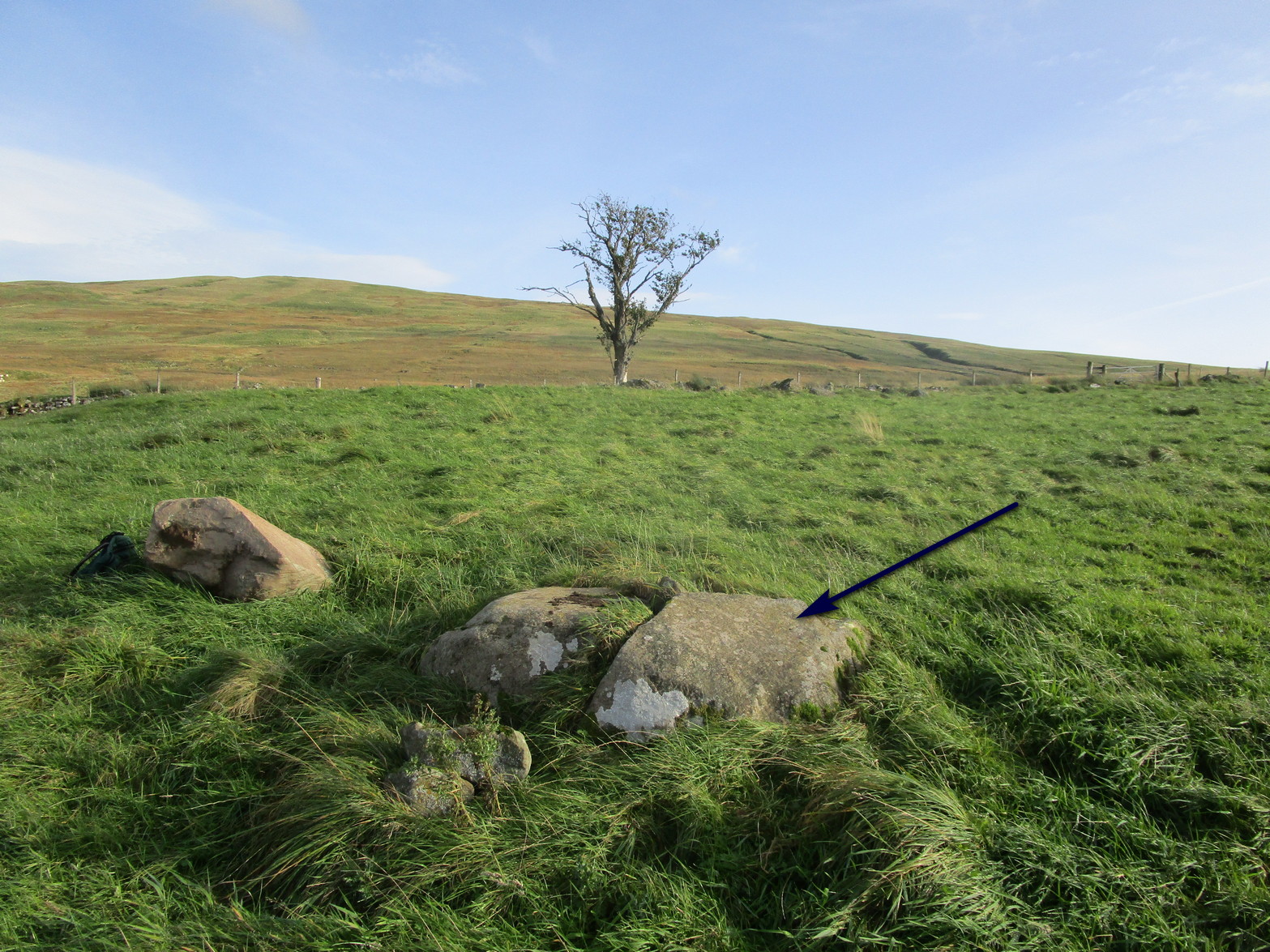
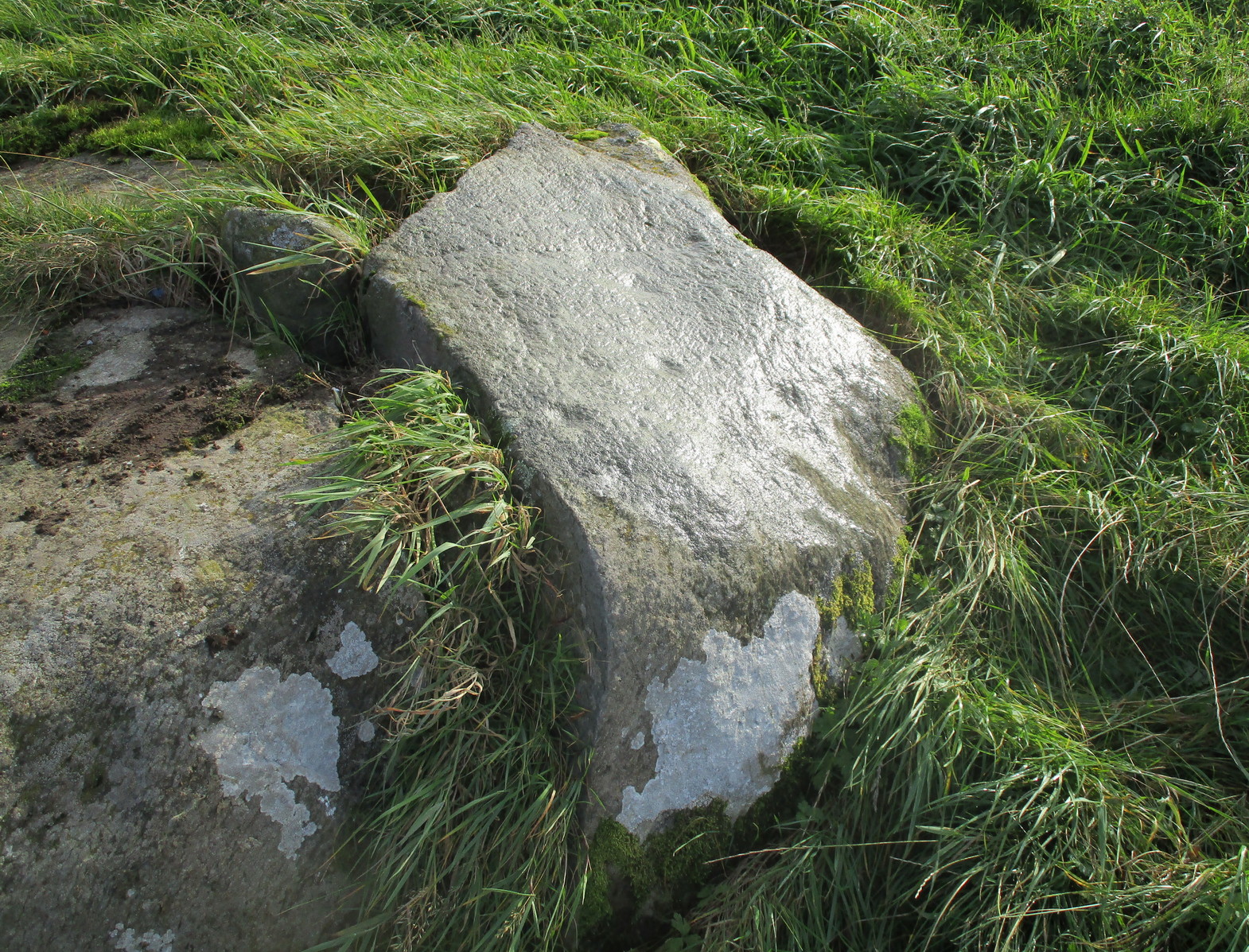
From Comrie take the B827 road to Braco and less than a mile out of town take the tiny Glen Artney road on your right. Past the derelict Dalness cottage 3 miles on, a half-mile further, there’s a gated road veering downhill on your right. Park in the small parking-spot at the left. Walk along 100 yards to the gate on your left and walk up the old path which bends back on itself before leveling out. As it does so, just where the Mailer Fuar (2) carving lives, head uphill to the derelict house and, before reaching the fence, check out the several isolated stones on your right. You’ll find it!
Archaeology & History
Several faint cupmarks
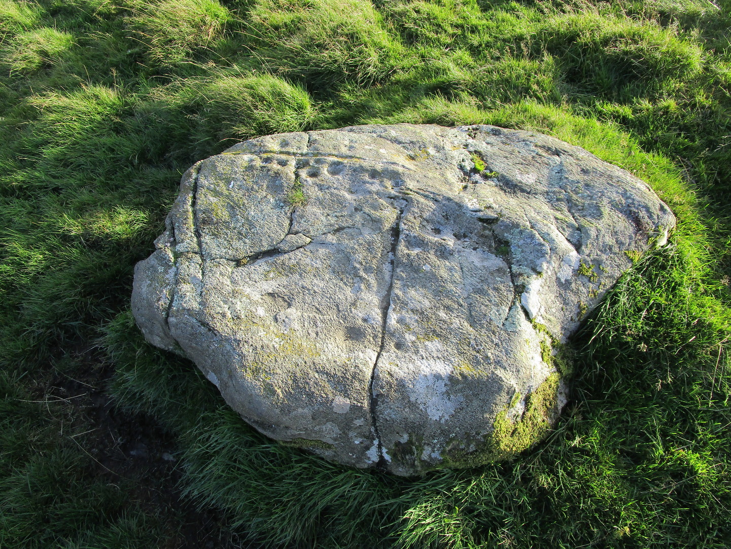
This is nowt special to look at and, as I always tend to say with carvings such as this, it’s probably only gonna be of interest to the petroglyphic puritans amongst you. It was described by George Currie (2006) as possessing just one cup-mark, but there are in fact at least three of them on this sloping rock face, possibly four. One of them may—may—have a half-ring around it, but this is very hard to see and might be little more than a trick of the light and just a forlorn hope of something better… It’s worth a brief look before you venture further uphill to the much more impressive Allt na Drochaide carving.