Panorama Woods (228), Ilkley, West Yorkshire

Cup-and-Ring Stone:  OS Grid Reference – SE 11468 47288

Also Known as:

  1. Carving no.100 (Hedges)
  2. Carving no.228 (Boughey & Vickerman)

Getting Here

Panorama Stone 228, with cups highlighted (after James Elkington)

Come out of Ilkley/bus train station and turn right for less than 50 yards, turning left up towards White Wells.  Go up here for less than 100 yards, taking your first right and walk 300 yards up Queens Road until you reach the St. Margaret’s church on the left-hand side.  On the other side of the road, as well as a bench to sit on, surrounded by trees is a small enclosed bit with spiky railings with Panorama Stones 227, 228 and 229 all therein: the one in the centre being the one we’re dealing with here.

Archaeology & History

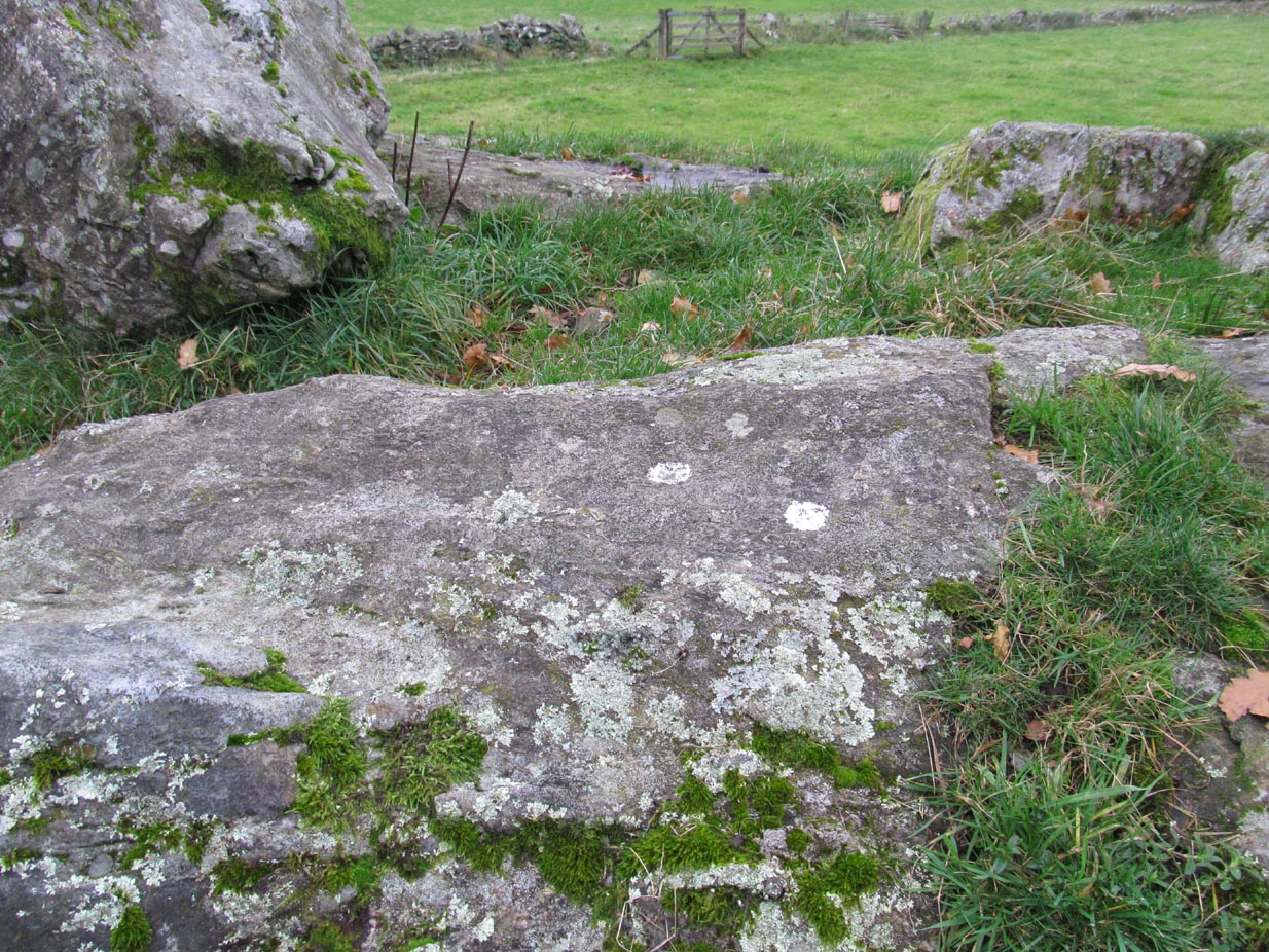
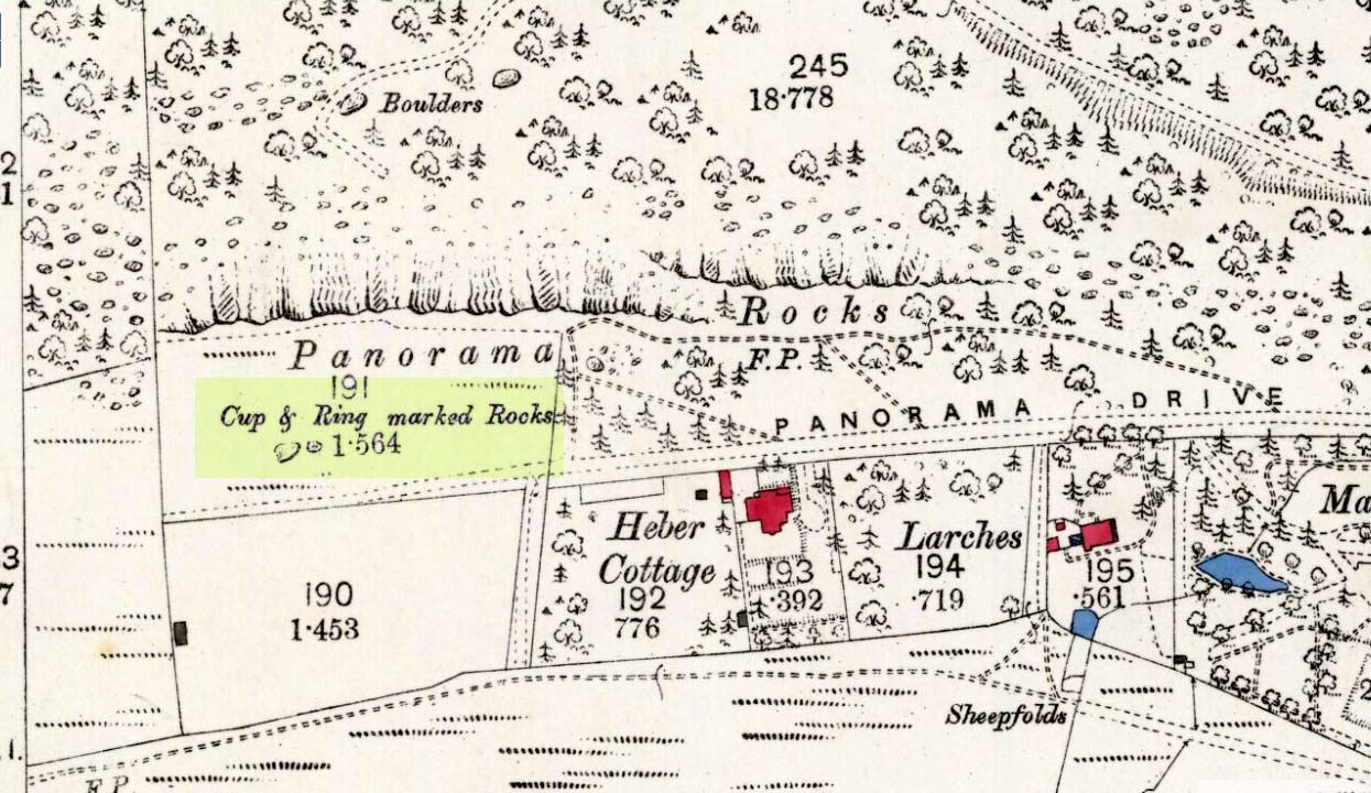
Originally located ¾-miles (1.2km) WSW of its present position in Panorama Woods (at roughly SE 10272 46995), along with its petroglyphic compatriots in this cage, the carving was moved here in 1890 when a Dr. Little—medical officer at Ben Rhydding Hydro—bought the stones for £10 from the owner of the land at Panorama Rocks, as the area in which the stones lived was due to be vandalized and destroyed. Thankfully the said Dr Little was thoughtful and as a result of his payment he had some of the stones saved and moved into their present position.  However, this carving is but a fragment of its former self.

John Hedges 1986 sketch
Close-up of cups (James Elkington)

It was originally to be seen within a large prehistoric enclosure—which was completely destroyed when rich houses were built hereby, without any evaluation of the site ever being made.  But particularly impressive is the fact that this now enclosed sedated stone carving was originally the large rocky base for a small rocking stone, which also had cup-markings on it and a faint cup-and-ring.  This is very unusual indeed – and perhaps unique in Britain?  Thankfully, several Victorian antiquarians visited and made notes and a sketch of the site before it was uprooted and a large section of it destroyed.  In J. Romilly Allen’s article (1879) he told that, just a couple of yards from the more famous and ornate Panorama Stone (229), a

“second stone is of irregular shape, measuring 15ft by 12ft, and supporting a smaller stone of triangular shape 6ft long by 4ft broad.  Both upper and under stone are covered with cups and rings, but the sculptures have suffered much from exposure.  The superimposed rock has eleven cups, two of which are surrounded by rings.  The under stone has 42 cups, nine of which have rings.  Amongst these are two unusually fine examples, one has an oval cup 5in by 4in, surrounded by two rings, the diameter of the outer ring being 1ft 3in.  Another has a circular cup 3in diameter, and five concentric rings, the outer ring being 1ft 5in across.”

J.T Dales 1878 sketch, with CR227 on top of it
Original location of stone

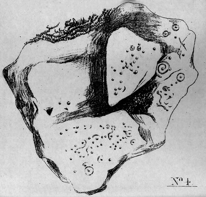
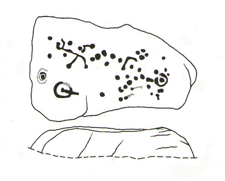
In a sketch of the site by J. Thornton Dale done about the same time as Allen’s visit, and reproduced here (apologies for the poor quality), the “five concentric rings” that Mr Allen mentioned are not shown, but clearly a spiral design had been seen by Mr Dale’s eyes.  Fascinating…. The large mass of carvings immediately left of the spiral is in fact the smaller upper stone known by modern archaeologists as carving 227.

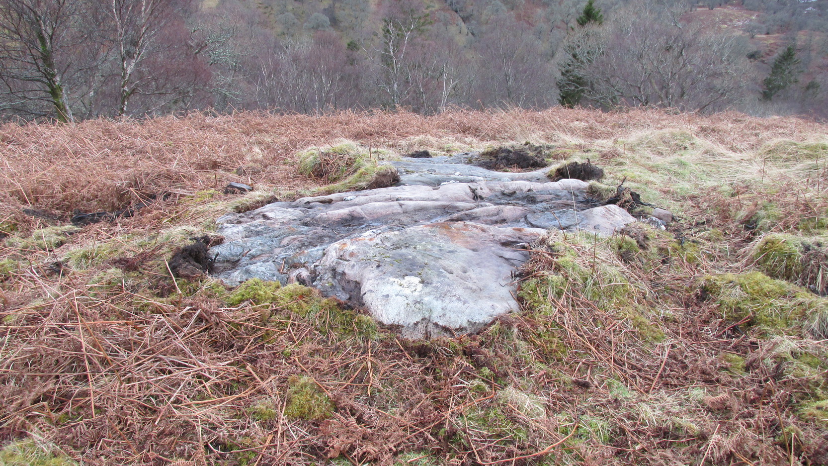
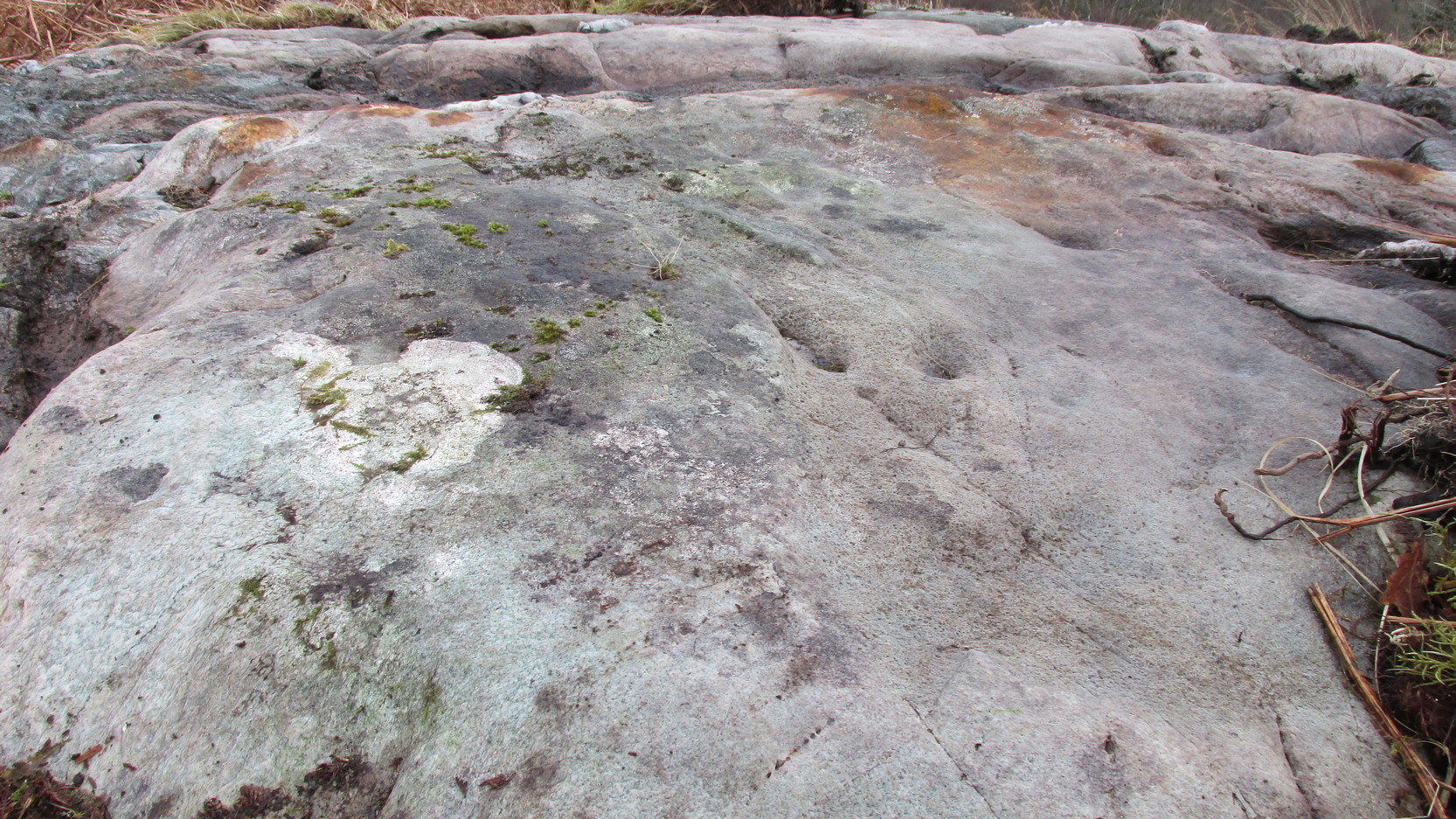
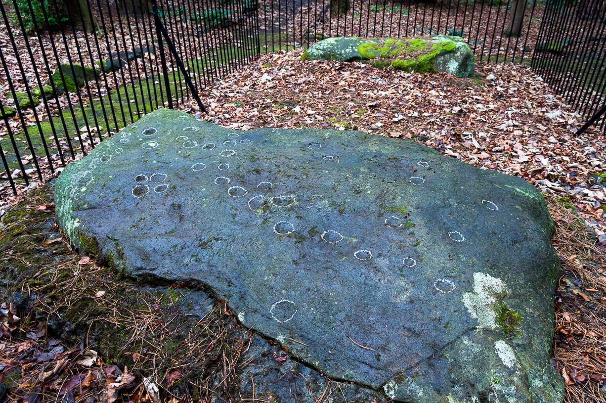
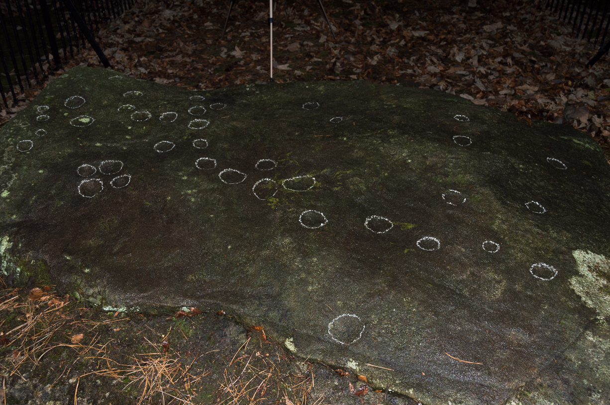
Today, all we can see of this petroglyph are two cup-and-rings, and one faint double-cup-and-ring; several incomplete rings or arcs, and at least another 30 single cup-marks, some of which have short limes running to or from them.  The rest of original stone base with its other multiple rings or spiral design were obviously destroyed.

As with many of the Ilkley carvings, Boughey & Vickerman’s (2003) description barely does the stone justice.  They described it simply:

“Large rock, now set in concrete base, the surface rapidly deteriorating.  Over forty cups, three with single rings, one showing traces of a second, grooves.”

The mightily impressive Panorama 229 carving sits next to this one and is truly worth checking out!

References:

  1. Allen, J. Romilly, “The Prehistoric Rock Sculptures of Ilkley,” in Journal of British Archaeological Association, volume 35, 1879.
  2. Bennett, Paul, The Panorama Stones, Ilkley, TNA: Yorkshire 2012.
  3. Bennett, Paul, Aboriginal Rock Carvings of Ilkley and District, forthcoming.
  4. Boughey, Keith & Vickerman, E.A., Prehistoric Rock Art of the West Riding, WYAS: Leeds 2003.
  5. Cowling, Eric T., Rombald’s Way, William Walker: Otley 1946.
  6. Downer, A.C., “Yorkshire Archaeological and Topographical Association,” in Leeds Mercury, August 28, 1884.
  7. Hadingham, Evan, Ancient Carvings in Britain, Souvenir Press: London 1974.
  8. Hedges, John, The Carved Rocks on Rombald’s Moor, WYMCC: Wakefield 1986.
  9. Heywood, Nathan, “The Cup and Ring Stones of the Panorama Rocks”, in Transactions Lancashire & Cheshire Antiquarian Society, Manchester 1889.
  10. Speight, Harry, Upper Wharfedale, Elliott Stock: London 1900.

Acknowledgements With huge thanks to both Dr Stefan Maeder for help in cleaning up the stones; and to James Elkington for taking the photos and allowing ’em for use them in this site profile.

© Paul Bennett, The Northern Antiquarian


Abbey Craig, Stirling, Stirlingshire

Hillfort:  OS Grid Reference – NS 8094 9566

Also Known as:

  1. Canmore ID 47113
  2. Wallace Monument Fort

Getting Here

Abbey Craig on 1866 map

Most folk visiting here are coming from Stirling city.  There are various buses to get here, which head out over Stirling Bridge along Causewayhead Road (the A9) for half-a-mile where, at the roundabout and the William Wallace pub, go straight across up the minor road, zigzagging back on itself, until you reach the signs for the Wallace Monument.  Follow the well-defined footpath and, once on top of the hill, walk round the back of the mightily impressive tower.

Archaeology & History

Located right where the impressive Wallace Monument proudly stands, this prehistoric precursor to Sir William Wallace’s memory was where Scotland’s legendary hero and his men cast a clear and easy view over Bannockburn, where the halfwit english came for a fight—and deservedly lost!   The structures that used to be inside the now denuded hillfort would, no doubt, have been used by Wallace’s men; but much of those prehistoric remains have now been destroyed.  The visible remains of the fort can be seen round the back of the Wallace Monument: elongated rises of overgrown walling that run almost all the way round, getting slightly higher as you approach the more northern edges, like a semi-circular enclosure.

Royal Commission plan
Abbey Craig – and the great Wallace Monument

The site was described very briefly in William Nimmo’s (1880) early survey of the area, where he told that in 1784, “eleven brazen spears were found on the Abbey Craig, by a Mr Harley”, which he thought came from the time when the earlier ‘castle’ stood here.  He was probably right.  Many years later, the prehistoric remains were included in the county survey of archaeological sites by the Royal Commission lads (1963), who told that, near the north end of the summit of Abbey Craig,

“there is a fort which has been damaged by the construction within it of the Wallace Monument.  All that remains is a substantial turf-covered bank, cresentic on plan and 260ft in length, the ends of which lie close to the brink of the precipice that forms the west face of the hill.  The bank stands to a maximum height of 5ft above the level of the interior and presumably represents a ruined timber-laced wall, since numerous pieces of vitrified stone have been found on the slopes immediately below it.

The entrance to the fort presumably lay between one end of the bank and the lip of the precipice, but both the areas concerned have been disturbed by the construction of the modern approaches.  The interior of the fort measures about 175ft from north to south, by about 125ft transversely and the interior is featureless.”

The fort was probably built sometime in the early Iron Age; so the next time you visit this fine spot, check the remains out round the back of the tower—and remember that our ancestors were living up here 2500 years ago!

References:

  1. Aitchison, N.B., “Abbey Craig Rampart’, in Discovery & Excavation, Scotland, 1981.
  2. Feacham, Richard W., Guide to Prehistoric Scotland, Batsford: London 1977.
  3. Hogg, A.H.A., British Hill-Forts: An Index, BAR: Oxford 1979.
  4. Nimmo, William, The History of Stirlingshire – volume 1 (3rd edition), T.D. Morison: London 1880.
  5. Royal Commission on the Ancient & Historical Monuments Scotland, Stirling –  volume 1, HMSO: Edinburgh 1963.
  6. Royal Commission on the Ancient & Historical Monuments of Scotland, Archaeological Sites and Monuments of Stirling District, Central Region, Society of Antiquaries of Scotland 1979.

© Paul Bennett, The Northern Antiquarian


Clach na Foinne, Glen Lochay, Perthshire

Legendary Stone:  OS Grid Reference – NN 50 38

Also Known as:

  1. Clach an Dlogh
  2. Wart Stone

Archaeology & History

Wart Stone, looking south

There is no written history of this site; only the quiet murmurings of a few locals whose families go back to when the English came and destroyed the people and their lives in the 18th and 19th century in the ethnic cleansing we known as The Clearances.  As with the Darach nan Sith (the Oak of the Fairies) a few miles away, the local traditions were lost, and ancient monuments destroyed.  Thankfully, due to the remote location of this site, its status remains….

It is found 2000 feet up, near an old derelict village (english academic romancers term it as ‘sheilings’).  An ancient track and stone bridge runs over the burn nearby, place-names evidence tells of a prehistoric tomb a few hundred yards west, and there’s a dispersal of forgotten human evidences scattering the south-side of the mountain all along here.  The clach (stone) sits on the very top of a large earthfast rock; is an elongated loaf-sized smooth red-coloured stone, about 14 inches long and 8 inches wide, and of a different type and much heavier than the local rock hereby.  It is said to have been a healing stone, used in earlier times to cure warts and other ailments.

Folklore

The Wart Stone itself

My first venture here was, like many in this area, amidst a dreaming.  Those who amble the hills properly, know what I mean.  I cut across the mountain slopes diagonally, zigzagging as usual, always off-path, resting by mossy stones and drinking the waters here and there.  My nose took me to the mass of giant rocks hedging into the higher regions of Allt Ghaordaidh: a pass betwixt the rounded giants of Meall Ghoaordie and Meall Cnap Laraich, where only eagles and Taoist romancers might roam.

The great rock comes upon you pretty easily.  Approaching it for the first time I wondered whether there might be petroglyphs on or around it, but the rich depth of lichens and its curious crowning elongated stone stopped any further thought on the matter.  The setting, the eagles, the colour of day and the fast waters close by, stole all such thoughts away.  In truth I must have walked back and forth and near-slept below the place for an hour or two before I gave way to rational focus!  And then my  curiosity got even more curious.

“This must be the place,” I mused, several times.

As you can see in the photo, a large natural earthfast boulder, six feet high or more, like a giant Badger Stone covered in centuries of primal lichens, has a large deep red-coloured stone on its very crown.  The stone is unlike any of the local rock and is very heavy.  I found this out when trying to prize it from its rocky mount, dislodging it slightly from the seeming aeons of vegetation that held it there.  But the moment I moved it, just an inch or so above its parent boulder, a quiet voice inside me rose sharply into focus.

“You shouldn’t have done that!”

The Wart Stone. looking east

Quickly I set it back into place, shaking my head at what I’d done.  One of those curious feelings you get at these places sometimes wouldn’t leave me, however much I tried to shake it off.  …Silly though it may sound, the echoes inside kept saying over and over to me, “you’re gonna get warts now you’ve done that!” Logically, of course, that made no sense whatsoever.  I’d only ever had one wart in my life, a couple of decades ago.  And yet, a few days later, one of the little blighters emerged on my finger!  So there was only one thing for it!  If this was a Wart Stone, I should revisit it again and place my afflicted finger back onto the wart and ask it to be taken back into the stone.

A week or so later, I clambered all the way up the mountainside again and asked the place to forgive my stupidity and take back the wart.  Apologising to the spirit of the stone, I rubbed my finger on the curious coloured rock and, I have to be honest, didn’t know what to expect.

I spent the next few hours meandering here and there over the hills and cast the thought of the Wart Stone back into my unconscious.  But a few days later it had started shrinking – and within a week, had completely gone!  This faint relic of an older culture, this Clach na Foinne had performed its old ways again, as in animistic ages past…

© Paul BennettThe Northern Antiquarian 


Lochay Woods, Killin, Perthshire

Cup-and-Ring Stone:  OS Grid Reference – NN 54125 35388

Also Known as:

  1. Canmore ID 274203

Getting Here

The stone in question

Going out of Killin towards Kenmore on the A827 road, immediately past the Bridge of Lochay Hotel, turn left.  Go down here for just over 2 miles and park-up where a small track turns up to the right, close to the riverside and opposite a flat green piece of land—right by The Green cup-marked rock-face.  Walk up the small bendy track for about ⅔-mile (1km) and eventually, high above the tree-line, the road splits.  Right here, go through the gate and walk downhill, over the boggy land, cross the burn, then the overgrown wall, and a second overgrown wall.  Very close hereby is a small rise in the land amidst the mass of bracken, upon which is the stone in question!

Archaeology & History

Close-up of some cups

This large long, undulating, quartz-rich stretch of rock has two main petroglyphic sections to it, with curious visual sections of natural geological forms accompanying the cup-markings, found either side of the stone on its north and south sides.  Its northern face has at least 20 cup-marks, of differing sizes, measuring between one and two inches across and up to half-an-inch deep.  Their visual nature is markedly different to those on the more southern side of the stone, where they are generally smaller and much more shallow, perhaps meaning they were carved much earlier than their northern counterparts. One of the cups on this section has a very faint incomplete ring around it.

Running near the middle of the rock is a large long line of quartz and a deep cleft in which I found a curious worked piece of quartz shaped like a large spear-head, and another that looks like it’s been deliberately smoothed all round the edges.  Both these pieces fit nicely in my hand.  All around the edges of the stone, many tiny pieces of quartz were scattered, as if they had been struck onto the stone—either to try carving the cups (damn problematic!), or for some visual/magickal reason.

© Paul Bennett, The Northern Antiquarian

An Sithean, Lawers, Kenmore, Perthshire

Legendary Hill:  OS Grid Reference – NN 6806 3976

Getting Here

An Sithean on 1862 OS-map

Take the A827 road on the north-side of Loch Tay between Killin and Kenmore, and roughly halfway along you’ll find the tiny hamlet of Lawers.  Go down into the hamlet itself and, amidst the remains of the old trees where now are houses, nestled on a rise in the land with burns (streams) on either side, remains of the fairy mound of An Sithean still lives…

Folklore

Remnants of the legends of little people are legion in the Scottish mountains.  Sadly, many of them died when the English arrived and culled the population in ‘The Clearances’ of the 19th century – none moreso than in the area surrounding Loch Tay.  But thankfully, in the latter-half of the 19th century, a local man called James MacDiarmid (1910), took it upon himself to write down many of the old stories told by the remaining locals – as well as narrate those he remembered as a boy, as told by the elders around him.  Whilst tales of ‘fairies’ and other such creatures are thought by city-minds to be little other than fantasies, mountain-folk cosmologies differ greatly to those who are disconnected from the natural world.  Genius loci abound, and animism is the basic plinth integral to communities in the hills, where the world is much much more real.  This is one such tale…

“Not many years ago there lived in the neighbourhood of Killin a man who was in the habit of recounting his wonderful adventures with the white horse of the fairies.  When coming home one night from Kenmore market, and just as he was passing Sithean, Lawers, he heard most enchanting music proceeding from the knoll.  Unable to resist the temptation, he gradually went nearer and nearer the fairies’ place of abode, till at last he was fairly among them.  They received him most kindly, and on parting gave him one of their white horses to carry him home.  His steed went through the air at a speed almost equalling that of lightning, and in a few minutes he found himself above a house at Clifton, Tyndrum, some twenty-five miles westward from Lawers.  Happening to shout “ho!” when he was right above the chimney, the fairy horse threw him off its back, and down he dropped feet foremost through the wide, old-fashioned chimney, and alighted in the midst of a wedding party, much to their surprise and alarm. He continued in their pleasant company till daylight, when he returned home at his leisure, thanking the fairies for the pleasure they had so unexpectedly given him!”

Usually, tales such as this relate to the existence of prehistoric cairns or tumuli (burial sites), but no such archaeological remains have ever been known to live here.  Equally curious is how the man in this tale wasn’t kept in the timeless realms, beloved of faerie-land, where reveries with them would take decades from a man’s life, even though it only felt like one night.  This would imply

I’ve come across old locals who still speak, not just of the little-folk, but of other hauntings in this beautiful part of Loch Tay.  May the land not be cursed by the fools who put their idea of ‘development’ in front of the genius loci here; lest madness and ill-fortune will prevail…

References:

  1. MacDiarmid, James, “More Fragments of Breadalbane Folklore,” in Transactions of the Gaelic Society Inverness, volume 26, 1910.

© Paul Bennett, The Northern Antiquarian


Bury Lane (east), East Morton, West Yorkshire

Cup-Marked Stone:  OS Grid Reference – SE 09373 42410

Also Known as:

  1. Carving 51 (Hedges)
  2. Carving 91 (Boughey & Vickerman)

Getting Here

Cup-marked stone, East Morton (photo thanks, Sue Patchett)

From the expanding village of East Morton, by the school at the west-end of the village, walk up the narrow Street Lane for nearly 600 yards, past the houses, until you reach a footpath on your left that takes you across the fields.  Walk along here (following the line of walling) for 250 yards, then, take a sharp left and down the field for 55 yards (50m) until, right beneath the power lines, you’ll find the rock in question.

Archaeology & History

This is one in a small, little-known cluster of  petroglyphs on the western outskirts of East Morton.  It is located at the base of what are thought to be remnants of Iron Age walling.  Carved onto an elongated earthfast stone are a number of very well-preserved cup-marks, with what seems to be a faint carved pecked line running out from one of the southernmost cup-marks and curving back on itself (we could do with a good sketch artist getting us a good drawing of this).  You can see this faint line on the far-left side of the stone in Sue’s photo above.

Hedges 1986 sketch

The petroglyph was rediscovered by the northern antiquarian Stuart Feather (1959) in one of his many sojourns exploring the prehistoric remains of the area.  In John Hedges’ (1986) survey, the carving was described simply as:

“Triangular smooth grit rock with fairly flat top on which are twenty cups, not all clear, some large and oval, a few grooves.”

Boughey & Vickerman’s survey (2003) made no note of any  additional features on the petroglyph.

References:

  1. Boughey, Keith & Vickerman, E.A., Prehistoric Rock Art of the West Riding, WYAS: Wakefield 2003.
  2. Feather, Stuart, “Bronze Age Rock Carvings,” in Keighley News, March 7, 1959.
  3. Hedges, John (ed.), The Carved Rocks on Rombalds Moor, WYMCC: Wakefield 1986.
  4. Jackson, Sidney, “Massive Walling at East Morton,” in Cartwright Hall Archaeology Group Bulletin, 5:9, 1960.
  5. Jackson, Sidney, “East Morton Ancient Walls,” in Cartwright Hall Archaeology Group Bulletin, 6:9, 1961.

Acknowledgements:  Huge thanks to Sue Patchett for use of her photo.  

© Paul Bennett, The Northern Antiquarian 


Vauxhall Well, Lambeth, London, Surrey

Healing Well (destroyed):  OS Grid Reference — TQ 3006 7734

Archaeology & History

Site on 1824 map

In Thomas Allen’s (1827) huge survey of Lambeth parish, he told that there was little of any interest along Wandsworth Road, apart from a good orchard, “and a fine spring called Vauxhall Well.”  According to Daniel Lysons (1792), it was located “not far from the turnpike”; and according to Mr Sunderland’s (1915), was to be found “on the right-hand side of the Wandsworth Road” as you walked down it to the south.  Thankfully its position was highlighted on the 1824 map of the parish (right) that accompanied Mr Allen’s work.

It appears to have been built over in the latter-half of the 19th century, soon after William Thornbury (1878) wrote that he thought the well was still visible, but vanished soon after.

The waters were universally ascribed by all historians, from Mr Allen onwards, as being,

“esteemed highly serviceable in many disorders of the eyes, and in the hardest winter it is never known to freeze.”

The name ‘Vauxhall’ derives from that brilliantly famous family name of ‘Fawkes’ (as in Guy Fawkes), being the ‘hall of Fawkes’.  The name was first recorded here as early as 1241. (Gover et al, 1934)

References:

  1. Allen, Thomas, The History and Antiquities of the Parish of Lambeth, J. Allen: London 1827.
  2. Foord, Alfred Stanley, Springs, Streams and Spas of London: History and Association, T. Fisher Unwin: London 1910.
  3. Gover, J.E.B., Mawer, A. & Stenton, F.M., The Place-Names of Surrey, Cambridge University Press 1934.
  4. Lysons, Daniel, The Environs of London – volume 1,  T. Cadell & W. Davies: London 1792.
  5. Sunderland, Septimus, Old London Spas, Baths and Wells, John Bale: London 1915.
  6. Thornbury, William, History of Old and New London – volume 6, Cassell, Petter & Galpin: London 1878.

© Paul BennettThe Northern Antiquarian 


Stratford St. Mary Cursus, Suffolk

Cursus Monument:  OS Grid Reference – TM 0486 3433

Archaeology & History

Faint flat outline of SE end + ancient circular enclosure

This short and dead straight cursus monument was first described in John Hedges’ (1981) survey, and later mentioned in Harding & Lee’s (1987) corpus on British henges as being in conjunction with a series of circular prehistoric monuments (three circular enclosures existed beyond its southeast and one to its northeast edges, one of which is visible in the aerial image, right).

Cursus ground-plan (courtesy Suffolk Institute Archaeology)

Most of the monument has been completely destroyed by roads and housing, but when complete was said to be 317 yards (290m) long, running from the southeast to the northwest.  The flattened southeastern edge measures nearly 63 yards (57.3m) across, and its northernmost width was close to 65 yards (60m) wide.

In Patrick Taylor’s (2015) assessment of this (and other monuments) he thought that the cursus may have served an astronomical function.  He may be right.  It’s alignment, he told,

“has a very clear orientation 38.5º north of grid west.  This represents an amplitude from true west of 40.9º.  Allowing for a latitude of 51.97º and altitude of 0.95º, adjusted downwards for refraction to 0.50º, we get from (Alexander) Thom’s table a declination for a body setting to the northwest of 24.15.º  This is only 0.23º, just less than half the width of the sun’s disc, more than the sun’s maximum declination in Neolithic times of 23.92º.  The alignment thus points rather accurately towards the upper limb or last setting point of the sun.”

Faint remnants of a second cursus monument have been discovered 400 yards to the east.

References:

  1. Harding, A.F. & Lee, G.E.,, Henge Monuments and Related Sites of Great Britain, BAR 175: Oxford 1987.
  2. Hedges, John D. & Buckley, David, Springfield Cursus and the Cursus Problem, ECC 1981.
  3. Last, Jonathan, “Out of Line: Cursuses and Monument Typology in Eastern England,” in Barclay & Harding’s Pathways & Ceremonies, Oxbow: Oxford 1999.
  4. Martin, Edward A., “When is a Henge not a Henge?” in Proceedings of the Suffolk Institute for Archaeology & History, volume 35, 1981.
  5. Taylor, Patrick, Timber Circles in the East, Polystar: Ipswich 2015.

AcknowledgementsMany thanks to the Suffolk Institute of Archaeology and History, for use of their ground-plan diagram from Edward Armstrong’s article, ‘When is a Henge Not a Henge?’ 

© Paul BennettThe Northern Antiquarian


Holy Well, Didsbury, Manchester, Lancashire

Holy Well (destroyed?):  OS Grid Reference — SJ 8464 9036

Archaeology & History

In Henry Taylor’s gigantic survey on the Ancient Crosses and Holy Wells of Lancashire (1906), he told that “records of the existence of holy wells in this (district) are scanty in the extreme.”  Indeed.  He certainly missed this one which, it seems (if modern lore is correct), has sadly fallen prey to that sickness which those ghastly people call ‘progress’.  Cited to have been in or near the old graveyard of St. James church in the old village, this once ever-flowing spring of water was of great repute in earlier centuries, not only for general health, magick and traditions, but also supposedly in prolonging life itself!

One of the standard historians of Didsbury, Mr Fletcher Moss (1898), was of the view that this Well may have been the “origin of Didsbury, the place the Saxon settlers would choose first for their church and community.”  He may be right.  He told that,

“It was said ‘to be holy in papist times.’  Only last summer I several times saw three young ladies who came every morning to bathe their eyes and faces in it, saying, “It was good for sore eyes.”  I could not see anything the matter with their eyes, but that may have been my ignorance, or that they were already getting better. In the spring time or early in May the well has often been nearly choked with wild flowers, and pins have been put in for luck.  If rags or crutches were ever left there, it was when the water bubbled up in the roadway on the hillside.  The flow of it is lessened by drains or sewers, and now it is taken down in pipes.  The lane is enclosed with brick walls, and all the romance is gone; but in the longest drought or severest frost the water from the holy well has never failed, and though it may come from the churchyard, we and many others drink no other.”

In an earlier passage (Moss 1891), he talked about the longevity and good health of the local people and who credited the good water here:

“Like most of the old Didsbury folk who never bothered with doctors or change of air, Sam Gaskill, the last clerk, lived to be long past the fourscore years, for I remember him and others much older than he was, regularly going to the Holy Well for the water for their households.  As in patriarchal and primitive times the villagers went to the well or spring at eventide and tarried and talked while the water flowed.  It mattered nought to them that the water flowed from the churchyard, from the burial-place of their forefathers; they had always been healthy as their forefathers had been healthy, and they wanted no other water and would have no other; that always bubbled up fresh and sparkling in summer or winter, in drought or frost, and never failed.”

Nearby to the east, spirits of the dead were said to come from the old trees of Parrs Wood, long since destroyed by those self-righteous Industrialists…

References:

  1. Million, Ivor R., A History of Didsbury, E. J. Morten 1969
  2. Moss, Fletcher, Didisburye in the ’45, Cornish: Manchester 1891.
  3. Moss, Fletcher, Folklore, Old Customs and Tales of My Neighbours, privately printed: Manchester 1898.

Acknowledgements:  With big thanks to Bret Gaunt, Paul Hornby and Geraldine Dowsing for their input.

© Paul BennettThe Northern Antiquarian 


Moirlanich (1), Killin, Perthshire

Cup-Marked Stone:  OS Grid Reference – NN 56404 34148

Getting Here

‘Moirlanich 1’ stone

Take the same directions as if you’re going to the nearby Moirlanich 2 Carving (about 550 yards down Glen Lochay, on the north side of Killin). In the same field, about 150 yards northwest of Moirlanich 2, you’ll see another large rock close to the wall.  That’s the spot!

Archaeology & History

Cup-marks highlighted

Looking down upon the River Lochay, with views east and west along the glen, here we find a carved rock that’s probably of interest only to the petroglyphic purists amongst you.  Two simple cup-markings, about 5 inches apart, can be seen etched into the slightly sloping southern-face of this small rocky outcrop.  The sacred mountain of the Creag na Cailleach rises to the immediate north.

© Paul BennettThe Northern Antiquarian