The easiest way to get here if you’re coming for the first time is via the A6068 Glusburn to Cowling road. On the south side of Cowling, take the small road Old Lane, uphill on the east side of the road (very easily missed – keep your eyes peeled!) and keep going up until the road just about levels out, where there’s a muddy parking spot on your left (the giant Wainman’s pinnacle is down the path from here). Cross over the road and head up towards the giant Hitching Stone. When you reach the first fence, cross over it and follow it into the boggy heathlands to your right (west-ish). Head into the tribbly grass and keep walking for 3-400 yards till you see the large rock growing out of the Earth.
Archaeology & History
Cup-markings near ground-levelLooking from above
Not far from the legendary Hitching Stone is this curiously-shaped boulder sitting peacefully and alone in its landscape. It is in fact a large cup-marked boulder, previously unrecorded until being described in The Old Stones of Elmet. On top of the stone it seems that there are no definite man-made cup-markings, but there are a number of seemingly natural ones (although some could have been etched thousands of years ago and have just eroded well); instead the real cup-markings are found curiously etched at the base of this large rock, just above ground-level.
Hitching Stone on horizon
As can be seen in the photos, on its lower south-facing edge there are around 20 well-defined cups that clearly stand out. No other cup-marked stones appear to be nearby (surely there’s a few more kicking about in the area…?).
An earlier assertion I made (2001) about the nearby Hitching Stone aligning with the winter solstice sunrise from here was recently put to bed following the morning observations of myself and Dave Hazell on December 21st, 2010, when — as can be seen in the photo here — the midwinter sun emerges from the land a few degrees of arc further southeast than expected. However, I aint checked what the alignment here would have been when the cup-markings were first etched here, around 5000 years ago perhaps… Would any of you archaeo-astronomers out there know about this?
Follow the same directions to reach the Big Rock carving. From here walk less than 100 yards up the slope, veering to your left and where you reach the rushes (Juncus grasses), walk up and keep your eyes peeled for the singular upright rock. Or as ‘Redkiteyorks’ said, go “up the slope 82.4 metres, 54.5 degrees(True) from IAG108 (Big Rock).” It aint hard to find really…
Archaeology & History
Another stone mainly for the purists amongst you. Little has been written on this possible carving. Boughey & Vickerman (2003) said simply:
“Large rough rock. Two possible cups on top and one further possible cup on W vertical face. Doubtful”.
References:
Boughey, K.J.S. & Vickerman, E.A., Prehistoric Rock Art of the West Riding, WYAS: Leeds 2003.
Hedges, John (ed.), The Carved Rocks of Rombald’s Moor, WYMCC: Wakefield 1986.
Sonning Cursus & other ancient remains (after Ford 1987)
Barely visible nowadays, the site was described by archaeologist Steve Ford (1987) as, “a very convincing cropmark with markedly rectangular end with entrance gap” at its far eastern end. This once impressive looking cursus aligns east-west and is found amidst a cluster of other neolithic and Bronze Age monuments.
It was first discovered by aerial surveying in 1959, but still remains unexcavated (I think!). The dead straight neolithic monument,
“consists of parallel ditches 45 metres apart extending for at least 200m west towards lower ground. The eastern end has a (flattened) terminal with a single entrance, whereas the western end is untraceable beyond a modern field boundary.”
In Roy Loveday’s (2006) survey, this cursus was stated as measuring 250m in length and 35m across. Although the western end hasn’t been located, it’s highly probable that it reached to the River Thames a short distance away. An excavation at one of the three ‘enclosures’ beyond the eastern end of this monument, revealed it have been built in the late neolithic period.
References:
Ford, Steve, East Berkshire Archaeological Survey, Berkshire County Council 1987.
Loveday, Roy, Inscribed across the Landscape, Tempus: Stroud 2006.
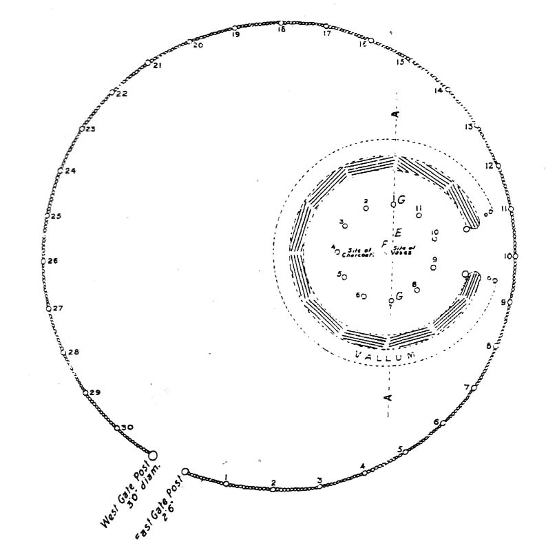
Bleasdale Ring & enclosure plan (Syd Wilson, 1900)
Pretty easy to find, and a nice walk to boot! Head up to Bleasdale Church (worth a look in itself!), keep going up the path north to the aptly named Vicarage Farm. From here you’ll notice a small copse of trees on your left (east) heading to the hills. To those of you who like Predator, “it’s up there – in them trees…!”
Archaeology & History
On my first visit here in the company of John Dixon and other TNA regulars, my first impression was “this is a henge” – and noted subsequently that it’s been described as such by several writers. But the general category given to this fascinating place is a ‘timber circle.’
Bleasdale ‘henge’ circle
First discovered at the end of the 19th century and described in considerable detail by Mr Dawkins (1900), this is a gorgeous-looking monument was erected in at once a gentle and tranquil, aswell as an imposing natural setting, at the foot of Fair Snape Fell (to the northwest) and Bleasdale Fell (due southwest). These aspects of the landscape would have had obvious mythic importance to the people who built this ring amongst the trees. A condensed version of Dawkin’s material was described in J. Holden’s (1980) Story of Preston, that outlined this circle as being,
“a centre for religious worship in about 1700 BC. It was made up of a circle of timber posts which enclosed an area 45 metres in diameter. In the centre was a small mound surrounded by a ring of oak posts and a circular ditch. Inside the mound there was a grave that had in it two pottery urns filled with human bones and ashes. Examination of the contents of these urns shows that the bodies were wrapped in linen and burnt on a funeral pyre. A small ‘accessory’ cup was found inside one of the urns and this may have contained food or drink for the afterlife.”
Urns from Bleasdale Ring1898 photo of Shadrach Jackson (left) & Tom Kelsall (centre) digging the site
Located within a much larger circular enclosure, the internal Bleasdale ‘henge’ Ring consisted of a small circle of eleven timber posts near the edge of the ditch, and an entrance way to the east, to or from which was an avenue of further wooded posts that led to the edge of the larger enclosure. It gives the impression that this was some sort of avenue along which a ceremonial procession may have took place, strongly suggesting a ritual function. Robert Middleton (1996) told that,
“The post circle and barrow appear to respect each other (in date), whilst the enclosure may be later. The post circle has been dated to around 2200 BC, although the context and reliability of this date is unclear.”
Looking out eastwards from the middle of the internal henge-style ring and through the ‘entrance’ we find an alignment with a large notch on the skyline which, modern folklore ascribes, is where the midwinter sun rises — which is very believable, but I aint seen it proven anywhere yet.
A much greater and full excavation report of this site was written by Raymond Varley (2010), whose essay I urge fellow antiquarians to read.
References:
Dawkins, W.B., ‘On the Exploration of Prehistoric Sepulchral Remains of the Bronze Age at Bleasdale,’ in Transactions of the Lancashire & Cheshire Antiquarian Society, volume 18, 1900.
Dixon, John, Journeys through Brigantia – volume 8: Forest of Bowland, Aussteiger Publications: Barnoldswick 1992.
Edwards, Ben, “The History of Archaeology in Lancashire”, in Newman, 1996.
Gibson, Alex, Stonehenge and Timber Circles, Tempus: Stroud 1998.
Holden, Jennifer (ed.), The Story of Preston, Harris Museum: Preston n.d. (c.1980)
Middleton, Robert, “The Neolithic and Bronze Age,” in Newman, 1996.
Newman, Richard (ed.), The Archaeology of Lancashire, Lancaster University 1996.
Sever, Linda (ed.), Lancashire’s Sacred Landscape, History Press: Stroud 2010.
Stone Circle (destroyed): OS Grid Reference – NY 37 50
Archaeology & History
Listed in Burl’s (2000) magnum opus, this is another long-lost megalithic ring, whose exact location seems to have been forgotten. An early description of the site by William Whellan (1860) told us that,
“There was formerly a circle of rude stones, ten yards in diameter, near the village, supposed to have been the remains of a Druidical temple; and a little distance from it, was a tumulus, three yards high and eight in diameter.”
More than a hundred years later in Waterhouse’s (1985) fine survey, he described the circle, saying:
“It lay near the village of Dalton…near the River Caldew… An 18th century account describes it as consisting of ‘rude’ stones…set in a circle of diameter about 27m. East of the the centre of the circle were four large stones lying on top of each other. They may have been the remains of a cist, or possibly a tumbled cove, like that inside the circle-henge of Arbor Low in Derbyshire. A tumulus may have stood nearby.”
There are however some discrepancies in the descriptions between Whellan and Waterhouse. In the former, the site of Chapel Flat is talked of separately as being the abode of a hermit in the lost chapel of St. Wynemius, “in a deep and romantic part of the vale of Caldew.” The description of the stone circle immediately follows this, but is spoken of as merely being “near the village.”
Does anyone know anything further about this once important site? Did the lost hermitage on Chapel Flat actually have anything to do with the stone circle?
References:
Burl, Aubrey, The Stone Circles of Britain, Ireland and Brittany, Yale University Press 2000.
Waterhouse, John, The Stone Circles of Cumbria, Phillimore: Chichester 1985.
Whellan, William, The History and Topography of the Counties of Cumberland and Westmoreland, Comprising their Ancient and Modern History, W.Whellan: Pontefract 1860.
Just below Black Hill in the Middleton Moor Enclosure, little more than 10 yards east of the footpath on the east side of Loftshaw Gill, the slope drops down and into a slight ‘bowl’ in the landscape. Here it is!
Archaeology & History
This is a previously undiscovered prehistoric settlement, enclosure, or something along those lines! We came across it in April 2005 and is found amidst the mixed heather and bracken and has a scattering of small stones, as if in the wake of a dried stream from bygone times. But whatever stream might once have been here, it’s long since fallen back to Earth — but at a point where a few rushes (Juncus conglomeratus) can be seen we find the aged remains of a large oval enclosure.
Similar in form to the other remains located up here by Eric Cowling (1946) in the 1930s and ’40s, when Richard Stroud and I first found this, structural remains of distinct lengths of walling were visible – but once the vegetation started growing back here again, it was almost impossible to discern.
Faint remains of enclosure walling
The main archaeological remains comprises of an oval-shaped structure, with what seemed liked a distinct Bronze Age note stamped on the walling — though it could be earlier, but without excavation it’s impossible to say. Most of the walling was just above ground-level, making it difficult to appreciate in the photo. It measures approximately 40 feet north-south and 33 feet east-west. The walling itself averages between 18-24 inches wide and was no more than one-foot tall at the highest. Near the middle of the enclosure there were further sections of walling indicating different ‘rooms’ in the overall structure of things here.
Like I say, we unfortunately couldn’t get a decent image of this site cos the vegetation was already covering it up. So if you wanna see it, gerrup there soon after the heather burning’s been done here — otherwise it’s gonna be at least another year before you getta chance to see anything. In Richard Stroud’s photo here, you’re looking at the bottom curve of the enclosure. You can just make out the line of walling near the centre of the picture, and two-thirds the way to the right you can see the enclosure wall curve closer to the bottom of the photo. (the site obviously requires a much better assessment from someone far more competent than me!)
References:
Cowling, E.T., Rombald’s Way, William Walker: Otley 1946.
From the little hamlet of Langbar, head up to the steep footpath to Beamsley Beacon and from there along the footpath get yourself between the giant cairn known as The Old Pike and Round Hill. About halfway between these two points the moor levels out (with brilliant views in all directions) and 200 yards southeast of the upright boundary stone, this well-defined carved rock is just a few yards north off the footpath. It seems to be just over the boundary line of Middleton Moor and onto the Beamsley Moor side (not that you give a shit when you’re up here ambling about – but the cartographers like to get things right I s’ppose!).
Archaeology & History
…and from another angleSketch of the design
Near the very top of the moor this one — this is a small carving that I rediscovered in March 2005, much of it covered in peat and heather. It’s very similar to some of the central designs found on the Baildon Moor cup-and-ring carvings, with four cup-markings (3 are deep) in a slight arc to the southern edge of this small, squared stone, very much like carvings 126 and 130 in the Boughey & Vickerman (2003) survey. However, unlike the Baildon Moor examples, no burials seem to accompany this carving—although the surrounding heather may be hiding other archaeological remains.
References:
Boughey, Keith & Vickerman, E.A., Prehistoric Rock Art of the West Riding, WYAS 2003.
We were graciously guided to this spot by local archaeological authority, Pete Glastonbury — which is good, cos otherwise it’d have probably taken us all day to find the damn thing! Best way to get here is out of the Avebury circle, east, up for about a mile up the Herepath or Green Street till you hit the ancient track of the Ridgeway. Turn left and walk up the gentle slope for another 350 yards or so, then note the footpath on your right. Go down the slope for about 150 yards, keeping your eyes peeled for the smooth rock with the slits in it, not far from the Holed Stone!
Archaeology & History
Although classified on the Wiltshire Sites & Monuments Record as an “unclassified feature,” this is one of a number of whetstones (as we call ’em up North) that feature in various settings in and around the Avebury region: literally, a rock used for sharpening axes, daggers and other metallic artifacts. First rediscovered in the spring of 1963 by a Mr Inigo Jones when he was out exploring the many rocks hereby for rare lichens and any more cup-markings like the one at nearby Fyfield Down, the site we see today is merely a long piece of stone with five or six long lines or grooves cut into the top-end, along which the ancient weapons and tools slid and cut into the rock, sharpening them.
It was thought until recently that this was the prime function of this stone; but following excavation work done here by Pete Fowler and his team in 1963, it seems that the stone actually stood upright! Digs were made on three sides of the stone and some earlier disturbance seemed apparent:
“The material appeared to be redeposited on top of an earlier ground surface, inferentially of medieval or earlier date. At the north end of the sarsen bench, the lip of a pit or trench was partly excavated. It showed clearly in plan as a feature dug into the top of an undated surface level with the disturbed top of the clay-with-flints; it was filled with flinty, clayey humus similar to that through which it was cut. In the top of that fill was a heavily weathered sarsen, c 0.6m by 0.45m, and a cluster of smaller, broken sarsen stones. The hole was at least 0.45m deep, its bottom as excavated marked by an increase in the density of flints. The evidence, though incomplete, suggested very strongly that the feature was part of a hole dug to take the pollisoir as an upright stone.” (my italics, Ed)
In the same dig, a medieval coin of King John (1199-1216) and the remains of a medieval horseshoe were found beneath the stone, giving Fowler and his team the notion that the stone had been split and pushed over at this period. Consistent evidence of activity from the neolithic period onwards was expected and found here.
In Lacaille’s (1963) original description of the site, he gave a most accurate description of the dimensions of the stone and its incisions. Highlighting its proximity to a cluster of other stones, as well as being close to a wide ditch, Lacaille’s measurements were thus:
“From 1ft (0.31m) above ground at its south end the regular surface of the sarsen slopes to the grass, its main axis being aligned about 15° west of the true north and south line. In length the stone measures 5ft 6in (1.68m) above the grass, and 2ft 10in (0.86m) in width.
“Closely grouped in the south-eastern corner of the sarsen there are six hollows. In plan the largest and southernmost is of long elliptical shape, 1ft 8in (0.5m) long and 9in (0.23m) at widest and 1in (0.0254m) deep. From its wider end near the eastern long margin there protrudes a short groove. Beside this, and curving slightly inward, there is another groove, 1¼in (0.028m) wide and ½in (0.013m) deep. It is as long as the large basin-like cavity. Next to it there runs one of similar length and width, but of only half the depth. In turn, a third groove, ½in (0.013m) wide, 1ft 8in (0.5m) long, has been worn at right angles to the long edge but to a much deeper hollow than its companions. At 2in (o.051m) to the north a lesser version of the main basin occurs. Like this it measures 1ft 8in (0.5m) in length, but is only 2¼in (0.058m) wide and ¾in (0.016m) deep. Vague in places over its interior length of 10in (0.25m), but attaining a maximum width of 1¼in (0.028m), a last hollowing shows faintly at both ends and nowhere deeper than 1/8in (0.0032m).”
The Polisher & its marksCeloria & Lacaille’s 1963 drawing of the stone
It appears that this fallen standing stone was being used to sharpen knives and axes whilst it stood upright and, in all probability, as a result of this ability would have been possessed of magickal properties to our ancestors. Metalwork was an important province of shamanism and smiths, whose practices were deeply enmeshed in the very creation of mythical cosmologies. Hence, the simple act nowadays of sharpening metal tools onto rocks would not have been a mere profanity to the people who came and used this stone to re-empower their weapons, but would have been entwined within a magickal cosmology. The spirit inherent in this stone would likely have been named and recognised. Today it is forgotten…
It also seems that this standing stone was part of some ancient walling. Aerial views clearly show it along the line of some sort of enclosure that runs down the slope, along the bottom and back up and around. In the same stretch of this enclosure walling we find the Holed Stone a little further down the slope. And holed stones, as any student of folklore and occult history will tell you, have long-established magickal properties of their own…
References:
Fowler, Peter, Landscape Plotted and Pierced: Landscape History and Local Archaeology in Fyfield and Overton, Wiltshire, Society of Antiquaries: London 2000.
Grigson, Geoffrey, The Shell Country Alphabet, Michael Joseph: London 1966.
From the Avebury stone circle, walk out eastwards and straight up the ancient Ridgeway for about a mile until it levels out and meets up with the adjoining track upon the hilltop. Instead of going left or right, go straight across and onto the footpath that crosses Overton Down, until you reach the wide horse-racing track lookalike called ‘the Gallops.’ Stop – don’t go on it – and follow the fence down for a coupla hundred yards till you’ll see the fenced-off rise with a modern ‘barrow’ enclosed within. You’re very close! From here, go another 100 yards or so down and keep your eyes on the rise of land with rocks scattered around it. That’s it!
Archaeology & History
From all accounts, there’s been nowt of any consequence written about this site — which is bloody incredible to be honest!! We came here on a fine day (that’s Mikki, Geoff and June) in the company of the local Avebury magus, Pete Glastonbury. Crossing Overton Down towards an experimental “barrow” that some archaeo’s have knocked-up, the rise in the land here stands out quite clearly, saying (at the very least), “look at me!” But until Pete Fowler (2000) first described this “unrecorded kerbed round barrow” a few years back, it had escaped the noses of all previous archaeological surveys! How!?
What the hell do archaeologists in the Avebury area do with themselves if they can’t pick this sorta monument out!? But anyway…
Overton Down cairn – looking NW
This is quite a large rounded cairn structure by the look of it. At least 30-feet across, probably kerbed from the initial look (only for a few minutes, sadly). Local writer Terence Meaden has apparently found the site of some importance in his studies (not yet published). Its position here in the landscape was what caught my attention more than anything: it stands on the crest of the hill and has superb uninterrupted views far across the Avebury landscape. This siting was obviously quite deliberate. Less than 100 yards due north of here are two curiously placed stones which may ‘frame’ the cairn for a southern lunar alignment. I had no time to look at this really, so it would be good if some local Avebury dood could check this out. The outlying stones may be merely fortuitous, but it’d be good to know for sure!
The site has been plotted amidst a mass of landscape changes dating from the neolithic to medieval periods. It seems probable, on first impression, that the ‘cairn’ is of Bronze Age in character (though could be earlier), but until detailed analysis has been made we obviously won’t know for sure. A short distance to the south we have the much-denuded Overton Down site X1: another Bronze Age burial that yielded three beaker graves when Fowler excavated the place in the 1960s.
For those of you into geomancy, meditation and the subjective realms of genius loci, this one really grabbed me. Give it a go and lemme know what you get. But please, no stupid pagan or New Age offerings — the site doesn’t need that sorta thing.
References:
Fowler, Peter, Landscape Plotted and Pierced: Landscape History and Local Archaeology in Fyfield and Overton, Wiltshire, Society of Antiquaries: London 2000.
Dead easy this. From Otley, take the north road over the River Wharfe and turn left following the signs to Askwith, where you’ll hit Weston village first. Once here, take the small left turn down to Weston Hall and the accompanying church. Go into the churchyard and check the graves!
Archaeology & History
This is a real curiosity. It’s found in the graveyard of All Saints church, Weston, where one of the graves has several small stones on it, with this small stone with the following cup-and-ring designs upon it. A plaque has been attached to it as a memorial to one ‘Susan Mary Dawson’. Strange…
Sid Jackson’s 1958 sketchCup-marked stone deliberately placed on a christian grave
It was first written about by Sidney Jackson (1957), but where it first came from and why it has been placed here in a christian setting is something of a mystery. It’s also odd inasmuch as although we know that there was some form of ritual or geomantic use of cup-and-rings in relation to neolithic and Bronze Age burials — that such a tradition has been performed by this particular family on this grave. It is obviously highly unlikely that this family had any knowledge whatsoever of burial traditions in relation to cup-and-ring art (please, shoot me down in flames if you know otherwise), so this re-use of this prehistoric stone is likely to be little other than fortuitous. But then, the occult history of some of the influential families in and around this region in relation to witchcraft, ancient kingship and esoteric practices, might indicate otherwise…
Does anyone know anything about the Dawson family history which might throw light on this modern use of a prehistoric tomb marker? It has all the hallmarks of once coming from a prehistoric cairn, but we know little of its history prior to 1957.
References:
Boughey, Keith & Vickerman, E.A., Prehistoric Rock Art of the West Riding, WYAS 2003.
Jackson, Sidney, ‘Cup-and-Ring Boulder, Weston Churchyard,’ in Cartwright Hall Archaeology Group Bulletin, 2:16, 1957.


 References:


")

")
