Bull Spring, Staining, Poulton-le-Fylde, Lancashire

Sacred Well:  OS Grid Reference – SD 35569 36707

Getting Here

The boggy ground of the Bull Spring - from the site of possible cairn
The boggy ground of the Bull Spring – from the site of possible cairn

To get here, leave Staining village along Mill Lane, turning right at the windmill along Smithy Lane.  Walk along Smithy Lane, then 2-300 yards past a derelict piggery on the left go into the gated trackway on the right, and Bull Meadow is to the south-east, a boggy area at the western end of OS parcel 356.  Be prepared to cross barbed wire fences.

Archaeology & History

Like the Staining Wrangdomwell or Fairy Spring recorded elsewhere, knowledge of this site owes its historical survival to the writings of Blackpool cleric, Rev. William Thornber (1803 – 1885), who wrote in 1851 about the now forgotton ‘Teanla’ or Hallowe’en bonfire cairns of Hardhorn:

“…but here adjoining the cairns are attached two wells, the one celebrated as Fairy or Wrangdomwell, and the other, issuing from a huge oblong mound of stones, as Bel spring or vulgarly Bull spring, in the Bull meadows, evidently bearing the same name as Beltain Meadow in Blackpool.  Here on this Hardhorn oblong cairn, ceremonies were observed for the purpose of obtaining health to the herds of the farmers of the township – to free the wheat-land from tares, weed &c. – to bring good luck to the votaries, and to enquire into the secrets of futurity.

The ceremony was thus:- first, large fires were lighted, two or three families joining at a circular cairn, the ashes of which were carefully collected. Then the white stones, which at first, had circled the fire were thrown into the ashes, and being left all night, were sought with anxious care at sunrise, when the person who could not distinguish his own particular boulder was considered fey, i.e. some misfortune would happen to him, during the course of the ensuing year¹.

As a finale, the stones recognised were thrown, as an offering, on the oblong cairn to the god or saint who presided over it, and the well, and thus, such collections were made in a succession of years, as to astonish the curious. The water of the wells also had a sovereign virtue for healing the disease of men and cattle….”

The healing procedure at the wells is transcribed in the description of the nearby Fairy Well. Mr Thornber continues:

“The site of the large circular cairn (at Bull Meadow) is not now easily to be distinguished, since Mr. Fisher, the proprietor of the field, has carted away upwards of twenty loads of the refuse that composed it, but the soil around it is burnt red and black. This farce was carried on in its pristine glory long after the reformation; for rational Christianity (sic), which had been almost lost previously, progressed but slowly in the district of the Fylde. Even the waters of Marton Mere (SW of Bull Meadow),…were held sacred.”

Perusal was made of the Schedule to the 1839 Tithe map which revealed a ‘Bull Meadow’, owned and occupied by William Fisher, and from this, its location was able to be identified on the OS map.

Possible source of the waters

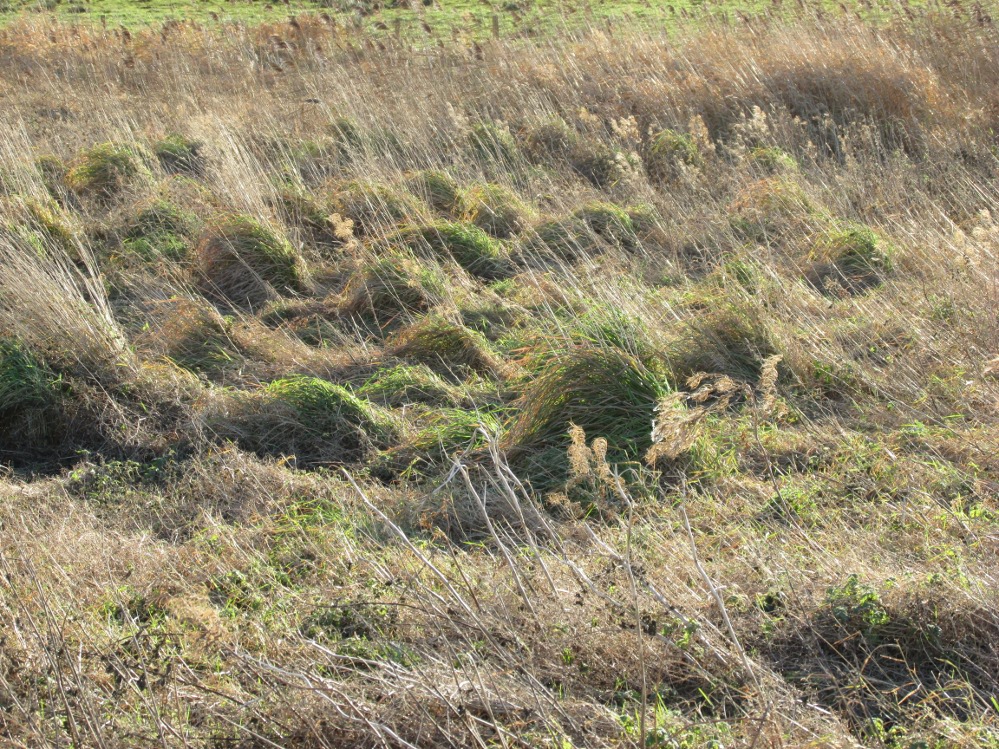
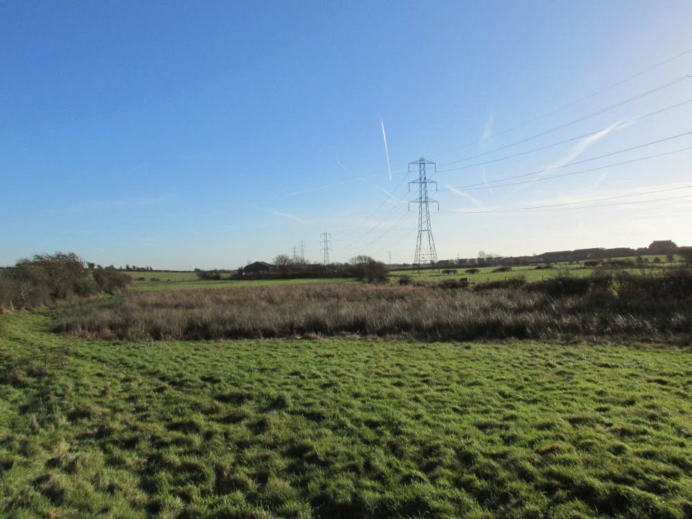
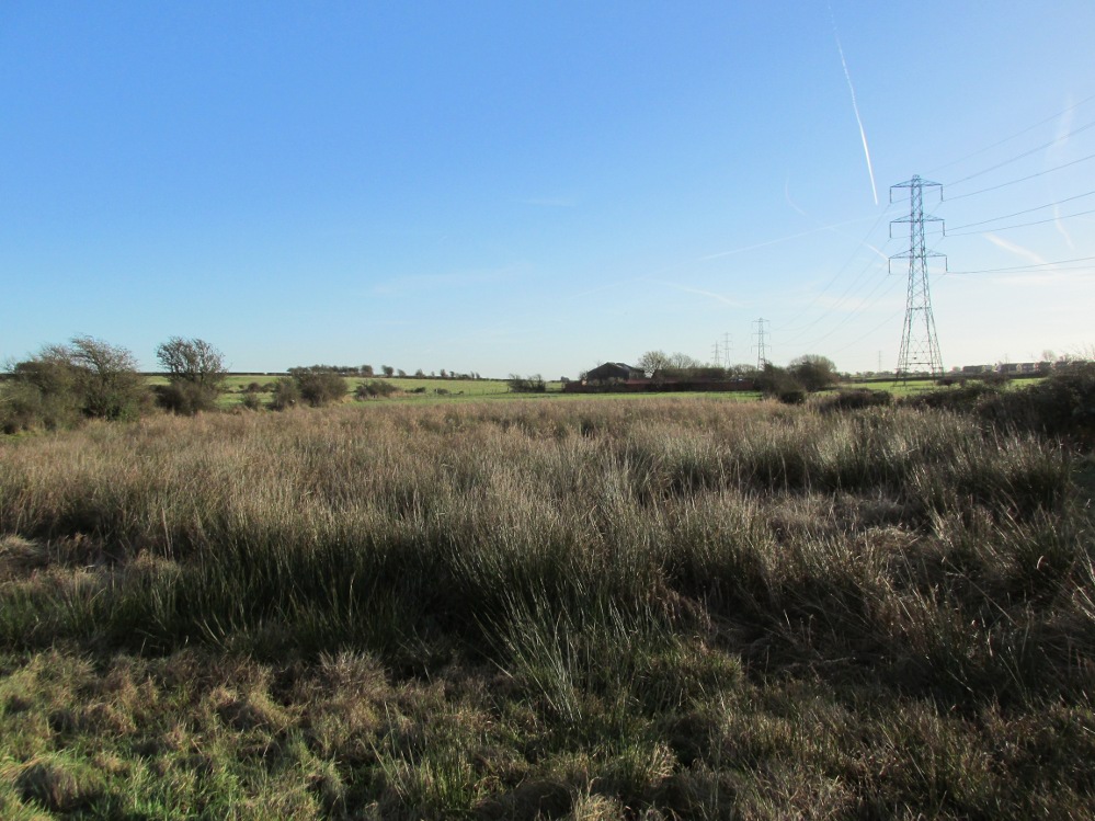
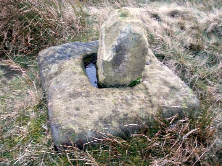
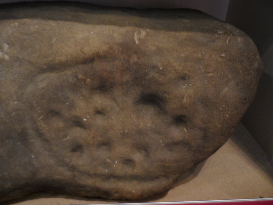
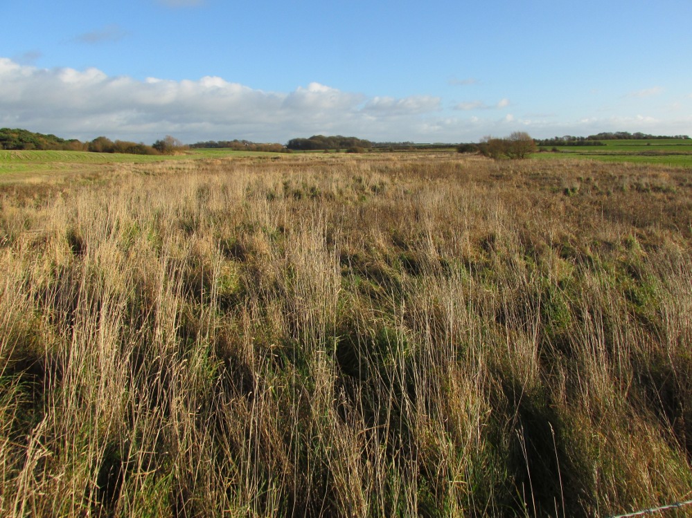
Like Wrangdom Well, half a mile to the north-west, the Bull Spring issues from an area of swampy ground, and the exact place of issue was hard to pinpoint when this writer visited in December (see photo the right).  The oblong cairn—if indeed that is what it is—can still be identified, about 2 feet above the marsh, it is firm to stand on but not easy to distinguish owing to the amount of vegetation.

¹ Writing in the January 1883 edition of the The Folk-lore Journal, the Reverend Walter Gregor describes ‘ristin the halla-fire’ a broadly similar Scottish ritual carried on in the Fraserburgh area up to the late 18th century.

References:

  1. Thornber, William, ‘Traces of the Britons, Saxons and Danes in the Foreland of the Fylde,’ in Proceedings and Papers of the Historic Society of Lancashire and Cheshire, Liverpool 1852.
  2. Tithe Map & Schedule Transcript – ‘The Township of Hardhorn with Newton’ Surveyed by Thomas Hull in 1838, with Schedule dated 1839.’

Acknowledgement:  My thanks to the staff of the Local Studies Department, Borough of Blackpool Library Services for their assistance.

© Paul T. Hornby, The Northern Antiquarian


Fairy Well, Staining, Poulton-le-Fylde, Lancashire

Sacred Well:  OS Grid Reference – SD 34908 37119

Also Known as:

  1. Wrangdom Well

Getting Here

The site of the Fairy Well, Staining

One and a half centuries of neglect have not been kind to the Wrangdomwell, which is now in the middle of a large area of swampy land, reached from Staining village along Mill Lane, turning right at the windmill then walking along Smithy Lane.  Just before a derelict piggery on the left go into the field, and Wrong Well Meadow is on the right at the back of the piggery, with the spring issuing from the boggy ground. Be prepared to cross barbed wire fences, and to meet some friendly ponies.

Archaeology & History
Were it not for the researches and writings of an eccentric cleric, this site would almost certainly now be lost to history.  The Reverend William Thornber recorded, in his 1837 History of Blackpool that:

“The fairies of our fathers…were kind good natured creatures, at times seeking the assistance of mortals, and in return liberally rewarding them. They had a favourite spot between Hardhorn and Staining, at a cold spring of water, called Fairies’ Well to this day.”

The legendary waters hide in the rushes

Writing in a paper published in 1851, Thornber described the Fairy Well or Wrangdomwell in the context of the “Teanlas”, the enormous Hallowe’en bonfires (4) that were still at that time being lit at ritual cairns of stones in parts of west Lancashire.  One of these fire cairns once adjoined the Fairy Well, which in 1850 was still being visited for its,

“sovereign virtue for healing the diseases of men and cattle.  To succeed in obtaining a cure, the patient, escorted by his friends, was made to pass through the cairn, then he was sprinkled or dipped in the well, and lastly, he made an offering of a shell, pin, a rusty nail or a rag, but principally three white stones burnt in the Teanla fire. It is surprising in what numbers pieces of iron may be picked up. I have found since the meadows were ploughed, nails, an old shaped knife, leather thongs etc.”

Thornber wrote that the cairn no longer existed, and gave no precise location for the well.

Looking at the area between Hardhorn and Staining on the 1891 25″ OS map revealed only one ‘spring’; in land parcel 295. This parcel of land is recorded in the Schedule to the 1839 Tithe map as ‘Wrong Well Meadow’, occupied by Thomas Dobson, and owned by ‘School of Marton’, a charitable endowment established in 1717.  Adjoining Wrong Well Meadow are Old Meadow and Nickers Meadow (‘Old Nick’?), which might appear to show the Wrangdomwell as in the past having been part of a larger heathen ritual locality. Notwithstanding this, the Church was happy to take its tithe.

References:

  1. Thornber, William, The History of Blackpool, Smith Market Place: Poulton-le-Fylde 1837 (republished in 1985 by the Blackpool and Fylde Historical Society).
  2. Thornber, William, ‘Traces of the Britons, Saxons and Danes in the Foreland of the Fylde,’ in Proceedings and Papers of the Historic Society of Lancashire and Cheshire, Liverpool 1852.
  3. Tithe Map & Schedule Transcript, ‘The Township of Hardhorn with Newton’ Surveyed by Thomas Hull in 1838, with Schedule dated 1839.’
  4. Michelle Harris & Brian Hughes, in their ‘The History of the Wyre from Harold the Elk to Cardinal Allen‘ (4th ed. 2007) p35, write – “According to Tom C. Smith’s ‘History of the Parish of Chipping‘ published in 1891: ‘Teanlaes was the name given to fire celebrations, observed until quite recent years on May 1st, Midsummer Day, August 31st, and November 1st.’ These dates, it should be said, are at variance with Henry Taylor who, in his 1899 publication ‘Ancient Crosses of Lancashire’, quotes Atticus as saying: ‘The ceremony observed on Teanlow night, the last night of October, consisted of making bonfires on all the neighbouring hills.'”

AcknowledgementsMy thanks to the staff of the Local Studies Department, Borough of Blackpool Library Services for their assistance.

© Paul T. Hornby, The Northern Antiquarian


Ring Stones Hill, Catlow, Nelson, Lancashire

Stone Circle (destroyed?):  OS Grid Reference – SD 892 367

Archaeology & History

Set in good landscape with fine views in most directions, it seems that the only thing that remains of this site is a place-name on a map—but I have to say that our search here was only a short one, and so more may be found hiding away in field walls or beneath the ground.  However, if we listen to an early account of the place, it was said to have “completely gone by 1856.”  A pity, as it was described as being “a large circle of stones.”  The monument was used for repairing the nearby road and, in another account, we are told that the stones were added to the walls.  Whether this was a cairn circle or a free standing stone circle isn’t known.  The prevalence of tumuli close by at Catlow, Burwains, etc, would suggest a cairn circle, yet we have no accounts of human remains here… A puzzle.

References:

  1. Barnes, Bernard, Man and the Changing Landscape, Liverpool University 1982.

© Paul Bennett, The Northern Antiquarian


Strowan, Crieff, Perthshire

Tumulus:  OS Grid Reference – NN 81998 20832

Also Known as:

  1. Canmore ID 25510

Getting Here

The faerie mound of Strowan

If you’re coming southwest out of Crieff on the A822, as you cross the river take the right-turn just before leaving the town along the country lane onto Strowan and Dalginross.  Nearly 2½ miles along there’s the small junction on your right to Strowan House and church. Just past this turning, the next field on by the roadside, has a large rounded tree-covered mound living quietly. That’s the fella!

Archaeology & Folklore

Found halfway between Crieff and Comrie in the field on the north-side of the road, this large oak-covered tumulus was, seemingly, first described in notes made by the old archaeologist O.G.S. Crawford following a quick visit he made here in 1936.  The place has, since then, never been excavated to find out exactly what might be hiding therein!  It’s quite a big fella too: about 10 feet high and 40 yards across (east-west)—similar in size and design to the prehistoric burial mounds at Tulloch and Kinpurnie.  Some large rocks make up the sides and edges of the mound, with smaller ones scattered here and there, giving the distinct impression of a very overgrown cairn of sorts.

Tis a quiet and tranquil arena, amidst fervent colours of meadows and old trees. Another 2 miles further down the same road is the equally tranquil (though ruined) megalithic ring of Dunmoid

© Paul Bennett, The Northern Antiquarian


Coombe Hill Cross, Wycoller, Lancashire

Cross:  OS Grid Reference – SD 95586 38608

Also Known as:

  1. Combe Hill Cross

Getting Here

Coombe Hill Cross, Lancashire (photo credit, Ray Spencer)
Coombe Hill Cross (photo by Ray Spencer)

Along the high moorland road between Laneshaw Bridge up towards Oakworth, on the Lancashire side of the moors a half-mile before reaching the Watersheddles reservoir, past the derelict pub until you reach the isolated Coombe Cross farmhouse on the tops.  Across the road from here is a boggy footpath leading onto the moors.  Walk on here for 100 yards, where the path bends left and another footpath veers up higher onto the moors.  Walk up here for 20 yards and you’ll see the small monolith 10 yards away in the grassy heaths on your left.

Archaeology & History

Taylor's 1906 drawing
Taylor’s 1906 drawing

Found on the old route between the counties of Yorkshire and Lancashire, this little-known wayside cross has seen better days.  Found in relative isolation from other monuments by the ancient trackway (Herder’s Cross is a mile WNW, and the curious Water Sheddles Cross a mile east), its history is quiet and it was ignored in the general surveys of such monuments by Rimmer (1875), Tyack (1900) and Vallance. (1920)  Thankfully the giant survey of Henry Taylor (1906) did not forget it—although he seemed to know little of its story, merely telling us,

“The base-stone and part of the upright shaft of this cross stand about one hundred yards in a south-easterly direction from (Far Combe Hill Cross)… Two hundred yards south of the Combe Hill Cross occur the words, ‘Cross Bent.'”

Coombe Hill Cross (photo by Ray Spencer)

The near-square stone base—about 3 feet by 3 feet—is commonly ascribed as medieval in origin and it’s thought that the remaining upright cross-stump—over 2 feet high—is probably not the original one. When fellow antiquarian Ray Spencer visited the site recently, he reported there to be “a faint inscription on the base saying COMBE HILL CROSS.”

The most detailed account of this monument was to be found in Clifford Byrne’s (1974) unpublished paper on the antiquities of the region, where he wrote:

“The pedestal of this cross with a piece of stone sitting in it which may or may not be part of the original monolith is situated on a wayside hillock… On passing the Herders Inn above Emmot, scrutiny of the left hand side of the road at the top of the next rise ahead opposite a white farmhouse will show what looks like a stumpy finger pointing to the sky.  Close inspection will show that at the site sits the pedestal of a cross, apparently settled on two steps.  Note that the pedestal and the supporting stones beneath have a remarkable resemblance to Carlton Cross which stands on Cross Green between Tom Cross Ainslack and Carleton village near Skipton.  It may be that both monoliths were erected by the same hands.  Whether the supporting blocks beneath the pedestal were for purposes of kneeling, or merely to stop the edifice sinking into the moor is…open to dispute.  An ancient track passes the cross site where it splits into two: one going east towards Keighley and  the other going south towards Haworth by Watersheddles Cross.  A continuation of the track westwards travels along the foot of Boulsworth Hill past Iron Age burials,* along a fine set of pack horse setts, past standing stones, old lime kilns, and eventually leaving behind some remains of the Wycoller Vaccary stones near Antly Gate Farm.  It tops the brow of a hill and drops down through Thursden by the Cold Well itself a a little green gate in the reservoir wall. Marquis of Colne suggested that the Combe Hill Cross dates from the time of King Stephen in the 12th century, but does not say on what he based his surmise…. If the origin of the stone is dated correctly, it has stood near Colne for over 800 years.”

References:

  1. Byrne, Clifford, A Survey of the Ancient Wayside Crosses in North-East Lancashire, unpublished 1974.
  2. Taylor, Henry, The Ancient Crosses and Holy Wells of Lancashire, Sherratt & Hughes: Manchester 1906.

These Iron Age burials may be Bronze Age as we have found remains of several hut circles dating from that period in this area. PB.

AcknowledgementsHuge thanks to Ray Spencer for use of his photos and additional data for this site profile.

© Paul Bennett, The Northern Antiquarian


St. David’s Well, Weem, Aberfeldy, Perthshire

Holy Well:  OS Grid Reference – NN 8445 5002

Also Known as:

  1. Canmore ID 25672
  2. Chapel Rock Spring
  3. Fuaran Creig a’ Chaibeul
  4. St. Cuthbert’s Well

Getting Here

In the dark, dark wood... hides St. David's Well
In the dark, dark wood… hides St. David’s Well

The best way to find this site, in the middle of the large woods up the slopes, is to follow the circular mile-long tourist path that runs through it. Take the B846 road out of Aberfeldy over the bridge towards Dull and Weem.  As you go through Weem, watch closely for the signpost directing you into the trees of Weem Rock and Woods on the right. Follow this tiny road up until you reach the parking circle in the edge of the trees.  Follow the directed footpath up into the woods & keep to the winding track, up, zigzagging, and up again, until it levels out a bit and runs below the large long crags. Tis beneath here you need to be!

Archaeology & History

The pool of St David's Well
The pool of St David’s Well

Not far from the curious Weem Wood carvings, hidden beneath one section of the long high crags in remains of the ancient forest, is this trickle of fresh water which collects into a small stone-lined pool. (a small round plaque which reads ‘St. David’s Well’ on the cliff-face above the waters is helpful) It’s in a truly lovely setting, with a small ‘cave’ about 50 yards west along the same footpath and a modern carved ‘cross’ in front of it.

The well was formerly known as St. Cuthbert’s Well (date: 20 March) who, so legend tells, lived nearby—probably at the christian-druid college at Dull, a mile west of here. It was he who collected the waters from the rock face into the small pool we see today.  This used to be known as St. Cuthbert’s Bath.  But several centuries after the saint’s death, the local laird, Sir David Menzies, came and restored the well and gained a reputation for spending much time living hereby, sometimes in the small cave along the edge of the cliffs.  It was to him that the New Statistical Account wrongly dedicated the waters to in the 19th century—but the title has stuck!

Described in several old local history works, the site was included in the giant folklore tome on Scottish waters by MacKinlay (1893), who wrote the following:

“In the wood clothing the steep hill of Weem, in Perthshire, is St. David’s Well, said to be named after a former laird who turned hermit.  The spring has a considerable local fame, and many have been the wishes silently breathed over its water.  Part of an ancient stone cross lies at its margin, and on it the visitor kneels while framing his or her wish.”

Nothing of this ‘cross’ can now be seen, but it is said that its remnants are housed at Weem church in the village below.  Also in the 19th century, occasional christian gatherings were held here and as many as fifty people came “for religious services.” Thomas Hunter (1886) reported that “a collection of human bones” were found near the well in front of the crags. There is also what looks like a newly cut large cup-marking with two carved lines reaching out from it, heading towards the well, on a small ledge of stone close to the pool.

Folklore

Folklore tells that once, long ago, dragons lived in these old woods—overcome no doubt by the incoming christians who stole and denigrated the olde peasant ways of our ancestors.  In bygone times, locals used the waters here for their health-giving properties.  As Ruth and Frank Morris (1982) told,

“it was an ancient wishing well which was still visited in 1954, when such objects as pins and buttons and an occasional penny was thrown in.”

References:

  1. Ferguson, Malcolm, Rambles in Breadalbane, Thomas Murray: Glasgow 1891.
  2. Hunter, Thomas, Illustrated Guide to Perthshire, Robertson & Hunter: Perth 1886.
  3. MacKinlay, James M., Folklore of Scottish Lochs and Springs, William Hodge: Glasgow 1893.
  4. Morris, Ruth & Frank, Scottish Healing Wells, Alethea: Sandy 1982.

© Paul Bennett, The Northern Antiquarian


Ball Cross Carving 02, Bakewell, Derbyshire

Cup-and-Ring Stone:  OS Grid Reference – SK 231 691

Archaeology & History

Ball Cross 2 Carving (after Beckensall)

One of three carvings that were located inside the walling of the Ball Cross hillfort during excavations here in the early 1950s by J. Stanley. (1954)  Each carving is distinctly unlike the other in design (see Ball Cross 1 and Ball Cross 3) and it’s highly probable that they were incorporated into the Iron Age structure with their original mythic functions—of neolithic or Bronze Age origin—disused. It is not unlikely that this and its compatriots were originally found in association with the nearby prehistoric tombs.

Ball Cross 2 Carving (photo by Dean Thom)

The broken piece of rock consists of a broken section of an almost archetypal ‘cup-and-ring’—although with this design, no central ‘cup’ occurs: a pattern found at several other multiple-ring stones, like the Grey Stone near Leeds.  Although Stan Beckensall (1999) described this to have “8 concentric rings”, his drawing and the photo here by Dean Thom, clearly show only seven such ‘rings’.  The carving presently lives in a protective box in Sheffield Museum (though beware the listing they give of the designs, as some are incorrect).

References:

  1. Barnatt, John & Reeder, Phil, “Prehistoric Rock Art in the Peak District,” in Derbyshire Archaeological Journal, 102, 1982.
  2. Beckensall, Stan, British Prehistoric Rock Art, Tempus: Stroud 1999.
  3. Beckensall, Stan, Circles in Stone: A British Prehistoric Mystery, Tempus: Stroud 2006.
  4. Cooper, Ali, Archaeology Walks in the Peak District, Sigma: Wilmslow 2010.
  5. Morgan, Victorian & Paul, Rock Around the Peak, Sigma: Wilmslow 2001.
  6. Stanley, J., “An Iron Age fort at Ball Cross Farm, Bakewell,” in Derbyshire Archaeological Journal, volume 74, 1954.

Acknowledgements:  HUGE thanks to Dean Thom for the use of his photo, plus helpful references on this site.

© Paul Bennett, The Northern Antiquarian


Ball Cross Carving 01, Bakewell, Derbyshire

Cup-and-Ring Stone:  OS Grid Reference – SK 2310 6911

Archaeology & History

Ball Cross 01 Carving (photo © Dean Thom)

This is another carving (one of three here) that was removed from its landscape setting when found during excavations of the Iron Age hillfort of Ball Cross in the 1950s, and then placed into a box in Sheffield Museum, decontextualizing it and leaving future researchers slightly in the dark as to its possible nature.  In removing the carving from its site, the stone was left with additional scratches and grooves slightly damaging the stone.  Not good!

Ball Cross Carving (after Beckensall)
Ball Cross Carving (after A. Cooper)

Although unlike the Ball Cross 2 and 3 carvings, the design here is structurally very similar to that found east of Gardoms Edge, with this one comprising of a large unbroken carved oval, with at least twelve cup-marks inside.  Or as Beckensall (1999) described, it “has 12 cups inside a flattened ring.”  Again, like the Gardoms Edge carving, a single cup-mark was etched outside of the enclosed ring. It was found with its companion carvings built into the main walled structure of the hillfort.  It’s unlikely that the stones date from the same age as the hillfort: more probable that they were re-used in the structure, with their mythic nature perhaps already long forgotten…

References:

  1. Barnatt, John & Reeder, Phil, “Prehistoric Rock Art in the Peak District,” in Derbyshire Archaeological Journal, 102, 1982.
  2. Beckensall, Stan, British Prehistoric Rock Art, Tempus: Stroud 1999.
  3. Beckensall, Stan, Circles in Stone: A British Prehistoric Mystery, Tempus: Stroud 2006.
  4. Cooper, Ali, Archaeology Walks in the Peak District, Sigma: Wilmslow 2010.
  5. Morgan, Victorian & Paul, Rock Around the Peak, Sigma: Wilmslow 2001.
  6. Stanley, J., “An Iron Age fort at Ball Cross Farm, Bakewell,” in Derbyshire Archaeological Journal, volume 74, 1954.

Acknowledgements:  HUGE thanks to Dean Thom for the use of his photo, plus helpful data on this site.

© Paul Bennett, The Northern Antiquarian


Gardoms Edge 02, Baslow, Derbyshire

Cup-and-Ring Stone:  OS Grid Reference – SK 2752 7328

Archaeology & History

Gardoms Edge 2 carving, in Sheffield Museum (photo - Dean Thom)
Gardoms Edge 2 carving, in Sheffield Museum (photo – Dean Thom)

This carving is one of two cup-and-ring stones that were removed from this area and transported to Sheffield Museum, decontextualizing them from their landscape presence (this should not be done unless very severe damage is happening, or their destruction is imminent).  It’s quite an intriguing carving, similar in design to one found not far away at Great Hucklow, the Middleton Moor 479 carving, etc.  Like many Pennine cup-and-ring stones, it was located in a prehistoric cairn field (or necropolis), with hut circles not far away too, and really should have remained in situ for the benefit of future researchers.

Gardoms Edge carving (after Beckensall 1999)

The carving was cut into one end of a small rock and comprises of a singular unbroken, large oval, within which are enclosed thirteen or fourteen cups, plus a single cup on the outside of the ring.  Lunar associations may be invoked by the 13 cups, enclosed within one cycle of the year.  But I’m speculating of course.  It’s probable that other carvings in the area remained undiscovered.

References:

  1. Barnatt, John & Reeder, Phil, “Prehistoric Rock Art in the Peak District,” in Derbyshire Archaeological Journal, 102, 1982.
  2. Barnatt, John & Robinson, F., “Prehistoric Rock Art in Ashover School and Further New Discoveries Elsewhere in the Peak District,” in Derbyshire Archaeological Journal, 123, 2003.
  3. Beckensall, Stan, British Prehistoric Rock Art, Tempus: Stroud 1999.
  4. Beckensall, Stan, Circles in Stone: A British Prehistoric Mystery, Tempus: Stroud 2006.

Acknowledgements:  HUGE thanks to Dean Thom for the use of his photo here.

© Paul Bennett, The Northern Antiquarian


Weem Woods, Dull, Aberfeldy, Perthshire

‘Cup-and-Ring’ Stones:  OS Grid Reference – NN 841 499

Getting Here

Looking out from the Weem Wood carved rocks

Take the B846 road out of Aberfeldy over the bridge towards Dull and Weem.  As you go through Weem, watch closely for the signpost directing you into the trees of Weem Rock and Woods on the right. Follow this tiny road up until you reach the parking circle in the edge of the trees.  Follow the directed footpath up into the woods & keep to the winding track, keeping your eyes peeled for the first large rocky crag above you, with a huge tree growing out of the edge. Once you get to the top of the steps and onto these crags, look right in front of you!

Archaeology & History

The nearest ‘officially recognised’ cup and ring carvings to the one we’re gonna see here, are those described by Kaledon Naddair (1990) in his brief descriptions of the Glassie Farm carvings a short distance northeast in the same woods.  Other than that, I can find no account of the carvings I’m about to describe – other than a couple of short local history walking guides, which tell that one of the carvings here is “modern.”  And that much is plainly evident.

Close-up of one section of the main design

There are at least seven carved stones here – all very close to each other on the top of an impressive crag with a large old tree growing out of the edge of the cliff.  But the carvings are located on the flat ground above the cliffs and, it would seem, may well be modern.  But I thought that since there are no accounts of the site on-line and no remarks in the Canmore registers, they should be mentioned as future students may mistake them as ancient.  There is the possibility (unless someone can show us otherwise) that one or two of them are prehistoric, but I think it’s best we surmise that they are all recent additions in the landscape for the time being.  And damn good designs they are too!

The triangular rock designs

The first and most notable of the group of seven (at least), is on the large earthfast triangular flat rock, pointing out to the cliff’s edge and the hills across the valley.  This is where the greatest cluster of multiple cup-and-rings can be seen.  Double- and triple rings surround several of the central cup-markings, with the traditional lines running out from the central cup.  There are a great number of single cups scattering the surface; and we also find a typical ‘rosette’ element, comprised of a central cup surrounded by eight singular cups, which some students have interpreted as solar and lunar symbols (amongst other things) when found on other carvings (there is a prehistoric Rosette Stone is known on Ilkley Moor; but similar examples are known in Ireland, Northumberland and elsewhere).

Below this triangular rock (perhaps attached beneath the) is another long piece of earthfast stone, with more carvings on. But when Lindsey Campbell and I came here yesterday, it was obvious that some elements along this section of stone were carved in recent years.  Two double-cup-and-rings are at the bottom-left of this section of rock, with a scattering of other cup-marks reaching across its surface. Several of these are obviously quite new.

Another multiple cup-and-ring

The third notable example is to the top-right of the triangular rock.  This stone is mainly of quartzite rock, apart from near the top-end, where another multiple cup-and-ring (four, with a possible fifth broken ring fading away) stand out very blatantly.  This carving also seems to be not that olde…

From this third quartz carving, look 10 yards (if that!) back towards the trees and there’s a large boulder.  On the surface of this is another multiple cup-and-ring that was very obviously new, and several other cup-markings, also quite new.  I presume that the other sections carved onto this stone have also been etched by the same modern artists.

Another boulder with new carvings

As I looked back to the main triangular carved stone, I noticed other small pieces of stone peeking up from the ground and, upon closer inspection, found one small rounded triangular piece with another multiple cup-and-ring that just fit onto the rock.  And close by this was another long piece of stone which, when I rolled the turf gently back, found three simple cup-markings along the surface.

A seventh carving was found on one of the rocks that is falling slightly down the slope, close to the fourth ‘new’ carving that I described.  This was heavily covered in moss and autumn’s fallen leaves, and I wasn’t about to take the moss away just for the sake of my curiosity. But it was obvious that other cup-markings were on the sloping face of this large stone.

We’ll have to venture back here soon and get some better photos and, with any luck, find some old locals who can tell us when the carvings first appeared.  It’s quite a superb spot for a bimble, with the healing waters of St. David’s Well and his cave close by—and the woods were, so local legends tell, inhabited by dragons and good heathen creatures in centuries past.  But the proximity of the Druid school—formed by the Ionian druids no less—around the 6-7th century, may have thankfully preserved these old tales and relate to some of the many other monuments found in this area.  Although some of these carvings (possibly all) are of recent years, this is a gorgeous spot well worth exploring… And if anyone knows precisely when they were done – please let us know!

References:

  1. Naddair, Kaledon, “Rock Carvings (Weem Parish),” in Discovery & Excavation Scotland, 1994.

© Paul Bennett, The Northern Antiquarian