From the old Glen House pub, walk up the road onto ‘Shipley Glen’ as all locals call the place. Go up the Glen Road for about half a mile, watching out for the small dirt-track turning going the slope on your left-hand side just near where the road starting swerving uphill to the right. At this point where the track heads down and into the trees, there’s a footpath going into the bracken along to the right, heading onto level ground. Walk up and along here. After 100 yards or so you’ll notice the disused quarry on your left. Keep walking along the footpath (two end up running parallel to each other) and you’ll see this carving right beneath your feet!
Archaeology & History
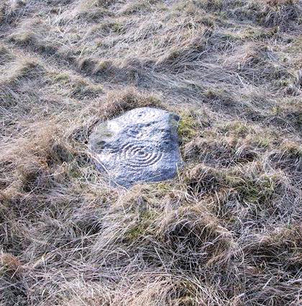
Baildon Moor carving 126
This was one of the very first examples of “cup and ring stones” that I ever saw, when I was a mere 10 or 11 years old! I’m not quite sure what I expected to find, but something about this stone with its deeply set cup-markings obviously had an effect on me – as I’m still foraging about looking at them more than 35 years later! About 20 yards away from the Glovershaw quarry carving (Baildon Moor 122), this central design stone — as I used to call it — was first recorded in W. Paley Baildon’s (1913) magnum opus and was then all-but-forgotten until the Bradford Archaeology Group mentioned it again more than forty years later. Although you can only see three distinct cups on this small rock, another 2 or 3 seem in evidence under better lighting conditions, and a small line runs below the cups in the photo here, which you can just make out above the central cup.
This carving and others close by give the distinct impression that they were once part of some seemingly lost cairn-field, awaiting rediscovery…
References:
Baildon, W. Paley, Baildon and the Baildons – parts 1-15, Adelphi: London 1913-1926.
Bennett, Paul, Of Cups and Rings and Things, unpublished: Shipley 1981.
Bennett, Paul, Megalithic Ramblings between Ilkley and Baildon, unpublished: Shipley 1982.
Boughey, Keith & Vickerman, E.A., Prehistoric Rock Art of the West Riding, WYAS: Leeds 2003.
Cowling, Eric T., Rombald’s Way, William Walker: Otley 1946.
Hedges, John, The Carved Rocks on Rombald’s Moor, WYMCC: Wakefield 1986.
Various ways here. From Keighley, go up the Halifax Road, first left after the Ingrow West train station, uphill, then up the long zizaggy road till you hit the pub at the crossroads. Park up and walk along the road in front of the pub for 1-200 yards and look at the hill above you! Alternatively, from Bingley go up to Harden on the B6429 and literally just where the village ends, there’s a small right-turn (if you’re going past the fields on either side, you’ve just missed the turning!). Go up there till the road reaches the top and stop! Catstones Hill is in the heather over the wall on your left!
Archaeology & History
A somewhat anomalous earthwork site, with lots of archaeohistorical speculation behind it, but no firm conclusion as to its precise nature as yet. Defined variously as an earthwork, an enclosure (for both people and cattle!) and a settlement by respective archaeologists over the years, there is little to be seen of the place on the ground and it doesn’t tend to bring raptures of delight to the common antiquarian. When William Keighley (1858) described this place, Catstones Ring was,
“enclosed on three sides by a considerable bank of earth, and bears evident marks of the plough. The country people believe it to have been an intrenchment or camp.”
Mrs Ella Armitage (1905) thought this site may have been “a prehistoric fort,” but said little more about it. In the same year however, Mr Butler Wood (1905) gave us a much better account of the place, describing Catstones Ring as “the most striking earthwork in the neighbourhood of Bradford.” His broader description told that:
“It encloses the crest and slope of a hill, and measures 266 yards on the east side (which is perfect), and 100 yards on the north side; the latter, however, being traceable at least 100 yards further across cultivated fields. The south side is almost obliterated by quarries, while the western portion has disappeared altogether. The fosse which surrounded this fine fortification is still visible on the eastern side.”
A couple of years later two short notes were made of the site in Forshaw’s Yorkshire Notes and Queries. Peter Craik (1907) of Keighley described the dimensions of the main ring as being “110 x 320 yards (rough guess),” and he also described finding the remains of a cairn in the outer dyke section (marked as ‘X’ on Craik’s diagram, below). On the nature of the site, he wrote:
“Catstones would appear to have been built as a defence against invasion from the south, for in contrast to the early defensible approach from that direction is the fact that to the north lies the undulating expanse of Harden Moor, which for the most part is on a level with the ring, even the highest point in the immediate vicinity being without the main circle, though enclosed in a minor outwork. The large extent of the ring makes it rather difficult to believe that enough men could be collected in the immediate neighbourhood to man the lines satisfactorily; and again as a shelter for cattle, etc, in time of war it does not appear to be well designed, for most of the interior would be commanded within easy range of arrows. Certain old excavations exist within the ring; probably they were made in search of gravel or some such material, but is this conjecture certain? Can they possibly mark the site of dwellings?”
J.J. Brigg (1907) followed up Craik’s short piece with the suggestion that the site was Roman in origin, saying:
“In showing the 6in map to Professor Bosanquet of Liverpool…he said there was no reason why it should not be Roman, merely because there is no masonry. The Roman legions went into laager* every night, and it is quite possible that some very large body of soldiers halting there for the night might have thrown up an earthwork and planted thereon the stakes which they always carried with them for that purpose.”
But I think this is most unlikely. Very little has been found here to give us a better idea of dates and function; and in a limited excavation here in 1962, no artifacts of any kind were located. A little more recently, J.J. Keighley (1981) has suggested the site to be Iron Age in date, describing it as one of the most impressive sites of its kind in the region. The Catstones Ring is “a 6.5 hectare quadrangular ditched enclosure,” he wrote, which he thought had been much destroyed by the adjacent quarrying.
“Aerial photographs taken by the County Archaeology Unit in 1977 however, shows that the southeastern corner of the enclosure and parts of its southern ditch survived the quarrying. Villy (1921) observed an outwork to the north of the main enclosure, which was visible on aerial photographs taken in 1948, and the 1977 aerial photographs…show a possible annexe attached to the outside of the northeastern corner of the main enclosure.”
P. Craik’s 1907 drawing
This extended section of Catstones’ main earthworks were, in fact, first described in the article by Peter Craik (1907), as shown in the hand-drawn plan of the site here. And in all honesty, virtually nowt’s been done since these early antiquarians diggings and essays. The information from the present day Sites and Monuments Record says that the site is a “late prehistoric enclosed settlement” and that quarrying has destroyed much of the west side.
Folklore
Harry Speight (1892) reported the earthworks here to have been a site where a great battle once took place, between the local people and the early Scottish tribes.
References:
Armitage, E., ‘The Non-Sepulchral Earthworks of Yorkshire,’ in Bradford Antiquary, New Series 2, 1905.
Best approached from the south, up Hardings Lane, then where its bends and the track of Parks Lane goes onto the moor, follow it. Onto the moor, keep on the track as it follows the walling until you reach the gate on your right. From here you’re close: head into the grasses and heather (left) not far off the western edge of the footpath at the eastern end of Dryas Dike. Look around!
Archaeology & History
This lovely looking carving “quite near to the footpath and enclosed fields above March Ghyll reservoir,” was first described by Stuart Feather. (1965) It can be found on a small flat stone and is easily obscured if the grasses are long – but it’s worth searching for. It’s an archetypal cup-and-ring stone, consisting of a cup-and-five rings, a cup-and-ring, and a cup-and-three rings — though they are rather faint and can be missed in bad light. As with other carvings, it’s best to splash water over it (as me & Richard did in the photo above) so you can see it a bit clearer. Feather (1965) told us:
“The symbols are very fine, consisting of three cup-and-rings. One of them, a quadruple, concentrically-circled cup with part of a fifth, unfinished ring. The cup is very shallow, 1 inch across, and the circles…½ inch wide and shallow, with an overall diameter of 8 inch for the four circles; 9 inch with the other unfinished section. The single cup-and-ring has a cup ¾-inch in diameter, ½-inch deep and a 4-inch diameter ring somewhat broader than the other rings on the rock and abutting on the north side against a slightly raised part of the rock surface.”
The triple-ringed cup is of similar dimensions to the larger example, with the cup being 1½ inch across and deep, with the circles being 7 to 7½-inch across.
About a half-mile northeast of here is the old Langbar Stone where I got the distinct impression that the same person was responsible for both of these carvings. God knows why!
References:
Boughey, Keith & Vickerman, E.A., Prehistoric Rock Art of the West Riding, WYAS 2003.
Feather, Stuart, ‘Mid-Wharfedale Cup-and-Ring Markings: No.32-3, Middleton Moor,’ in the Cartwright Hall Archaeology group Bulletin, February 1965.
Holy Well (destroyed): OS Grid Reference – SE 15942 34208
Also Known as:
Ash Well
Holy Well Ash Well
Pin Well
Archaeology & History
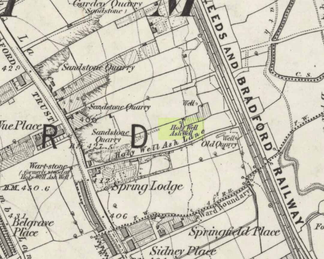
Holy Well Ash on 1852 map
Either right next to, or perhaps now beneath Bradford City’s Valley Parade football ground, was once a very important sacred well site. Known as the Holy Ash Well and variants thereof, this healing spring was of considerable renown to people all around Bradford district in bygone days. The site was illustrated on the 1852 OS map, and there was also a sacred stone adjacent to the well known as the Wart or Pin Stone, which had some animistic healing properties related the waters.
The old well was described by local historian Abraham Holroyd (1873) who said that:
“In Manningham Lane there is a fine well, in old deeds called Hellywell, i.e., holy well, in a field now called Halliwell Ash, now a stone quarry… Near this is the ancient Pin Stone.”
A few years later, in Robert Charles Hope’s (1893) monumental study, he described how,
“This holy well, not far from Manningham Lane, probably derived its name from having at some time been dedicated to some saint. The inhabitants of Bradford were wont in ancient times to resort on Sundays to these wells as a common place of meeting, to drink of the waters and partake of their preternatural virtues.”
Which was another was of saying that he didn’t really know too much about the place!
The Bradford historian William Preston (1933) described this site in one of his early essays, where he informed us that local people knew the accompanying rock hereby as the Ash Stone, due to its proximity and ritual relationship to a great old ash tree (Fraxinus excelsior) that grew next to the well. The mythic history of this particular tree should not be understated: it was a Creation deity par excellence in northern and Viking myths, but whatever old tales and power might once have been had here, in Bradford, they’ve long since been forgotten. But it was the industrial historian William Cudworth (1896) who told the most of this all-but forgotten site, saying:
“On the sloping ground between Belle Vue and the Midland Railway there once existed a spring of water, supposed to have preternatural virtues. The name it bore within present recollection is probably a corruption of Holy-well. The holy wells of England as elsewhere had not all the same virtues attached to them. Some were blessed if used for baptisms, to others were attributed curative properties, especially for sore or weak eyes, while others were supposed to possess mystical powers, insomuch as any article dipped in them became charms or safeguards against witchery. Any traditions associated with the spring at Halliwell (or Holywell) Ash are lost, but certainly in the early part of the present century the place was a favourite resort of the townspeople on Sundays.
“The derivation of the name is doubtful. In the survey of 1638 a close called ” Helliwell Ash” is mentioned as containing 2a. 3r. 26p., but without any indication as to its locality. The spelling of the name is of little moment. Mr. James, in his “History of Bradford,” states that he had seen the place referred to in old deeds as “Helly-well.” By his will, dated May, 1685, Thomas Lister, of Manningham, devised to his two daughters, Juliana Lambrecht and Elizabeth Stapleton, equal shares in two closes of land called “Holywell Ash” and ” Delf Close,” besides other lands in Manningham. In the will disposing of the possessions of Juliana Lambrecht, her moiety of “Holywell Esh” was bequeathed to Francis Stapleton, her nephew. In due course the lands in question were inherited by Francis Sharp Bridges, and have latterly belonged to Sir Francis Sharp Powell, M.P., in whose writings the form of spelling is given as ” Halliwell Ash.”
“Upon the ground in question there used to be a fine well of water issuing out of the higher ground, to which tradition assigned healing virtues. Might not the name of “holy” come from this circumstance? Sufficient importance attaches to the tradition, however, to have led the farmers of the recent ordnance plan of Manningham to preserve the name, although the widening of the Midland Railway below Thorncliffe Terrace has almost obliterated the site.”
A more recent updated overview of the site was written by one of my old school-mates, Dave Pendleton (1997), who said of the place:
“Prior to 1886 the only feature of any real note in the Valley Parade environs was a holy well that emerged near the corner of the football grounds Midland Road and Bradford End stands; hence the road Holywell Ash Lane. Today the site of the well is covered by the football pitch.
Only the road name survives as a reminder of what was apparently one of the district’s foremost attractions. On Sundays and holidays people would gather to take the waters and leave pins, coins, rags and food as offerings to the spirit that resided in the waters.
Accounts suggest that the well was covered and had a great ash tree standing over it (hence ‘holy ash’). There was also a standing stone called the wart stone of unknown antiquity. The stone had a carved depression that collected water. It was believed that the water was a miraculous cure for warts. Indeed, as early as 1638 the Holy Well had been credited with healing powers.
The well suffered a decline in popularity during the late nineteenth century and its keepers resorted to importing sulphur water from Harrogate, which they sold for a half penny per cup. The well disappeared under the Valley Parade pitch during the summer of 1886 and the wart stone was moved to the top of Holywell Ash Lane – which then ran straight up to Manningham Lane. The stone was still there as late as 1911 but thereafter it seems to have disappeared into the mists of time.”
A night-club adjacent to the Valley Parade football ground—called Bibby’s—was said to have had an old well in its cellar, which the owner of the place, Mr Pearl Gladstone Minott, said was ‘haunted’.
Unfortunately I’ve not been able to find any old photos or drawings of this lost holy well – though I imagine that some local, somewhere must be able to help us out with this one. Surely there’s more of this site hidden away somewhere….?
References:
Bennett, Paul, The Old Stones of Elmet, Capall Bann: Milverton 2001.
Cudworth, William, Manningham, Heaton and Allerton, W. Cudworth: Bradford 1896.
Legendary Tree (destroyed): OS Grid Reference – SK 49751 83799
Folklore
This was one of the many sacred trees beneath or next to which, in pre-christian days, tribal councils met. Thanks to the local historians Paul Rowland and Lis Tigi Maguire Coyle (see ‘Comments’, below), the whereabouts of the tree has been located (contrary to my earlier idea that it had sadly died). The local writer Harry Garbutt wrote of it in the 1940s, saying:
“The importance of Harthill in Saxon days may be adduced also from the fact that of the Three Hundreds of the Wapentake, Harthill was one. The Hundred was the Court of local justice and government, and at Harthill would meet under the old Trysting Tree.”
The very word trysting relates to any species of tree that has importance, be it by its appearance or position, and relates to those that were used as traditional or popular meeting sites.
References:
Garbett, Harry, The History of Harthill-with-Woodall and its HamletKivetonPark, Arthur H. Stockwell: Ilfracombe n.d. (c.1948)
Acknowledgements: Massive thanks to Paul Rowland (‘Comments’, below), for information pointing us to the exact spot where our Trysting Tree lived; and to Lis Tigi Maguire Coyle for the additional folklore ‘Comment’, below. Huge thanks to you both!
The easiest way to get here if you’re coming for the first time is via the A6068 Glusburn to Cowling road. On the south side of Cowling, take the small road Old Lane, uphill on the east side of the road (very easily missed – keep your eyes peeled!) and keep going up until the road just about levels out, where there’s a muddy parking spot on your left (the giant Wainman’s pinnacle is down the path from here). Cross over the road and head up towards the giant Hitching Stone. When you reach the first fence, cross over it and follow it into the boggy heathlands to your right (west-ish). Head into the tribbly grass and keep walking for 3-400 yards till you see the large rock growing out of the Earth.
Archaeology & History
Cup-markings near ground-levelLooking from above
Not far from the legendary Hitching Stone is this curiously-shaped boulder sitting peacefully and alone in its landscape. It is in fact a large cup-marked boulder, previously unrecorded until being described in The Old Stones of Elmet. On top of the stone it seems that there are no definite man-made cup-markings, but there are a number of seemingly natural ones (although some could have been etched thousands of years ago and have just eroded well); instead the real cup-markings are found curiously etched at the base of this large rock, just above ground-level.
Hitching Stone on horizon
As can be seen in the photos, on its lower south-facing edge there are around 20 well-defined cups that clearly stand out. No other cup-marked stones appear to be nearby (surely there’s a few more kicking about in the area…?).
An earlier assertion I made (2001) about the nearby Hitching Stone aligning with the winter solstice sunrise from here was recently put to bed following the morning observations of myself and Dave Hazell on December 21st, 2010, when — as can be seen in the photo here — the midwinter sun emerges from the land a few degrees of arc further southeast than expected. However, I aint checked what the alignment here would have been when the cup-markings were first etched here, around 5000 years ago perhaps… Would any of you archaeo-astronomers out there know about this?
Follow the same directions to reach the Big Rock carving. From here walk less than 100 yards up the slope, veering to your left and where you reach the rushes (Juncus grasses), walk up and keep your eyes peeled for the singular upright rock. Or as ‘Redkiteyorks’ said, go “up the slope 82.4 metres, 54.5 degrees(True) from IAG108 (Big Rock).” It aint hard to find really…
Archaeology & History
Another stone mainly for the purists amongst you. Little has been written on this possible carving. Boughey & Vickerman (2003) said simply:
“Large rough rock. Two possible cups on top and one further possible cup on W vertical face. Doubtful”.
References:
Boughey, K.J.S. & Vickerman, E.A., Prehistoric Rock Art of the West Riding, WYAS: Leeds 2003.
Hedges, John (ed.), The Carved Rocks of Rombald’s Moor, WYMCC: Wakefield 1986.
From the little hamlet of Langbar, head up to the steep footpath to Beamsley Beacon and from there along the footpath get yourself between the giant cairn known as The Old Pike and Round Hill. About halfway between these two points the moor levels out (with brilliant views in all directions) and 200 yards southeast of the upright boundary stone, this well-defined carved rock is just a few yards north off the footpath. It seems to be just over the boundary line of Middleton Moor and onto the Beamsley Moor side (not that you give a shit when you’re up here ambling about – but the cartographers like to get things right I s’ppose!).
Archaeology & History
…and from another angleSketch of the design
Near the very top of the moor this one — this is a small carving that I rediscovered in March 2005, much of it covered in peat and heather. It’s very similar to some of the central designs found on the Baildon Moor cup-and-ring carvings, with four cup-markings (3 are deep) in a slight arc to the southern edge of this small, squared stone, very much like carvings 126 and 130 in the Boughey & Vickerman (2003) survey. However, unlike the Baildon Moor examples, no burials seem to accompany this carving—although the surrounding heather may be hiding other archaeological remains.
References:
Boughey, Keith & Vickerman, E.A., Prehistoric Rock Art of the West Riding, WYAS 2003.
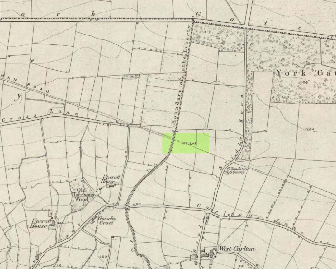
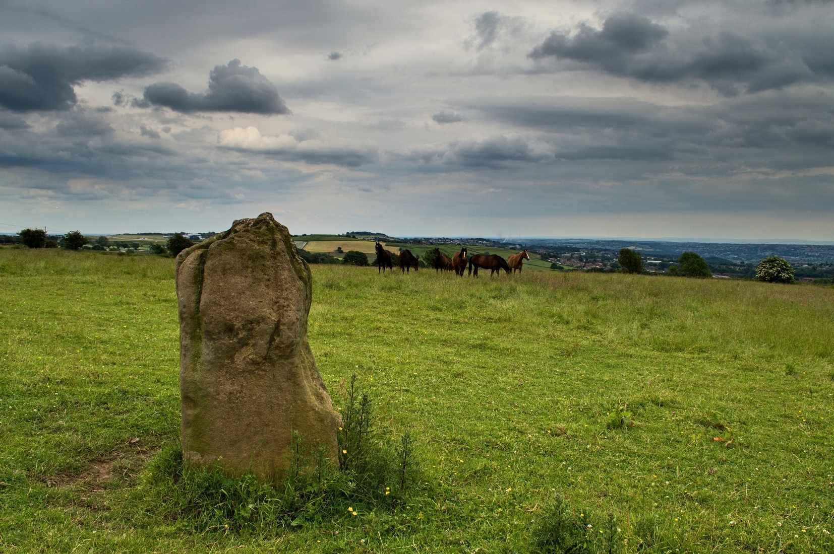
Worth checking this if you aint seen it before! Head up to the back (south-side) of Otley Chevin (where the cup-and-ring Knotties Stone lies sleeping), following the road there and park up near/at the Royalty pub. Take the footpath behind the pub which crosses the fields and once into the second field, head diagonally down to the far-left corner. From here, look over the wall — you can’t really miss it!
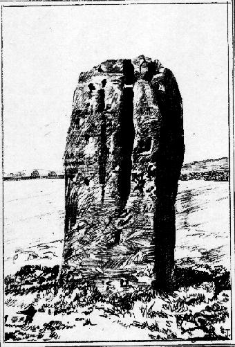
Archaeology & History
An intriguing site for various reasons. All we have left to see of any value nowadays is this nigh-on 6-foot tall thick monolith, standing alone in the field halfway between West Carlton and Otley Chevin. Completely missed in local archaeological surveys, the place was mentioned briefly by Slater (1880); though it appears to have been first described in detail by Eric Cowling (1946), who suspected the stone may have Roman origins (though didn’t seem too convinced!), saying that:
“near the ground the section is almost oblong, with sides three-feet six-inches by one-foot ten-inches; two feet from top, the section is almost circular.”
The fact that the stone stands very close to the line of an all-but forgotten Roman road that runs right past it added weight to this thought (the road runs towards a Roman settlement a mile east of here near Yeadon). But this standing stone is unlikely to be Roman. More recent evidence seems to indicate a relationship with a now-lost giant cairn about 100 yards to the south. The only remains we have of this place are scatterings of many small loose stones nearby. And it seems a very distinct possibility that the extra standing stones that were once hereby, stood in a line.
The very first reference I’ve found about this site also indicates that there was more than one stone here in the past! In 1720 this site was known as the ‘Boon Stones’; and the plural was still being used by the time the 1840 Tithe Awards called them the ‘Boul Stones.’ Initially it was thought that both words were plural for “bulls” — as A.H. Smith (1962) propounds in his otherwise superb survey — but this is questionable. (see Folklore)
Folklore
A piece of folklore that seems to have been described first by Philemon Slater (1880) relates to the pastime of bull-baiting here, that is –
“fastening bulls to it when they were baited by dogs, a custom…still known to the Carlton farmers” (North Yorkshire).
Cowling (1946) told that he heard the stone was said to be lucky as well as being a source of fertility. This ‘fertility’ motif may relate to the meaning of the stone’s early name, the Boon Stones. Both boon and boul are all-but obsolete northern dialect words. ‘Boul’ is interesting in its association with a prominent folklore character, as it was used as a contemptuous term “for an old man.” Now whether we can relate this boul to the notion of the ‘Old Man’ in British folklore, i.e., the devil, or satan — as with the lost standing stone of The Old Man of Snowden, north of Otley — is difficult to say.
More interestingly perhaps is the word ‘boon’, as it is an old dialect word for “a band of reapers, shearers, or turf-cutters.” This band of reapers ordinarily consisted of five or six people and would collect the harvest at old harvest times. And as the early description talks of Boon Stones, this plurality would make sense. One curious, though not unsurprising folklore relic relating to these boons was described at another megalithic site (now gone) by John Brand (1908), where in the parish of Mousewald in Dumfries,
“The inhabitants can now laugh at the superstition and credulity of their ancestors, who, it is said, could swallow down the absurd nonsense of ‘a boon of shearers,’ i.e., reapers being turned into large grey stones on account of their kemping, i.e., striving.”
Standing stones with the folklore of them being men or women turned to stone is common all over the world. If we accept the dialect word ‘boon’ as the first name of this old stone, there may once have been some harvest-time events occurred here long ago (and this is quite likely). Equally however, we must also take on the possibility that this Bull Stone has always been a loner and that its name came from the now obsolete Yorkshire word, a bull-steann, meaning a stone used for sharpening tools, or a whetstone.
Take your pick!
References:
Bennett, Paul, The Old Stones of Elmet, Capall Bann: Milverton 2001.
Brand, John, Observations on the Popular Antiquities of Great Britain – volume 2, George Bell: London 1908.
Cowling, Eric T., Rombald’s Way, William Walker: Otley 1946.
Jackson, Sidney, ‘The Bull Stone,’ in Cartwright Hall Archaeology Group Bulletin, 2:5, 1956.
Smith, A.H., English Place-Name Elements – 2 volumes, Cambridge University Press 1956.
Smith, A.H., The Place-Names of the West Riding of Yorkshire – volume 7, Cambridge University Press 1962.
Slater, Philemon, The History of the Ancient Parish of Guiseley, William Walker: Otley 1880.
Go up through Baildon centre and head onto the moors. Crossing the cattle-grid, a coupla hundred yards further up, turn left. Past the small reservoirs on your left, another 100 yards or so and you reach the brow of the hill. As you begin going down the road, there’s a small car-park right by the roadside. The curious remains of the earthworks at the side of the old circle are discernible in the grassland right to its side.
Archaeology & History
Illustrated on the 6-inch OS-map of 1852 as “Site of a Barrow” (similar to how it appears in the image drawn here by Mr. C.N.M. Colls) a short distance below Pennythorn Hill top, there are still considerable traces of the earthworks surrounding the east and southern sides of what was once some form of ring cairn or tumulus that was once at this prominent place in the landscape.
Aerial view of siteThe site was first explored by Mr Colls in 1843 (his results were reported a few years later), who found a loose double-ring of stones, fifty feet across, surrounded by a shallow trench which was most notable on the south and east sides. Two urns were also uncovered near the centre of the ring, nearly two feet down, containing the cremated remains of people. A few years later, the Leeds historian James Wardell (1869) told a most fascinating note about what happened during their excavation, saying:
“This…examination was attended by a circumstance not soon to be forgotten by the persons engaged therein (on the excavation). They had almost reached the place where the broken urn and bones were deposited when, at once, such a fearful storm of thunder, lightning and rain came on, that they were not only considerably alarmed, but driven from the Common to seek shelter in the village.”
Colls’ 1846 sketch
We hear this sorta thing at many of our ancient places!
Colls 1846 plan
One anonymous writer in 1955 described the site as a ‘stone circle’, and a number of subsequent archaeologists copied this without question; but in all probability this site was more typical of an old cairn circle or ring-cairn, similar in size and design to the Roms Law circle two miles north of here. However, the earthworks at its side give the impression of some sort of exaggerated hengiform enclosure.
The place-name element howe strongly indicates a burial site and is a suffix found at many prehistoric tombs across northern England. The prefix ‘acre’ may relate to “a plot of arable or cultivated land, a measure of land (an acre) which a yoke of oxen could plough in a day” (Smith 1956), or may be a corrupted form of the Old English word, ‘acen’, relating to oak trees. Early literary examples of the place-name would enable a clearer understanding of the prefix element here.
References:
Anonymous, Colls’ Burial Mound Stone Circle, Baildon Moor, Museum Leaflets: Bradford 1955.
Baildon, W. Paley, Baildon and the Baildons (parts 1-15), St. Catherines: Adelphi 1913-26.
Barnes, Bernard, Man and the Changing Landscape, Eaton: Merseyside 1982.
Bennett, Paul, The Old Stones of Elmet, Capall Bann: Milverton 2001.
Colls, J.N.M., ‘Letter upon some Early Remains Discovered in Yorkshire,’ in Archaeologia, 31, 1846.
Collyer, Robert & Turner, J.H., Ilkley: Ancient and Modern, William Walker: Otley 1885.
Smith, A.H., English Place-Name Elements – volume 1, Cambridge University Press 1956.
Wardell, James, Historical Notes of Ilkley, Rombald’s Moor, Baildon Common, and other Matters of the British and Roman Periods, Joseph Dodgson: Leeds 1869. (2nd edition 1881)


")