Castlestead Ring, Cullingworth, West Yorkshire

Enclosure:  OS Grid References – SE 0514 3627

Also Known as:

  1. Blood Dykes

Getting Here

The complete Castlestead Ring on 1852 map

Dead easy this one!  On the Keighley-Halifax A629 road, about 500 yards south past Flappit Spring (public house), there’s a small road to your right.  Walk on here for 200 yards and look in the field to your right.  If the grass is long you might struggle to see it, but gerrin the field and it runs right up against the wall.  Y’ can’t miss it really!  You can park up a coupla hundred yards down the A629 main road, by the old quarry, and walk back to get here.

Archaeology & History

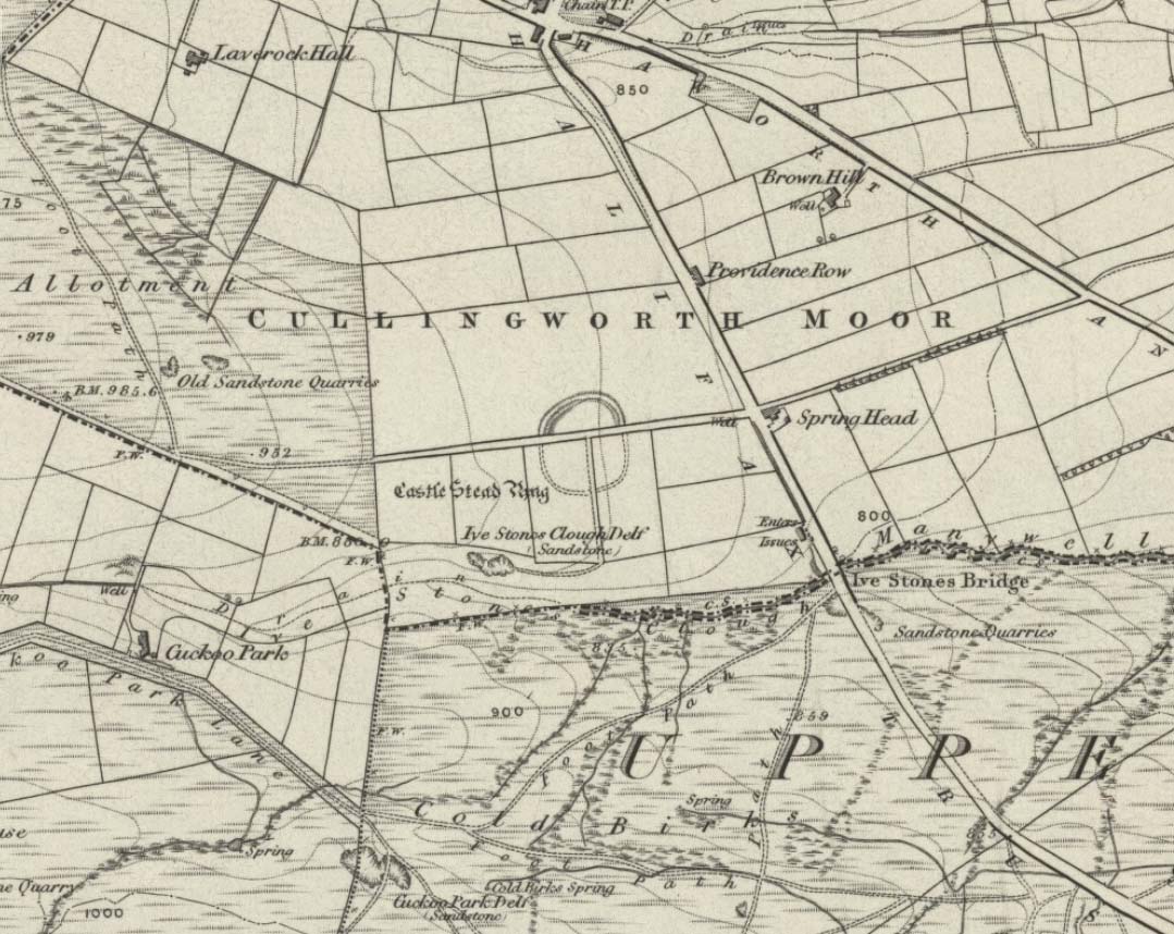
Although I’ve earlier described this as “nowt much to look at,” the more I come here, the more I like the place (sad aren’t !!?).  The hard-core  archaeology folks amidst you should like it aswell.  Not to be confused with the site of the same name a mile to the south of here, this large earthwork was shown on the 1852 OS-map as a complete ring, which is also confirmed in old folklore; and a survey done by Bradford University in the late 1970s indicated a complete circle was once in evidence.  To view this for yourself: if you type the OS grid-reference into Google maps, you’ll see from the aerial image that a complete ring was indeed here at sometime in the not-too-distant past.

Bend in the ditch on northern side of the ring
Harry Speight’s 1898 drawing

Today however – indeed, since William Keighley described it 1858 – there’s only a shallow, semi-circular ditch to be seen in the fields.  But despite this, its remains have brought it to the literary attention of about a dozen writers – though we still don’t know exactly what it was!  The best conjecture is by the archaeologist Bernard Barnes (1982), who thinks it best to describe as a enclosure or earthwork dating from the Bronze Age.  Eighty feet across and covering more than 1.5 acres, an excavation of the site in 1911 found nothing to explain its status.

One of the first descriptions of this site comes from the pen of the industrial Bradford historian, John James in 1876 (though Hearne, Leland and Richardson describe it in brief much earlier). Talking of the sparsity of prehistoric remains in the region (ancient history wasn’t his forte!), he said, “I know of no British remains in the parish that are not equivocal, unless a small earth-work lying to the westward of Cullingworth may be considered of that class.”

Indeed it is! He continued:

“It is situated on a gentle slope, about two hundred yards from a place called Flappit Springs, on the right-hand side of the road leading thence to Halifax. The form has been circular. (my italics) The greater part of it to the south has been destroyed by the plough. I took several measurements of that part which remains, but have mislaid the memoranda I then made; I however estimate the diameter to have been about 50 yards. The ditch to the westward is very perfect. It is about two yards deep and three wide; with the earth thrown up in the form of a rampart on the inner side. The remain is less perfect to the eastward.”

James then speculates on the nature of the site, thinking it to be “one of a line of forts erected by the Brigantes…to prevent the inroads of the Sistuntii.” Intriguing idea!

A few years later when William Cudworth (1876) visited the site, he described:

“At present there only remains about one-fourth part of a circle representing the appearance of a considerable earthwork or rampart. The remainder has been cut away by the construction of the road leading to the allotments.”

Echoing Mr James’ sentiments, Cudworth also suggested “it may have been an enclosure to guard their cattle, while in summer they grazed on the vast slope on which it stands.”  Y’ never know…

NW section showing bank and ditch
Exposed stonework of inner embankment

A visit to the place on October 21 2007, found not only a profusion of mushrooms scattering the field (varying species of Amanita, Lycoperdon, Panaeolina, Psilocybes, etc), and the remnants of two old stone buildings 20 yards of the NE side, but a distinctive ‘entrance’ on the northern side of the ring, which gave the slight impression of it being a possible henge monument. It’s certainly big enough! All traces of the southern-side of the ring however, have been ploughed out.

The views from here are quite excellent, nearly all the way round. You’re knocking-on a 1000 feet above sea level and the high hills of Baildon, Ilkley, Ogden Moor and the Oxenhope windmills are your mark-points. There’s one odd thing to think about aswell: if this is a prehistoric site, it’s pretty much an isolated one according to the archaeo-catalogue – and as we know only too well, that aint the rule of things. We’ve got adjacent moorlands south and west of here, very close by. Likelihood is, there’s undiscovered stuff to be foraged for hereabouts…

Folklore

An old folk-name given to this ring is the Blood Dykes, which is supposed to relate to the place being the site of a great battle.

References:

  1. Barnes, Bernard, Man and the Changing Landscape, Eaton: Merseyside 1982.
  2. Bennett, Paul, The Old Stones of Elmet, Capall Bann: Milverton 2001.
  3. Cudworth, William, Round about Bradford, Thomas Brear: Bradford 1876.
  4. Elgee, Frank & Harriett, The Archaeology of Yorkshire, Methuen: London 1933.
  5. Forshaw, C.F., ‘Castlestead, near Cullingworth,’ in Yorkshire Notes and Queries – volume 4, H.C. Derwent: Bradford 1908.
  6. James, John, The History and Topography of Bradford, Longmans: London 1876.
  7. Keighley, J.J., ‘The Prehistoric Period,’ in Faull & Moorhouse’s, West Yorkshire: An Archaeological Survey to AD 1500 – volume 1, WYMCC: Wakefield 1981.
  8. Keighley, William, Keighley, Past and Present, Arthur Hall: Keighley 1858.
  9. Speight, Harry, Chronicles and Stories of Bingley and District, Elliott Stock: London 1898.

© Paul Bennett, The Northern Antiquarian


Low Snaygill Stone, Skipton, North Yorkshire

Cup-and-Ring Stone:  OS Grid Reference – SD 9940 4973

Also Known as:

  1. Carving SK1 (Hedges)
  2. Carving no.16 (Boughey & Vickerman)
  3. Snaygill Farm Stone

Getting Here

Stone by the roadside

Not too far from the High Laithe cup-and-ring stone.  Along the A6131 out of Skipton, park up at the Rendezvous hotel and go up the road on your left, over the canal.  As you approach the second house up, note the rock on the right-hand side of the tiny road, perched on the edge above the stream, with ivy creeping up one side of it.  That’s it!

Archaeology & History

This stone was moved to its present position a few decades back, sometime before Hedges (1986) first recorded it in his Carved Rocks work.  It’s a reasonably large boulder, resting on the slope above the drop to the stream below, and will probably drop into the waters in the not-too-distant future.  Whether the stream had any initial relationship with the cup-markings etched on its surface, we’ll probably never know (a number of rock art students love the water-stone relationship — and this one is no doubt in their listings!).  Its first literary appearance by Hedges described it thus:

“Large fairly smooth grit rock sloping down to stream at E and into ground and grass at W.  Eleven cups, circle of nine very small cups at one end, groove from depression, one other groove and possible cup.”

Lower half of CR-016

Which just about does it justice.  When we visited the place yesterday, the cluster of small cups at the top of the rock were difficult to see clearly in the grey daylight; but what seems to be another 2 cups (not in Hedges, nor Boughey & Vickerman’s [1986] survey) may be on the lower-half of the stone, and can be seen in the photo here.  We need to go back again on a bright day and catch the stone in a different mood to suss out whether we were just seeing things.

References:

  1. Boughey, Keith & Vickerman, E.A., Prehistoric Rock Art of the West Riding, WYAS: Leeds 2003.
  2. Hedges, John (ed.), The Carved Rocks on Rombald’s Moor, WYMCC: Wakefield 1986.

© Paul Bennett, The Northern Antiquarian


High Laithe Stone, Skipton, North Yorkshire

Cup-and-Ring Stone:  OS Grid Reference – SD 9952 4991

Also Known as:

  1. Carving SK2 (Hedges)
  2. Carving no.17 (Boughey & Vickerman)

Getting Here

High Laithe cup-and-ring stone

Worth the short trek if you like your cup&rings!  On the Aire Valley Keighley-to-Skipton road (A629), as you approach the southern outskirts of Skipton, take the turning at the roundabout as if you’re going into the town up the A6131. Go over the next roundabout a coupla hundred yards on, then 200 yards further on note the right-turn up over the canal (big hotel just here, where you could park up).  Walk over the canal up the tiny country lane. Ignore the first left turn and walk up, bearing next left uphill and onto the footpath. Walk up the hillocky quarried bit until you reach the stile in the wall.  Once on the other side, look in the walling 20 yards uphill.  You can’t miss it!

Archaeology & History

First described by Messrs Hartley and Radley in the Yorkshire Archaeological Register of 1968, this small “standing stone”, less than three-feet tall, has a distinct cup-and-double- ring carved onto its upright north-facing edge.  The outline of the carving is visible even in bad light, though you might wanna rest and gaze for a minute or two for yourself and the lighting to adjust if it’s a grey day.  There’s another cup-marking below the bottom right of the double-ring, with another ‘possible’ just above ground-level.

References:

  1. Boughey, Keith & Vickerman, E.A., Prehistoric Rock Art of the West Riding, WYAS: Leeds 2003.
  2. Hedges, John (ed.), The Carved Rocks on Rombald’s Moor, WYMCC: Wakefield 1986.

© Paul Bennett, The Northern Antiquarian


Clach na Sithean, Strathtay, Perthshire

Cup-Marked Stone:  OS Grid Reference – NN 895 531

Also Known as:

  1. Balendune
  2. Ballinduin

Folklore

This large cup-marked stone was known by local people as the Clach na Sithean, or the stone of the fairies.  Its smooth surface and well-cut grooves was said to be due to the fairies sharpening their knives upon it, and the straight cuts or grooves were tests of the keenness of their blades.

In addition to the fairies having hold over this stone, a brownie creature also roamed between here and the burn of Allt Mor.  Although a dutiful creature, he commonly used to scare the women when they returned from the ceilidhs by chasing them and screaming a curious noise at them. But as well as this, he would also enter the local houses and farms after nightfall and, when the local folk were asleep, would clean the supper dishes and put them in their rightful places. But if there was no work to be done once he had entered their homes, he would take the dishes out and place them on the floors where they would be found in the morning by perplexed householders.  Then they’d know that the brownie had visited. Sometimes he was a great help to the housewives, other times a nuisance.  He became known to local people as Puddlefoot, or Cas an Lubain, but so offended was he by the name when he heard it, that he let out an almighty scream and vanished, never to be seen again.

References:

  1. Kennedy, James, Folklore and Reminiscences of Strathtay and Grandtully, Munro Press: Perth 1927.

© Paul Bennett, The Northern Antiquarian


The Bodach and Cailleach, Gigha, Argyll

Sacred Stones:  OS Grid Reference – NR 6382 4730

Folklore

The Bodach and the Cailleach
The Bodach & the Cailleach

On this “Isle of the Gods” — as some historians proclaim Gigha to mean — the ancient rites and ceremonies of local folk continued until pretty recent times.  One writer narrated some intriguing pre-christian events connected to this curious and little-known place, speaking of indigenous heathen rites:

“These are in fact known to have persisted on the island until well into the early part of the (19th) century when Irish fishermen could still be seen climbing the little hill of Moinean Sitheil, in the sacred Moss of Peace below Ardminish, to pay homage to the “Old Ones” of Gigha: a pair of ancient legend-shrouded stones known as the Bodach and the Cailleach, that from time immemorial have stood upon a low green knoll below the farm of Achamore.

“Through the countless ages the strange jug-headed little Bodach and his smaller consort have kept steadfast vigil over Gigha: their mysterious aura said to guarantee its continuing fertility and prosperity as they link the thriving island of today with beliefs and traditions having roots in the earth-cults and sun-worship of primeval times.  In the past folk would have honoured them with offerings of meal or milk and even now they still command considerable local affectation and respect, albeit expressed in less overtly pagan ways.  And so they stand as ever upon their tiny hillock gazing out across tumbling terraces of old Cantereoch and beautiful Ardlamey Bay, inscrutable and silent, yet with a strangely ‘knowing’ air impossible to define.”

References:

  1. Anonymous, Exploring Historic Kintyre and the Isle of Gigha, Harlequin Press: Oban n.d.

© Paul Bennett, The Northern Antiquarian


Glovershaw Quarry Stone, Baildon Moor, West Yorkshire

Cup-Marked Stone:  OS Grid Reference – SE 13044 40093

Also Known as:

  1. Carving BM5 (Hedges)
  2. Carving no.122 (Boughey & Vickerman)

Getting Here

Follow the same directions as those to reach the small Central Design Stone up past the top-end of Shipley Glen.  You’ll notice the small disused quarry just a few yards away, and this partly-covered flat stone lies right at the very edge of the quarry itself.

Archaeology & History

Faint cups on CR-122
Plan of CR-122 (after Hedges)

Unless you catch this stone in good light, many of the cups on this design are difficult to make out; but defocus for a bit and they’ll come to you.  Around 13 cups have been counted on this stone, with a couple of grooves: one of which descends just by the small arc (a common local feature on Baildon’s carvings), near the eastern side of the stone.  A larger basin below this, covered by earth, may or may not be natural.  Two of the cups here may have been carved sometime in the late 19th or early 20th century, probably around the time the quarrying was being done.

As is common in some parts of Britain, this carving (and others nearby) was found in association with a small cairn-field, much of which has long since gone.

It’s very probable that there were other petroglyphs close to this one, but which have subsequently been destroyed as a result of the quarrying operations here.

References:

  1. Baildon, W. Paley, Baildon and the Baildons – parts 1-15, Adelphi: London 1913-1926.
  2. Bennett, Paul, Megalithic Ramblings between Ilkley and Baildon, private manuscript: Shipley 1982.
  3. Boughey, Keith & Vickerman, E.A., Prehistoric Rock Art of the West Riding, WYAS: Leeds 2003.
  4. Jackson, Sidney, “Cup-Marked Boulder near the Glovershaw Footpath,” in Cartwright Hall Archaeology Group Bulletin, 2:17, 1957.
  5. Hedges, John, The Carved Rocks on Rombald’s Moor, WYMCC: Wakefield 1986.

© Paul Bennett, The Northern Antiquarian


Harden Moor Stone Row, Bingley, West Yorkshire

Standing Stones (lost):  OS Grid Reference – SE 07 38

Getting Here

This site hasn’t been located. However, if it hasn’t been destroyed by the quarrying on the SW side of the moor, remains of it should still be found amidst the heather and would be a good discovery for any enthusiast.

Archaeology & History

The first notes I found about this place were those by archaeologist Sydney Jackson in 1956, who wrote:

“It would be interesting to know what Dr Richard Richardson, of Bierley Hall, Bradford meant when, writing about 1709, he said that Mr Benjamin Ferrand show him a ‘skirt of stones’ on Harden Moor, near to a row of stones placed in a line nigh two hundred paces in length some two feet above the heath, others hidden beneath it.” (my italics)

The undoubted man-made nature of this row of stones was emphasized by Dr Richardson when he wrote,

“That these stones were placed here by design, no person can doubt; but for what I end cannot conjecture, having never seen anything of this kind before.”

The great Yorkshire historian Harry Speight (1898) also came across the same antiquarian notes many years before and speculated how,

“it may be inferred from this that it had been a double row of stones, like the avenue of Maiden Castle in Swaledale.”

The ‘skirt of stones’ that were described here may be the well-preserved Harden Moor Circle.  However in recently finding the short essay of Peter Craik (1907) of Keighley, this idea may need re-assessing, as Craik clearly shows in his survey of the the nearby Catstones Ring earthwork, what he described as the “remains of a cairn” on the northern edge of that ring, giving us a different location for this lost stone row.

However, another potential position for our lost stone row that needs exploring is the one described by Butler Wood following an exploratory visit here with the Bradford historian, William E. Preston, at the beginning of the 20th century.  Mr Wood (1905) told of them both coming across some sort of earth-and-stone line “half-a-mile north of” the Catstones Ring, telling:

“Mr W.E. Preston and myself traced a short time ago on Harden Moor, remains of an entrenchment for a distance of 80 or 90 yards.  It faces south, and lies near Spring Head Heights.  The wall consisting of boulder and earth rising three feet above the soil, but there is no trace of a ditch.”

This is obviously half the length described by Richardson and Ferrand in 1709, but nearly two centuries separate the two accounts (the position of Mr Woods’ line is roughly SE 072 387; whilst that nearer to the Catstones Ring would be nearer SE 069 383).

I’ve searched the tops of this moorland a number of times hoping to locate this seemingly important megalithic stone row, obviously without success.  Further searches on the moor are needed after the heather’s been burnt back.

References:

  1. Craik, Peter, “Catstones Ring,” in C.F. Forshaw’s Yorkshire Notes & Queries, volume 3 (H.C. Derwent: Bradford 1907).
  2. Jackson, Sidney, “Harden Circle Found,” in Cartwright Hall Archaeology Group Bulletin, 2:1, July 1956.
  3. Speight, Harry, Chronicles and Stories of Old Bingley, Elliott Stock: London 1898.
  4. Wood, Butler, ‘Prehistoric Antiquities of the Bradford District,’ in Bradford Antiquary, volume 2, 1905.

© Paul Bennett, The Northern Antiquarian


Adam’s Oak, Brierley, South Yorkshire

Legendary Tree:  OS Grid Reference – SE 4280 1015

Also Known as:

  1. Adam & Eve’s Oak
  2. Wind-gap Oak

Archaeology & History

Highlighted on the 1854 Ordnance Survey map close to the township boundary line as Adam & Eve’s Oak, between Brierley and South Kirkby, I can’t find too much about this once great tree.  However the Wakefield historian W.S. Banks (1871) told us the following:

“Upon the common at Ringston Hill grows the remarkable ‘old Adam’ oak, much decreased in size in late years.  It is an ancient and large tree measuring twenty-seven feet in girth at a yard above the ground.  The trunk is hollow and the north side is broken away.  Most of the branches are also gone.  In 1868 a very large branch was blown off by the wind; but on the southerly side are still some very vigorous limbs.”

The old oak on the 1854 map

Even when Banks wrote this he said how the tree “must be many centuries old.”  In the time of King Charles II there used to be an old inn by Adam’s Oak at the foot of Ringston Hill, where the famous highwayman, Nevison (much-loved by many Yorkshire-folk because of his Robin-Hood-like character), used to stay.  The inn was owned by one Adam Hawksworth, but was ordered “to have his sign taken down for harbouring Nevison.”

Folklore

W.S. Banks also wrote of this once great tree:

“The people at Brierley tell of Nevison the highwayman lodging in it and hiding stolen treasures in it, things which probably did not happen, though Nevison’s name is connected with Ringston Hill.”

The treasure legend may have more to do with the adjacent stone circle, as we find ‘treasure’ a common motif at such places.

References:

  1. Banks, W.S., Walks in Yorkshire: Wakefield and its Neighbourhood, Longmans, Green  Co.: London 1871.

© Paul Bennett, The Northern Antiquarian 


Hawk Stone, Spelsbury, Oxfordshire

Standing Stone:  OS Grid Reference – SP 33923 23544

Getting Here

Hawk Stone on 1885 map

Best visited out of season before the corn’s been planted. It makes it  easier to find and doesn’t annoy the land-owner here, who tends to be a decent dood.  From Chipping Norton go southeast along the B2046 road to Charlbury.  After about 1½ miles take the second right turning down the small country lane.  Go slowly down here for less than half a mile, watching the fields on your right.  You’re damn close!

Archaeology & History

The Hawk Stone

This impressive, weather-worn, eight-foot tall standing stone stands aloft in the middle of a field due west of the road between Chalford Green and Dean.  It’s an excellent monolith and one which, I think, has a lot more occult history known of it than described here.  Thought by O.G.S. Crawford (1925) and others in the past to have been “formerly part of a chambered structure,”  or prehistoric chambered tomb like that of the Hoar Stone at nearby Enstone, no remains of such a structure unfortunately remain today.  It is first illustrated and named on a local map of the region in 1743 CE, and the stone at least has fortunately managed to escape the intense agricultural ravages endemic to this part of the country.

The name “Hawk” stone has been fancied by some to relate to some obscure resemblence to a Hawk, or because there very often are hawks hovering over those upland fields – but these are unlikely.  It’s thought by place-name authorities more likely to derive from a corruption of ‘Hoar’ meaning a grey or boundary stone; and as it stands just yards east of the present township boundary line, this derivation seems more probable.

To all lovers of megalithic sites, we highly recommend a visit here!

Folklore

In local folklore and in the opinion of some earlier historians, the Hawk Stone formed an integral part of a stone circle here, but there is little known evidence to substantiate this.

Hawk Stone in summer
Hawk Stone in winter

A creation legend attached to this site tells that the stone was thrown, or dragged across the land, by a old witch or hag — though we are not told from where.  This is a motif found at megalithic sites all across the country (see Bord & Bord 1977; Grinsell 1976, etc).  In Corbett’s History of Spelsbury (1962) the author told of the folklore spoken of by one Mr Caleb Lainchbury who

“said the cleft at the top of the Hawk Stone at Dean was supposed to of been made by the chains of the witches who were tied to it and burnt. As witches seem to have been extremely rare in Oxfordshire it cannot have been a very common practise to burn them at Dean; but there may indeed have been some kind of fire ceremonies near the stone.”

Grinsell (1976) also tells how the Hawk Stone has that animistic property, bestowed upon other old monoliths, of coming to life and going “down to the water to drink when it hears the clock strike 12.”

This evidently important and visually impressive monolith also plays an important part in an incredibly precise alignment (ley) running roughly east-west across the landscape.  At first, Tom Wilson (1999) thought the alignment had previously gone unnoticed, but later we later found a reference to the same line in an early copy of The Ley Hunter (Cooper 1979). It links up with other important megalithic sites, such as the Hoar Stones at Enstone, Buswell’s thicket, and the ancient Sarsden Cross.

Similarly, when Tom Graves’ (1980) was doing some dowsing experiments at the Rollright stone circle a few miles west, he found what he described as an ‘overground’ (or ley) linking the ring of stones to the Hawk Stone, but no other connecting sites are known along this line.

References:

  1. Bennett, Paul & Wilson, Tom, The Old Stones of Rollright and District, Cockley: London 1999.
  2. Bord, Janet & Colin, The Secret Country, BCA: London 1977.
  3. Cooper, Roy, “Some Oxfordshire Leys,” in The Ley Hunter, 86, 1979.
  4. Corbett, Elsie, A History of Spelsbury, Cheney & Sons: Banbury 1962.
  5. Crawford, O.G.S., The Long Barrows of the Cotswolds, John Bellows: Gloucester 1925.
  6. Gelling, Margaret, The Place-Names of Oxfordshire – volume 2, Cambridge University Press 1954.
  7. Graves, Tom, Needles of Stone, Granada: London 1980.
  8. Grinsell, L.V., Folklore of Prehistoric Sites in Britain, David & Charles: Newton Abbot 1976.

© Paul Bennett, The Northern Antiquarian 


Goff Well, Keighley, West Yorkshire

Healing Well:  OS Grid Reference – SE 06149 38822

Getting Here

Goff Well is by the Elder tree in the middle

Various ways here. From Keighley, go up the A629 Halifax Road, first left after the Ingrow West train station, uphill; then turn right, and up the long, cobbled, zizaggy road past the little hamlet of Hainworth and uphill till you reach the solitary farmhouse of Goff Well Farm (where its friendly owners can sell you organic fresh eggs!).  It’s the field just before here on your left (if you reach the Guide Inn pub further uphill by the crossroads, you’ve gone too far). Alternatively start at the Guide Inn pub and walk across the road and downhill till you reach the farm. It’s in the first field on the right just past it.

Archaeology & History

Little is known about the history of this water source.  The first description of it seems to be in 1852.  Harry Speight (1898) mentions it briefly when he talks about the holy wells of the locale, saying simply:

“Goff Well, close to the road on Harden Moor leading to Hainworth, has given name to a neighbouring farm, but the purpose or virtues of this water are not now known.”

Goff Well on 1852 OS-map

Today the well is much overgrown and in need of attention.  It’s near the bottom corner of the field where the larger of the elder tree grows (the witch’s tree par excellence) and could do with being cleaned out.  When the owner of Goff Well Farm, Barry, took us to see the site, the waters couldn’t be seen but we could hear the water running clearly just beneath the surface, so it just needs a few hours work to bring it back into life.  Twouldst do the land and the genius loci the world of good!

The very name of the well is something of an anomaly.  There are several possibilities and we (as yet) cannot say which is the more likely derivation.  We know in northern dialect that Goff is a simpleton or fool, and although we can apply that definition in some cases, it’s unlikely to apply here.  If we could ascertain there was ever an apple tree growing here, the mystery would be solved, as a goff was an old word used for the common apple.  In West Yorkshire dialect the word was also used to denote “a hammer worked by water-power”; aswell as it being a corrupted form of the word ‘God.’  Take your pick!

Folklore

The early Victorian historian William Keighley (1858) thought Goff Well was named after a long-forgotten hermit called Goff who, at some time in the past, gave his name to the old hamlet of Hermit Hole, a half-mile downhill from this water source.  Mr Keighley wrote:

“On the skirts of Harden Moor is a farmhouse known by the name of Goff Well; and as goff is said to be the Danish word for red, it would probably be no great stretch of the imagination to suppose that the hermit was so named on account of his red hair, and the spring or well designated after him from the frequency and sanctimonious nature of his visits.”

But this is pure supposition on Keighley’s part — nice idea though it is!  The only tangible piece of folklore we have is that the well “was a famous resort of gypsies before the moor was enclosed in 1861.” (Speight 1898)

References:

  1. Keighley, William, Keighley, Past and Present, Arthur Hall: London 1858.
  2. Speight, Harry, Chronicles and Stories of Old Bingley, Elliott Stock: London 1898.

© Paul Bennett, The Northern Antiquarian