Panorama Woods (230), Ilkley, West Yorkshire

Cup-Marked Stone:  OS Grid Reference – SE 10377 47027

Also Known as:

  1. Carving no.63 (Hedges)
Panorama Woods stone 230

Getting Here

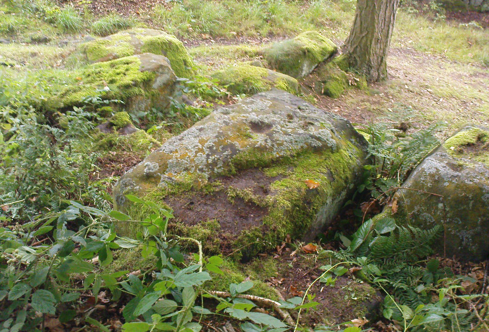
From Ilkley, take the directions up to the Panorama Woods 232 carving.  From here you can step from this rock over the stride onto the cup-marked carving 231b, and then go onto the next adjoining rock surface a little lower down. From here, you’ll see another mossy rock surface in front of you by a yard or two. That’s the one!

Archaeology & History

The three cup-markings

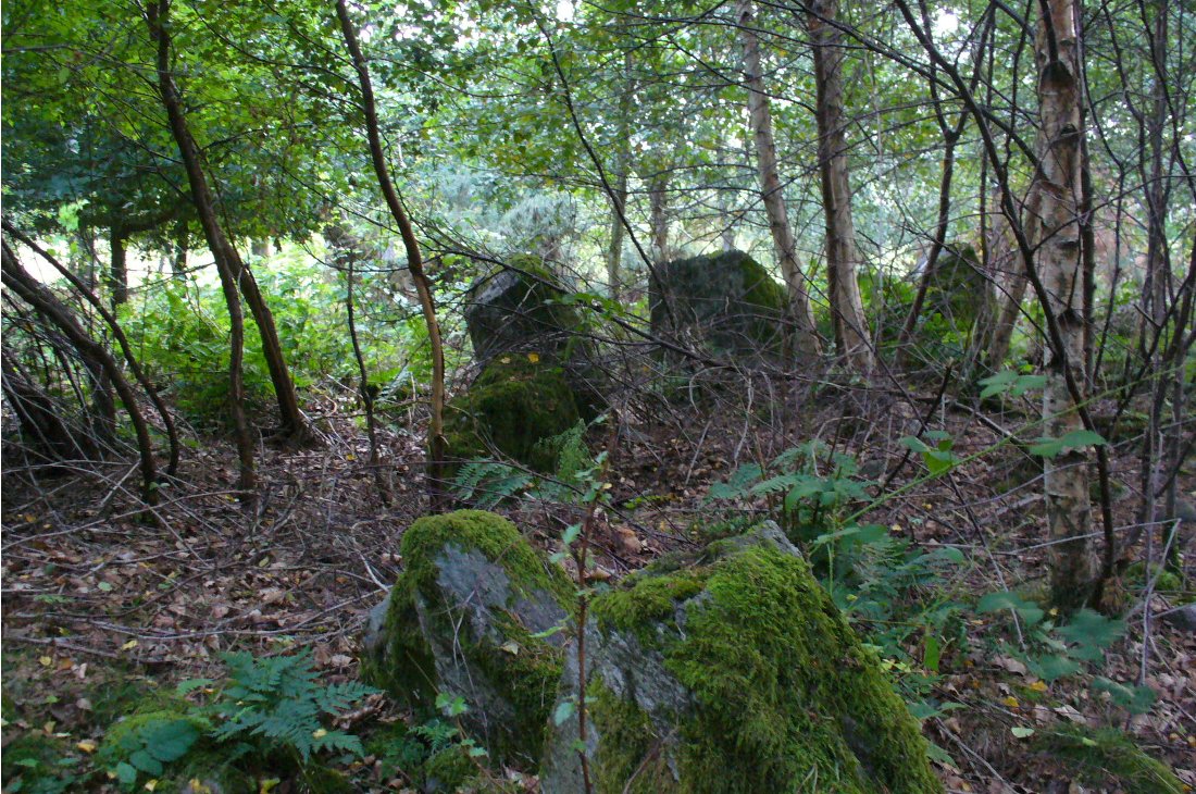
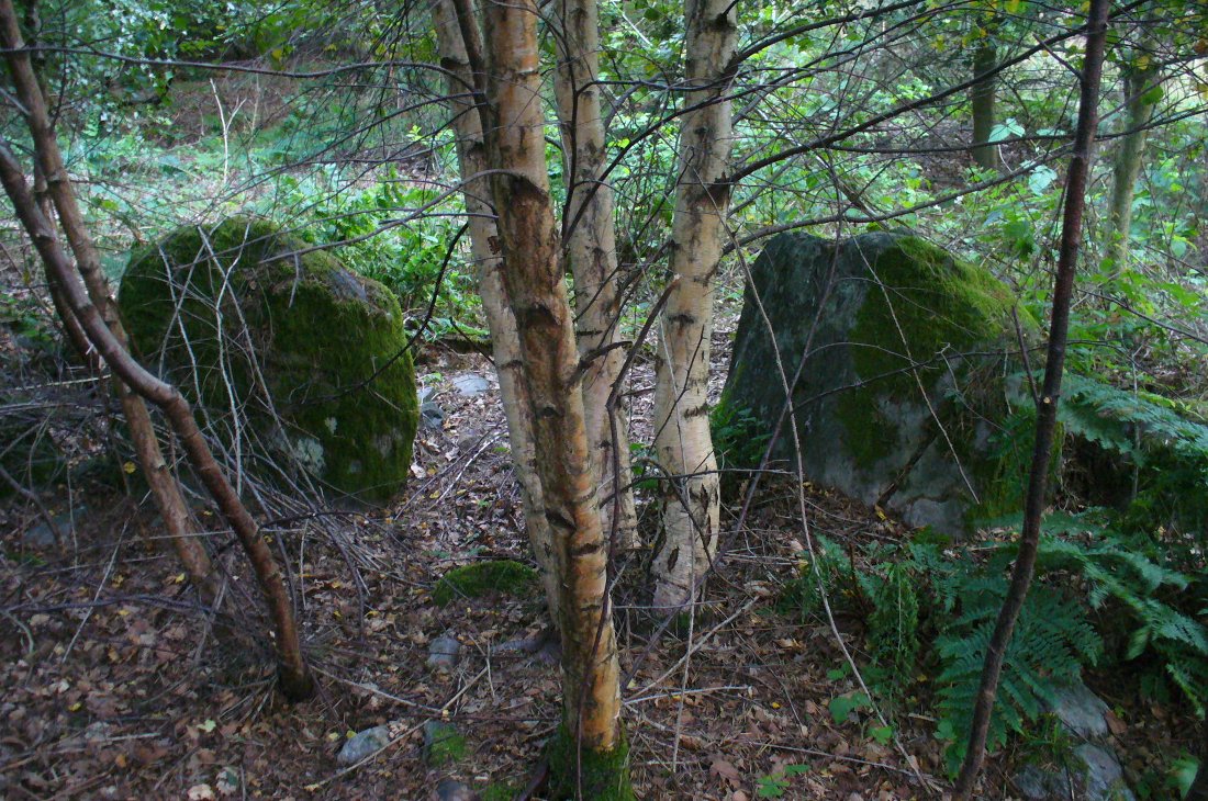
Here’s another simple cup-marked stone, probably only for the purists amongst you—although in visiting here please take into account the primary carving’s association with other more prominent designs that once existed only a few yards to the west where the houses now stand.  There is also the cluster of other carvings right next to this stone.  A prehistoric settlement was also in evidence adjacent to this carving which was destroyed in the latter half of the 19th century.

Close-up of the cups
John Hedges 1986 drawing

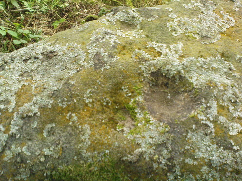
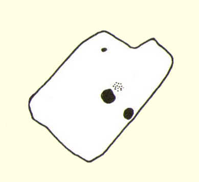
Described simply in John Hedge’s (1986) fine survey as a small “piece of rock with three clear cups and one depression.”  Boughey & Vickerman’s (2003) survey added nothing more and merely copied the same words.  For some reason or other (mebbe cos I’m simple!) I really like this otherwise innocuous design and its close simplistic relatives. It’s probably due to the trees amidst which the stones are found and the bright mosses on the rocks, giving the site a slightly extra sense of more living genius loci than others on the top of these moors, where the winds move the subtle spirits with greater ease.

19th century addition

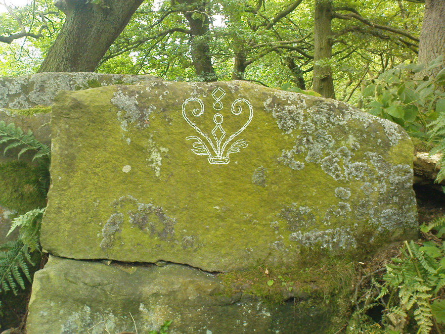
If you step down and look at the vertical side of this stone, you’ll notice a more modern stylistic carving etched onto the surface.  Not as deep as the prehistoric cups on the top, it seems probable that a local artist by the name of Ambrose Collins carved this on here (and other similar designs on other rocks nearby) in the late 19th century.

References:

  1. Bennett, Paul, The Panorama Stones, Ilkley, TNA: Yorkshire 2012.
  2. Boughey, Keith & Vickerman, E.A., Prehistoric Rock Art of the West Riding, WYAS: Wakefield 2003.
  3. Hedges, John (ed.), The Carved Rocks on Rombalds Moor, WYMCC: Wakefield 1986.

© Paul Bennett, The Northern Antiquarian


West Woods 02, Calverley, Leeds, West Yorkshire

Cup-and-Ring Stone (lost):  OS Grid Reference –SE 1956 3734

Getting Here

Old photo of lost carving

Although now seemingly lost, it’s location is damn close to this: Along the A657 between Greengates and Bradford, where the New Line meets Carr Road, the dirt-track takes you into Calverley Woods, down Eleanor Drive. About 250 yards along (just before you get to the field on the left), take the footpath down the embankment towards the stream where it bends to the left and where the land levels out (don’t cross the stream). It’s somewhere round there!

Archaeology & History

This was one of two previously unrecognised carvings we came across sometime in 1985 (see West Woods 1 stone), when we were seeking out another missing carving in the same woods.  It was clear and well-defined as the faded photo here shows; but having been back to try find it twice in the last two years in the hope of getting better photos, I’ve been unable to locate it.  The carving was described in an article I did in an old earth mysteries magazine.  It comprises simply of a large ring surrounding and enclosing two deep cups, which were linked to each other by a connecting carved line.  Parts of the stone had been chipped in parts—including a section of the large ring— due to some industrial workings that had happened here in the past. Thankfully I managed to find the old photo and hopefully, perhaps, some local explorer could try and seek out where it’s hiding beneath the trees and other vegetation.

References:

  1. Bennett, Paul, “The Undiscovered Old Stones of Calverley Woods,” in Earth no.2, 1986.

© Paul Bennett, The Northern Antiquarian


Dargill, Crieff, Perthshire

Standing Stone:  OS Grid Reference – NN 85918 20054

Also Known as:

  1. Canmore ID 25443

Getting Here

Dargill Standing Stone

Take the A822 straight road south out of Crieff and as you pass the garden centre on your right and the fields and trees begin either side of the road, you need to watch out in the field on your left-hand side.  Just a couple of hundred yards after passing beyond the garden centre, stop.  Look in the field there and you’ll see the object in question. You can’t really miss him!

Archaeology & History

As you approach or leave Crieff along the A822 you can easily pass this stone by. Which would be a pity, as it’s quite a giant standing alone just above the slight ridge in the field.  And in times gone by, not only were there other standing stones here as companions, but a cluster of other prehistoric pits, enclosures and linear markings were all around this very spot.  Some of them are visible as faint crop-marks even today, but they remain unexcavated and we are left (presently) in the dark as to their nature.

Dargill stone, looking NW
Old drawing by Fred Coles

The standing stone itself is a real beauty!  A huge fat fella, standing nearly eight feet tall, looking proudly across the field in all directions and gazing into the northern hills, where the wanderer’s eye naturally falls… In earlier years, the great megalithic explorer Fred Coles told of two other stones standing hereby—although they are not noted on the earliest OS-map of the area.  Nevertheless he wrote the following:

“This place-name deserves brief notice.  It is pronounced by persons in the locality as if it were spelt like the Irish name Dargle, having the stress on the first syllable.  The site is in a field between the main road from Crieff to Auchterarder and Dargill Island on the river Earn, at the height of 121 feet above sea-level…  There is here an indistinct mound, not now easily traceable, nor of any considerable height; but it is significant to have to report that up to 1909, when a new tenant entered the farm, two other great Stones were standing.  These were removed by the newcomer, much to the surprise and indignation (I was told) of the neighbours.  The remaining monolith is an unusually square and massive oblong block of schist, girthing over 16 feet, and standing clear of the ground 7 feet 8 inches in height.  Its eastern edge is rough and riven into long vertical hollows; but the other sides are, on the whole, smooth.  I append a view from the south-east.”

More recently the Dargill stone was described in Andy Finlayson’s (2010) excellent photo-history guide to the megaliths of the region.

Folklore

In recent years this great stone has received the attention of local ley hunter David Cowan, who dowsed here and found ‘earth energies.’ These are in fact water-lines: the primary dowsing response and not related to leys.

References:

  1. Coles, F.R., “Report on stone circles in Perthshire principally Strathearn,” in Proceedings of the Society of Antiquaries, Scotland, volume 45, 1911.
  2. Cowan, David, Ley Lines and Earth Energies, Adventures Unlimited 2003.
  3. Finlayson, Andrew, The Stones of Strathearn, One Tree Island: Comrie 2010.

© Paul Bennett, The Northern Antiquarian 


Hill of Ballunie, Kettins, Perthshire

Stone Circle (destroyed):  OS Grid Reference – NO 265 389

Also Known as:

  1. Canmore ID 30549

Archaeology & History

Looking dead straight from the Hill of Ballunie to Leys.

There seems to be nothing left of the stone circle described in Andrew Jervise’s (1879) immense work which, sadly, only described this stone circle in passing.  He told us simply that hereby, “are also the remains of stone circles upon the hill of Ballunie,” which is just a few hundred yards along the road from the magnificent Keillor Pictish symbol stone.  When we visited the place not long ago, no trace of any stones were visible hereby. The site is not listed in Burl’s (2000) magnum opus.

However, ley-hunters will love this place.  Not only was this lost circle located at the edge of a dead straight road, running from the Keillor standing stone a short distant east, but as it runs downhill it reaches, a couple of miles below, the hamlet called Leys.

References:

  1. Jervise, Andrew, Epitaphs and Inscriptions from Burial Grounds and Old Buildings in the North-East of Scotland – volume 2, Edmonston & Douglas: Edinburgh 1875.

© Paul Bennett, The Northern Antiquarian


Batty Wife Hole, Ribblehead, North Yorkshire

Ring Cairn (lost):  OS Grid Reference – SD 7622 7895

Getting Here

Old circle near Ribblehead (after Harry Speight)

The great Yorkshire historian Harry Speight (1892) gave the directions for this place, which I’ve not located.  On his walk down the southern side off Whernside, he told us to “follow the road which runs between Gunnerfleet and the white house at Winterscales, going under the long viaduct and round by Batty Wife Hole onto the main road at Ribblehead….” About 100 yards or so down the road, look over the walling into the field on the left-hand side. It’s there…..somewhere!

Archaeology & History

In an area that is pretty rich in prehistoric sites, one of our great Yorkshire antiquarians, Harry Speight (1892) seems to have described a site which our archaeologists have yet to get round to finding.  He told that,

“nearer the wall there are indications of a rude, double circle, artificially formed of these dark weathered grits.  The inner circle is about 20 yards in diameter and the outer one forms a narrow aisle surrounding it, with an outlet to the north; but some of the stones have been removed, probably to build and repair the adjoining fences.  The situation is open and commands the country on all sides between the lofty moors and summits that hem in the dale-head.  On the opposite side of the road are the remains of a couple of large cairns.  They are presumably Danish.  One was opened about a century ago (c.1790), and found to cover a rude stone coffin containing an entire human skeleton.  The other large pile does not ever appear to have been examined. It is more than probable that many a furious battel has been waged here, as the possession of this prominent ridge, which dominates so many particular outlets, must have been of capital importance to every hostile tribe.”

Although the Victorian christian beliefs of ‘rudeness’ in everything and rampant hostile tribes, has long since subsided in the view of our ancestors.  This area described by Speight does sound like an old burial ground.  But from which age – and where now are the sites he described?

References:

  1. Speight, Harry, The Craven and Northwest Yorkshire Highlands, Elliot Stock: London 1892.

© Paul BennettThe Northern Antiquarian


Caddam, Kirriemuir, Angus

Stone Circle (remains of):  OS Grid Reference – NO 3848 5625

Also Known as:

  1. Caldhame
  2. Canmore ID 32196
1865 OS-map showing the stone
1865 map showing the site

Getting Here

From Kirriemuir centre, take the B956 out of town until you hit the B955. Head north along this road until the houses are behind you. You’ll pass a woodland on your left straight away and as the road starts to bend right, take the first small road on your left. Go along here for about 150 yards and stop. Look into the fields across the road and there it is!

Archaeology & History

Caddam stone, looking north
Caddam stone, looking N

The small standing stone we see here today, within in a small fenced enclosure by the wall-side, was highlighted on the 1865 OS-map in exactly this position.  However, its earlier history seems much more intriguing – and at least one account tells us how this solitary stone was once part of something much bigger—implying that it was of some considerable important to our ancestors.  In A.J. Warden’s (1884) magnum opus on the history of this region he told that,

“A circle of stones was discovered in trenching a field at Caldhame, a little to the north of (Kirriemuir) town. It was over sixty feet in diameter, and in the centre was a large standing stone. The circle was removed, but the centre stone was left.”

The Caddam stone, looking SW
Caddam stone, looking SW

Another local writer later reported that there were remains of six stones in the field immediately below the remaining upright, but these have since disappeared. The descriptions seem to imply that the stone was a part of a burial complex of some sort.  Sadly, all we see today is this one remaining upright: some 5 feet tall, but looking shorter as it leans to its side, seemingly ready to fall.  Do any local people know anything more about this place?

References:

  1. Royal Commission on the Ancient and Historical Monuments of Scotland, The Archaeological Sites & Monuments of Central Angus, Angus District, Tayside Region, HMSO: Edinburgh 1983.
  2. Warden, Alex J., Angus or Forfarshire: The Land and People – Descriptive and Historical – volume 4, Charles Alexander: Dundee 1884.

© Paul Bennett, The Northern Antiquarian


Ninewells, Caputh, Perthshire

Ring Cairn:  OS Grid Reference – NO 0757 4360

Also Known as:

  1. Canmore ID 27115
  2. Nine Wells

Getting Here

Outer edge of the overgrown Ninewells circle

From Dunkeld, head out for a mile or so on the long and winding A923 road, taking your first road right along the Craigie and Caputh road, south of the Loch of Lowes.  Go along here for about 2 miles, watching out for the little road to Black Hill on your left, where you can park up (if you hit a road junction, you’ve gone too far). Across the road, note the copse of trees.  Go in there along the walling for about 50-70 yards, past the curious gathering of rounded stones, then walk into the trees where the giant fir trees stand. You’re damn close!

Archaeology & History

This is an excellent site, hiding away in a scattered copse of woodland, with young trees inside and very old ones in close proximity to its outer edge.  We visited the place for the first time in the middle of summer, not knowing anything about it, and found Nature had covered much of the place in Her usual clothes of fern, bramble, gorse and other vegetation.  Yet despite this, the site was superb!  In a very good state of preservation this ring of small stones is more than 30 feet across, though the stones making up the ring are only small.  Within the ring itself you’ll find many young birch trees growing over a mass of small rounded rocks, typical of cairn material such as found at other prehistoric sites of this nature up and down our northern counties, from the overgrown Roms Law, to Temple Wood and many others.  No evidence of internal burial or cist of any form was noted on our visit, nor mentioned in the Canmore survey.

Section of the Ninewells ring
Plan of the Ninewells ring (after RCAHMS)

Although rightly classed as a cairn circle or ring-cairn, I’ve seen sites like this labelled as ‘stone circles’ in the past — and it’s easy to see why once you’re inside this!  If the internal scatter of cairn-material had been cleared in earlier centuries—as with many others—this site would be classed as a typical stone circle.  Curiously it hasn’t fared too well in archaeological surveys, but thankfully the Scottish Royal Commission (1994) lads included the site in theirs, telling us,

“This cairn measures 10m in diameter and 0.75m in height and has a near-complete kerb of large contiguous boulders and slabs set on edge.  The kerb is graded so that the largest, though not the tallest stones are situated in the southwestern quadrant, and one of the stones on the west bears four cupmarks.  Today the cairn material is roughly level with the top of the kerbstones, but there is no evidence to suggest that it has been heavily robbed and it was probably never much higher.  Concentric with the kerb there is an external platform about 0.2m high.  This type of feature is more usually associated with Clava ring-cairns and passage graves around Inverness, which are believed to be of late Neolithic date; but, despite the disturbance of the centre of the Ninewells cairn, there is no evidence of stones defining an internal court.”

Two of the largest stones

Some broken quartz stones were also found inside this ring.  The cup-marked stone on the west side of the circle has an entry of its own.  Whether or not the ‘opening’ or lack of stones in the north of the ring was intentional can only be known with certainty if an excavation happens here; suffice to say that North is the airt or direction most commonly representative of the Land of the Dead in many early northern cultures, which may explain this. A truly fascinating site…

The name ‘Ninewells’ derives from a cluster of healing springs of water that once flowed nearby.  Several legendary waters with this name can be found in this part of southern Perthshire.

References:

  1. Royal Commission on the Ancient & Historical Monuments of Scotland, South-East Perth: An Archaeological Landscape, HMSO: Edinburgh 1994.

© Paul Bennett, The Northern Antiquarian


Buttergask, Kirkton of Collace, Perthshire

Souterrain:  OS Grid Reference – NO 210 340

Archaeology & History

In seeking out some of the monuments in the area north of Collace village, we enquired upon one of the landowners for anything they might know of the sites we were looking at.  Whereupon (as happens occasionally), the gent concerned—a local man—after ascertaining that we weren’t from the National Trust or a similar group, informed us that many years ago he was ploughing the field over where a small subsidence had been, when his tractor fell into a large hole that appeared in the ground due to the weight of his vehicle!  It was a souterrain, he told us; but once he managed to retrieve his tractor from the hole in the ground by calling upon one of his neighbours, he completely covered it and filled it in again.

Despite him telling us to keep it to ourselves, it does appear that aerial photography from the 1990s seems to have uncovered the location of the site.  Indeed, by the look of things, there may be more than one!

© Paul BennettThe Northern Antiquarian

Fairy Knowe, Gairneybank, Kinross, Kinross-shire

Tumulus (destroyed):  OS Grid Reference – NT 1230 9874

Also Known as:

  1. Canmore ID 51067

Archaeology & History

This is one of two sites in the county of Kinross-shire that were known as the ‘Fairy Knowe’, both of which have been destroyed through uncaring agriculture practices.  Very little is known about it.  The place was described in a lengthy footnote in the Old Statistical Account of Scotland (volume 6), which told us that,

Site shown on 1856 OS-map

“a tumulus or mound, composed mostly of earth, with some stones intermixed, on the east of Annofreuch, was opened a few years ago and a coffin found therein formed of rough flat stones, set on edge at the sides and ends, and a large one above; within which were some bones and many pieces of burnt wood interspersed.  In the memory of some old people, it was called the Elf-hillock, but is now known by the name of the Fairyknow.”

The site was listed in the Royal Commission (1933) archaeological county survey, but with no further details.

Folklore

Although the site was a resort of the little people, or faerie-folk, we have no extant tales telling us anything more.

References:

  1. Royal Commission on the Ancient & Historical Monuments, Scotland, Inventory of Monuments and Constructions in the Counties of Fife, Kinross and Clackmannan, HMSO: Edinburgh 1933.

© Paul Bennett, The Northern Antiquarian

Spink Well, Bradford, West Yorkshire

Healing Well:  OS Grid Reference – SE 1653 3410

Getting Here

The Spink Well, Bradford

From Bradford city centre go up Bolton Road (crossing the big A650 dual carriageway) until, a couple of hundred yards further you meet with, at an angle, Wapping Road on the right. Where these roads meet, note a small footpath going down into the trees on the Bolton Road side. Go down here till it bends to the right at the bottom. Walk along here for less than 100 yards, keeping your eyes peeled for the small stone-lined well above the path on your right.

Archaeology & History

The Spink Well was highlighted on the 1832 boundary commission report map of Bradford; then listed in the 1850 Tithe Awards; and of course featured on the earliest Ordnance Survey map a few years later.  In 1788, below the spring itself, a Spinkwell House was built which advertised health-giving cold baths and used the waters from this well to supply people with its health-giving virtues.  This Spink Well house also had a most curious history: the gravestones of those who died in the plague of 1645 were built into the walls of the well-house here! They were uncovered during the construction of Peel Park in the 19th century, a short distance away.  Then, for a long time thereafter, the waters and the stonework surrounding this well fell into disrepair—especially when the Industrialists appeared in what was, at the time, the world’s centre for such people.

The muddy waters of the well

The name ‘Spink Well’ is the most common of all the wells named after animals in West Yorkshire (and elsewhere in Yorkshire for that matter), with ten examples of them that I’ve come across locally.  The word ‘spink’ is the local dialect word for the finch.  A veritable profusion of them scatter our region, although not much folklore is known about this little bird.  The various types (gold finch, bull finch, etc) are all said to be birds of good fortune and one of its calls is said to tell of the coming of rain.

This particular Spink Well is very close to Bradford city centre and although now only a trickle of muddy water fills the trough into which it once ran freely, at least it’s still here!  Many other sites close to the city centre were destroyed without care by the ignorant Industrialists.  The well was evidently a place of some importance in ages past, as the 1852 OS-map shows eight spots hereby named after the place!  The local historian Roger Storrs (1888) wrote that—along with the Holy Well Ash Well a short distance from here—these sites “were long ago famous wells.”  No specific medicinal properties have been remembered for this place.

Folklore

Folklore tells that a huge boar—which gave its name to the Boar Well just 100 yards along the same path from here—also drank the waters here at Spink Well.

References:

  1. Storrs, Roger, ‘Legends and Traditions of Wells,’ in J.H. Turner’s Yorkshire Folklore Journal, 1888.
  2. Whelan, Edna & Taylor, Ian, Yorkshire Holy Wells and Sacred Springs, Northern Lights: Dunnington 1989.

© Paul Bennett, The Northern Antiquarian