The most well-known of prehistoric monuments. They are ostensibly rings of upright standing stones, generally ellipsoid in structure (Alexander Thom did the 7-category assessment), with seemingly multifunctional usage: moot sites, ritual centres and probably alignments. Generally created from the late neolithic through to Iron Age period. In this category are also included sites now defined as ‘ring cairns’ and other circular neolithic and Bronze Age monuments – but it must be stressed that the function of such sites differs from the standard megalithic rings.
The site is usually invisible, being under the waters of Walshaw Dean Middle Reservoir. But in good droughts you can catch a glimpse of the place. So take the Widdop road as it’s known locally, from either Hebden Bridge up past Heptonstall, or from Burnley, Nelson & Colne side, and park-up by the pub a few hundred yards east of Widdop Reservoir. Walk a few hundred yards back down the road (east) and take the dirt-track on the other side of the road on the Calder-Aire link leading to the Pennine Way. Walk up past the first reservoir, keeping to its west-side, until you reach the Lodge house where the second lake appears. Now, if the water’s down, walk along its western-edge for about 50 yards, looking into the dried flat ahead of you and you’ll see the loose ring of small stones. That’s it! Or as Mr Roth described the place in 1906, “The position of the circle is on the left-hand side of the valley going up, a few yards above the dam of the second reservoir.”
Archaeology & History
Earliest photo of the circle
This is a somewhat bizarre archaeological site, whose nature we may never fully recover. Although listed and scheduled as a plain stone circle by Aubrey Burl (2000) and others, both the placement and structure of the site implies a more funerary aspect to it. This was suggested by Ling Roth (1906) when he first wrote about it. But for me, the position of the site in the landscape calls into question the archetypal ‘stone circle’ category, as it is somewhat hemmed-in both east and west, with limited views north, and only a good view of open lands to the south (summer). It’s just a bit odd when compared to other megalithic rings in the Pennines. But perhaps this ‘privacy’ was intended — as there is only scattered evidence of other human activity in this valley and on the moors above. Perhaps this site was meant to be ‘cut off’ from the rest of the world. We might never know…
There is also the peculiar addition inside this stone circle of an arc of walling facing southeast, which is unique in this part of Britain. But this walling seems to have been a later addition and has the hallmarks of being some small shelter, or even an early grouse-shooting butt (there’s tons of game-birds here, and this would be an excellent spot to shoot from) This internal wall may have been constructed from stone that came from the circle itself: perhaps in a rubble wall, perhaps an internal cairn. It seems likely. Mr H. Ling Roth (1906) also mentions this feature in what was the first description of the site, where he told:
“The stone circle at Walshaw Dean Reservoir…was discovered by Mr W. Patteson, the resident engineer, in July 1902. The circle consists of ten irregular stones apparently local rock, varying considerably in size, one measured 6ft 3in (1.9m) long and stood about 30 inches (76cm) above the clay when the peat surface was removed. Whether the stones are deeply embedded has not been ascertained, but where they were covered by the peat a clear white band is apparent. The circle is 36 feet (11 metres) is diameter and of very fair exactitude. Inside the circle as shewn on the plan and in the view there was a rouhg carved wall which measured across the ends 12ft (3.7m). The wall had been partly pulled down and reset immediately before examination by a party of visitors soon after the discovery. Its presence in the circle may be fortuitous, but after the two unsystematic disturbances to which the ground had been subjected, it is not possible to form an opinion about it. That something had been buried in the centre of the circle is probable when we bear in mind the circumstances of stone circles elsewhere, but an examination shewed only that the ground had been disturbed and Mr Patteson explained to me that such disturbance was not of recent date.”
To my knowledge, no subsequent excavation of the site has ever been done, but it would appear that the waters have washed part of the site away and any remains that may once have been found within the ring have been discarded by more than a century of erosion. Traces of small walled structures have also been noted close to the circle in recent years, suggestive of settlement remains. On a TNA outing last year, we also found previously unrecorded prehistoric remains on this hills above here. When Geoffrey Watson (1952) wrote his survey on prehistoric Calderdale, he suggested that the Walshaw Circle may have been placed alongside the branch of an early trade route running along the northern edge of the valley. Not so sure misself…
References:
Bennett, Paul, The Old Stones of Elmet, Capall Bann: Milverton 2001.
Burl, Aubrey, The Stone Circles of Britain, Ireland and Brittany, Yale University Press 2000.
Roth, H. Ling, The Yorkshire Coiners, 1767-1783; and Notes on Old and Prehistoric Halifax, F.King: Halifax 1906.
Watson, Geoffrey G., Early Man in the Halifax District, HSS: Halifax 1952.
Cairn Circle (destroyed): OS Grid Reference – NM 2721 2371
Also Known as:
Angel Hill
Cnoc nar-aimgeal
Sithean More
Archaeology & History
There have long been rumours of stone circles on the druid’s isle of Iona, but many are dismissed as little more than errors on behalf of antiquarians, or false descriptions of hut circles and settlement remains. The stone circle of Sithean Mor however, does seem to have existed until only a century or two ago. It was first mentioned by the great traveller, Thomas Pennant (1776), who visited Iona more than once. He told us:
“On my return I saw, on the right hand, on a small hill, a small circle of stones, and a little cairn in the middle, evidently druidical, but called the hill of the angels, Cnoc nar-aimgeal; from a tradition that the holy man had there a conference with those celestial beings soon after his arrival. Bishop Pocock informed me that the natives were accustomed to bring their horses to this circle at the feast of St. Michael, and to course round it. I conjecture that this usage originated from the custom of blessing the horses in the days of superstition, when the priest and the holy-water pot were called in: but in latter times the horses are still assembled, but the reason forgotten.”
Site of the Sithean Mor on the 1881 OS-map
The day of the “feast of St. Michael” that Pennant mentioned was our indigenous heathen New Year, or Halloween, now usurped and misrepresented by countless plastic pagans and christians alike. It would appear from Pennant’s description that the circle in question was more likely a cairn circle. The fact that the heathen islanders celebrated annual rites here at Samhain, strongly implies there was once a hero-myth and a creation myth in evidence, but I am unaware of any remaining tales that may help confirm this. The coming of St. Columba may be responsible for this lack of oral tradition.
More than a century after Pennant’s visit here, the ring of stones had been destroyed. We know this from the description given by Archie MacMillan (1898) in his fine text on the antiquities of Iona, where he said,
“Angel Hill, called in the vernacular Sithean More. There was, not so very long ago, a circle of standing stones on the top of this hillock. They have been used for other purposes.”
Folklore
The most commonly recited tale of this grassy rise is that when St. Columba brought christianity to the island, he communed here with the angels. This is a simple displacement tale: of a new faith replacing an older one. The old name of the hill, Sithean Mor, tells that the littlepeople or fairy folk once held influence here.
References:
Cumming, C.F.G., In the Hebrides, Chatto & Windus: London 1883.
MacMillan, Archibald, Iona: Its History and Antiquities, Houlston & Sons: London 1898.
Pennant, Thomas, A Tour in Scotland, 1772 – Part 1, Benjamin White: London 1776.
At the pub by the bridge which crosses the Falls of Dochart (aptly called the ‘Falls of Dochart Inn’), walk downstream following the dirt-track which runs parallel with a section of the river for a good 5-600 yards. In the field that appears on your right, watch out for the rise of the stones as you approach the large gates which take you into the ground of Kinnell House. You can climb over the gate just into the field and go straight to the stones.
Archaeology & History
Found on the field called Kinnell Park in the grounds of Kinnell House, less than a mile out of Killin, this is a well-preserved site consisting of six stones. It appears to have been described first of all by Thomas Pennant in 1772, in the same breath as the megalithic remains at Lawers on the other side of Loch Tay. Pennant wrote:
“In going through Laurs observe a Druidical circle; less complete indeed than one, that should have been mentioned before, at Kinnel, a little southwest of Killin; which consists of six vast stones, placed equidistant from each other.”
Coles’ 1910 plan of KinnellThom’s geometric plan
It would seem that the site has changed little since Pennant’s visit. Sitting on a reasonably level grassy plain, the hills rise and surround the small ring of stones, with the lower horizons running along the south. Due west (equinox) we have the large pyramidal hill of Meall Clachach; whilst to the north are the legendary hills of Creag na Cailleach and Ben Lawers, each with their own rich mythic archaeological legacies. Legendary stones and wells are also close by, some with rites still enacted by old local people keeping truly ancient traditions alive.
The first detailed archaeological survey of the Kinnell site was done by Fred Coles and published in 1910. It has yet to be superseded. Mr Coles wrote:
“Taking the Stones in the usual order…I here give their dimensions and characteristics: Stone A, 6 feet 3 inches high, springs from an oblong base which girths 11 feet 4 inches, to a rough irregular top; Stone B leans forward towards the centre of the Circle, and measures along its sloping back 6 feet 9 inches, the present height from the ground to its upper edge being 4 feet. It is of smooth garnetiferous schist, and free from the deep fissures and rifts so common in these Stones. Stone C, a very rectangular but narrow block of schist, has a 15 Feet-girth at the base of 9 feet, but tapers up from both ends to a pyramidal summit, 5 feet 4 inches above ground. Its inner face is over 6 feet in breadth. Stone D, 4 feet 6 inches high, is a broad, flat-topped, very massive block, measuring 9 feet 5 inches round the base, but near the middle of its height 11 feet 2 inches. Stone E, the shortest of the group, is only 4 feet high, has a rough, uneven top, and a basal girth of 8 feet 11 inches. Stone F, the tallest, measures 6 feet 4 inches in height, but in girth only 7 feet 3 inches. It is very rough, vertically fissured in many places, and full of white quartz veins.
“Neat, well-defined, and comparatively small as this Circle is, it is to be noticed that the positions of the Stones do not conform to perfect regularity as points on the circumference. On working out the plan, the measurements prove that a diameter of 29 feet exactly bisects three of the erect Stones, B, C, and F, but leaves the other two untouched. The interspaces of the settings are not all quite equal, a space of 14 feet 8 inches dividing the centres respectively of F and A, A and B, F and E, and E and T); but between D and C it is 13 feet 8 inches, and between 0 and B I S feet 5 inches. Yet, the Stones stand proportionally near enough to each other to give one a satisfying impression that these six megaliths represent the group in its completeness, and that there were no smaller blocks between any two of them. The space enclosed by these stones is quite smooth and level, bearing no indication of having at any time been disturbed.”
Many years later, the late great Alexander Thom came here and, with his geometric perspective, gave a more precise ground-plan and lay-out. Thom (1980) defined the site as a “Type B flattened circle, or possible ellipse,” with a perimeter of 35 megalithic yards and diameter of 11.8 MY. Aubrey Burl’s commentary described Kinnell as:
“Six stones of schist stand evenly spaced on the circumference of an ellipse 32ft 7in x 27ft 5in (9.9 x 8.4m) in diameter. The stones are graded in height towards the SW where the two tallest are over 6ft (1.8m) high.”
One of the upright stones was said by Hugh MacMillan (1884) to have had cup-markings on it in the 19th century, when he told of the circle possessing “some seven or eight tall massive stones, with a few faint cup-marks on one of them.” But these appear to have faded, or were cut into the one of the missing stones.
Folklore
Close to the Kinnell circle could once be found a curious large boulder, covered in moss, but with a large cavity in which water gathered. Local lore ascribed the rock to actually be a well, as it was known as ‘The Well of the Whooping-Cough’, or Fuaran na Druidh Chasad, measuring some eight feet long and five feet high. Local people visited the site to be cured of the said disease, but Hugh MacMillan also suggested that the miraculous well-in-the-stone was connected with ancient rituals once enacted at the Kinnell circle, saying:
” it is a reasonable supposition that the Fountain of the Whooping-Cough may have had some connection in ancient times with this prehistoric structure in its immediate neighbourhood…”
He may have been right!
References:
Burl, Aubrey, A Guide to the Stone Circles of Britain, Ireland and Brittany, New Haven & London 1995.
Pennant, Thomas, A Tour in Scotland, 1772 – Part 2, Benjamin White: London 1776.
Royal Commission on the Ancient & Historical Monuments of Scotland, Archaeological Sites and Monuments of Stirling District, Central Region, Society of Antiquaries of Scotland 1979.
Thom, A., Thom, A.S. & Burl, H.A.W., Megalithic Rings, BAR: Oxford 1980.
Wheater, Hilary, Killin to Glencoe, Appin Publications: Aberfeldy 1982.
Although originally classed as a stone circle, this site should more accurately be described as a form of cairn circle, as burial remains were found in the middle. This is noted by both Aubrey Burl (2000) and John Barnatt (1989), who thought it to be a kerbed cairn. It’s only a small circle aswell, about 5 yards across and is found not far from other burial cairns in the neighbourhood.
First discovered around Easter in 1965 by the then owners of the farm, Mr & Mrs K. Jarman, parts of the circle were dug into by their children, who subsequently informed Sheffield City Museum of their finds. Subsequently, the circle was then described in a short article by J. Radley (1969) in ‘Notes on Archaeological Finds’ for the Yorkshire archaeology group. He wrote:
“The circle is 15ft in diameter and is made of ten stones which protrude a few inches above the turf cover. Inside the circle the ground is slightly concave. A two-feet wide trench was dug across the circle and a large stone was revealed at the centre. On the stone was a fragmented urn, remains of a cremation, and one fragment of flint. There are signs of burning on the stone, and also under the stone, but no other burial has been discovered. The whole burial was so shallow that it was in the root zone of the overlying grass. The survival of many pieces of bone in such a wet location suggests that the area must have been protected by a mound until quite recent times…
“The urn is too fragmentary to be restored. Of the hundreds of fragments, only a few retain both faces, and these are generally one centimetre thick. The urn appears to have been made of a fine clay with large grits and has a smooth brown surface marked in places with impressions of blades of grass. The urn may have been biconical in form with bands of horizontal grooves around the upper part, with vertical grooves below them.”
References:
Barnatt, John, The Stone Circles of Britain – volume 2, British Archaeological Reports: Oxford 1989.
Burl, Aubrey, The Stone Circles of Britain, Ireland and Brittany, Yale University Press 2000.
Radley, J., “A Stone Circle on Kirkmoor Beck Farm, Fylingdales,” in Yorkshire Archaeological Journal, part 167, volume 42, 1969.
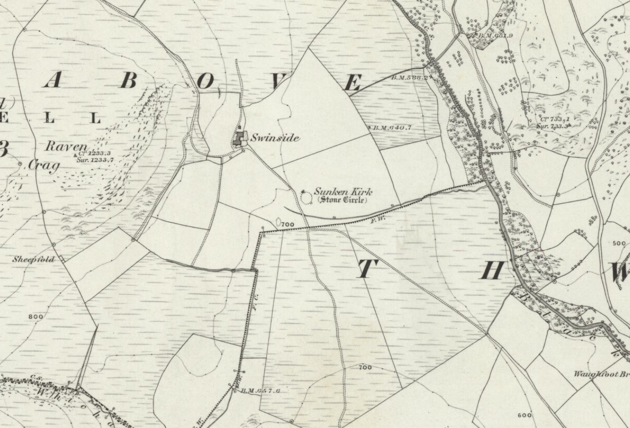
Bittova journey this — but well worth it! From Broughton-in-Furness take the A595 road west, past Duddon Bridge for about another 1½ miles, turning right up the small single-track country lane beloved of city-mind drivers, up the fertile scruffy road, past Broadgate and stopping just before Cragg Hall Farm. There’s a dirt-track running up the back of Cragg Hall. Go up here and keep walking for a mile or so until, as you approach Swinside Farm and the fields open up in front of you, the stones begin to appear.
Archaeology & History
Swinside, looking east
The Swinside stone circle is Aubrey Burl’s favourite. And for good reason! Like other impressive megalithic rings of the region, the stones are large, well set, and the landscape holds the stones finely in the hills. Without the landscape here, Swinside (like Castlerigg and elsewhere) would not have such grandeur. When you sit in the ring, or walk round it, Knott Hill to the south was of obvious mythic relevance to the people who built this stone circle four or five thousand years ago. But this can be said of many of the surrounding crags. A few miles southwest we see the top of the haunted Black Combe rising into clouds, still speaking to some with spirits from animistic realms, long known to our ancestors. Following the skyline west and past the small falls of Whicham stream, whose name speaks of long past trees, we reach the near-west skyline with the cairn-looking pap of the Raven Crag, symptomatic of magickal rites calling to and beyond the circle. To the north is the symbolic ridge of Lath Rigg. Along the craggy eastern ridges from here you get the impression that you’re more in Argyll than Cumbria; and the break in the hills to the southeast reaches to the distant pinnacle of Kirkby Moor, where the midwinter sunrise emerged to tell of solar calendrical motions and the coming of the dark season to our megalithic tribes. But enough of the landscape!
Swinside on 1867 OS-map
Although the name Swinside can be traced back to the 13th century, the local folk-name of the circle—Sunken Kirk—was mentioned for the first time as “the Chapell Suke” in Parish Registers of 1624. No earlier literary source has yet been identified, probably because of the isolation of the site and the lack of people writing about the area. Swinside stone circle is, just about, a perfect circle, give or take a foot here and there, holding the circular dome of the heavens within its domain. Yet despite its almost regal appearance, early references to the site seem scant. It seems to have been first described in William Hutchinson’s huge History of Cumberland (1794), where he told:
“In the neighbourhood of Millum, at a place called Swinside, in the estate of William Lewthwaite Esq., of Whitehaven, is a small but beautiful druidical monument; it is circular, about twenty eight yards in diameter; the stones of which it is composed are from six to eight feet high, all standing and complete. A little to the south, is another of larger dimensions, but not in so perfect a state: the neighbouring people call those places by the emphatical names of Sunken Kirks.”
A few years later, William Camden’s legendary text Britannia was edited and reprinted again, this time by Richard Gough (1806), who told:
“At Swineshead, a very high hill…is a druidical temple, which the country folk call Sunken Kirk, i.e., a church sunk into the Earth. It is nearly a circle of very large stones, pretty entire. No situation could be more agreeable to the Druids than this; mountains almost encircle it, not a tree is to be seen in the neighbourhood, nor a house, except a shepherd’s cot at the foot of a mountain surrounded by a few barren pastures. At the entrance are four large stones, two placed on each side at the distance of six feet. The largest on the left hand side is five feet six inches in height, and ten feet in circumference. Through this you enter into a circular area, 29 yards by 30. This entrance is nearly southeast. On the north or right-hand side is a huge stone of conical form, in height nearly nine feet. Opposite the entrance is another large stone which has once been erect, but is now fallen within the area: its length is eight feet. The left hand or southwest is one, in height seven feet, in circumference 11 feet nine inches. The altar probably stood in the middle, as there are some stones still to be seen, though sunk deep in the earth. The circle is nearly complete, except on the western side some stones are wanting. The largest stones are about thirty one or two in number. The outwards part of the circle upon the sloping ground is surrounded with a buttress or rude pavement of smaller stones raised about half a yard from the surface of the Earth… This monument of antiquity, when viewed within the circle, strikes you with astonishment, how the massy stones could be placed in such regular order either by human strength or mechanical power.”
Tall, northernmost stone to centreNortheast section of the ring
It seems he was impressed! Yet despite this, in the 19th century not many folk strayed this far into the western edges of Lakeland to look upon Swinside. There were occasional descriptions from travellers and antiquarians such as J.T. Blight (1843) and Edwin Waugh (1861), each speaking of the site’s visual magnitude, but it wasn’t until archaeologist C.W. Dymond came here, first in 1872 and then again in 1877, that a fuller account of the site came into being. In his essay on a “Group of Cumberland Megaliths,” he said how the stones were still in excellent condition and that,
“few of the stones seem to have been removed — probably because plenty of material for walling and road-making could be collected from the neighbouring hillside.” (Dymond 1881)
When Mr Dymond first came here he told of the remains of a rowan tree which had split one of the stones, but this has long gone. More than twenty years after the archaeologist’s first visit, he returned with R.G. Collingwood to make a more detailed evaluation of the ring. He measured and planned Swinside like it had never been done before and his ground-plan (below) is still very accurate indeed. Aubrey Burl (1999) takes up the story:
“The ring was partly excavated by Dymond, Collingwood and three men from midday Tuesday, 26 March 1901, until the close of the following evening. They dug two long, intersecting 46cm-wide trenches, NW-SE, NE-SW, across the ring with a curious zigzagging pattern of others between southeast and southwest: an investigation of some 51m² of the central area. Within the circle the trenches represented less than a thirteenth of the 642m² of the interior.
“Below the grass and turf was a thin layer of soil under which yellowish marl or ‘pinnel’ varied from 15cm to 75cm in depth, being deepest at the entrance which had been dug into earlier around 1850. Wherever it was uncovered the gravelly marl was wavily uneven, presumably the result of ploughing. The bases of the circle-stones rested on the pinnel, held firmly in their holes by small cobbles with others heavily packed around the sides. The only finds were a nut-sized lump of charcoal just northeast of the centre with others near the entrance; a minute splinter of decayed bone near the first bit of charcoal and two pieces of red stone. There were also some contemporary glass sherds and a Lancaster halfpenny dated between 1789 and 1794 lying in the uppermost turf layer.”
Dymond’s 1881 plan of Swinside
Since these early archaeological digs, Swinside has given up little else. Much like other stone circles in the British Isles, few real clues as to exactly what went on here have been forthcoming. But in the 1960s, investigations into megalithic sites made a bit of a quantum leap and some old ideas about astronomical ingredients were resurrected.
Alexander Thom’s plan of Swinside
Swinside was one of the places explored by engineer and megalith enthusiast, Alexander Thom. Thom was one of the prime figures instrumental in the resurgence of interest in megalithic sites — and his finds of megalithic astronomy and prehistoric mathematics had a lot to do with it. Although we know today that some of Thom’s work isn’t correct, his explorations and research stand him far ahead of most archaeologists who pretended to represent this area of research. He left us with the most detailed ground-plans of megalithic sites to date and, of course, showed some fascinating alignments.
Thom listed Swinside as site “L1/3” and made the most detailed and accurate ground-plan of this and 18 other megalithic rings in Cumbria. He found it to be 94 feet in diameter, with an internal area measuring 6940 square feet. The one major alignment Thom found at Swinside was of the winter solstice sunrise, lining up just on the edge of the ‘entrance’ to the circle’s southeastern side.
Folklore
Like a number of other stone circles, folklore told that you couldn’t count the stones. Janet and Colin Bord (1997) also told that people once tried to build a church here in early christian days, but once the builders went home in the evening, the Devil pulled down what they’d built during the day. A motif found at Ilkley’s Hanging Stones cup-and-ring carvings and many other prehistoric sacred sites in the country.
References:
Armstrong, A.M. et al., The Place-Names of Cumberland – volume 2, Cambridge University Press 1950.
Bord, Janet & Colin, Prehistoric Britain from the Air, Weidenfeld & Nicolson: London 1999.
Burl, Aubrey, “‘Without Sharp North…’ – Alexander Thom and the Great Stone Circle of Cumbria”, in Ruggles, Clive, Records in Stone, Cambridge University Press, 1988.
Burl, Aubrey, A Guide to the Stone Circles of Britain, Ireland and Brittany, New Haven & London 1995.
Burl, Aubrey, Great Stone Circles, Yale University Press: New York & London 1999.
Burl, Aubrey, The Stone Circles of Britain, Ireland and Brittany, Yale University Press 2000.
Dymond, C.W., “A Group of Cumberland Megaliths,” in Transactions of the Cumberland and Westmorland Antiquarian and Archaeological Society, volume 5, 1881.
Dymond, C.W., “An exploration at the Megalithic Circle called Sunken Kirk at Swinside, in the Parish of Millom, Cumberland,” in Transactions of the Cumberland and Westmorland Antiquarian and Archaeological Society, New Series volume 2, 1902.
Gough, Richard (ed.), Camden’s Britannia, J. Nichols and Son: London 1806.
Hutchinson, William, The History of the County of Cumberland – volume 1, F. Jollie: Carlisle 1794.
Seton, Ray, The Reason for the Stone Circles in Cumbria, R. Seton: Morecambe 1995.
Thom, Alexander, Megalithic Sites in Britain, Oxford University Press 1967.
Thom, A., Thom, A.S. & Burl, H.A.W., Megalithic Rings, BAR: Oxford 1980.
Waterhouse, John, The Stone Circles of Cumbria, Phillimore: Chichester 1985.
Waugh, Edwin, Seaside Lakes and Mountains of Cumberland, Alexander Ireland: Manchester 1861.
ACKNOWLEDGEMENTS:
Huge thanks to Brian Else for his photos. And to Paul and Tricia for taking us here, in awesome downpour weather!
Not included in Burl’s (2000) magnum opus, it looks as if this place has long since gone – but perhaps a local or a wanderer might find remnants of it still there somewhere. The only thing I’ve so far found about it is in Martin Martin’s journey here in 1695, where he described this “stone circle in the sea” thus:
“On the east-side of the village Rowdil, there is a circle of stone, within 8 yards of the shore: it is about 3 fathoms under water, and about 2 stories high: it is in form broader above than below, like to the lower story of a kiln: I saw it perfectly on one side, but the season being then windy, hindered me from a full view of it. The natives say that there is such another circle of less compass in the Pool Borodil, on the other side of the bay.”
Local people say that the structure is a natural one, with others of a similar nature found close by. Does anyone know more about this – and perhaps about the other apparent circle at Borasdal, less than a mile to the west?
References:
Martin, Martin, A Description of the Western Islands of Scotland in 1695, Eneas Mackay: Stirling 1934.
Stone Circle (destroyed): OS Grid Reference – SU 0986 6713
Archaeology & History
Smith’s plan of the site
This all-but-destroyed megalithic ring is all-but-unknown in most of the archaeological gazetteers — including even Burl’s (2000) magnum opus! But we know it was there. And according to the Avebury authority Pete Glastonbury , there “are a couple or three small stones buried on the hill but nothing else to see.” Which is a pity, as the site sounds like it was something to behold in bygone times. Although it seems to have been described initially by the legendary druidical antiquarian, William Stukeley, a more lengthy description followed in the 19th century by the reverend A.C. Smith (1885), when he and a friend took it upon themselves to cut back some of the turf that was covering a number of stones — and they weren’t to be disappointed!
The site itself appears to have stood right on the southern boundary line of Avebury parish, meaning that the site could have been named and cited on any early boundary perambulation records that might exist of the parish. (do any of you Wiltshire folk have access to any such old records?) But if there are no such early accounts, the earliest record we’ll have to stick with is good old Mr Stukeley (1743), who only gave it a passing mention, saying:
“Upon the heath south of Silbury was a very large oblong work like a long barrow, made only of stones pitch’d in the ground; no tumulus. Mr Smith before-mentioned told me his cousin took the stones away (then) fourteen years ago, to make mere (boundary, PB) stones withal. I take it to have been an Archdruid’s, tho’ humble, yet magnificent; being 350 feet or 200 cubits long.”
Nearly 150 years later Reverend Smith gave us a more detailed account, and ground-plan, describing the place as,
“a stone circle, of considerable dimensions, though imperfect and formed of very small sarsens, but which I believe to have been in some way connected with Abury. Though it appears to have been mentioned by Stukeley one hundred and fifty years ago, it had been long since buried, and completely forgotten till I was fortunate enough to discover it by digging in the year 1877. I was led to the discovery by the suspicious look of certain stones which, though scattered in no regular form, appeared as if they might have once stood erect, in some sort of order, on the segment of a large circle. I had often stopped to examine them as I wandered over that part of the downs; till at last previous suspicions ripened into conviction, as closer observation revealed sundry other stones just showing above the ground, and there also seemed to be faint indications of a trench, all pointing, with more or less accuracy, to the supposed circle. Not to dwell upon the details of the investigation, which, however, were of singular interest to me, the result was that (with the permission of both owner and occupier of the land, and assisted by Mr William Long), I probed the ground in every direction, and uncovered the turf wherever a stone was found: and on our first day’s work we unearthed no less than twenty-two sarsen stones, all forming part of the circle, and lying from two to twelve inches below the surface. These stones were all of small size, some of them very small, but that they were placed by the hand of man in the positions they now occupy, in many cases nearly touching one another, and that they formed part of a large circle or oblong, admits, I think, of no doubt. I say part of a circle, because, though the northern, southern and eastern segments are tolerably well defined, I could find scarcely a single stone on what should be the western segment to complete the circle. That the area thus enclosed is not insignificant will appear from the diameter (in length, or from north to south, 261 feet; and in breadth, or from east to west, 216 feet). Again, its position (due south of Silbury, and within full view of it, as well as the Sanctuary on Overton Hill, and with Abury immediately behind Silbury, due north of it, from which also Silbury is equidistant) seems to intimate that it may have had some connection with the great temple.”
A ley running through the circle (image courtesy Paul Devereux)
Smith then proceeded to query the nature of the monument, commenting on how Sir John Lubbock and members of the British Archaeological Association were intrigued by the remains, but a little perplexed and unable “to form any opinion” as to the exact nature of the site. But this didn’t stop mythographer and historian Michael Dames (1977) who, in his classic Avebury Cycle, suggested that the site “marked the navel of the landscape goddess” in the region.
The site didn’t go unnoticed in Devereux and Thomson’s (1979) classic Ley Hunter’s Companion, where it plays an important point along a ley that runs north-south for 13 miles between Bincknoll Castle at the north, to Marden Henge at the south. Such an alignment had been noted much earlier by other archaeologists and historians.
The site does look strange for a stone circle in Smith’s ground-plan and has more the hallmarks of a type of enclosure or settlement of some sort. It certainly wouldn’t be out of place, design-wise, as a prehistoric settlement in our more northern climes. However, without further data it seems we may never know the true nature of this old stone site…
References:
Dames, Michael, The Avebury Cycle, Thames & Hudson: London 1977.
Devereux, Paul & Thomson, Ian, The Ley Hunter’s Companion, Thames & Hudson: London 1979.
To get here, follow the same directions to reach its nearby colleague of Carse Farm south — but instead of walking down the track to where its companion is found, this small ring of stones is found a coupla hundred yards into the first field by the roadside. Unless the field’s fulla corn (in which case, give it a miss cos even if you do find it, you won’t be able to make much out), y’ can’t really miss it!
Archaeology & History
As with its nearby companion of Carse Farm south, this small “ring” of four stones is found along the Tay valley floor and, though cited as a stone circle in many archaeology tomes, should more accurately be defined as a cairn circle of sorts. Structurally akin to other four-posters, it reminded me of a distant companion in North Yorkshire more than 200 miles south: the Druids Altar at Bordley, which is also a robbed prehistoric tomb and not a stone circle. But it’s a fine little site sat amidst the majestic temple of surrounding hills on all sides, bar east, where the Tay valley reaches into the distance.
Faint cup-marksCarse Farm, looking north
Like its damaged companion in the field below, some of the stones in this circle also have well-defined cup-markings on top of the uprights; although when we visited here, low cloud and late daylight conditions prevented us from getting good images of the cup-marks concerned (as the photo of one of them here illustrates). The cup-markings are, curiously, carved on the top of the small standing stones.
Described briefly in Alexander Thom’s Megalithic Rings (1980), he regarded its geometry as “circular” in structure. Aubrey Burl (1988) gave the lengthier archaeological history of the site, telling:
“On the ‘carse’, or lowland…this 4-poster was excavated in 1964. When Coles saw it in 1907 only three smallish stones remained standing although “it seems clear that at this site there were originally four Stones as in so many other Perthshire groups”… The SW stone was missing but halfway between the NW and SE stones a long, thin slab lay half-buried.
“Coles noticed that there were cupmarks on the tops of both the NE and SE stones. The SE had three carvings but the top of the NE had no fewer than 17, the largest ‘cup’ being 4 by 3½in (10 x 9cm). In the group were two ‘dumb-bells’. In the same field the farmer had dragged away a buried stone which was also cupmarked.* (my italics, PB)
“Of the three standing stones, the NE is 3ft 11in (1.2m) high; the SE, 5ft 1in (1.6m); and the NW, 4ft 1in (1.3m). These heights…are almost double those cited by Coles (1908: 126).
“”The 1964 excavation discovered the SW stonehole. The 5ft 10in (1.8m) long stone lying at the centre of the 4-Poster was erected in it, a task made easier by the fact that its base had been keeled… The base was unweathered showing that the stone had been toppled in quite recent times as had the stones of the two Fortingall 4-Posters…3¾ miles to the WSW. The four stones stood at the corners of a rectangle 12ft by 8ft (3.7 x 2.4m) on a long ENE-WSW axis. They also stood on the circumference of a circle 14ft 5in (4.4m) in diameter.
“A tapering pit was discovered against the inner face of the NE stone, about 2ft 6in (76cm) across and 1ft 2in (37cm) deep. It was filled with cremated bone and sticky black earth and charcoal. At the bottom, a collared urn lay on is side, its rim decorated in geometrical designs. A flint flake lay near it. Within the 4-Poster there were three shallow pits, two between the NW and NE stones, another between the SE and SW. Their edges were clean and they had been backfilled with brown loam. The excavators thought they might have “been used for stabilising props during the erection of the stones.” …As the heaviest block, that at the NW, weighed about 6 tons it would have required 20 to 30 people to drag it upright…and the use of such props would have made their insertion safer.”
Unless the people building this site were dwarves, we’ve gotta re-assess this latter remark (which Burl quotes from the earlier archaeologist’s report from the 1960s). Having personally been involved with the creation of modern stone circles with stones larger than the ones here, we know that the uprights here could have been erected by 8-10 people at the very most.
Archaeology and folklore records describe many other prehistoric sites along this section of the upper Tay valley, but it’s also very likely that other “circles” or cairns of similar structure to the two known at Carse Farm once existed close by that are not in modern literary accounts.
References:
Burl, Aubrey, Four Posters: Bronze Age Stone Circles of Western Europe, BAR 195: Oxford 1988.
Pretty easy to find – assuming it aint at the height of summer and the crops are approaching maturity, otherwise you’re only gonna see its head! But, this aside: from Aberfeldy, take the B846 road over the river bridge that bends you along the valley of the River Tay towards Appin of Dull. After some 2 miles you’ll pass the right-turn up to Dull. Go past this for another coupla hundred yards or so, watching out for the left-turn down towards the farmhouse of Carse and park up where you can (if you go past it, there’s the second turn up to Dull, again on your right, where you can turn round). As you walk down the track towards Carse Farm, watch out on your right in the field below Carse I, in the second field down. You can’t really miss it. (and the farmer here is spot on if you ask to check the stone – as long as the crops aint growing)
Archaeology & History
Although all that’s left of what is thought to have been a once proud stone circle is the singular upright standing stone in the middle of the field. Aubrey Burl (1988) thought that this was one of the typical “four poster”rings that scatter our isles, but I’m not so sure misself. There were other stones associated with the site when Burl described it, but these were covered over in our visit here a few months back — which is a pity, as two of the stones are reported as possessing cup-markings (if/when we revisit the site, I’ll try get some images of the respective stones and add them on TNA as individual carved stones). The site gives the distinct impression of it having a funerary character of some sort and not a true stone circle — and this was strongly suggested by some of the finds inside the “ring”, described below.
Fred Cole’s old drawingAubrey Burl’s groundplan
Both this and its associated “circle” a few hundred yards away — known as Carse Farm north — sit on a flat level of ground in the Tay valley, with rounded hills all most sides. This landscape setting was obviously of some importance to the people who put the circle here in the first place but, not living in the region, it’s difficult to assess the mythic relevance some of the hills will have obviously played in the siting of these stones.
In bygone days, it was reported that the much of the site was ploughed away due to agricultural excesses, so there was obviously much more to it in earlier centuries. Describing the solitary stone that’s left today, along with the earlier excavation results, Mr Burl (1988) wrote:
“The stone still standing, of quartziferous schist, is 6ft 3in (1.9m) high. Its longer faces are aligned NW-SE. 32ft 6in (9.9m) to its SW is a large prostate block, sub-elliptical and about 8ft long and 4ft 3in wide (2.4 x 1.3m). It has probably fallen outwards. (my italics, PB) If so, when standing near the top of its inner face were four cupmarks in a cross pattern.
“About 32ft ((9.8m) to its NW is a fallen and enormous schist slab, 11ft long and 5ft wide (3.4 x 1.5m). It also appears to have toppled outwards. Near the bottom of its inner face are two cupmarks. The situation of these three stones suggests that they once stood at the corners of a rectangle some 32ft (9.8m) square, the pillars of a huge four-poster nearly six-times the national average and with an internal area ten times bigger than the small 4-poster (Carse Farm north, PB) just to its north.
“Excavation in 1964 found the socket from which the great prostrate slab had been dragged… Cash (1911) had noted the presence of a small stone inside the ring about 20ft (6.1m) west of the standing stone. It proved to be 4ft (1.2m) square with a carefull-dressed face. It had been set upright, standing about 1ft 4in (41cm) above the ground. Three sides of the worked face ‘had been carefully chiselled away to a straight edge.’ It may have been a slab lining the inner central space of a destroyed ring-cairn. Burnt bone was found near it. There was also a rounded river pebble with a worked hollow on one side…”
Folklore
Carse Farm stone
Stewart (1964) described the site as having been “christianized” not long ago, by having the northernmost standing stone in the ring removed. This is intriguing inasmuch as “north” is the place of greatest symbolic darkness in the pre-christian mythos, and represented death and illumination in magickal terms. North was also the point taken by witches and shamans in their excursions into Underworlds, usually via the North Star, which tethered the Earth to the heavens (see Godwin’s Arktos [1993], and Grant, The Magical Revival [1973]) In the removal of this northern stone for the reasons given, that implies some magickal events or folklore were in evidence here when this took place. Anyone got any further information along these lines, or has it long since been subsumed?
References:
Burl, Aubrey, Four Posters: Bronze Age Stone Circles of Western Europe, BAR 195: Oxford 1988.
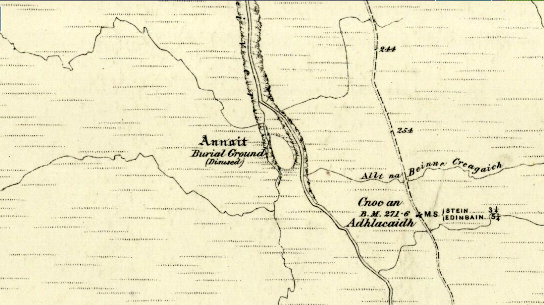
Otta Swire (1961) told how to find this place, thus: “The Waternish road turns off to the north at Fairy Bridge, whence it runs along the valley of the Bay river. On the left of the road, though at some little distance from it, where the river cleaves its way through a gorge to the sea, stands the mound which is now all that remains of the ‘Temple of Anaitis’ (so called).”
Archaeology & History
This is a curious place, full of archaeological potential if the folklore and history records are owt to go by, yet little of any substance remains to substantiate what may have been an important stone circle or other heathen site in earlier times. It seems to have been described first of all in the famous Hebridean journeys of Boswell and Johnson in the late 18th century. Amidst his insulting description of both the landscape and local people, on Friday 17th September 1773, James Boswell visited the site and told:
“The weather this day was rather better than any that we had since we came to Dunvegan. Mr M’Queen had often mentioned a curious piece of antiquity near this which he called a temple of the goddess Anaitis. Having often talked of going to see it, he and I set out after breakfast, attended by his servant, a fellow quite like a savage. I must observe here, that in Skye there seems to be much idleness; for men and boys follow you, as colts follow passengers upon a road. The usual figure of a Sky boy, is a lown with bare legs and feet, a dirty kilt, ragged coat and waistcoat, a bare head, and a stick in his hand, which, I suppose, is partly to help the lazy rogue to walk, partly to serve as a kind of a defensive weapon. We walked what is called two miles, but is probably four, from the castle, till we came to the sacred place. The country around is a black dreary moor on all sides, except to the sea-coast, towards which there is a view through a valley, and the farm of Bay shews some good land. The place itself is green ground, being well drained, by means of a deep glen on each side, in both of which there runs a rivulet with a good quantity of water, forming several cascades, which make a considerable appearance and sound. The first thing we came to was an earthen mound, or dyke, extending from the one precipice to the other. A little farther on, was a strong stone-wall, not high, but very thick, extending in the same manner. On the outside of it were the ruins of two houses, one on each side of the entry or gate to it. The wall is built all along of uncemented stones, but of so large a size as to make a very firm and durable rampart. It has been built all about the consecrated ground, except where the precipice is deep enough to form an enclosure of itself. The sacred spot contains more than two acres. There are within it the ruins of many houses, none of them large, a cairn, and many graves marked by clusters of stones. Mr M’Queen insisted that the ruin of a small building, standing east and west, was actually the temple of the goddess Anaitis, where her statue was kept, and from whence processions were made to wash it in one of the brooks. There is, it must be owned, a hollow road visible for a good way from the entrance; but Mr M’Queen, with the keen eye of an antiquary, traced it much farther than I could perceive it. There is not above a foot and a half in height of the walls now remaining; and the whole extent of the building was never, I imagine, greater than an ordinary Highland house. Mr M’Queen has collected a great deal of learning on the subject of the temple of Anaitis; and I had endeavoured, in my journal, to state such particulars as might give some idea of it, and of the surrounding scenery” —
But in all honesty it seems Mr Johnson was either too lazy to write about the place, or simply didn’t actually get there, in spite of what he alleged! But later that evening, Boswell dined with the same Mr MacQueen, who told him more of this site. In the typically pedantic tone of english supremacy (which still prevails in some idiots who visit these lands), he continued by saying:
“Mr Macqueen had laid stress on the name given to the place by the country people, Ainnit; and added, ” I knew not what to make of this piece of antiquity, till I met with the Anaitidis delubrum in Lydia, mentioned by Pausanias and the elder Pliny.” Dr. Johnson, with his usual acuteness, examined Mr Macqueen as to the meaning of the word Ainnit, in Erse, and it proved to be a water-place, or a place near water, “which,” said Mr. Macqueen, “agrees with all the descriptions of the temples of that goddess, which were situated near rivers, that there might be water to wash the statue.”
There ensued a discussion between Mr MacQueen and Samuel Johnson about the etymology of Anaitis, with one thinking it was of a goddess, and another that it represented an early christian site. To this day it is difficult to say what the word means with any certainty. In W.J. Watson’s (1993) fine work he tells us,
“Andoit, now annaid, has been already explained as a patron saint’s church, or a church that contains the relics of the founder. This is the meaning in Ireland and it is all we have to go upon. How far it is held with regard to Scotland is hard to say… They are often in places that are now, and must always have been, rather remote and out of the way. It is very rarely indeed that an Annat can be associated with any particular saint, nor have I met any traditions connected with them. But wherever there is an Annat there are traces of an ancient chapel or cemetery, or both; very often, too, the Annat adjoins a fine well or stream…”
The great Skye historian and folklorist Otta Swire (1961) also wrote about this mysterious site, mainly echoing what’s said above, but also adding:
“This name of Annait or Annat is found all over Scotland. It has been interpreted as meaning the ‘Water-place’ from Celtic ‘An’ = water, because many are near water. Others suggest ‘Ann’ = a circle (Celtic) and claim that most Annats are near standing stones. The most-favoured derivation seems to be from Ann, the Irish mother of the Gods, and those who hold this view claim that the Annats are always near a revered spot, where either a mother-church or the cell of a patron saint once stood. Probably Annat does, in fact, come from an older, pre-Celtic tongue, and belongs to an older people whose ancient worship it may well commemorate. The curious shape of the Waternish Temple of Anaitis and its survival make it seem likely that it was something of importance in its day, built with more than usual care and skill. Perhaps the Temple tradition is correct – but whose, if so, and to what gods? One cannot help wondering if cats played any part in its ritual, and if so, if any faint memory remains, for the nickname of the people of this wing was ‘Na Caits’ = The Cats, and not far off, by one of the tributary burns on the right of the roadway, there stands a small cairn, crowned by a long, sharp stone somewhat resembling a huge claw. This is the ‘Cats’ Cairn’.”
The Cats’ Cairn (NG271526) is said to mark the grave of a young boy from the 18th century, who was buried where he died and its story is told elsewhere on TNA. Another example of the Annait place-name can be found elsewhere on Skye at the megalithic site, Clach na h’annait.
References:
Boswell, James, The Journal of a Tour to the Hebrides with Samuel Johnson, National Illustrated Library: London 1899.
Swire, Otta F., Skye: The Island and its Legends, Blackie: Glasgow 1961.
Watson, W.J., The History of the Celtic Place-Names of Scotland, Birlinn: Edinburgh 1993.


")
")
")


")
")