To search for any sites in the northern counties of England (previously known as Brigantia), click on the list of relevant counties, below. Please note that not all these english counties were truly in Brigantia, but they came close to its southern edges; and as parts of them tickle the edges of the southern Pennines, I thought they should be included. Hope that’s OK with everyone!
If you’re a bittova unhealthy dood, give this site a miss, as it takes a bitta getting to! Otherwise, get to the rocks at the very bottom of the Druid’s Altar and walk to the right (east) until you hit the walling a few hundred yards along. Near the bottom of the slope, where the land levels out, there are several lovely moss-strewn boulders in their music of graceful hues. One of them, you’ll see, has water emerging from it base. You’re here!
Archaeology & History
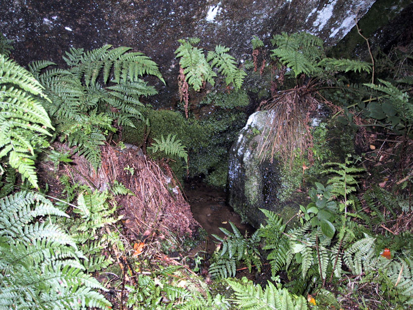
The Druid’s Well
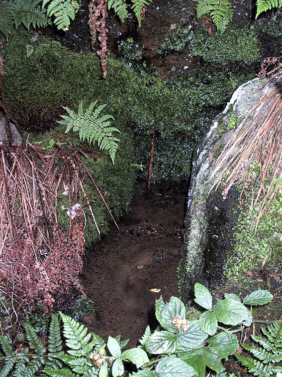
I first visited this old site with the holy wells writer Edna Whelan sometime in the early 1980s, when we went in search of the sacred spring of water known as the ‘Altar Well,’ shown on early maps to be just a short distance beneath the small cliffs called the Druid’s Altar. We didn’t find it! Another visit with Graeme Chappell and Edna (again) sometime later also proved fruitless – but something else was found which we didn’t know about on our first sojourn: the Druid’s Well, or more accurately the Druid’s Spring. (no stone trough y’ see) Not far from the spot that the Altar Well could once be seen, this beautiful spring of sweet water emerges beneath the rich lichen-encrusted boulder, painted with dappled mosses and an overhang of vivid ferns. Tis a fine oracular site, if ever there was one!
The waters run slowly from beneath the great old rock, upon which grows a fine specimen of a birch tree – a truly old thing! And if there was ever any truth about this regions association with the druids, one of their most important sacraments grows profusely here when the season is right: no, not mistletoe (though it can be found sparingly upon the old oaks), but a wealth of the sacred Amanita muscaria, to whose spirit visionary journeys were bestowed.
Close-up of the waters beneath the boulder
The name of the woodlands in which our Druid’s Spring emerges — the Hollin Wood — might also have had some associative relationship with this well, or the Altar above (modern maps call it the Hollin Plantation, as much of the old woods have been felled and copsed by modern man). Place-name texts ascribe this to be the ‘woodland of holly trees’, but during our wander through the woods a few weeks ago (when we got the photos of the Druid’s Well) holly trees were not common. It may be that the Hollin Wood originally derived from ‘holy wood’, as this old well and the Druid’s Altar above would have surely made the site sacred to the druids. Just a thought. We will probably never know (if someone finds out for sure, one way or t’other, lemme know and I’ll amend where necessary!).
References:
Greenbank, Sydney, The Druid’s Altar, Bingley, R.G. Preston: Bingley 1929.
Speight, Harry, Chronicles and Stories of Old Bingley, Elliott Stock: London 1898.
Whelan, Edna & Taylor, Ian, Yorkshire’s Holy Wells and Sacred Springs, Northern Lights: Dunnington 1989.
Various routes to this giant tomb, which happens to be a way off the roads (thankfully!). Probably the easiest way is from the Menston-side: up Moor Lane, turn left at the end, go 200 yards and take the track onto the moor. Just keep walking. If you hit the rock-outcrop nearly a mile on, you’ve gone past your target. Turn back for about 400 yards and walk (south) into the heather. You’re damn close!
Archaeology & History
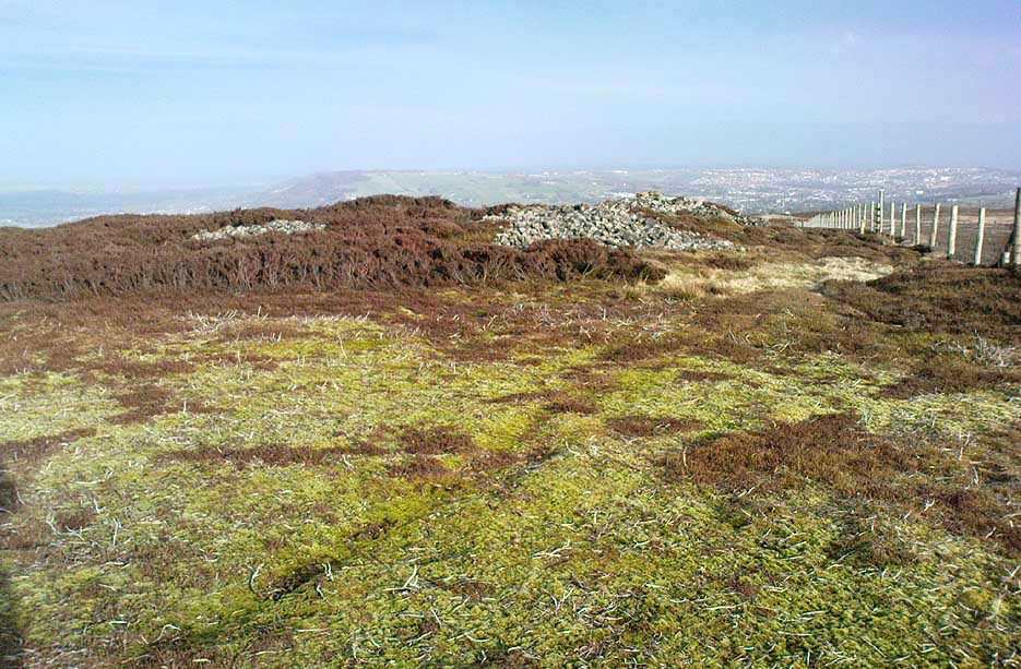
Great Skirtful of Stones cairn looking east to Otley Chevin
Due north of the Skirtful Spring water source, this is one of Ilkley Moor’s major prehistoric sites: ‘major’ for a number of reasons – not least of which is the size of the thing! Although getting somewhat overgrown these days as more of the heathlands encroach the mass of rocks that constitute the central ‘tomb’, it is still a formidable heap. Another reason this site is of importance is its position in the landscape: it can be seen as the peak or ‘nipple’ on the landscape from considerable distances north, south and east of here, rising up on the horizon and catching the eye from many miles away. This was obviously quite a deliberate function of the site when it was first constructed – thought to be in the Bronze or Iron Age period (sadly we have no decent excavation here to tell us just when it was made). Another reason for its importance is its position relative to a once huge prehistoric graveyard immediately east. And right next to it we also find a curious circular monument that has never been properly excavated, whose function is unknown. It is also the seeming focal point of at least one, though possibly three prehistoric trackways: one of which goes right past it, though swerves on its southern edge quite deliberately so as to not touch the monument. This trackway appears to have been a ceremonial ‘road of the dead,’ along which our ancestors were carried, resting for some reason at the nearby Roms Law, or Grubstones Circle, a few hundred yards to the west.
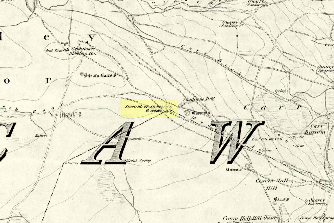
Wrongly ascribed as a “round barrow” by archaeologist Tim Darvill (1988), the Great Skirtful cairn was named in boundary changes made in 1733, where one Richard Barret of Hawksworth told that the site was “never heard go by any other name than Skirtfull of Stones.”
In 1901 there was an article in the local ‘Shipley Express‘ newspaper — and repeated in Mr Laurence’s (1991) fine History of Menston and Hawksworth — which gave the following details:
“Mr Turner led the way across Burley Moor to the Great Skirtful of Stones, a huge cairn of small boulders, nearly a hundred tons on a heap, although for centuries loads have been taken away to mend the trackways across the moor… The centre of the cairn is now hollow, as it was explored many years ago, and from the middle human bones were taken and submitted to Canon Greenwell and other archaeologists” – though I have found little in Greenwell’s works that adequately describe the finds here. Near the centre of the giant cairn is a large stone, of more recent centuries, which once stood upright and upon which is etched the words, “This is Rumbles Law.” The Shipley Express article goes on: “Mr Turner explained that ‘law’ was always used in the British sense for a hill, and Rumbles Hill, or cairn, was a conspicuous boundary mark for many centuries. He had found in the Burley Manor Rolls, two centuries back, that on Rogation Day, when the boundaries were beaten by the inhabitants, they met on this hill, and describing their boundaries, they concluded the nominy by joining in the words, “This is Rumbles Law.””
Great Skirtful on 1851 map
Several other giant cairns like this used to be visible on the moors, but over the years poor archaeological management has led to their gradual decline (and in editing this site profile in 2016, have to report that poor archaeological and moorland management is eating into and gradually diminishing this monument to this day). We still have the Great Skirtful’s little brother, the Little Skirtful of Stones, a half-mile north of here. The very depleted remains of the once-huge Nixon’s Station giant cairn can still be seen (just!) at the very top of Ilkley Moor 1½ miles (2.65km) west.* And we have the pairing of the giant round cairn and long cairn a few miles west on Bradley Moor, near Skipton. The tradition of such giant tombs on these hills was obviously an important one to our ancestors.
Folklore
We find a curious entry in the diaries of the Leeds historian Ralph Thoresby, in the year 1702, which seems to describe the Great Skirtful of Stones, adding a rather odd bit of folklore. (if it isn’t the Great Skirtful, we’re at a loss to account for the place described.) Mr Thoresby told how he and Sir Walter Hawksworth went for a walk on Hawksworth’s land and said how,
“he showed us a monumental heap of stones, in memory of three Scotch boys slain there by lightning, in his grandfather’s, Sir Richard Hawksworth’s time, as an old man attested to Sir Walter, who being then twelve years of age helped to lead the stones.”
As far as I’m aware, this old story of the three Scottish boys is described nowhere else.
Like many giant cairns, the Great Skirtful has a familiar creation myth to account for its appearance. In one version we hear that it was made when the local giant, Rombald (who lived on this moor) and his un-named wife were quarrelling and she dropped a few stones she was carrying in her apron. A variation swaps Rombald’s wife with the devil, who also, carelessly, let the mass of stones drop from his own apron to create the ancient cairn we still see today.
According to Jessica Lofthouse’s North Country Folklore (1976), a Norse giant by the name of Rawmr, “fell fighting against the Britons of Elmet and is buried, they say, on Hawksworth Moor” – i.e., the southeastern section of Rombald’s Moor, very probably at the Great Skirtful of Stones. I’ve yet to explore the history and etymology of the name Rawmr…
References:
Bennett, Paul, The Old Stones of Elmet, Capall Bann: Chieveley 2001.
Cowling, Eric T., Rombald’s Way, William Walker: Otley 1946.
Darvill, Timothy, Ancient Britain, AA: Basingstoke 1988.
Laurence, Alastair, A History of Menston and Hawksworth, Smith Settle: Otley 1991.
* Whoever is/was supposed to be responsible for the care of the Nixon’s Station giant cairn monument should be taken to task as it’s been virtually obliterated since when I first came here 30 years ago. Which useless local archaeologist and/or council official is responsible for its destruction? Who allowed it to happen? Why are Ilkley Moor’s prehistoric monument’s being so badly looked after by those who are paid to ensure their maintenance? Are their heads up their arses, in the sand, or—don’t tell me—the prawn sandwiches are to blame!?
This giant site—deemed as Iron Age by some and medieval by others—is on the verge of complete destruction as the adjacent quarrying company cuts closer and further into the sides and top of the monument. Local people and archaeologists need to do something about this, or it will be lost forever as the Industrialists once again destroy more of our ancient heritage in order that they can feed their god of Money.
Folklore
Legend has always told that great treasure existed beneath the grounds of this Brigantian hillfort, found on the moor-edges to the east of Manchester. Long ago, one man came along to see if he could find the treasure, said to consist of a huge chest of gold. The man brought two horses and the ground within the fort was gradually cleared away until, to the man’s surprise, the legendary chest was revealed!
Attaching chains to it and the horses, the man shouted:
“Gee, whoa, whoo! Bonny, Buck and Bell,
I’ll have this chest o’ gowd, i’ spite o’ all t’ devils in hell!”
But barely had the words left his mouth and the chest began to move, when the devil himself appeared in the shape of a huge hen that breathed fire! This scared the horses so much that they bolted and snapped the chains, taking their master with them but leaving the treasure-chest still in the ground. To this day the chest still remains, hidden in the Earth.
References:
Winterbottom, Vera, The Devil in Lancashire, Cloister: Stockport 1962.
Cairn (destroyed): OS Grid Reference – NZ 6950 1886
Archaeology & History
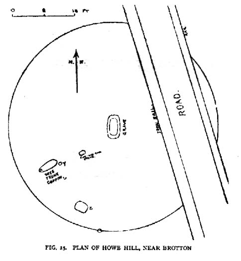
Frank Elgee’s 1930 plan
Another old site that has sadly succumbed to that bollox called ‘progress’! It’s in the North Yorkshire region some halfwits have taken to calling Cleveland — but which a lotta local folk still correctly call Yorkshire. But that aside…
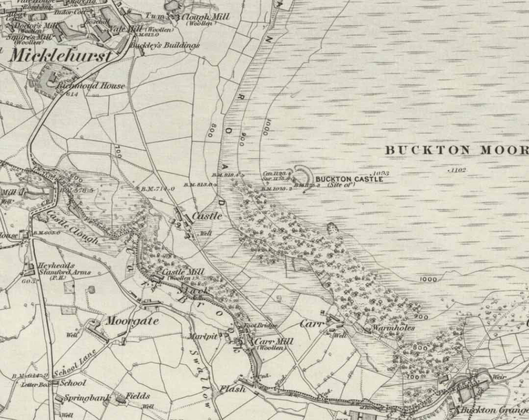
In an article by local students William Hornsby and Richard Stanton written in 1917, we find that this was just one of at least seven hillocks presumed to be barrows here — but all the others had gone even in their day. When Crawford (1980) came to survey the site in the late 1970s, he told that,
“this large barrow is now only visible as a low swell in an arable field… (but) the profile of the barrow is retained in the hedgeline that bisects it from north to south, but the whole of its eastern half has been obliteratd by the Brotton-Kilton road.”
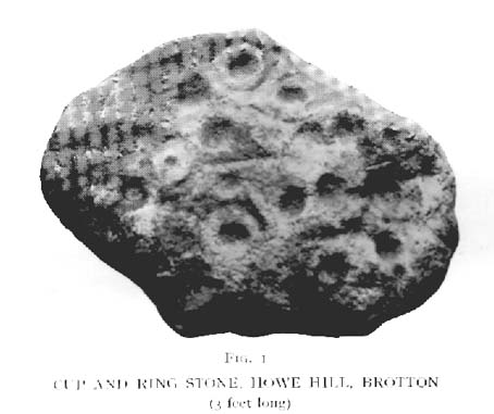
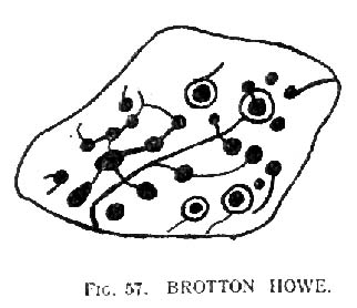
Elgee’s 1930 photo of one of the carvingsE.T. Cowling’s drawing of one of the carvings
When Hornsby and Stanton checked the place out it measured 54 feet in diameter and had an extensive covering of small stones, like a large cairn, with a single grave at the centre, aligned north-south; and a tree-trunk coffin on the southwestern side. Of the stones which filled the central grave, eight of them were found to have cup-markings on them; whilst 16 stones covering the tree-trunk grave also possessed cup-markings. Roughly equidistant between the two burials was another stone found to be resting face-down on the original ground-level, and covered with 20 cups and 5 cup-and-rings! Awesome stuff!
G.M. Crawford’s (1980) description of the site was as follows:
“Howe Hill was excavated by Hornsby and Stanton in 1914; they discovered that the mound was made up with a clay floor, overlain by ‘a cairn 30 feet long and 3 feet high’ of diorite cobbles, capped by a layer of earth. Cut into the clay floor were two graves: the first was oriented north-south and measured 2m long by 0.9m wide at the old land surface and was 0.7m deep. The grave was filled with ‘medium sized stones’ with a ‘thin dark layer,’ thought to be an inhumation burial, on the floor; 8 of the stones bore cup-marks. The second grave, oriented northeast-southwest, was 2.5m long by 0.9m wide at the old ground surface, reducing to 1.8m long by 0.5m wide at its bottom, 1.3m below. This grave, which was filled with stones, also contained a tree-trunk coffin or oak, measuring 1.5m long… At the head (northeast) were found the unburnt skull fragments of a man laid on its right side. Unaccompanied cremations had been placed at both ends of the coffin. 16 cup-marked stones were among the infill of the grave.”
This was obviously a site of considerable importance and it’s a huge pity (if not a disgrace) that today no trace of the site remains.
References:
Cowling, Eric T., Rombald’s Way, William Walker: Otley 1946.
Crawford, G.M., Bronze Age Burial Mounds in Cleveland, Cleveland County Council 1990.
Elgee, Frank, Early Man in North-east Yorkshire, John Bellows: Gloucester 1930.
Hornsby, William & Stanton, Richard, “British Barrows near Brotton,” in Yorkshire Archaeology Journal, 24, 1917.
Smith, A.H., The Place-Names of the North Riding of Yorkshire, Cambridge University Press 1928.
From Kilburn village, take the north road up past the church for about 300 yards, bearing up the track on your left and walk up into the wooded hill a mile ahead of you. It’s in there!
Folklore
In this region there’s a teeming cluster of druid, fairy, devil and spook-lore, along with numerous prehistoric remains. Not sure this site has such an archaic pedigree, though the creation myth told of this rock (marked on the 1st edition OS-map as an antiquity) seems to imply as such. Our old devil disguised himself as a druid many moons ago in an attempt to gain favour with the old priests, but was discovered in his plans and so, in anger, flew out across the hills carrying a great stone with him which he dropped from the skies and it landed where the Hood Hill Stone still remains. Also in anger he jumped down and stood on the great rock, and in doing so left his footprint impressed upon the stone. (There’s the possibility this is an unrecognised cup-marking – having not been here I can’t say misself). Edmund Bogg (1906) also tells us that,
“The monk’s hood-like configuration of the crest is said to have originated its name. The busy tongue of tradition, however, says that the name commemorated Robin Hood who, with his merry men, affected the hill-fastnesses hereabouts; but the hill was named ‘Hode’ long, long before the famous Robin came this way at all.”
The same writer also told how,
“legend, too, has it that the happy valley just north of Hood Hill…was a secluded and sacred retreat of the druids, and at the introduction of christianity into these parts, a great assembly gathered to consider which of the two religions should in future be adopted.”
Yet another legend – and an old one, says Bogg – is “that when the dinner-bell rang at Osgodby Hall the stone rolled down for its repast, and regularly returned to the crest after the meal.”
It’s blatantly obvious that something of antiquity this way hides. The “enclosure” shown on the modern OS-maps here could do with being looked at little closer.
References:
Bogg, Edmund, Richmondshire and the Vale of Mowbray (volume 1), James Miles: Leeds 1906.
To find this, head for the line of old grouse-butts which run north-south, a few hundred yards west of the Askwith Moor Road. Just before y’ get to the one nearest the bottom of the line, frobble about a bit. If by any chance you end up at the Woman Stone carving, walk back up the slope until you’re on the level. Not far ahead of you are the upright stone remains of a grouse-butt. This carving is just a few yards away. You’ll find it.
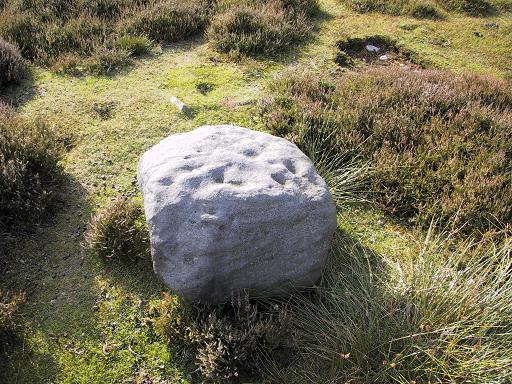
This was another carving found on one of the many forays of Mr Chappell and I when we were young, sometime in 1993. A short while after, Graeme wrote to Edward Vickerman to inform him of the find, which ended up in their rock art survey a decade later.
It’s another one of those simple designs: what seems like at least 5 cup-markings on a small rounded rock, with two of them linked together by a groove — possibly natural, possibly man-made — though there may in fact be seven or more cups etched onto its upper surface. It’s difficult to tell. It gives you the impression that its present position isn’t its original one and is suggested by Boughey & Vickerman (2003) to have been “moved from pipeline?” close by. It may even have been dug out and cast here, possibly once being a part of a cairn. In the Boughey & Vickerman survey they give its OS-coordinate as SE 17163 50527 – and describe it as a “medium-sized, free-standing rock of fine grit. Five cups, some perhaps natural.” When Richard Stroud and I visited the site, he found the GPS coordinate was SE 17162 50530; and we have to say that instead of describing it as a free-standing rock, it’s a movable stone (though it’d take a bit of effort), that may once have been part of a larger monument.
References:
Bennett, Paul & Chappell, Graeme, Personal Communication, 1993.
Boughey, Keith & Vickerman, E.A., Prehistoric Rock Art of the West Riding, WYAS: Wakefield 2003.
Not hard to locate. From Colne head up to Foulridge via the skipton Road and as you get to the middle of the town ask find the cenotaph just off the main road.
Archaeology & History
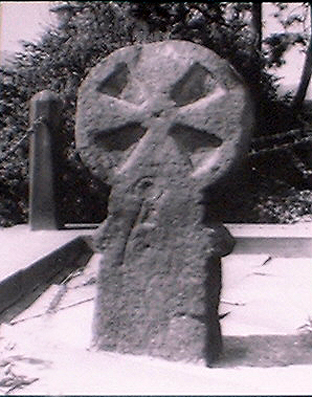
The Maiden or Tailor’s Cross, Foulridge
The Maiden or Tailor’s Cross has at least two old traditions attached to the site, which local historians think originate from the Civil War period. The first tells of a Royalist tailor who – sensibly – refused to make uniforms for Oliver Cromwell’s traitorous soldiers; but as a result, the poor tailor was shot by the troops and the remains of his body were placed over the old stone cross as a warning to his fellow workers. If you look closely on the cross you can see a crude carving of what looks like a pair of scissors or shears, and it is this carved symbol which has seemingly given birth to the legend of the tailor. There may, of course, be some truth in the story; but the carved shears is more likely an old Masonic carving – though quite who did it and when isn’t known.
The other legend is the one which apparently gave birth to the title of the Maiden’s Cross. It tells of a certain Margaret Burnard whose husband went into battle (on the side of the treacherous Cromwell), but who agreed before he set out that she should wait for him for to return by the side of the old cross; and this she did each and every day, waiting for her husband, Robert, to come back from the Civil War. But he was one of the many who died in the Battle of Marston Moor. However, Margaret refused to accept his death and returned to the cross each evening to their agreed meeting place. The story goes that Margaret herself herself was eventually killed by Royalist soldiers – and her body was buried at the cross where she had so often waited in vain.
It seems likely that this old cross originally replaced an old ‘heathen’ site in Foulridge. Several such spots were known here, though virtually nothing now remains. But notices of these sites will appear on TNA in the near future.
References:
Oldland, F., The Story of Foulridge, PHCL: Pendle 1990.
The place-name burwain is an early Old English word meaning “a cairn or tumulus”. It has variants such as borrans, borwen and borwans. In the developing survey by Parsons & Styles (2000), other linguistic examples are given, all of which point to the same thing, i.e., a prehistoric burial of one form or another. Also, in 19th century northern English dialect, Wright (1898) told that borrans is “a cairn, a heap of loose stones”—which is what used to exist hereby.
The fact that there is a place-name telling of its existence implies that it was a cairn of some size, but sadly all remains of it have long since gone. All that we’ve got left is the name of Burwains house on the early Ordnance Survey maps. Built on a hilltop rise, which is a common construction spot for such sites up and down the country, it’s possible that the cairn was destroyed when the Foulridge Lower Reservoir was built in 1793, with the mass of stone used in its construction (the reservoir also kept the name of Burwains lake for sometime).
References:
Clayton, John A., Valley of the Drawn Sword, Barrowford Press 2006.
Parsons, D.N. & Styles, T., Vocabulary of English Place-Names – volume 2, EPNS: Nottingham 2000.
Smith, A.H., English Place-Name Elements – volume 1, Cambridge University Press 1954.
Wright, Joseph, English Dialect Dictionary – volume 1, Henry Frowde: London 1898.
You’re a bit spoilt for choice in terms of how your reach this spot, high upon White Moor – which is south of Barnoldswick, west of Salterforth, northwest of Foulridge, north of Barrowford, or northeast of Blacko. Whichever route you end up taking, you’re going uphill onto the heights near Weets Hill – and find the old trackway which bisects White Moor and has the rather tell-tale name of Lister Well Road! It’s roughly halfway along the route, right by the trackside.
Archaeology & History
Lister Well, White Moor
History and folklore here have long been silent (though I aint checked the Annals of Barrowford, which may prove useful). A local land-owner told us that the original trough had been uprooted a few decades back when the gas- or electricity-board (he can’t remember which) did some work hereabouts and uprooted the stone trough into which the waters ran and, for sometime, caused the complete destruction of the supply. But its waters eventually re-emerged from the Earth, trickling into the grassy drainage line on the southern-edge of the track before going under the wall and down the moorland slope.
If you like a good walkabout with good views to behold, get y’self up here and have an amble. Tis a damn fine place, with a lot of forgotten history embedded in the landscape.
From Foulridge go west up the long windy road (B6251) till you hit the old crossroads near the top. Turn right and go on till you hit the modernised farmhouse on your right, where you’ll notice a modern upright stone in the entrance. You need to go back about 70 yards and you’ll see this old stone in the wall.
Archaeology & History
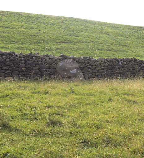
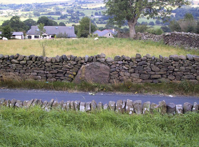
“Standing Stone Road’ stone!
Less than a mile northwest of Foulridge along the southern stretch of the Whitemoor Reservoir, on the northern outskirts of Colne, we find the intriguingly-named ‘Standing Stone Lane’ — which seems to indicate that at some time in the not-too-distant past, an old monolith could be found hereabouts. The old maps show the boundary line turning at right angles just near the crossroads, which is where I thought we might locate some remains of an old standing stone. But it wasn’t to be. Instead, we need to travel about 100 yards west along the single-track road, just below the reservoir — and there, in the walling, plain for all to see, is what may be the old standing stone which gave the road its name. I found this site in early July 2008, and although we can’t be 100% certain, it’s not too bad a good contender as the monolith which first gave the road its name. Does anyone know anymore about it?
More probably though (and this is what ‘feels’ right): the original stone which gave the road its name was much bigger than this little thing, but was probably destroyed when the reservoir here was constructed. How much d’ y’ wanna bet!?