To search for any sites in the northern counties of England (previously known as Brigantia), click on the list of relevant counties, below. Please note that not all these english counties were truly in Brigantia, but they came close to its southern edges; and as parts of them tickle the edges of the southern Pennines, I thought they should be included. Hope that’s OK with everyone!
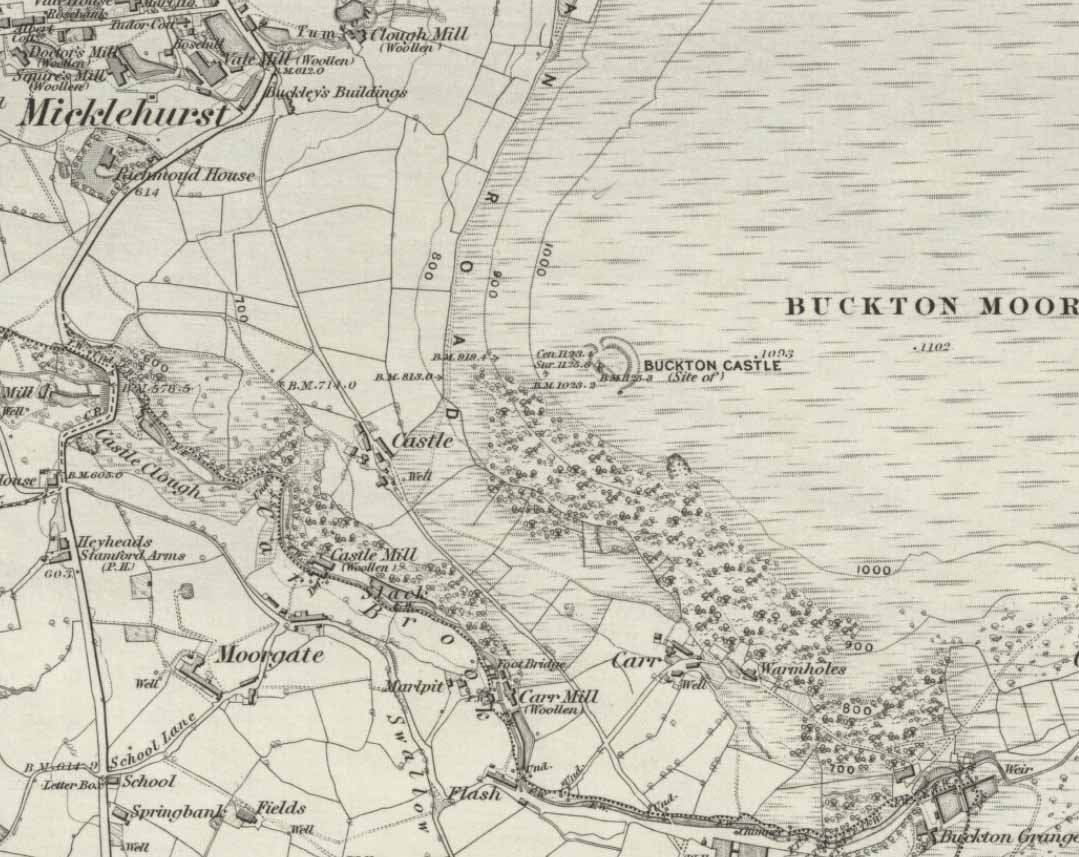
This giant site—deemed as Iron Age by some and medieval by others—is on the verge of complete destruction as the adjacent quarrying company cuts closer and further into the sides and top of the monument. Local people and archaeologists need to do something about this, or it will be lost forever as the Industrialists once again destroy more of our ancient heritage in order that they can feed their god of Money.
Folklore
Legend has always told that great treasure existed beneath the grounds of this Brigantian hillfort, found on the moor-edges to the east of Manchester. Long ago, one man came along to see if he could find the treasure, said to consist of a huge chest of gold. The man brought two horses and the ground within the fort was gradually cleared away until, to the man’s surprise, the legendary chest was revealed!
Attaching chains to it and the horses, the man shouted:
“Gee, whoa, whoo! Bonny, Buck and Bell,
I’ll have this chest o’ gowd, i’ spite o’ all t’ devils in hell!”
But barely had the words left his mouth and the chest began to move, when the devil himself appeared in the shape of a huge hen that breathed fire! This scared the horses so much that they bolted and snapped the chains, taking their master with them but leaving the treasure-chest still in the ground. To this day the chest still remains, hidden in the Earth.
References:
Winterbottom, Vera, The Devil in Lancashire, Cloister: Stockport 1962.
Cairn (destroyed): OS Grid Reference – NZ 6950 1886
Archaeology & History
Frank Elgee’s 1930 plan
Another old site that has sadly succumbed to that bollox called ‘progress’! It’s in the North Yorkshire region some halfwits have taken to calling Cleveland — but which a lotta local folk still correctly call Yorkshire. But that aside…
In an article by local students William Hornsby and Richard Stanton written in 1917, we find that this was just one of at least seven hillocks presumed to be barrows here — but all the others had gone even in their day. When Crawford (1980) came to survey the site in the late 1970s, he told that,
“this large barrow is now only visible as a low swell in an arable field… (but) the profile of the barrow is retained in the hedgeline that bisects it from north to south, but the whole of its eastern half has been obliteratd by the Brotton-Kilton road.”
Elgee’s 1930 photo of one of the carvingsE.T. Cowling’s drawing of one of the carvings
When Hornsby and Stanton checked the place out it measured 54 feet in diameter and had an extensive covering of small stones, like a large cairn, with a single grave at the centre, aligned north-south; and a tree-trunk coffin on the southwestern side. Of the stones which filled the central grave, eight of them were found to have cup-markings on them; whilst 16 stones covering the tree-trunk grave also possessed cup-markings. Roughly equidistant between the two burials was another stone found to be resting face-down on the original ground-level, and covered with 20 cups and 5 cup-and-rings! Awesome stuff!
G.M. Crawford’s (1980) description of the site was as follows:
“Howe Hill was excavated by Hornsby and Stanton in 1914; they discovered that the mound was made up with a clay floor, overlain by ‘a cairn 30 feet long and 3 feet high’ of diorite cobbles, capped by a layer of earth. Cut into the clay floor were two graves: the first was oriented north-south and measured 2m long by 0.9m wide at the old land surface and was 0.7m deep. The grave was filled with ‘medium sized stones’ with a ‘thin dark layer,’ thought to be an inhumation burial, on the floor; 8 of the stones bore cup-marks. The second grave, oriented northeast-southwest, was 2.5m long by 0.9m wide at the old ground surface, reducing to 1.8m long by 0.5m wide at its bottom, 1.3m below. This grave, which was filled with stones, also contained a tree-trunk coffin or oak, measuring 1.5m long… At the head (northeast) were found the unburnt skull fragments of a man laid on its right side. Unaccompanied cremations had been placed at both ends of the coffin. 16 cup-marked stones were among the infill of the grave.”
This was obviously a site of considerable importance and it’s a huge pity (if not a disgrace) that today no trace of the site remains.
References:
Cowling, Eric T., Rombald’s Way, William Walker: Otley 1946.
Crawford, G.M., Bronze Age Burial Mounds in Cleveland, Cleveland County Council 1990.
Elgee, Frank, Early Man in North-east Yorkshire, John Bellows: Gloucester 1930.
Hornsby, William & Stanton, Richard, “British Barrows near Brotton,” in Yorkshire Archaeology Journal, 24, 1917.
Smith, A.H., The Place-Names of the North Riding of Yorkshire, Cambridge University Press 1928.
From Kilburn village, take the north road up past the church for about 300 yards, bearing up the track on your left and walk up into the wooded hill a mile ahead of you. It’s in there!
Folklore
In this region there’s a teeming cluster of druid, fairy, devil and spook-lore, along with numerous prehistoric remains. Not sure this site has such an archaic pedigree, though the creation myth told of this rock (marked on the 1st edition OS-map as an antiquity) seems to imply as such. Our old devil disguised himself as a druid many moons ago in an attempt to gain favour with the old priests, but was discovered in his plans and so, in anger, flew out across the hills carrying a great stone with him which he dropped from the skies and it landed where the Hood Hill Stone still remains. Also in anger he jumped down and stood on the great rock, and in doing so left his footprint impressed upon the stone. (There’s the possibility this is an unrecognised cup-marking – having not been here I can’t say misself). Edmund Bogg (1906) also tells us that,
“The monk’s hood-like configuration of the crest is said to have originated its name. The busy tongue of tradition, however, says that the name commemorated Robin Hood who, with his merry men, affected the hill-fastnesses hereabouts; but the hill was named ‘Hode’ long, long before the famous Robin came this way at all.”
The same writer also told how,
“legend, too, has it that the happy valley just north of Hood Hill…was a secluded and sacred retreat of the druids, and at the introduction of christianity into these parts, a great assembly gathered to consider which of the two religions should in future be adopted.”
Yet another legend – and an old one, says Bogg – is “that when the dinner-bell rang at Osgodby Hall the stone rolled down for its repast, and regularly returned to the crest after the meal.”
It’s blatantly obvious that something of antiquity this way hides. The “enclosure” shown on the modern OS-maps here could do with being looked at little closer.
References:
Bogg, Edmund, Richmondshire and the Vale of Mowbray (volume 1), James Miles: Leeds 1906.
To find this, head for the line of old grouse-butts which run north-south, a few hundred yards west of the Askwith Moor Road. Just before y’ get to the one nearest the bottom of the line, frobble about a bit. If by any chance you end up at the Woman Stone carving, walk back up the slope until you’re on the level. Not far ahead of you are the upright stone remains of a grouse-butt. This carving is just a few yards away. You’ll find it.
This was another carving found on one of the many forays of Mr Chappell and I when we were young, sometime in 1993. A short while after, Graeme wrote to Edward Vickerman to inform him of the find, which ended up in their rock art survey a decade later.
It’s another one of those simple designs: what seems like at least 5 cup-markings on a small rounded rock, with two of them linked together by a groove — possibly natural, possibly man-made — though there may in fact be seven or more cups etched onto its upper surface. It’s difficult to tell. It gives you the impression that its present position isn’t its original one and is suggested by Boughey & Vickerman (2003) to have been “moved from pipeline?” close by. It may even have been dug out and cast here, possibly once being a part of a cairn. In the Boughey & Vickerman survey they give its OS-coordinate as SE 17163 50527 – and describe it as a “medium-sized, free-standing rock of fine grit. Five cups, some perhaps natural.” When Richard Stroud and I visited the site, he found the GPS coordinate was SE 17162 50530; and we have to say that instead of describing it as a free-standing rock, it’s a movable stone (though it’d take a bit of effort), that may once have been part of a larger monument.
References:
Bennett, Paul & Chappell, Graeme, Personal Communication, 1993.
Boughey, Keith & Vickerman, E.A., Prehistoric Rock Art of the West Riding, WYAS: Wakefield 2003.
Not hard to locate. From Colne head up to Foulridge via the skipton Road and as you get to the middle of the town ask find the cenotaph just off the main road.
Archaeology & History
The Maiden or Tailor’s Cross, Foulridge
The Maiden or Tailor’s Cross has at least two old traditions attached to the site, which local historians think originate from the Civil War period. The first tells of a Royalist tailor who – sensibly – refused to make uniforms for Oliver Cromwell’s traitorous soldiers; but as a result, the poor tailor was shot by the troops and the remains of his body were placed over the old stone cross as a warning to his fellow workers. If you look closely on the cross you can see a crude carving of what looks like a pair of scissors or shears, and it is this carved symbol which has seemingly given birth to the legend of the tailor. There may, of course, be some truth in the story; but the carved shears is more likely an old Masonic carving – though quite who did it and when isn’t known.
The other legend is the one which apparently gave birth to the title of the Maiden’s Cross. It tells of a certain Margaret Burnard whose husband went into battle (on the side of the treacherous Cromwell), but who agreed before he set out that she should wait for him for to return by the side of the old cross; and this she did each and every day, waiting for her husband, Robert, to come back from the Civil War. But he was one of the many who died in the Battle of Marston Moor. However, Margaret refused to accept his death and returned to the cross each evening to their agreed meeting place. The story goes that Margaret herself herself was eventually killed by Royalist soldiers – and her body was buried at the cross where she had so often waited in vain.
It seems likely that this old cross originally replaced an old ‘heathen’ site in Foulridge. Several such spots were known here, though virtually nothing now remains. But notices of these sites will appear on TNA in the near future.
References:
Oldland, F., The Story of Foulridge, PHCL: Pendle 1990.
The place-name burwain is an early Old English word meaning “a cairn or tumulus”. It has variants such as borrans, borwen and borwans. In the developing survey by Parsons & Styles (2000), other linguistic examples are given, all of which point to the same thing, i.e., a prehistoric burial of one form or another. Also, in 19th century northern English dialect, Wright (1898) told that borrans is “a cairn, a heap of loose stones”—which is what used to exist hereby.
The fact that there is a place-name telling of its existence implies that it was a cairn of some size, but sadly all remains of it have long since gone. All that we’ve got left is the name of Burwains house on the early Ordnance Survey maps. Built on a hilltop rise, which is a common construction spot for such sites up and down the country, it’s possible that the cairn was destroyed when the Foulridge Lower Reservoir was built in 1793, with the mass of stone used in its construction (the reservoir also kept the name of Burwains lake for sometime).
References:
Clayton, John A., Valley of the Drawn Sword, Barrowford Press 2006.
Parsons, D.N. & Styles, T., Vocabulary of English Place-Names – volume 2, EPNS: Nottingham 2000.
Smith, A.H., English Place-Name Elements – volume 1, Cambridge University Press 1954.
Wright, Joseph, English Dialect Dictionary – volume 1, Henry Frowde: London 1898.
You’re a bit spoilt for choice in terms of how your reach this spot, high upon White Moor – which is south of Barnoldswick, west of Salterforth, northwest of Foulridge, north of Barrowford, or northeast of Blacko. Whichever route you end up taking, you’re going uphill onto the heights near Weets Hill – and find the old trackway which bisects White Moor and has the rather tell-tale name of Lister Well Road! It’s roughly halfway along the route, right by the trackside.
Archaeology & History
Lister Well, White Moor
History and folklore here have long been silent (though I aint checked the Annals of Barrowford, which may prove useful). A local land-owner told us that the original trough had been uprooted a few decades back when the gas- or electricity-board (he can’t remember which) did some work hereabouts and uprooted the stone trough into which the waters ran and, for sometime, caused the complete destruction of the supply. But its waters eventually re-emerged from the Earth, trickling into the grassy drainage line on the southern-edge of the track before going under the wall and down the moorland slope.
If you like a good walkabout with good views to behold, get y’self up here and have an amble. Tis a damn fine place, with a lot of forgotten history embedded in the landscape.
From Foulridge go west up the long windy road (B6251) till you hit the old crossroads near the top. Turn right and go on till you hit the modernised farmhouse on your right, where you’ll notice a modern upright stone in the entrance. You need to go back about 70 yards and you’ll see this old stone in the wall.
Archaeology & History
“Standing Stone Road’ stone!
Less than a mile northwest of Foulridge along the southern stretch of the Whitemoor Reservoir, on the northern outskirts of Colne, we find the intriguingly-named ‘Standing Stone Lane’ — which seems to indicate that at some time in the not-too-distant past, an old monolith could be found hereabouts. The old maps show the boundary line turning at right angles just near the crossroads, which is where I thought we might locate some remains of an old standing stone. But it wasn’t to be. Instead, we need to travel about 100 yards west along the single-track road, just below the reservoir — and there, in the walling, plain for all to see, is what may be the old standing stone which gave the road its name. I found this site in early July 2008, and although we can’t be 100% certain, it’s not too bad a good contender as the monolith which first gave the road its name. Does anyone know anymore about it?
More probably though (and this is what ‘feels’ right): the original stone which gave the road its name was much bigger than this little thing, but was probably destroyed when the reservoir here was constructed. How much d’ y’ wanna bet!?
Aerial photo of the cursus (courtesy Antiquity journal)
Once to be seen running from the edges of Weston Grange northeast by the canal around Acrelane Bridge, this important mile-long neolithic monument beyond the southern outskirts of Derby has been damaged along much of its length due to the carefree approach of modern industrialists. Found just over 6 miles east of the Potlock or Twyford Cursus, this site was described by J.K. St. Joseph (1964; 1966) in Antiquity journal following an aerial survey of the region on August 7, 1962 — from whence the photograph here was taken, which shows the dead straight monument stretching southwest across the fields. The photo also gives a good idea as to how massive this prehistoric monument actually was! In Mr St. Joseph’s second short essay on this aligned site he told:
Aston Cursus (from Antiquity, 1966)
“The cursus at Aston upon Trent lies at a distance of half a mile from the left bank of the Trent, on gravel overlying New Red Sandstone, at a height of about 120ft O.D., some five miles southeast of Derby. No traces are visible on the surface, but photographs taken over the last few years enable the side-ditches of the cursus to be traced for a length of some 4500ft on a north-east to south-west alignment across six fields: the ditches are parallel and some 325ft apart. Though the entire length has not yet been recorded, the south-west end must lie near the farm of Weston Grange, while the north-east end is a little to the east of the road from Aston upon Trent to Shardlow. The north-western side ditch is interrupted towards the south-west end by two narrow gaps, 500ft apart.
“…Two ring-ditches lying within the cursus perhaps mark ploughed-out barrows. In diameter they measure some 120ft; one of them is defined by a double ditch. There are at least three small ring-ditches, of which one is intersected by the north-west ditch of the cursus. Five small square enclosures lying within the cursus towards its north-east end are less easy to explain. They are not unlike the square ditched enclosures recorded on the Yorkshire Wolds, and there identified as square barrows. About halfway along the length of the cursus a single ditch encloses an irregular area interrupted at two points for an entrance. One end of this area and the north-west ditch of the cursus overlap. Thereabouts, too, the cursus is crossed by elements of a system of linear ditches, which seem to be agricultural divisions of a kind often interpreted in the Middle Thames valley as of Iron Age or Roman date. A similar date is likely enough here, but the question is best left open until some examples have been tested by excavation. Lastly, the “pit-alignment” which extends for some distance towards the (River) Trent is seen to cross the whole width of the cursus, as does a double-line of pits nearer the north-east end…”
More than forty years later and the site is described on English Heritage’s website – at www.pastscape.org.uk, where a few additional aspects of the site are described:
“A cursus monument at Aston Upon Trent, orientated roughly southwest-northeast and located on the gravels of the trent valley, circa 1 kilometre northwest of the present course of the river. The cursus appears to be a regular rectangle, the long sides parallel and circa 100 metres apart. The southwest terminal is straight, and meets both sides at right angles. The northeast terminal has not been recorded as a cropmark, but may well have lain in an area which has been quarried away. If so, the cursus would have originally been a little over 1.5 kilometres in length.
“The cursus ditch was sectioned in the mid-1960s by D. Reaney, though no finds were made. The recorded stratigraphy suggested an internal bank. Further small-scale excavation occurred in 1986 at a point where the cursus ditch appeared to intersect with a ring ditch (SK 42 NW 59), towards the cursus’ south-western end. The cursus ditch appeared to run into and cut the ring ditch, and was therefore later in date. The slightness of the ring ditch and the nature of its fill suggests that there is unlikely to have been a mound of any substantial nature in its interior. Finds were few, and none from primary contexts. They comprised a thumb nail scraper, another worked flint, and a few sherds of pottery, identifiable as Grimston and Beaker ware.
“Adjacent to the ring ditch is another, not excavated, but also contained within the cursus. In 1995, an existing field drain alongside Acre Lane (in the area circa SK 4244 2968) was enlarged as part of work associated with construction of the Derby Southern Bypass.
“The sides of the drain were recorded archaeologically. The western cursus ditch was not present, suggesting the existence of a gap or causeway. The eastern cursus ditch, though not visible on air photographs at this point, was located. Pollen samples were collected, and a fragment of waterlogged wood is to be used for radiocarbon dating.”
The site has since been found to be at least 1700 metres (5610 yards) long, with its northeastern end, or terminus, still undiscovered. It was described by Loveday (2006) as being, “overlain at its mid-point by a tangle of fields and trackways of presumed Iron Age date.” One prehistoric track crosses the cursus at a right-angle then turns 90° just as it crosses the dead straight alignment, running parallel with the cursus ditch for some 300 yards. (see illustration below)
References:
Gibson, A.M. & Loveday, Roy, ‘Excavations at the Cursus Monument on Aston-upon-Trent, Derbyshire,’ in A.M. Gibson’s Midlands Prehistory, BAR 204: Oxford 1989.
Loveday, Roy, Inscribed Across the Landscape, Tempus: Stroud 2006.
St. Joseph, J.K., “Air Reconnaissance: Recent Results, 6,” in Antiquity, volume XL, no.157, March 1966.
Aston Cursus, with overlying Iron Age tracks & fields (after Loveday 2003)
From Ilkley, head up the road towards White Wells and keep going along the road. Shortly before the road becomes a dirt-track, just over a small stone bridge with gorse all around, there’s a noticeable footpath that runs west onto the moors, going roughly parallel to the wealthy houses by the moorside. Keep going along this footpath and you’ll hit the recently unneeded modern creation of a large sandy trackway (and excessive litter that it’s created) that takes you straight to the curious railings stuck upon some rocks a quarter-mile away. That’s where you’re going!
Archaeology & History
This famous carving was first described as a ‘swastika’ by a Mr J. Thornton Dale around 1880 – and the name seemed to catch on damn quick! The stone had become established with this title at the end of that decade, and seemed immortalized with the name when J. Horsfall Turner wrote about it in the very popular history book he co-authored with the reverend Collyer in Ilkley Ancient and Modern. (1885) By then, comparisons had already been drawn with the acknowledged swastika symbol in Tossene, Sweden, and by the time Harry Speight described it in his colossal Upper Wharfedale (1900), other near-identical European swastika carvings had been found in Valcamonica, northern Italy. (though these lacked the ‘tail’ found on Ilkley’s carving)
J.R. Allen’s drawing of Swastika StoneEric Cowling’s sketch of the carving
Earlier images of the swastika symbol can be found in most continents, but the earliest known example appears to be the paleolithic swastika carvings from the Ukraine, etched on pieces of ivory and dating from between 18,000-15,000 BC. Some swastikas have been found carved on mammoth tusks!
Invariably in modern history it is its mythic association of the swastika to certain political imbeciles which troubles many people, but this needs to be set into a much more ancient historical context. The symbol ostensibly relates to sacred notions of the cosmos in all the non-literate cultures where it appears. Numerous surveys by comparative religious scholars isolated the nature of the design many years ago. The Leeds Buddhist, Steve Hart, said that Ilkley’s Swastika Stone:
“to a Buddhist should be a sonorous gatha (a sutra or verse), a plenitude of transcendental boddhisattvic vision. The swirling wheel of the four arms suggests the four realms as experienced by Jains, upanishadic sages and ancient Buddists. They ARE samsara. The samsara is resolved into the nirvana at the hub. The four realms are the human realm, god realm, hell realm and the nature realm. There are no clear delineated demarcations between these realms. All interpenetrate.”
(Images of the popularised ‘modern’ swastika – a huge misnomer – can be found on several church bells in Yorkshire, where they were used as charms to protect against lightning, following in the mythic fashion of Thor. These swastikas date from the 15th century.)
Evan Hadingham’s rubbing of the carving
I first saw this carving when I was 10-years old and it had one helluvan effect on me! I stood and stared at it (or rather gazed, without thought…) for some length of time, knowing that I’d seen this somewhere before* and that it had some considerable importance – though about what, I knew not! The cups in the design align north-south and east-west. The northern line points directly at Simon’s Seat on the northern skyline. The eastern axis points directly at Almscliffe Crag, above which the equinox sun seems to rise from here.
For the real alignment fanatics, check out the alignment from Twelve Apostles to here: on the date of the last major lunar standstill (occurrent every 18.6 years), the moon set over the cairn at Lanshaw Lad. It wasn’t until I got home and checked the extension of this moonset line, that I realised if you follow it further along the course, you hit the Swastika Stone bang on! Though this is probably just a coincidence (we do have hundreds of cup-and-rings on these moors, so it’s bound to hit one or more of them).
The Swastika in 1930, with info-board
In this Swastika Stone, the curious single ‘outlying’ cup-and-ring at the edge of the four spiralling arms is very probably the point from which the four-arms originated and not the other way round. In traditional cultures and early cosmogenic patterns the world over, the cosmos itself emerged from the ’round’, the singular, the point, or uroboros — and this is what this Swastika Stone appears to represent here: the cosmos emerging from the singularity, giving birth to the world and the four cardinal points. Such an element is a simple one and is found in Creation myths the world over. (For those of you who aint into using psychedelics at sites, a good overview of this idea is in Erich Neumann’s Origins & History of Consciousness [although there’s no reference to this symbol] and which should be read by anyone pretending an interest in the nature of the archaic mind. It’s a good work on the psychology of the Dreamtime.)
As some local Ilkley folk are probably aware, a copy of the Swastika Stone carving was executed in the latter-half of the 19th century, probably by a local chap called Ambrose Collins, not far from the original swastika at the edge of the woodland. Some images and a brief history of this copied swastika and associated cup-markings will be published in due course on the Rombalds Moor Project website.
Other important cup-and-ring petroglyphs that are worth visiting on the moor with unique carved symbols in them include the Hanging Stones, the Idol Stone, Haystack Rock, Badger Stone and many many more.
Note:
A fella who used the pseudonym of ‘Pad’ suggests that the carving is only a few centuries old, and compares it to other much more recent etchings on these moors, where the erosion has been of no greater or lesser force. The suggestion has been made about other carvings on these moors and whilst I have an open mind about this, if this is the case, we would have to relate the same reasoning to countless other carving on these hills. In which case, a great deal of cup-and-ring art would have to be redesignated as medieval in nature.
References:
Bennett, Paul, The Old Stones of Elmet, Capall Bann: Milverton 2001.
Boughey, Keith & Vickerman, E.A., Prehistoric Rock Art of the West Riding, WYAS: Wakefield 2003.
Collyer, Robert & Turner, J. Horsfall, Ilkley, Ancient and Modern, William Walker: Otley 1885.
Cowling, Eric T., Rombald’s Way, William Walker: Otley 1946.
Hadingham, Evan, Ancient Carvings in Britain, Garnstone: London 1974.
Hedges, John, The Carved Rocks on Rombalds Moor, WYMCC: Wakefield 1986.
Pennick, Nigel, The Swastika, Bar Hill: Cambridge 1980.
Speight, Harry, Upper Wharfedale, Elliott Stock: London 1900.
Wilson, Thomas, The Swastika – The Earliest Known Symbol and its Migrations, Smithsonian: Washington 1896.
* although I’d never seen the carving before, I had of course seen its archetypal manifestation in the shapes in Nature: spiral galazies, polar rotation (I was a budding astronomer as a kid!), hair growth from the crown, petals, swirling clouds, etc, etc. The Swastika, as we know, is representative of the creative spark itself: the life-essence, emerging from the centre and manifesting itself in the four worlds, which are its emergent arms.
Links:
Reclaim the Swastika – A fine website which is into doing just what it says on the tin!
")
")
")


