Stone Circle (destroyed): OS Grid Reference – SM 8615 1428
Archaeology & History
Described in context with an extant standing stone 100 yards to the north, this stone circle seems to have been destroyed in the latter half of the 19th century. It was described in the Royal Commission’s huge Pembrokeshire (1925) survey, after they had visited the site and viewed the remains. They told us:
“On the side of the road immediately opposite to Cliff Cottage, and constituting part of the garden walls of Upper Lodge, are numerous boulders which formed a well-defined stone circle. A few years ago they were moved, dressed, and used for walling. The entrance to the circle is said to have faced north-east. The southern portion was still visible about the year 1896.”
As far as I’m aware, local people report that a couple of the stones are still visible in the overgrown walling. Students working for the Welsh Coflein database allege that the remaining stones “are of doubtful antiquity.” Unless they have some substantial evidence to validate this statement (none is given) their remarks should be taken with a pinch of salt.
References:
Royal Commission Ancient & Historical Monuments, Wales, An Inventory of the Ancient Monuments in Wales & Monmouthshire: VII – County of Pembroke, HMSO: London 1925.
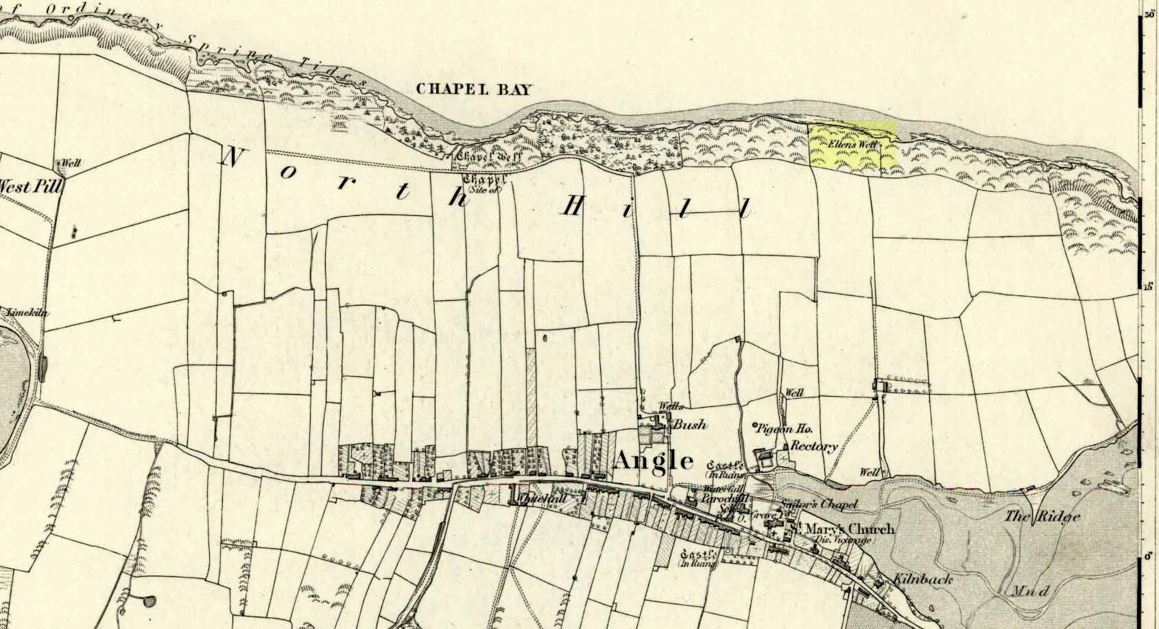
Very little seems to be known about this apparently lost site, deemed to be an authentic holy well in Francis Jones’ (1954) fine survey: the ‘Ellen’ in question here being the legendary St Helen. It was highlighted on the first OS-map of the area in 1869 and subsequently included in the Royal Commission’s huge Pembrokeshire (1925) tome, but when they came to visit the site they reported that “it could not be traced, nor any information obtained about it.” Has it truly fallen back to Earth, or do any local historians and antiquarians know where it is…?
References:
Jones, Francis, The Holy Wells of Wales, University of Wales 1954.
Royal Commission Ancient & Historical Monuments, Wales, An Inventory of the Ancient Monuments in Wales & Monmouthshire: VII – County of Pembroke, HMSO: London 1925.
Sacred Well (destroyed): OS Grid Reference – SE 1589 3132
Archaeology & History
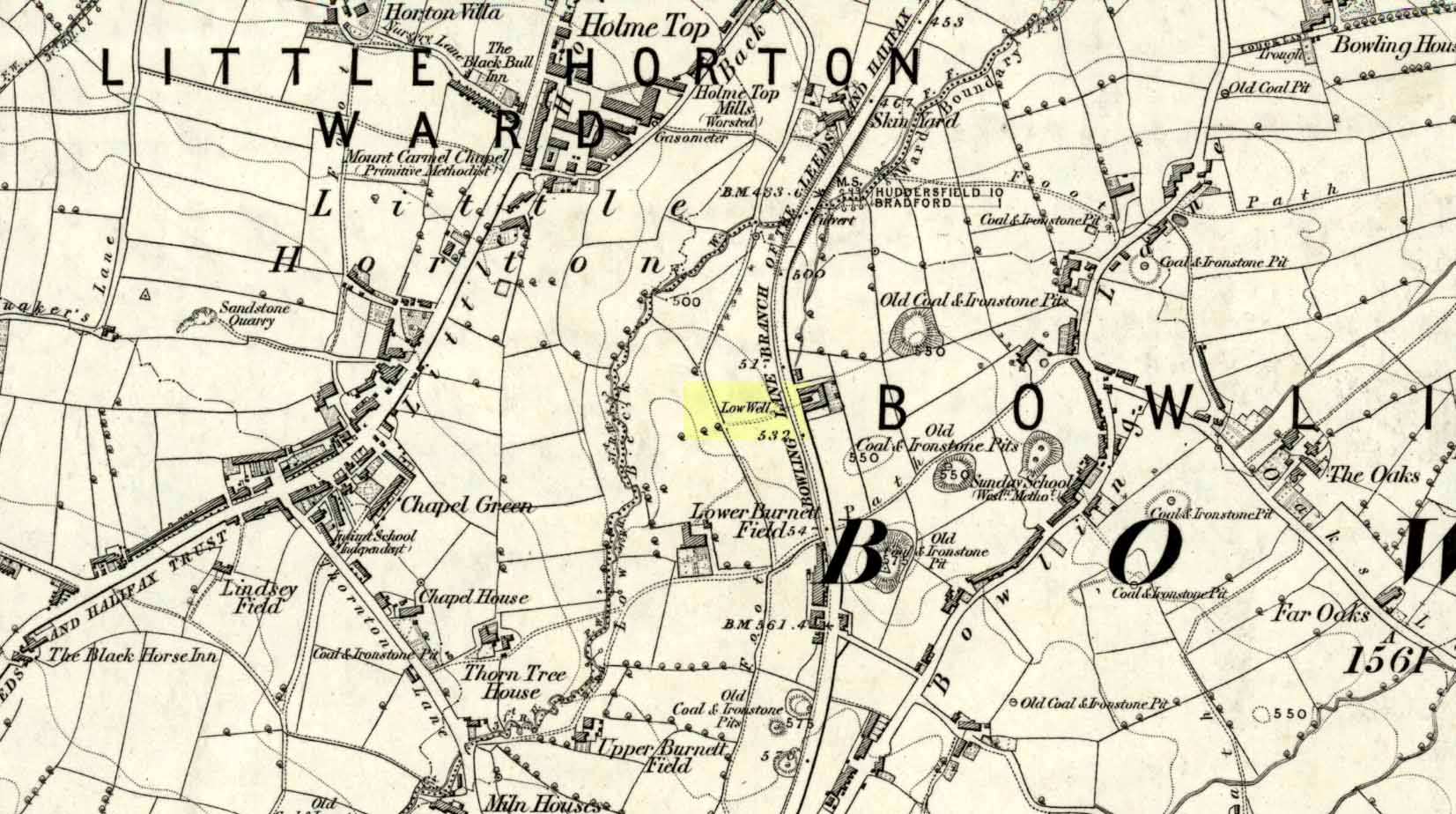
Low Well on 1852 map
Along the now-lost Low Well Road between Little Horton and West Bowling, could once be found this innocuous-sounding water source. Shown on the 1st OS-map of the area in 1852, the site was deemed to be little other than a ‘public well’. At the end of the 19th century, a small well-house was built over the waters; and the years following that saw its complete demise. Its name you would think relates to a position in the land, but the dialect word low, or lowe can mean “a flame, blaze, light, glow”, it can also refer to a prehistoric tomb. However in this case it most likely derives from “a pond or standing pool”.
…And if some of you wonder why I have given this so-called Public Well the provenance of being a “sacred well”, please keep reading…
Folklore
Although it was deemed a simple ‘public well’ by historians and the public water authority, local folk knew there was much more to it than that! In the Bradford area, this innocuously-named Well is the most promiscuously supernatural of all water sources, with a hidden history of magickians, ghosts and black dogs haunting its once ancient flow. It was a site remembered as having oracular powers, where local people used it in scrying the future. For such powers to work here, one had to gaze into the waters as they stilled at 6 o’ clock in the morning – a common time used by ritual magickians for the invocations of spirits.
The Bradford historian William Scrotum (1889) told us that in the 1860s, local people reported that the phantom black dog—or Bharguest as it was known—with its glowing red eyes, was seen coming out of the well after dark and scaring people half out of their wits. Very soon people would not even venture out after dark for fear of encountering this great harbinger of Death. Several years passed before local people called upon the abilities of a ritual magickian in the hope that he could lay the ghostly hound and bring peace and stability back to the hearts and minds of those living hereabouts. Eventually, after much work, the magickian exorcised the waters and cast the black dog back into the depths of the Earth from whence it had come and, to this day, sightings of the spectral hound have stopped.
Water sources that possess ingredients of hauntings, magic and oracular properties are universally ascribed as ‘sacred’ in one way or the other. In pre-industrial times I have little doubt that, amongst the animistic pantheon of local Bradfordians, this was no exception.
References:
Scruton, William, Pen and Pencil Pictures of Old Bradford, Thomas Brear: Bradford 1889.
Wright, Joseph, The English Dialect Dictionary – volume 3, Henry Frowde: London 1902.
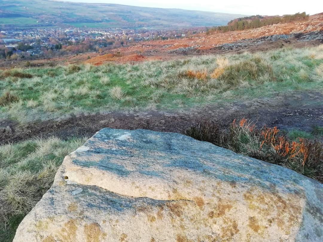
From Ilkley, go up to White Wells (ask a local if y’ get stuck) and walk round the back of the building. Walk to the trees and then follow the footpath up onto the moors; but after 70 yards a small footpath on your right goes up the slope. Take this and after about 90 yards it veers round to your left, following the contours up towards the copse of trees. Another 100 yards up it meets with another path and once here, just yards in front of you, right by the side of the footpath, is the stone in question.
Archaeology & History
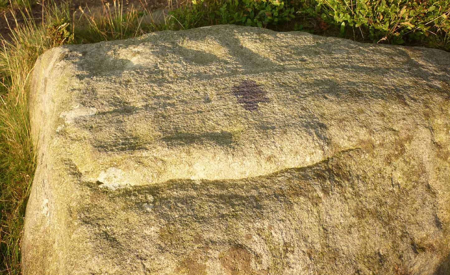
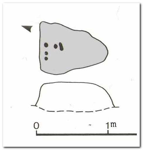
First described in John Hedges (1986) survey, this simple cup-marked stone typifies many petroglyphs on these moors: a barely visible design much eroded by centuries of wind and water, with markings perhaps only of interest to the devoted student and explorer. But at least it’s a good place to sit, rest and watch the valley below.
Looking down at the cupsHedges 1986 sketch
This old fella looks to have only five cupmarks on its supper surface, one of which is elongated, as shown in Hedge’s drawing. However, when he saw this, he thought the elongated ‘cup’ consisted of three of them in a line, all linked up. He saw a “medium sized smooth grit rock standing in grass, its surface triangular in shape, with flat top sloping slightly N to S. Three cups connected by a groove, c. four other cups, all shallow and worn.”
This description was echoed in Boughey & Vickerman’s survey (2003), where they thought that the “triangular top surface has about seven worn cups, three connected by a short groove.” But if the light isn’t quite right, this can be very difficult to see.
References:
Boughey, Keith & Vickerman, E.A., Prehistoric Rock Art of the West Riding, WYAS: Wakefield 2003.
Hedges, John (ed.), The Carved Rocks on Rombalds Moor, WYMCC: Wakefield 1986.
Healing Well (lost): OS Grid Reference – NS 910 790
Also Known as:
Tammy Milns Well
Archaeology & History
This all-but-forgotten site situated somewhere on the north side of Lauriston was mentioned in Falkirk’s Notes & Queries (1906) journal, but its whereabouts is somewhat of a mystery (to me at least!). In a series of question and answers about the site, the editor of the journal, James Love, told us:
“Mr Charles Brown, factor to the Marquis of Zetland, kindly informs us that on a late occasion there passed through his hands a copy of a feu contract by the Right Honorable Francis Lord Napier in favour of Alexander Cowie, brewer, at New Merchiston (now Laurieston), of a piece of ground lying to the north of Mary Street. This is dated 7 August, 1762 and contains the following clause: ‘Providing also that the said Alexr Cowie and his foresaid have the Liberty of the water of Tammy Milns Well in common with the said Lord Napier’s other vassals ay New Merchiston.'”
The well was mentioned again in 1781 with similar historical information. As to the name of the well, Mr Love wrote,
“it would appear, from the circumstance, that an old infirm man belonging to the village, called Thomas Mills or Milns, used to sit with his wooden cup at the spring which flowed from the face of the hill, over which the present structure now stands, and served out to the weary passers-by the cooling and refreshing draught for any small pittance they in their generosity might think proper to give him. After the lands of Lauriston passed into the hands of Sir Laurence Dundas, he took the advantage of such a copious supply of what then was pure water, and built the present reservoir over the spring, and had it conveyed to Kerse House by means of leaden pipes.”
But he fails to tell us what “the present structure” was that covered the well, nor the whereabouts of the “reservoir over the spring”; and as there’s no such feature on any of the Ordnance Survey maps at the time he wrote his article, nor beforehand, I remain puzzled as to its exact position. This situation isn’t helped by the earlier description, which said it was found on “a piece of ground lying to the north of Mary Street”. There are two wells literlly on the other side of Mary Street, but Kerse House meanwhile—whose water supply came from the well—is about 1½ miles to the north! All in all there are more questions than answers here. Added to this, in John Reid’s (2009) magnum opus on local place-names, the site is mentioned, albeit in passing, where he gives us the vague grid-reference of just NS 91 79, but this may just be educated guesswork on his part. It would be good to know exactly where it was…
References:
Love, James (ed.), “Tammy Mills (or Milns) Well, Laurieston”, in Local Antiquarian Notes & Queries, Falkirk – volume 1, 1906.
Reid, John, The Place-Names of Falkirk and East Stirlingshire, Falkirk Local History Society 2009.
Cup-and-Ring Stone: OS Grid Reference – NS 8551 8819
Archaeology & History
Looking down on C-7c
Near the northwestern end of the small geological ridge that runs to the west of Castleton farmhouse, close to an awesome nine-ringed carving, we find this more simplified triple-ringed petroglyph. And although the carving is easy enough to describe, its labelling (as ‘Castleton 7c’) is rather troublesome. As with other carvings in this locale, the name of the stone is based on a survey done by Maarten van Hoek in the mid-1990s. But van Hoek’s sketch of Castleton 7c and the one shown in our photos, whilst very similar, possess attributes that aren’t on van Hoek’s drawing. Now this isn’t too odd, as many petroglyphs look different when lighting conditions change; to the point where some features you can see one day are almost invisible the next. But this carving has attributes that are very difficult to miss – and van Hoek’s detailing tended to be good. But, all this aside: until we can verify with certainty one way or the other and despite my suspicions that this isn’t what van Hoek described, I’m still entering this carving as Castleton 7c. So – now that bit’s out of the way…!
When we visited the site two years ago the day was dark and overcast, so we didn’t really have good conditions for seeing any faint carvings. But this wasn’t faint, thankfully. It was completely buried beneath soil and gorse bushes, but thankfully Paul Hornby managed to unearth the one you can see in the photos. If it is the Castleton 7c petroglyph, it was rediscovered by van Hoek on one of his ventures here in 1985.
Carving showing wavy lines on right…and from another angle
When we visited the site we only managed to uncover a small section of the stone, as the roots of the surrounding gorse prevented us from seeing more. (it’s tough stuff unless you’ve got the right gardening equipment!) The section we uncovered consisted of a cup-and-triple-ring. This is consistent with van Hoek’s sketch and description; but we also found there were two very notable ‘arcs’ on the outer edge of the rings—nearly opposite each other—as if another, fourth ring had been started. You can’t really miss these elements – and even in the poor lighting conditions we had, these outer arcs are very evident on a number of photos – especially when they are expanded to full-scale. However, as I mentioned, we were unable to uncover all the rock; but when van Hoek was here there was far less herbage. What he saw on this carving was as follows:
“Deturfing part of this ridge revealed a fine cup with three rings with a broadly pecked tail; one solo cup; one large oval ring with small central cup; and a faint cup with two rings, the outer one incomplete. The rock slopes 12º ENE.”
Crap drawing done in crap lightingvan Hoek’s 1996 sketch
The “broadly pecked tail” he mentions is also not really clear in any of the 60 photos we took. There is a faint line that runs through the three rings, into the central cup and out the other side: a single curving line no less. It’s certainly visible, but it’s far from broad. But there are a number of other lines coming out of the rings. These maybe just natural scratch marks, or even scratches acquired from farming activity. It’s difficult to say. In the poor light that we had, there as looked to be a single cupmark a few inches away from the rings, but this isn’t consistent with the position of the cupmark on van Hoek’s sketch.
There’s a simple solution to all this: we need to revisit the site and expose more of the rock. At least that will tell us once and for all whether this is the same as van Hoek’s stone, or whether we’ve found yet another new carving. Watch this space, as they say! 😉
References:
van Hoek, Martin A.M., “Prehistoric Rock Art around Castleton Farm, Airth, Central Scotland,” in Forth Naturalist & Historian, volume 19, 1996.
Follow the directions to reach the faint but impressive Allt a’ Choire Chireinich (04) petroglyph. Standing here, you’ll notice the large boulder that looks as if it’s fallen down the slope immediately to your left. You can’t really miss it.
Archaeology & History
Beneath the gorgeous excess of ancient lichens you can make out at least three cup-marks on the south-facing sloping rock-face in the top-half of the boulder. There may be some other faint cups on here, but due to the lichens they are very difficult to see, so I’m erring on the side of caution regarding their veracity. This is another one of those carvings likely to be interest only to the most ardent petroglyphic nuts amongst you.
Follow the directions to reach the faint but impressive Allt a’ Choire Chireinich (04) petroglyph. Standing here, look straight down at the dried-up burn barely ten feet below you, where you’ll see a small sloping rock. That’s it!
Archaeology & History
Nothing much to see here apart from a single shallow cup-marking. Most likely of interest only to the most ardent petroglyphic explorer, but worth looking at when you’re visiting the more impressive carvings nearby.
Holy Well (destroyed): OS Grid Reference – T 2481 8173
Archaeology & History
Highlighted on the 1838 OS-map, Grogan and Kilfeather (1997) report that there are “no visible remains” to be seen of this holy well. The cult of St Patrick is still celebrated in Ireland every year on 17 March.
References:
Grogan, Eion & Kilfeather, Annaba, Archaeological Inventory of County Wicklow, Stationery Office: Dublin 1997.
Lynch, Geraldine, “The Holy Wells of County Wicklow,” in Wicklow History and Society (edited by K. Hannigan & W. Noland), Dublin 1994.
Petrifying wells are found across the British Isles and would be deemed as being medicinal, or curative at the very least. In Jeremy Harte’s (2008) massive study, he infers that some of them will have been regarded as sacred or ‘holy’. This makes sense. The water’s ability to calcify objects (turn them to stone) would be seen as a very strange effect indeed! Yet despite this Eskdale example being shown on the first OS-map in 1853, its history seems to have been forgotten. Back then, you could find it on the east side of the Murl Slack Beck, nearly a mile north of Grosmont village. I highlight the site in the hope that someone may be able to unearth something about its past and/or its present condition.
References:
Harte, Jeremy, English Holy Wells – volume 1, Heart of Albion Press: Marlborough 2008.