Pretty easy to get to. Go south through the village for a half-mile until you reach the hall by the fire station, sat back on the left-hadn side of the road a few hundred yards past Loch a’ Mhuillinn. Stop here and walk up the slope behind the hall for a hundred yards or so. Walk about!
Archaeology & History
The OS-coordinate here is a loose one. It centres on the notable hillock of Torr Mor, around which are a number of hut circles (at NG 7097 4293; NG 7139 4303; NG 7087 4309; NG 7088 4310 and NG 7090 4320) which are each in a relatively good condition and are thought to date from at least the Iron Age. When I visited them, the bracken had encroached on all but one of them (the last in the list above), which was about 30 feet across.
North of here are several curious-looking heaps of stones which need closer examination when the vegetation has died away. At first glance they would seem to be cairns, i.e. tombs. No such prehistoric graveyard has been found anywhere on the peninsula as yet – but considering the existence of the settlements in the area at Sand, you’d think there’d be one somewhere!
The Cambridge biologist J. Havelock Fidler described finding three standing stones in the gorgeous little remote hamlet of Toscaig in his book Ley Lines (1983), which neither the Applecross Local History Society, myself, nor anyone else has been able to locate (the OS grid reference cited above is simply an approximation of their locality). In an updated version of his work, Mr Fidler seems to indicate they can be found a short distance south-east of the village, at the end of an alignment which is supposed to start at Fearnmore (NG 724 605), at the northern edge of the peninsula. If they exist, could anyone perhaps enlighten us as to their whereabouts…?
References:
Fidler, J. Havelock, Ley Lines – Their Nature and Property, Aquarian: Wellingborough 1983.
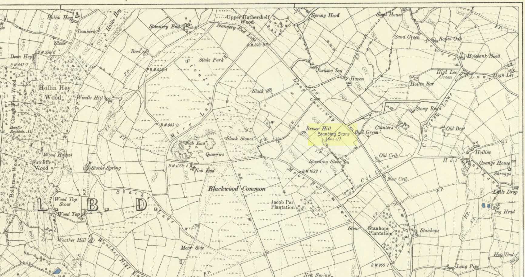
Standing Stone (destroyed): OS Grid Reference – SE 024 244
Archaeology & History
Standing stone on 1894 map
Also known as the Field House Standing Stone, this monolith seems to have gone. It was first described in local Minister’s Accounts of 1403, and then again in the Wakefield court-rolls of 1515. By the time John Watson (1775) wrote about the place there had been several other references describing this old “standyngstone”. It was still upright in 1852, but Ordnance Survey showed it as “Site of – ” at the beginning of the 20th century, and the stone had been moved a short distance away, further down from its original position to a spot at the side of the old trackway — but all trace of it has since vanished.
Folklore
This is thought to have been the standing stone which Robin Hood threw here, from the appropriately called Robin Hood’s Penny Stone at Wainstalls. The tale tells how he dug it out of the ground with a spade and threw it three-and-half miles across the valley until it landed here. Ooh, what a strong boy!
Follow the same directions to reach the Tree of Life Stone, then walk up the well-worn footpath up the slope for about 100 yards and, as you get to near the top of the hill, just watch out for a large-ish stone on the right. That’s it!
Archaeology & History
First described by Eric Cowling 1937, here we have what here looks like a faded cup-and-ring plus at least eight other cup-markings near Snowden Crags (though Boughey & Vickerman [2003] counted only 6 cups here). In more recent years it has become known as the “Fence Stone” due to its proximity the straight line of fencing which ran across the moor hereby. Cowling’s description of the site told:
Faded cup-and-ringCowling’s 1937 drawing
“The spur of hill separating Snowden Carr from Snowden Craggs is surmounted by a D-shaped enclosure which has a small level area in the highest corner. Here, on a triangular table stone amongst the heather, is a well-cut cup, ring and radial groove running to the margin of the surface. Four other cups appear to have no definite arrangement.”
He went onto say that “many of the boulders which surround this table are marked with cups.” They are indeed!
References:
Boughey, Keith & Vickerman, E.A., Prehistoric Rock Art of the West Riding, WYAS 2003.
Cowling, Eric T., “Cup and Ring Markings to the North of Otley,” in Yorkshire Archaeological Journal, part 131, 33:3, 1937.
Cowling, Eric T., Rombald’s Way: A Prehistory of Mid-Wharfedale, William Walker: Otley 1946.
Acknowledgements: A huge thanks to James Elkington for use of his photo for this site profile.
Although apparently long gone, we could find this giant prehistoric tomb on the eastern side of the great Ingleborough and was one of many with this name once scattering the mid-Pennines. It was found less than a mile south of the hamlet of Selside, a few miles above Horton-in-Ribblesdale, on the west side of the B6479 and its existence is thankfully preserved in the place-name, ‘Borrens’, where the giant tomb was once found, 200 yards south of Gill Garth Farm. If you look on the OS-map, you’ll notice an ancient settlement site close by.
Archaeology & History
In 1892, the great Yorkshire historian Harry Speight told us:
“We have no proper account of it, but it was doubtless ransacked and removed in the expectation of finding treasure. It is mentioned…in the Gentleman’s Magazine for 1761, as follows:
‘In the valley above Horton, near the base of this mountain (Ingleborough), I observed a large heap or pile of greet-stones all thrown promiscuously together, without any appearance of building or workmanship, which yet cannot be reasonably thought to be the work of Nature. Few stones are found near it, though ’tis computed to contain 400 of that country cart-loads of stones, or upwards. There is likewise another at the base north-east, in resemblance much the same, but scarce so large.'”
Speight speculated that it may have been raised to commemorate “some dire conflict between the Romans and the native hill tribes, as it lay on the old Roman thoroughfare across Ribblehead to the camp under Smearside.” We may never know this for sure, but there are plenty of Iron- and Bronze Age remains scattering this region – and just a few hundred yards south of this lost cairn are the old remnants of an ancient settlement…whose pages and images (it is hoped) will appear on TNA in the near future…
References:
Smith, A.H., English Place-Name Elements, volume 1, Cambridge University Press 1956.
Smith, A.H., Place-Names of the West Riding, volume 6, Cambridge University Press 1961.
Speight, Harry, The Craven and Northwest Yorkshire Highlands, Elliott Stock: London 1892.
Simon’s Seat in the centre & the Lord’s Seat immediately east
Tons of ways here. To those who drive, take the Grassington-Pateley Bridge (B6265) road and a couple of miles past the village of Hebden, you’ll see the high rocks climbing on your southern horizon, with another group of rocks a few hundred yards along the same ridge. That’s it!
Archaeology & History
This is an awesome site, full of raw power. It commands a brilliant view all round, but it is the north which truly draws the eye’s attention. Beneath the great drop of this huge outcrop is the haunted and legendary Troller’s Ghyll. The scent of as yet undisclosed neolithic and Bronze Age sites purrs from the moors all round you and there can be little doubt that this was a place of important magick in ancient days.
What seems to be several cup-markings on one of the topmost rocks are, to me, authentic. Harry Speight mentioned them in his 1892 work on the Craven and Northwest Yorkshire Highlands – but there are a number of other rocks in this giant outcrop with “possibles” on them.
Folklore
The name of this great rock outcrop has long been a puzzle to historians and place-name experts. One tale that was told of Simon’s Seat to the travelling pen of one Frederic Montagu in 1838, told that,
“It was upon the top of this mountain that an infant was found by a shepherd, who took it to his home, and after feeding and clothing it, he had the child named Simon; being himself but a poor man, he was unable to maintain the foundling, when it was ultimately agreed to by the shepherds, that the child should be kept “amang ’em.” The child was called Simon Amangham and the descendants of this child are now living in Wharfedale.”
The usually sober pen of Mr Speight thinks this to have been one the high places of druidic worship, named after the legendary Simon Druid. “It is however, hardly likely,” he wrote, “that he ever sat there himself, but was probably represented by some druidical soothsayer on whom his mystic gifts descended.”
I’ve gotta say, I think there’s something distinctly true about those lines. Visit this place a few times, alone, during the week, or at night – when there’s no tourists about – and tell me it isn’t…
References:
Bogg, Edmund, Higher Wharfeland, James Miles: Leeds 1904.
Montagu, Frederic, Gleanings in Craven, Simpkin Marshall: London 1838.
Speight, Harry, The Craven and Northwest Yorkshire Highlands, Elliott Stock: London 1892.
Pretty simple really. Go up the B6265 Skipton-Rylstone road for about 3 miles, past the Nettlehole Ridge woodland on your right. The next turn along to your right, up the track, is Scale House. Go past this until you get to Scale House Farm. The remains of the burial mound is in the field to your left, just before the farm. Knock on the door and ask!
Archaeology & History
This ‘tumulus’ (as it’s marked on the OS-map) was one of the many explored by the legendary reverend William Greenwell (1864) in the middle to latter-half of the 19th century. His description of the finds at Scale House were considerable; thankfully our old Yorkshire antiquarian Edmund Bogg (1904) shortened it and told us the following:
“The tumulus was 31 feet in diameter and about 7 feet high; it opened from the southeast; the soil immediately under the sod consisting of yellow clay to a considerable depth; then layers of blue clay… Exactly in the centre…at a depth of 7 feet, and on a level with the plane of the field, was found an oak coffin, formed out of a tree, split and hollowed-out, and placed due north and south, the head being placed to the south, as that as the larger part of the tree. After being exposed to the air for about 2 minutes, the bared coffin parted at the sides, and could not be moved except by detached pieces. The body had been wrapped in a cloth or shroud of texture resembling wool and coarsely-woven, of which there was a considerable quantity remaining; but the body itself was dissolved… The interment was considered to be that of an ancient Briton… The learned antiquary said it was the only instance (except the one at Gristhorpe, near Scarborough) where an interment in an oak tree hollowed out had a tumulus placed over it. It was more than 6 feet in length inside and about 7 feet 6 inches outside. The remains were carefully replaced and the mound restored to its former shape; a small leaden tablet being placed within, stating that it had been opened in AD 1864.”
Folklore
Jessica Lofthouse (1976) listed this as one of the places reputed to be an old fairy haunt, wherein “the folk of Scale House discovered a fairy kist or chest.”
References:
Bogg, Edmund, Higher Wharfeland, James Miles: Leeds 1904.
Greenwell, William, British Barrows, Clarendon Press: Oxford 1877.
Lofthouse, Jessica, North Country Folklore, Hale: London 1976.
Whether coming from Hebden Bridge or Oxenhope: at the very top of the long uphill road, at the very top where a small radio station sits by the roadside (the views from here are effing superb!) – stop! On the opposite side of the road from the radio station, get over the fence (I think there’s a gate nearby) and walk roughly westwards down the gently inclining grassland slope. Keep westward-ish for about 200 yards (if that) and you’re damn close!
Archaeology & History
Rediscovered in January 2002, this is a very curious stone, over a metre in height, isolated on the southern edge of Roms Hill, close to the folklore-sounding Halfpenny Hole Clough, near the very top of the hill between Hebden Bridge and Oxenhope. The base of the stone is almost wedged into a space between two rocks and its positioning here seems quite deliberate. It stands upon a small geological ridge in the ground that stretches for some distance, east and west, either side of here.
Roms Hill Stone in good fog!
Despite this, it seems unlikely to have an authentic prehistoric pedigree, but as there’s little else been said of the stone (apart from Dave Shepherd’s (2003) article on local megalithic remains, many of which are highly dubious as archaeological remains), it deserves a mention here. It’s not recorded in any of the old boundary records — unlike the upright boundary stone that can be found a few hundred yards northwest of here on the same moorland plain.
The land here has an etymological relationship with the Roms Law (or Grubstones) Circle on Rombald’s Moor, but as yet we can ascertain little more about this site. Well worth a visit — if only for the superb views it affords!
References:
Shepherd, David, “Prehistoric Activity in the Central Pennines,” in Transactions of the Halifax Antiquarian Society, volume 11 New Series, 2003.
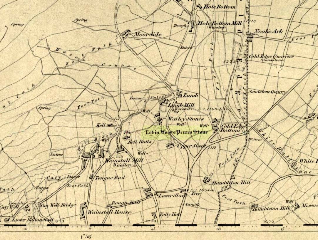
Stone Circle (destroyed): OS Grid Reference – SE 046 288
Archaeology & History
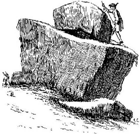
The Pennystone on 1852 map
All remains of this site, first mentioned as a stone circle in 1836, have gone. The place could be found by the appropriately named Stone Farm at the top end of Wainstalls and was first mentioned by John Watson (1775), who strangely said nothing about any circle here. However, this changed when John Crabtree (1836) arrived and described a ring of stones surrounding a large boulder in the centre (illustrated here). The boulder itself was actually called the Robin Hood Penny Stone.
Folklore
Watson’s 1775 drawing
This was one of the many legendary sites from where our legendary outlaw practiced shooting his arrows. He was also said to have picked up and thrown a large standing stone from this spot, until it landed three-and-a-half miles away on the hillside on the other side of the Calder Valley. (this was known as the Field House, or Sowerby Lad Standing Stone)
Crabtree, John, Concise History of the Parish and Vicarage of Halifax, Hartley & Walker: Halifax 1836.
Dobson, R.B. & Taylor, J., Rymes of Robyn Hood, Alan Sutton: Gloucester 1989.
Faull, M.L. & Moorhouse, S.A., West Yorkshire: An Archaeological Guide (4 volumes), WYMCC: Wakefield 1981.
Varley, Raymond, “A Stone-Axe Hammer, Robin Hood’s Penny Stone and Stone Circle at Wainstalls, Warley, near Halifax,” in Yorks. Arch. Journal 69, 1997.
Watson, John, The History and Antiquities of the Parish of Halifax, T. Lowndes: London 1775.
The reverend John Watson (1775) first wrote about this place, describing it as, “a group of stones, laid, seemingly, one above another, to the height of several yards, and called the Rocking stone.” Very little archaeological remains have been described hereabouts, save the odd flint scatters here and there. Anything which might have been here in the past was likely destroyed when the M62 was built right next to the site.
Folklore
The rocking stone was long ascribed in local tradition to be a site used by the druids. It was said that in bygone days the great boulder would rock, but this must have been a long time ago as even when Mr Watson described it, he told how “that quality is lost.”
Close by is the sometimes dried-up spring known as the Booth Dean Spa, which Watson thought might have been related to whatever ancient rituals occurred here.
References:
Watson, John, The History and Antiquities of the Parish of Halifax, T.Lowndes: London 1775.


")