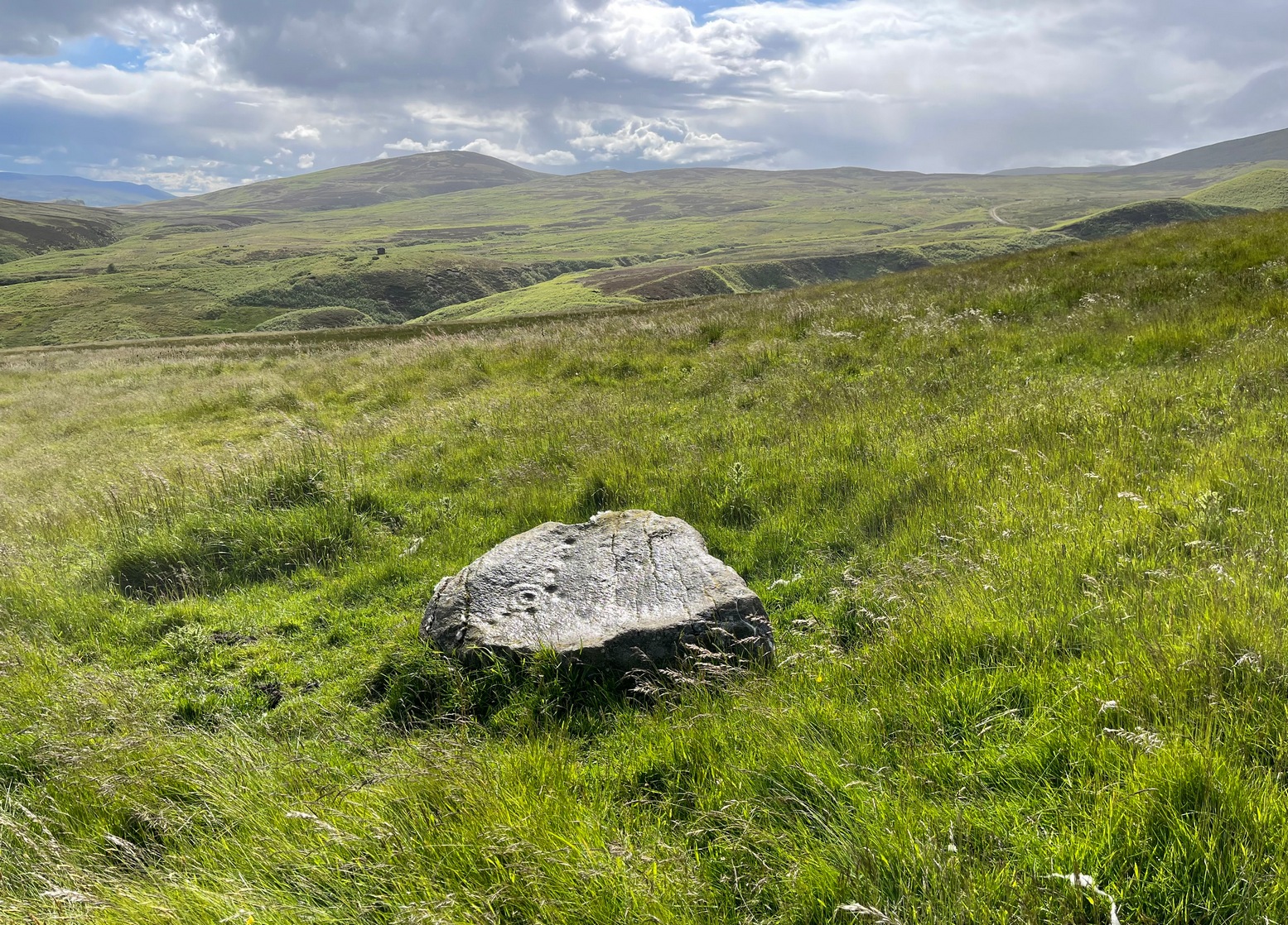
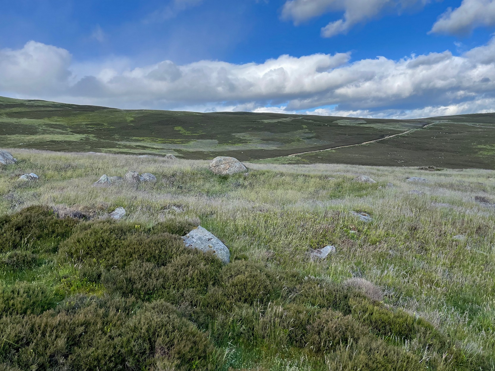
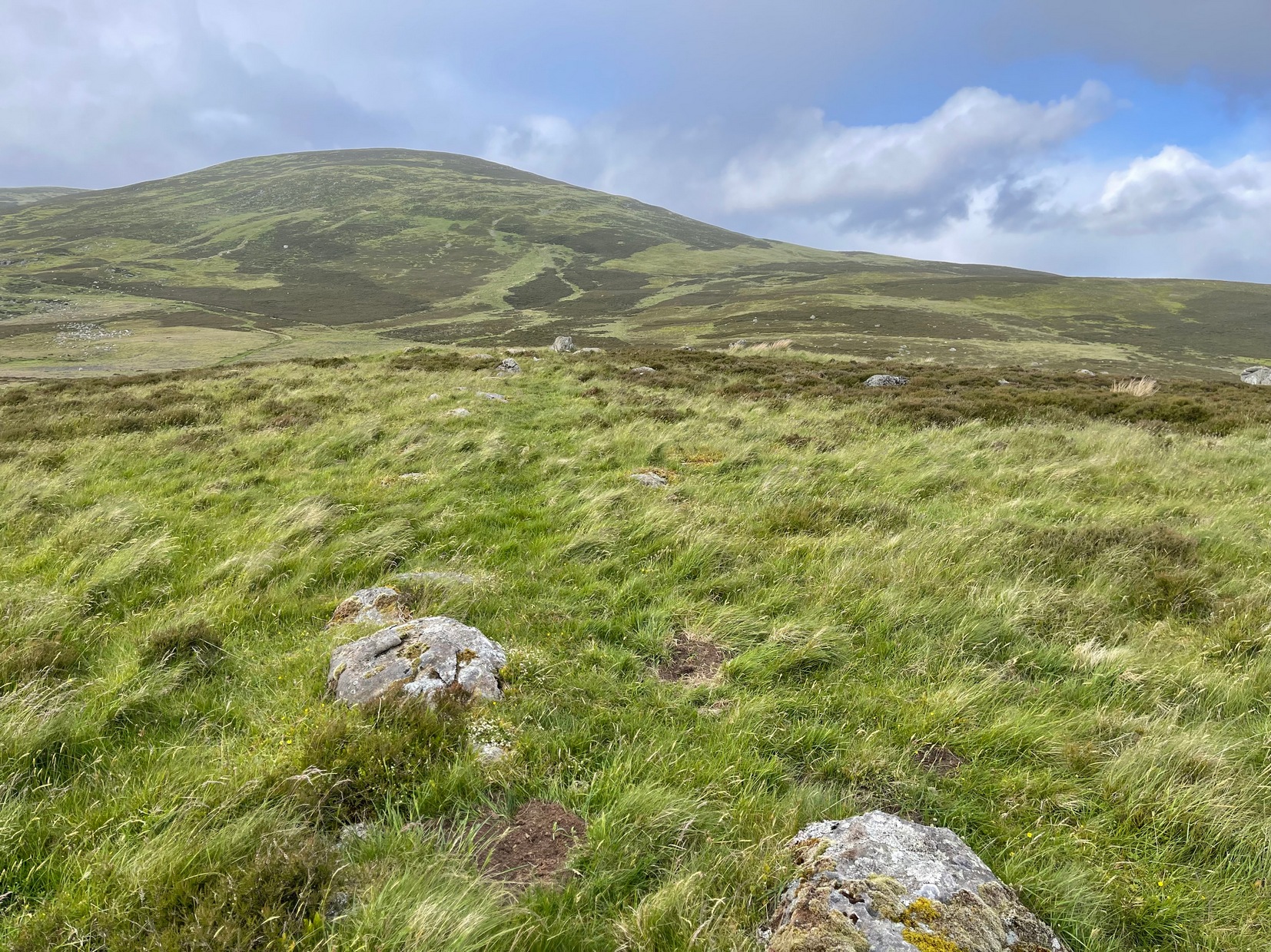
A couple of miles east of Crieff, take the A822 road from the Gilmerton junction and head up towards the Sma’ Glen. After literally 1¾ miles (2.8km), on the right-side of the road, you can park-up right opposite the dirt-track that leads up to Connachan Farm a half-mile away. Keep walking up past the farm to the Connachan (2) petroglyph, and keep to the track uphill for another 600 yards keeping your eyes peeled for a notable singular rock on your left, about 10 yards into the heather. It’s pretty easy to see. If the track’s levelled out, you’ve gone too far!
Archaeology & History
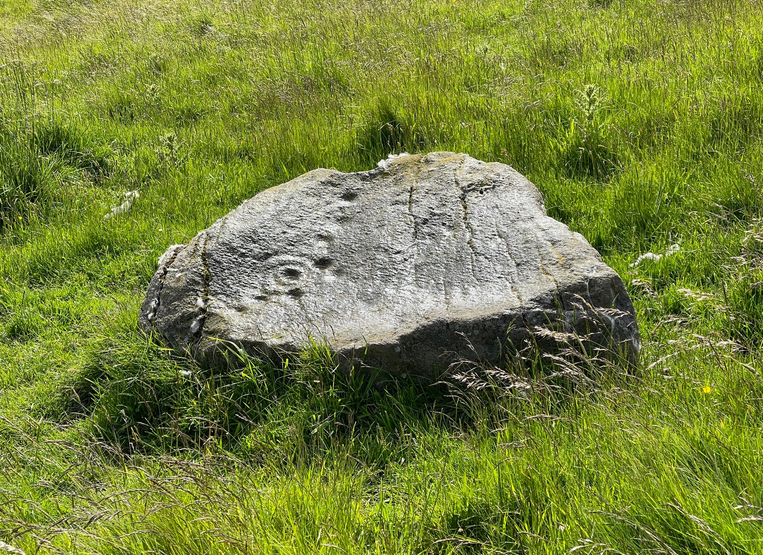
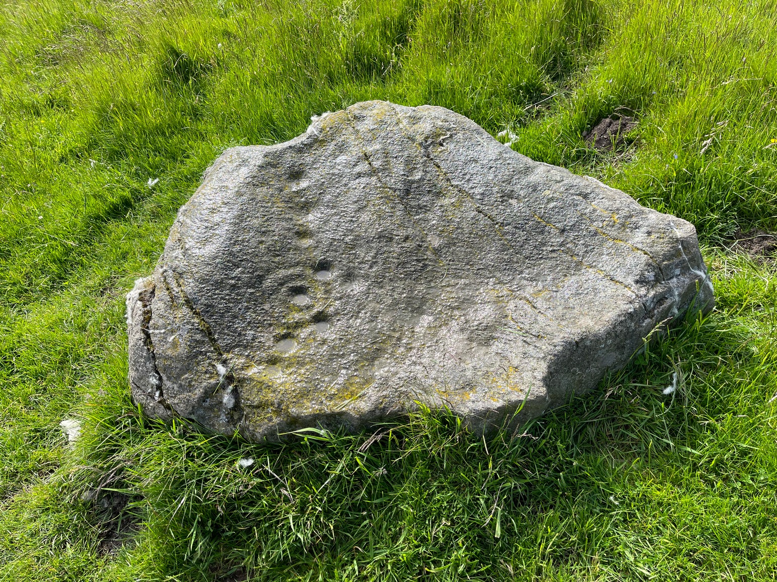
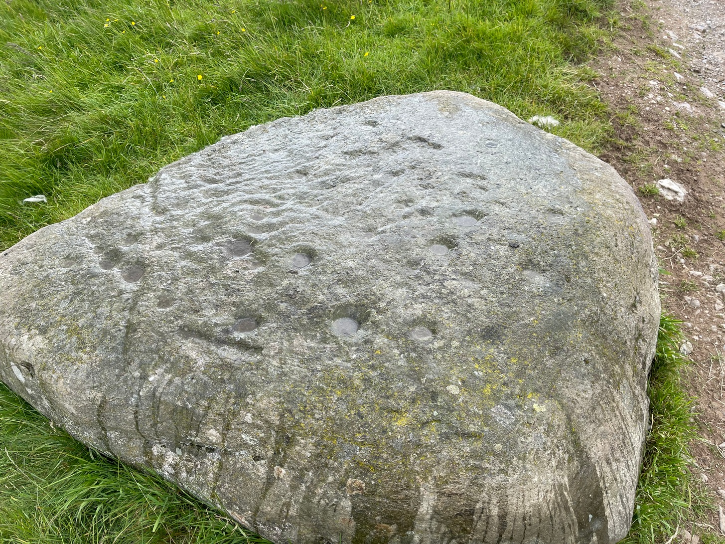
Perhaps the most attractive of the Connachan petroglyphs is this curvaceous stone with its archetypal double-ringed motif. It seems to have been described firstly by Margaret Stewart (1967), whose description (to me at least) doesn’t quite do it justice; but then, they are somewhat troublesome abstract creations most of the time. She told it to it be,
“a boulder 4’10” x 3’10 x 2′ in height with 6 cups and a grooved circle, which incorporates two more cup marks on its outline. The grooved circle encloses a gapped circle with another cup mark at its centre.”
Connachan (4), looking NMain face of the carving
So, nine cups in all: one with the double-ring around it, and two of the cups touching the outer ring. The cup-marks are ostensibly as Stewart described them, but there are another two or three which I was unable to capture in the photos, as the daylight wasn’t good when we came here. They’re shallow but very distinct when you see and feel them in the flesh, so to speak, and are closer to the top- and bottom-centre of the stone in the photos here. Well worth checking out if you’re in the area!
References:
Stewart, Margaret E.C., “Connachan, Crieff – Cup Marks and Hut Circle,” in Discovery & Excavation, Scotland, 1967.
Acknowledgements:Huge thanks for use of the Ordnance Survey map in this site profile, reproduced with the kind permission of the National Library of Scotland.
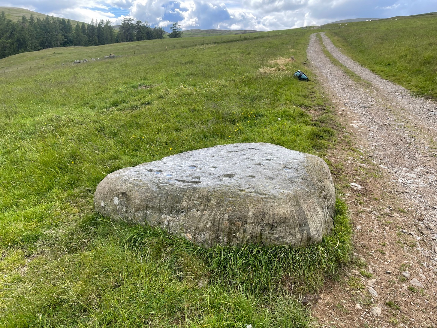
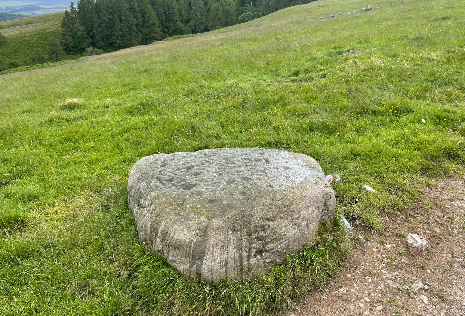
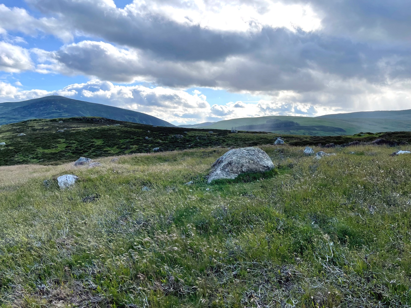
A couple of miles east of Crieff, take the A822 road from the Gilmerton junction and head up towards the Sma’ Glen. After literally 1¾ miles (2.8km), on the right-side of the road, you can park-up right opposite the dirt-track that leads up to Connachan Farm a half-mile away. Keep walking up the track, past the farm and the cottages, and about 300 yards further along, right by the track-side, you’ll see a large stone. Y’ can’t really miss it!
Archaeology & History
This carving was seemingly rediscovered by J.H. Maxwell of Crieff in the 1960s, but not in the position it presently occupies by the trackside. A large body of field clearance rocks lies scattered 60 yards to the west, which is where it was reportedly first seen; which means that, even then, it wasn’t in its original spot. But at least we can be assured that it came from somewhere very close to its present location, by the trackside.
Close-up of cups & linesThe carving, looking SW
It’s not overly impressive in terms of its design, comprising almost entirely of cup-markings: at least thirty, perhaps as many as thirty-four. When we visited here recently, Nature wasn’t overly concerned about giving us decent daylight, so we couldn’t see the carving clearly, but it did seem that a carved broken “ring” swerves around at least one of the cups near the middle of the stone. You can make it out in the photos here (centre-left). There are what seems to be several other carved lines on different parts of the stone but, again, without decent daylight, we could neither get decent photos, nor do a decent sketch of them. The Scottish Rock Art Project, who got themselves nigh on a million quid to survey all our carvings up here, neither sketched, photographed or visited this or the others in this Connachan petroglyph cluster, so we’re none the wiser as to its original form. If you happen to visit this carving when the daylight is being nice, see if you can catch us a good photo or two and stick ’em on our Facebook group.
References:
Stewart, Margaret E.C., “Connachan, Crieff – Cup Marks and Hut Circle,” in Discovery & Excavation, Scotland, 1967.
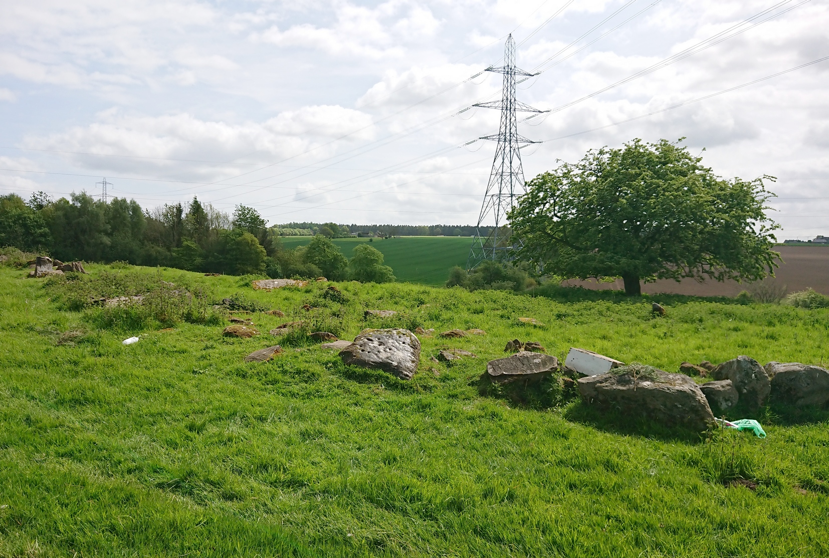
Go west out of Perth city centre, along Longcauseway which runs straight into Jeanfield Road, then (keep your eyes peeled) turn left and go along Burghmuir Road to the end where, at the roundabout, go straight across. 100 yards along, a dead straight path starts on the left-side of the road. Walk 400 yards along here, cross the road, keep straight on the path (called Old Gallows Road) into the trees and a half-mile on you reach a large pylon on your right; but walk to your immediate left here and after 25 yards go through the gate on your left. In this field, 100 yards to the south you’ll see a tree inside a large low stone enclosure. You need to find the stone that’s the most northerly one in this enclosure walling.
Archaeology & History
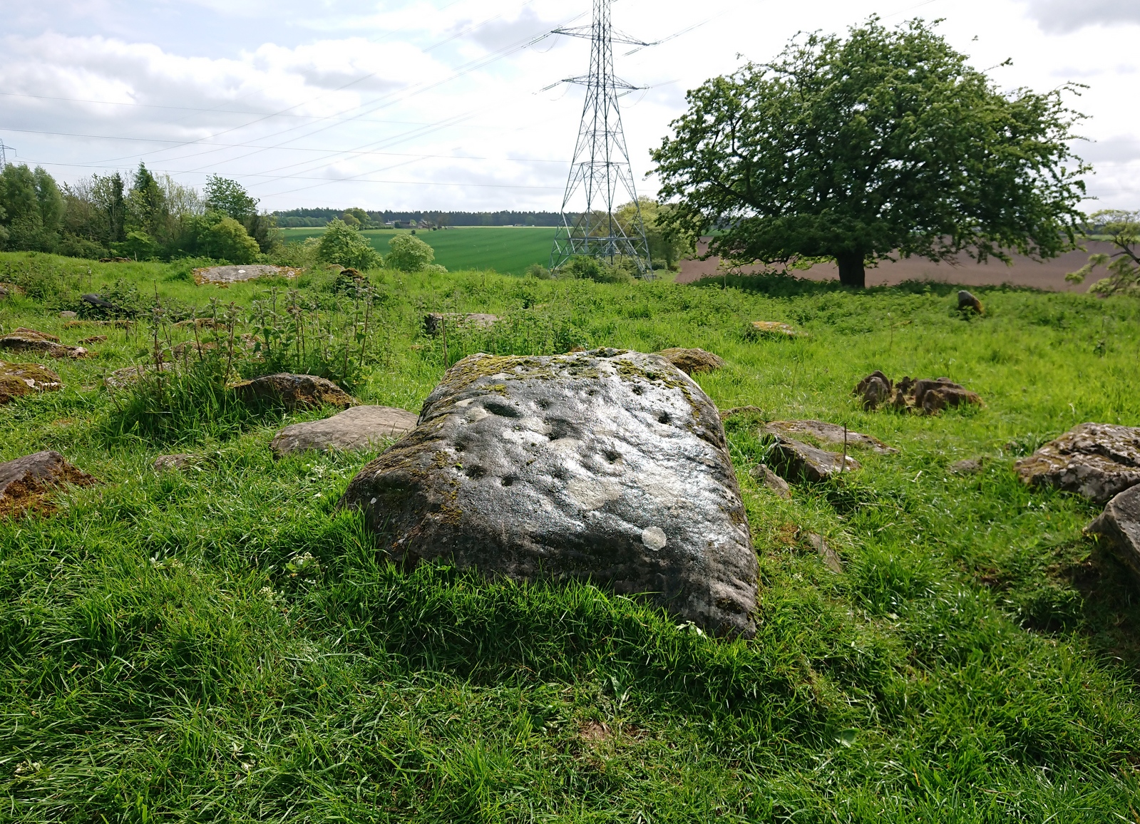
It’s debatable as to whether or not this carving is in its original position as it’s located within the outer walling of an enclosure, deemed by Fred Coles (1903) to have been a large garden, yet which has all the hallmarks of being much earlier structure, possibly even Iron Age. Either way, the cup-and-ring that we see today on the northernmost edge of this old walling, would seem to have been moved into the position it presently occupies.
Close-up of the carvingPosition in line of walling
There’s another oddity about it too, as one (or more) of the cup-markings have been incised and worked upon in much more recent centuries, as evidenced by a small thin almost pencil-like cut into the centre of one of them, perhaps with the intention of smashing the stone to pieces. A geologist or stonemason could perhaps look at this and let us know what they think. Thankfully the stone and the carved design remains intact!
It was described by the great Fred Coles (1903) in a summary essay of numerous antiquities both here and further afield. He told us:
Coles (1903) sketchClose-up of the design
“The cup-and ring-marked stone here was first brought to my notice by Mr David Smith in the summer of 1900. He then reported that the stone appeared to be one of a large number forming a rough circle in a plantation on the west of this farm. On reaching the house, I was fortunate in meeting Mr Douglas the tenant, who at once conducted me to the westmost field and showed me the stone. It is a squarish and not very thick block of ‘bastard whinstone,’ uneven, weathered, and moss-grown. It measures 2 feet 10 inches by 2 feet 8 inches. As far as examination in the gloom of the clump of trees allowed, I believe I am correct in recording…the seven single cups and the two surrounded by rings as all the definitely artificial marks now visible on this stone. The stone at present lies prone upon the curved alignment of many stones which have been set on edge, enclosing an area roughly oval, and measuring in round numbers about 210 feet nearly east and west by 90 or 100 feet north and south.”
There are in fact a few more cups with rings than what Coles described, but they’re difficult to make out. At least five have rings, possibly six of them. If you happen to visit this carving when the daylight is being nice, see if you can catch us a good photo or two and stick ’em on our Facebook group.
References:
Coles, Fred, “Notices of…some Hitherto Undescribed Cup-and-ring-marked Stones,” in Proceedings Society Antiquaries Scotland, volume 37, 1903.
Acknowledgements:Many thanks for use of the Ordnance Survey map in this site profile, reproduced with the kind permission of the National Library of Scotland.
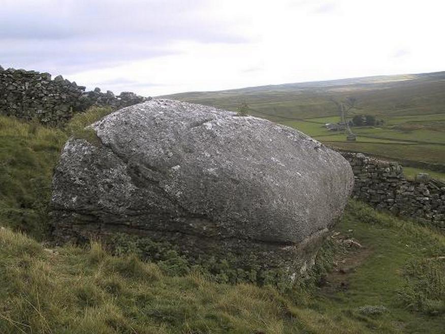
From the small town of Bainbridge, head south down the Carpley Green Road. Less than a mile before the end, look to the west-facing slope of Addlebrough Hill and this huge Devil’s Stone can be seen resting halfway up the slope, just by the wall. Y’ can’t miss it!
Archaeology & History
The Devil’s Stone
Highlighted on the 1856 Ordnance Survey map, one of the legends of this place suggested there might be cup-and-ring markings on the stone, but the curious markings on top of the rock seem to be natural. It’s a superb stone though, dropped here no doubt by some great glacier as it retreated north, in ages truly olde…
There’s a lot of archaeology around here that’s yet to receive the attention of the archaeology textbooks. But if you’ve ventured to see this, have a gander across to the massive prehistoric tomb known as Stony Raise, less than a mile southeast of here.
Folklore
One legend tells that long ago Addlebrough was the home of a great unnamed giant — but a friendly giant by all acounts. However, one day the devil turned up and wanted possession of the giant’s hill and so a fierce row broke out between them. Perched on the top of the crag — which is the rough ridge to the west of here — the giant who lived there hurled huge boulders down at the devil, but they fell short and landed at the side of Lake Semerwater (itself an important spot in local prehistory). In return, Old Nick himself began throwing boulders back — and one of those which the devil threw landed here, halfway up the western flank of Addlebrough Hill (a couple of the large boulders which the giant threw can be seen on the edge of Semerwater and are known as the Carlow and Mermaid stones). Hence it’s name of the Devil’s Stone!
In Edmund Bogg’s Richmondshire (1908), he told how, “the curious markings on (the Devil’s Stone) are accounted due to the pressure of the devil’s fingers” which were caused when he threw this giant stone from somewhere to here.
Site shown on 1856 map
This is a theme we find at countless other stone sites, i.e. the Devil burning holes into rock — and in some cases these devil’s “fingerprints” have turned out to be prehistoric cup-markings. Such tales relate to the pre-christian Creation Myth of a place and would, before the “devil” was supplanted onto a site, have had wider significance in the landscape as a whole, in a manner known only to local people. Devils usually replaced legendary giants, or the hero-figures who created the land in primordial times in the myths of our ancestors. A greater examination of the nearby sites in association with the folklore of the region would no doubt be quite profitable…
References:
Bogg, Edmund, Richmondshire, James Miles: Leeds 1908.
Romney, Paul (ed.), The Diary of Charles Fothergill, 1805, Yorkshire Archaeological Society: Leeds 1984.
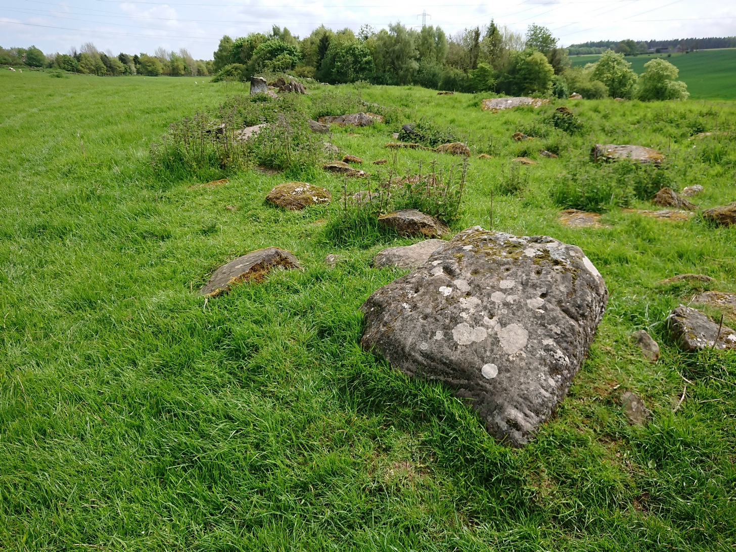
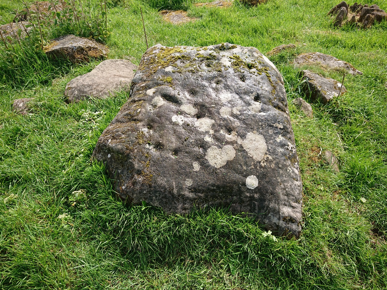
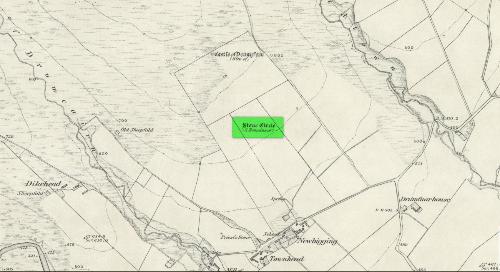
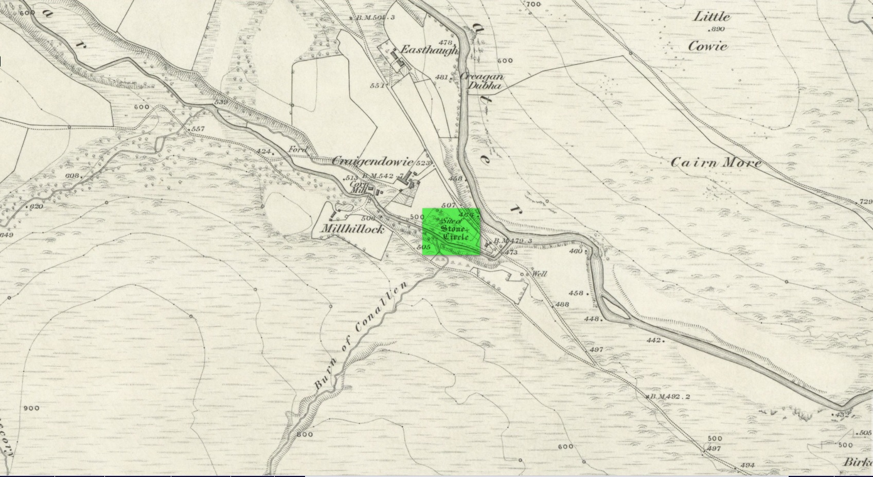
Stone Circle (destroyed): OS Grid Reference – NO 5414 6935
Archaeology & History
Site location in 1863
Entered in Aubrey Burl’s (2000) magnum opus as a stone circle, the site has also been reclassified as a ring cairn or cairn circle, for obvious reasons. We can haggle about definitions if we wanna get a bit anal about it, but even from what little we know, this was an impressive looking site to say the least! Burl (1976) originally suggested that it may have been a recumbent stone circle: an Aberdeenshire outlier, so to speak—and he may have been right. Sadly the place has been destroyed, like so many megalithic rings in this neck o’ the woods.
It was first mentioned, albeit briefly, by Alexander Gardner in his 1843 summary of the parish in the New Statistical Account where he told that, “there are the remains of a Druidical Temple at Newbigging near the remains of an ancient Castle or Tower called Dennyfern.” Our main source of information comes via the early Ordnance Survey lads after they’d visited the place in 1861. They wrote:
“Though nothing now remains of this Circle but one very large upright stone, measuring 5 feet 4 inches high, 9 feet in circumference at the base, and 6 feet 3 inches at the top, yet its site is plainly traceable, and is slightly raised from the ground around it. It was an immense Cairn, 40 feet in diameter according to the farmer of Newbigging, containing 400 cartloads of stones which he removed …The one Stone standing is so large that this may be considered to be the remains of a “Stone Circle” of which the large quantity of small stones formed the raised plateau, the ring of which is still visible.”
The great regional historian Andrew Jervise (1853) culled a few extra snippets of information about the place, telling us:
“Some fifty years ago, a good specimen of concentric circles stood on the farm of Newbigging, about half-a-mile north of the house, on an elevated part of the mountain; but, of the twenty or thirty large stones that enclosed an area of from fifty to sixty feet in diameter, only one remains, the rest having been carried away for various utilitarian purposes. This boulder, which is about eight feet high, is sometimes called the Druidical, but more commonly the “Stannin’ Stane of Newbiggin’,” and many flint arrow-heads have been found in its vicinity. When demolished, the middle of the area of the inner circle was found to be filled with small stones to the depth of about three feet, under which lay a quantity of black clammy earth, mixed with pieces of charcoal, while a track about two feet broad, composed of loose red sandstone, laid to the depth of a few inches, ran directly through the clammy earth and pebbles, from side to side of the outer circle.”
Alex Warden (1884) mentioned the remaining Stannin’ Stane of Newbiggin’ in his survey of the area, and the monolith was still in place when Cruikshank (1899), the local minister, wrote his detailed history book, but he added little more by way of Jervise’s description, merely telling that the stone circle
“on Newbigging must have been in its original state interesting and remarkable. It was composed of upright stones of great size, as we can see by the only one now remaining, which is known as “the Stannin’ Stane of Newbiggin’.” The blasted massive remains of the other stones form the foundation of the field dyke close by.”
It’s obvious that Burl’s idea that this circle was a recumbent one is based on Jervise’s description of it being “a good specimen of concentric circles” with the internal cairn structure giving it additional archaeomythic clout. Its complete destruction prevents us knowing anything more.
References:
Barnatt, John, Stone Circles of Britain– volume 2, BAR: Oxford 1989.
Burl, Aubrey, The Stone Circles of the Britain Isles, Yale University Press 1976.
Burl, Aubrey, The Stone Circles of Britain, Ireland and Brittany, Yale University Press 2000.
Cruikshank, F., Navar and Lethnot: The History of a Glen Parish in the North-east of Forfarshire, Black & Johnston: Brechin 1899.
Jervise, Andrew, The History and Traditions of the Land of the Lindsays in Angus and Mearns, Sutherland and Knox: Edinburgh 1853.
Royal Commission on the Ancient and Historical Monuments of Scotland, The Archaeological Sites & Monuments of Central Angus, Angus District, Tayside Region, HMSO: Edinburgh 1983.
Warden, Alex J., Angus or Forfarshire: The Land and People – Descriptive and Historical – volume 4, Charles Alexander: Dundee 1884.
Acknowledgements:Huge thanks for use of the Ordnance Survey map in this site profile, reproduced with the kind permission of the National Library of Scotland.
Stone Circle (destroyed): OS Grid Reference – NO 5225 6924
Archaeology & History
Site shown on 1865 map
All remains of this stone circle have long since bitten the dust. It was already described in the past tense when Alexander Gardner wrote his summary of the parish in the New Statistical Account in 1843 where he told that, “there are the remains of two or three small Druidical temples, one at Newbigging, one at Blairno, and one said to have been at Craigendowie, but now demolished.”
A few years later Andrew Jervise (1853), in his classic tome on the Mearns, gave us the best description of the place, based either on his own personal visit here, or one given to him by a local when he was surveying the history of the area. He wrote:
“In the vicinity of Craigendowie … among the mass of artificial-looking cairns (which are said to be the graves of warriors), there was a small circle, composed of a quantity of stones about the same size, and ranged in the same manner, as those at Fernybank…. Unlike the latter, this circle was never thoroughly explored, even at the time of its removal more than forty years ago, and if as old as prehistoric times, it cannot now be said in how far it may have been a place of sepulture. Craigendowie has, perhaps, its true etymon in the Gaelic Craigandubh, or “the black rock,” for the craig is an immense black rock close by the river-side; but, according to a truer etymology, as well as popular story, it implies the “rock of the funeral cairn,” or perhaps the “craig of battle or mischief;” and, if any reliance can be placed on the tales regarding the malicious actions of the kelpie in the dark pool beside it, or in the story of warriors having fallen in the neighbourhood, the latter rendering may not be altogether inept!”
When the Ordnance Survey lads wrote about it their Name Book (1861) they told simply of its memory, saying,
“There is now nothing remaining to mark the site except a portion of the ground being still uncultivated, nor is there any person who recollects seeing any remains. It is supposed to have been demolished in making an old road through it, the track of which is still plain.”
And, later still in Cruikshank’s (1899) major work on Lethnot township he added little extra information other than saying that “it was situated in the field in front of the farmhouse (but) is entirely destroyed.”
References:
Cruikshank, F., Navar and Lethnot: The History of a Glen Parish in the North-east of Forfarshire, Black & Johnston: Brechin 1899.
Jervise, Andrew, The History and Traditions of the Land of the Lindsays in Angus and Mearns, Sutherland and Knox: Edinburgh 1853.
Royal Commission on the Ancient and Historical Monuments of Scotland, The Archaeological Sites & Monuments of Central Angus, Angus District, Tayside Region, HMSO: Edinburgh 1983.
Warden, Alex J., Angus or Forfarshire: The Land and People – Descriptive and Historical – volume 4, Charles Alexander: Dundee 1884.
Acknowledgements: Huge thanks for use of the Ordnance Survey map in this site profile, reproduced with the kind permission of the National Library of Scotland.
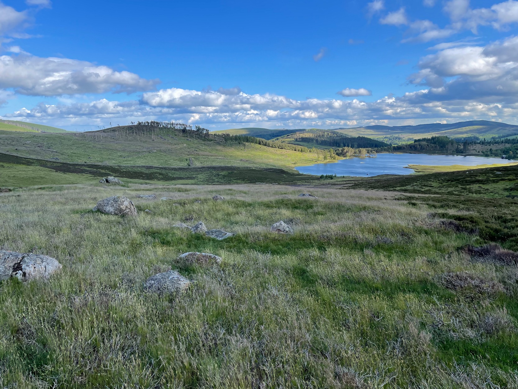
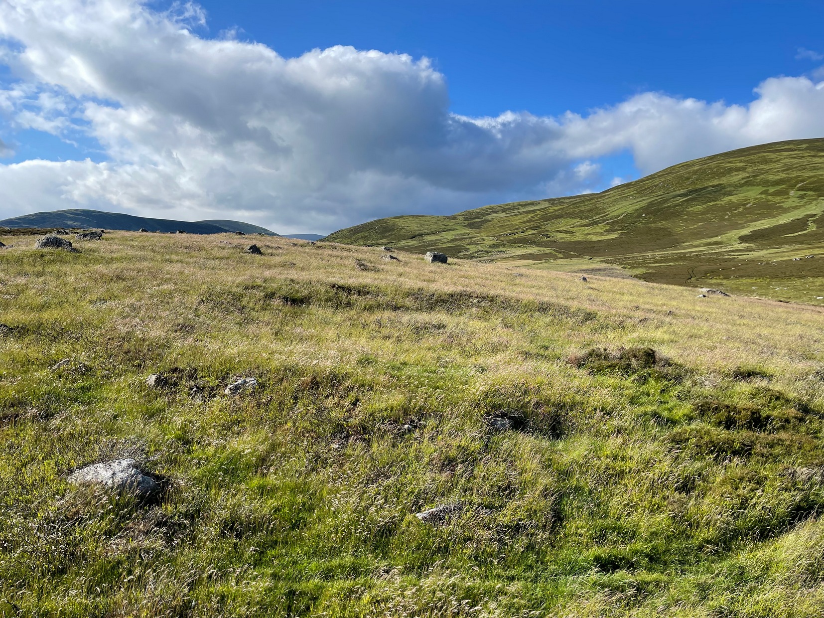
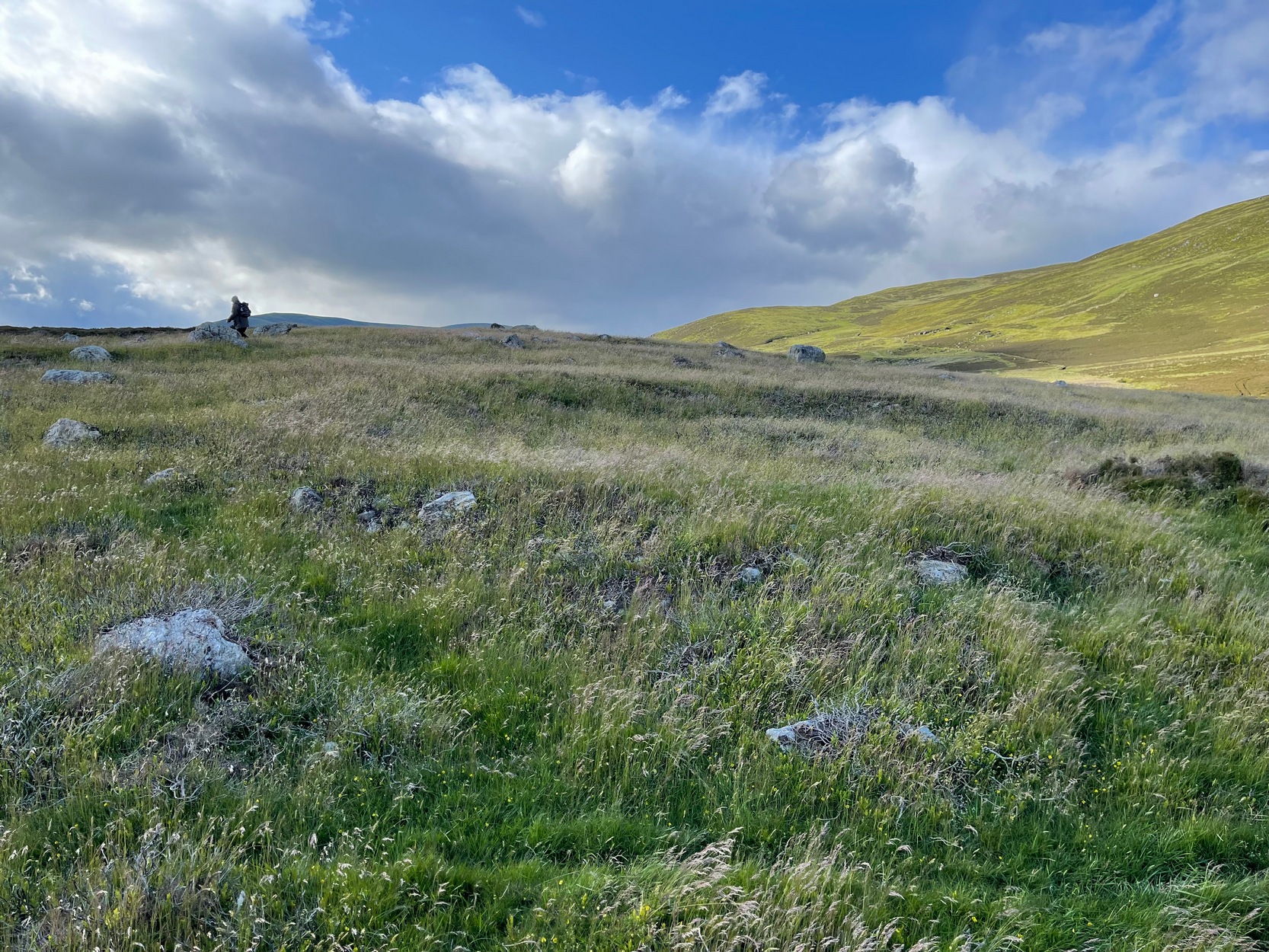
From Alyth, take the B954 road north to Glen Isla, or from Kirriemiur northwest up the B951. Whichever your route, once you pass the Kirkton of Glenisla about 10 miles up, make sure you DON’T cross the river bridge a mile past here—instead take the tiny right-turn just before the bridge and go up here (past Folda) for just over 2 miles and then park up where the signpost tells Cateran Trail (if you’ve crossed the next river bridge, you’ve gone 150 yards too far). Walk up the track and, after a mile, it levels-out just where it swerves to go back downhill. Once here, walk off the track and up onto the moorland on your right (south) and where the land levels out, zigzag around, keeping your eyes peeled for the circular stone enclosures. There are several of them.
Archaeology & History
On the way back from seeking out a forgotten holy well at Auchenchapel in the hills above Glen Isla last week, I stumbled across a small group of hut circles which, it turns out, weren’t in the record books. Unfortunately I found them near the end of the day, so it was a bit of a rush-job zooming back and forth taking quick photos of what was there, i.e., at least three hut circles, probably Iron Age in origin (although I’ve seen Bronze Age circles just like these) constructed very close to each other, with a possible fourth one buried in deeper heather nearby. The circles have been built on a high exposed ridge linking Glen Isla to Glen Clova a few miles to the east, but when these were built this area would obviously have possessed a good cover of birch, hazel and other trees, protecting the structures from the elements.
Hut circle (1) looking NWGolan Well hut circle (1)
The first one—hut circle (1) (at NO 19765 65581)—has been built and cut into a slight slope in the hillside, with the floor inside obviously leveled out. Measuring roughly 16 yards across from outer wall to outer wall, the entrance to the building seems to be on the eastern side and the average height of the walling all round is roughly 2 feet. On the whole the structure is in very good condition, with hardly any damage done despite its great age. It was obviously built for a single family, but was no doubt used over and over for many centuries.
Hut circle (2) looking NEHut circle (2) looking SW
The second of the circles (at NO 19741 65590) is just 15-20 yards away to the northwest. Slightly smaller than hut circle (1) and also built into slightly sloping ground, its walls are a little more sturdy and slightly wider than its compatriot and were built around at least two earthfast boulders making it structurally much stronger. Measuring roughly 15 yards across from outer wall to outer wall, the entrance to this circle is at the southeast. Once again, this would have been perfect for a single family to live in.
Hut circle (3) looking NWThe small hut circle (3)
The third of the hut circles found this day was the smallest of the group and suggests that it would have housed only one person. The stones making up this small circle are unusually large for such a small structure, which made me think at first that it may have been a cairn—but the more I looked, the more I realized that this wasn’t the case. Somewhat more oval in shape than the other two, unlike its compatriots some parts of the walls seem to have been disturbed and knocked down to the side. The poor little fella measures only 8 yards across, but its walls were still nice and sturdy being roughly a yard wide all round.
Line of ancient walling
What seemed to be a fourth hut circle was covered in deep heather close to the cluster of three, but we need another visit here to work out whether this suspicion is correct or not. Much more certain is the existence, less then a hundred yards northwest of here, of a very distinct line of ancient walling, about a yard wide, suggesting that the hut circles were encircled by a much larger enclosed structure. I paced along this walling for 60 yards, whereafter it disappeared into the heather.
It’s extremely likely that other unrecorded prehistoric remains are still to be found in this area. So get y’ walking boots on and get that nose of yours a-twitching across these ‘ere ancient hills!
Acknowledgements:Huge thanks for Prof. Paul Hornby, for getting us up here and having another fine day on the hills…
From Alyth, take the B954 road north to Glen Isla, or from Kirriemiur northwest up the B951. Whichever route you take, goes for miles, then past the Kirkton of Glenisla for another mile make sure you DON’T cross the river bridge—instead take the tiny right-turn just before the bridge and go up here (past Folda) for just over 2 miles and park up where the signpost tells Cateran Trail (if you’ve crossed the next river bridge, you’ve gone 150 yards too far). Walk up the track for a mile where it just about levels-out, before swerving back downhill again and, shortly after crossing a burn, turn right and head downhill into the heathlands. About 350 yards down, right beside the track, this overgrown hut circle lives! Y’ can easily walk straight past it if you’re not careful.
Archaeology & History
The hollowed hut circle
In a beautiful setting, this good-sized Iron Age hut circle (possibly earlier), roughly fourteen yards across, sits within a wider archaeological environment of human settlements all round here from medieval and later periods, most of which has almost entirely disappeared beneath the vegetation on these gorgeous moorlands. It’s one of a number of remaining prehistoric circles that still live amidst the later remains and would have housed a good-sized family or two. The walls alone are roughly six-feet thick all round, making it a very solid building indeed! In all likelihood, other hut circles have been torn down for use in the construction of the later medieval buildings nearby. Thankfully, like the very well-preserved cluster up the slope above Golan Well, this one survived.
Cup-Marked Stone (removed): OS Grid Reference – NT 128 709
Archaeology & History
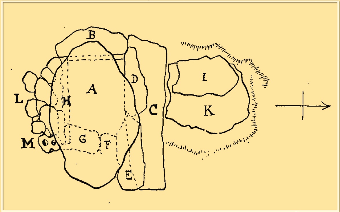
“M” marks the cupmark
A simple cup-marked stone was located inside a prehistoric burial cist that was discovered by quarry workmen in November 1897. The cist was subsequently excavated by Fred Coles (1898) who found therein (amongst other things) a simple cup-marked stone whose present locale is a box somewhere in Edinburgh’s National Museum (could someone send us a photo please?). The carving comprises simply of two complete cups and portion of a third, all close to each other on a small stone that was located on the south-side of the cist (see ‘M’ in the attached diagram). Coles described the carving thus:
“During the removal of (some) small stones, one, when the damp soil was rubbed of, showed two cup-marks, about 1½ inch wide each and ½ inch apart. The stone itself measures 5 inches by 4¾, and appears to be but a fragment of a larger one, one edge showing part of a third cup. The cups all show the tool-marks usually noticed on these mysterious sculpturings.”
Cup-Marked Stone (lost): OS Grid Reference – NN 4808 0140
Archaeology & History
On the south-side of Loch Ard, just a few yards from the entrance to Rob Roy’s Cave (one of several), right by the water’s edge are the natural upstanding pillars known locally as Gog and Magog. In Peter Joynson’s (1996) work on Aberfoyle, this site is listed as one in a number of unrecorded cup-and-ring stones in the area. Discovered by a local lady—”the late Mrs Maitland”—here we have,
“two huge stones about 30ft high known as Gog and Magog situated at the mouth of Blan Ross Bay. They have numerous cup marks, but sadly have disappeared from view as they have been covered by forestry planting.”
This is an increasingly annoying problem that many rock art students are having to contend with! When we visited the site, the tops of these huge stones were, indeed, covered in depths of mosses and pine needles and the carving is hidden from sight. When the trees are felled, let’s hope someone can find it!
Folklore
These natural rocks were said to have been two giants that were turned to stone, the story of which seems to have been forgotten…
References:
Joynson, Peter, Local Past, privately printed: Aberfoyle 1996.