Cup-and-Ring Stone: OS Grid Reference – NC 635 384
Archaeology & History
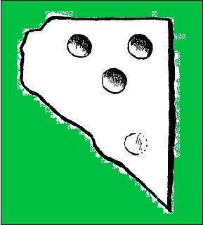
This small cup-marked stone came to light following the work of Mr Angus MacKay of Sutherland, more than 100 years ago. In his essay in the Scottish Antiquaries journal (1905), he wrote the following:
Grumbeg carving
“A cup-marked stone was found by me in the burial place of Grumbeg, Strathnaver, September 1905, standing upright at the head of a grave, and showing about 6 inches above the ground. It is evidently a fragment of a larger slab: its extreme length is 20 inches, and it is about 15 inches at its broadest part. The upper three circles are 2.5 inches in diameter and 1.5 inches deep, very symmetrically hollowed out, but the fourth and lower circle is shallow and indistinct. As the stones covering the other graves are for the most part what is called rough mountain slabs, it seems to me that this cup-marked fragment was found in its present condition elsewhere, and placed here to conveniently show a lair.”
If such was the case, a good contender might be the denuded chambered cairn close by.
Standing Stone (destroyed): OS Grid Reference – SO 117 544
Also Known as:
Hundred House Standing Stone
Archaeology & History
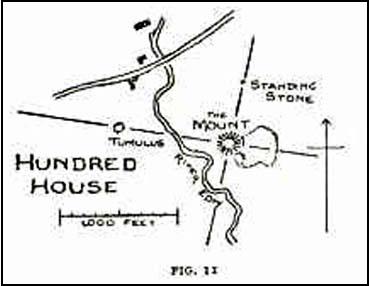
Position of the old stone (on one of Alf’s leys)
In a field less than 200 yards north of an old medieval mound known as The Mount, the great ley-hunter Alfred Watkins (1925) described a standing stone that used to be here along one of his leys, but which, even then, had been “inexplicably blown into several pieces by a quarrymen’s charge.”
The stone was said to have originally come from an adjacent field and then moved next to yet another monolith, which was also broken up. Can any remnants of these poor fellas still to be seen anywhere nearby? Or is it a case of yet another one bites the dust?
References:
Watkins, Alfred, The Old Straight Track: Its Mounds, Beacons, Moats, Sites and Mark Stones, Methuen: London 1925.
From the South Kirkby library, go west along Hague Lane and take the left turn up Homsley Lane on your left after a few hundred yards (keep your eyes peeled!). Go up here, past the housing estate, and where the trees begin on your left at the top of the Hilltop Estate, go thru them and as you emerge out the other side, the earthworks are all around you. In fact you’re just about in the middle of this hillfort-cum-settlement!
Archaeology & History
W.S. Banks (1871) gives an early description of this site, although he thought it to be Saxon in nature. He told that,
“About half-a-mile east of Ringston Hill, in a field between Quarry-road and Hornsley-road, is the site of a supposed Saxon camp, as it is called on the ordnance map — a large enclosure containing above three acres of land. It slopes to the north, and is now rough and uneven, and has been cast into ‘lands.’ The mound on the east, west and south is still very distinct. The northern side is much lower than the other and a ditch is cut across at that part…”
And in Banks’ day, as he told, “the history of it is not known.” But this site was later declared as a hillfort – a Brigantian one at that – for the first time by the director of Wakefield Museum, Mr F. Atkinson, following some excavation work here in 1949. Nothing much was found apart from,
“pieces of decayed and burnt sandstone and medieval pottery sherds,” though he still concluded the site to be Iron Age. Although little of its original form can now be seen due to extensive damage, infra-red aerial photography showed “traces of a five-sided annexe to the northwest, the line of the ploughed-out rampart to the south-southwest, and a possible defended entrance to the south.”
The same aerial survey also found another enclosure to the east of the hillfort.
…to be continued…
References:
Banks, W.S., Walks in Yorkshire: Wakefield and its Neighbourhood, Longmans Green & Co.: London 1871.
Keighley, J.J., ‘The Prehistoric Period,’ in Faull & Moorhouse’s, West Yorkshire: An Archaeological Survey, I, WYMCC: 1981.
Cup-and-Ring Stone: OS Grid Reference – NT 251 696
Archaeology & History
Braid Hills carving
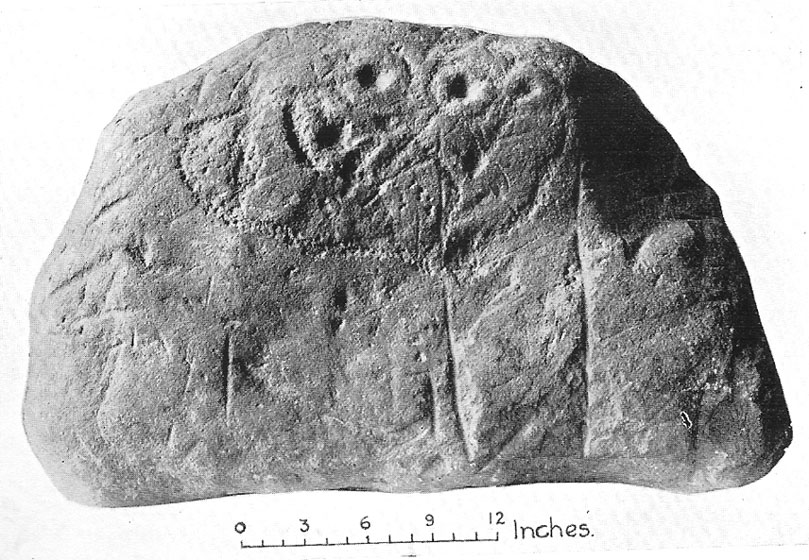
This is a fine-looking old cup-and-ring stone! Although no longer in situ (one of those really important golf courses needed to be built, so it had to go!), the 3 or 4 cup-and-rings seen here, carved at the end of what look like some sort of ‘stalks’, emerging from a distinctive radial under-curve, gave me a somewhat anthropomorphic impression of chaps in a boat — perhaps sailing into the Firth o’ Forth a short distance away! The Scottish Royal Commission (1929) report said the following of the stone:
“In 1897 a boulder of white sandstone with cup-and-ring markings on its surface was discovered on the Braid Hills golf course, and it was later presented to the National Museum of Antiquities. The stone measures almost 3 feet by 1 foot 9 inches, by 1 foot thick and is roughly oblong. The markings comprise seven cups in all, and at least three of these are completely surrounded by a ring and cut by a radial channel.”
Although nothing was said in the RCAHMS account, the stone gives one the impression it was associated with a tomb. And I know it aint the same, but when I first saw this carving, it reminded me of the Ri Cruin carving in Kilmartin, Argyll. It’s the potential “boat” feature that did it for me!
References:
Royal Commission on the Ancient & Historical Monuments of Scotland, Inventory of Monuments and Constructions in the Counties of Midlothianand West Lothian, HMSO: Edinburgh 1929.
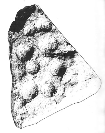
Prehistoric petroglyphs are rare things indeed in Leicestershire! But the example that was found here — at the now destroyed prehistoric tomb which archaeologists catalogued as ‘Lockington Barrow VI’ in this small graveyard — shows that such ritual art spreads further afield than previously reported by archaeologists. Yet as with countless other cup-marked stones, it should come as no surprise to be found associated with a tumulus. Death and petroglyphs are common bedfellows – even in this part of Britain!
Lockington cup-marking (courtesy Gwilym Hughes)Lockington cup-marked stone
Found on the northern edge of a ring ditch surrounding this once-fine tomb, the carving was found on a small, triangular-shaped, broken piece of rock , less than 12 inches across along its longest side. The small stone has what seems to be eight cup-marks (5 seem certain) pecked onto the stone: simple, without additional ingredients, akin to the basic forms found at Baildon and other more northern climes. The stone itself didn’t seem to be local and was thought by Hughes (2000) “to be from one of the outcrops of millstone grit to the north of the site in southern Derbyshire.”
Less than 7 feet from this petroglyph, inside the barrow, was a pit containing a hoard of ancient gold and copper ware — though any likely relationship between the carving and the treasure hoard is doubtful. The carving was probably a “portable” relic, carried some distance and put here for some reason or other: perhaps as an offering; perhaps a magickal artifact — we’ll probably never know…
From Menstrie, walk up the path behind the post office and head up onto the hills, following the track that runs up alongside the Menstrie Burn. After about 500 yards, crossing a stream, the path has a sort of hairpin kink and, shortly past this a smaller path leads off up into the grasslands on your left. The standing stone can be seen up this path about 100 yards up.
Archaeology & History
The Lipney Stone
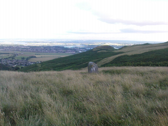
We came across this small standing stone, less than four feet high, after running and jumping down the steep eastern slope of Dumyat at some speed — or rather, Naomi came across the little thing and then told me about it after I’d run round and further down the slope towards the upper stretches of the Menstrie Burn (I was knackered!).
It’s a curious little thing inasmuch as it stands here alone, with no other companions close by; although there were a number of other stones scattering the grasslands hereabouts and other stones may await discovery. Little seems to have been said of the site. The Canmore record tells:
“It measures 1.1m in height, 0.7m in breadth and 0.4m in thickness, and is aligned with its long axis NE-SW. It rises with straight sides and leans to the SE.”
There are extensive remains of earthworks scattering the slopes hereby, though much of this seems medieval in nature. Any further information about this old stone would be much appreciated!
Go west along the A44 from Salford village ’til just before the crossroad with the A436. 100 yards before here there’s a small left turn, downhill, past Hollis Hill Farm and Park Farm. Before reaching Cornwell at the bottom, walk into the fields to your left and find the township boundary (on 1:25,000 OS maps), which is marked with old hedges. It’s in here!
Archaeology & History
Walk along the line of old hedges, checking either side if it’s overgrown, until you find this well-worn three-foot tall standing stone (exact coordinate SP 2770 2785) standing in the hedgerow. It’s a cute little thing which may have marked the old boundary line, but it has a distinctly prehistoric feel and look to it, in a region where many old prehistoric remains still linger…
References:
Bennett, Paul & Wilson, Tom, The Old Stones of Rollright and District, Cockley: London 1999.
If you’re not into the walk, get the bus running NE between Dunblane and Greenloaning — the A9 — getting off at the Little Chef on the dual carriageway and cross the road, walking up the track to Upper Whiteston Farm (the owners here are very helpful). As you walk up the track you’ll notice the large upright in the edge of the field a coupla hundred yards to your right. That’s the one!
Archaeology & History
This is a mightily impressive site if you’re into yer megaliths! When it was visited and measured by Mr Hutchinson (1893) in the 19th century he found it to be 9ft 4 in tall; and although it seems quite isolated at first sight, we find that there is another large stone companion laid down not far to the north of here which may have had some relationship with it . But that aside… There are also as many as eight cup-markings on the stone’s eastern face: one large one and seven smaller ones, in no particular order as usual! It was these cup-marks that gave me the impression there was once a burial associated with the stone, but the archaeology records seem silent on such a matter; though folklore tradition tells another story…
Folklore
Mr Hutchinson (1893) told that the legend attached to this stone appears to be “of quite recent date.” He said how,
“In the district the stone is known as the MacGregor Stone, and the tradition accounting for the name is to the effect that here a countryman was sacrificed by the followers of Rob Roy, when forming for the engagement on Sheriffmuir, in order to satisfy the ancient Highland superstition that first-blood was an infallible omen of success… The tradition is precise enough to state that a man of the name Dawson was seized in the adjoining hamlet of Whiteheadston (for such is the orignal name) as a whig, and therefore a foeman and proper victim. Dawson, however, suspecting the intentions of the captors, vehemently professed himself a supporter of King James and was left off. But another inhabitant of the hamlet not so acute or not so hypocritical, was immolated at the stone.”
Hutchinson however, doubts the accuracy of the tale and suggests that the local name of the MacGregor’s Stone derives from the fact that the monolith stands upon land once owned by the MacGregors of Balhaldies, countenancing that the stone “is of much earlier date than the MacGregors of Balhaldie or any other sept of the Children of the Mist.” I think he’s got a point!
References:
Hutchinson, A.F., “The Standing Stones of Stirling District,” in The Stirling Antiquary, volume 1, 1893.
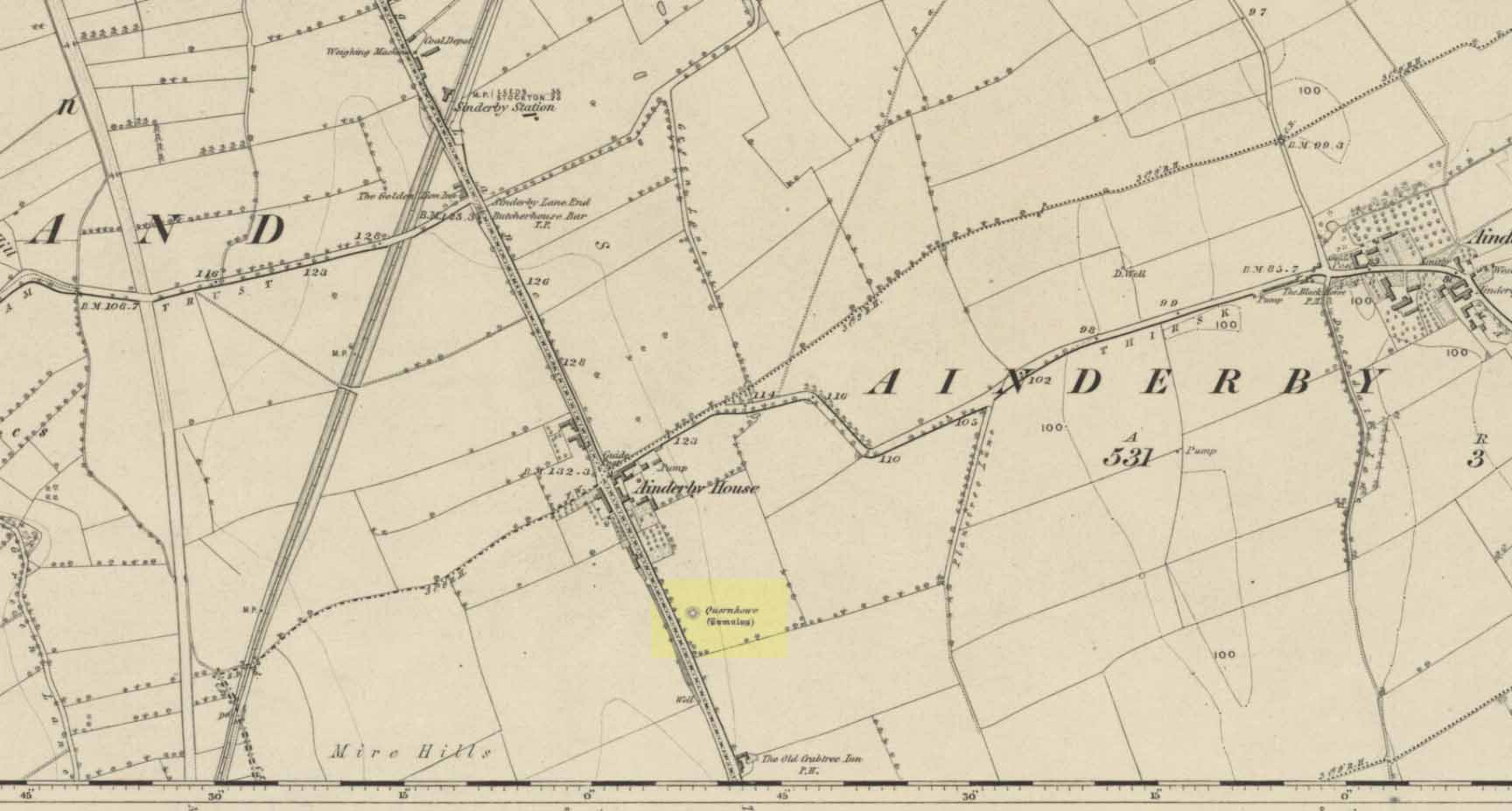
Long since destroyed by the self-righteous advance of the Industrialists, this was a pretty impressive-looking tomb according to the account of D.M. Waterman (1951). Found between the villages of Ainderby Quernhow and Kirklington, right at the side of an important prehistoric trackway—later used by the Romans and known as Leeming Street (on what is now the A1 motorway). Waterman cited it as being “of primary importance in prehistoric times” as it stood on the great plain between the three great henges of Thornborough to the north and those on Hutton Moor to the south, accompanied by a number of other tumuli nearby.
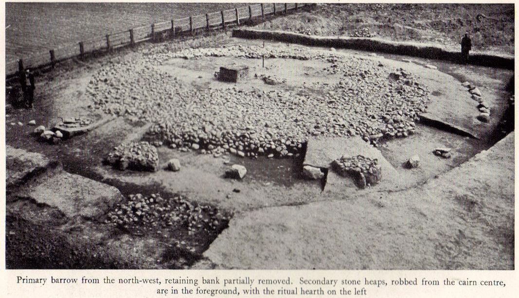
Quernhow tomb on 1856 OS mapThe excavated monument
When Waterman and his team arrived here, the barrow “appeared as a low-spread mound, about 3ft in elevation, the exact limits of which were difficult to define,” due to large parts of it being covered over in mud that’d been dumped there by the local land-owner, aswell as erosion due to other farming or industrial activity. But once the archaeologists had stripped the centuries of soil from the damaged surface of the monument, a most impressive site emerged! At the heart of this great burial mound was found “an imposing stone cairn, more or less flat-topped and with a circular constructed face.” He (1951) continued:
“The material of the cairn was composed of cobbles or boulders, all of local geological origin, ranging in size from a few inches up to a foot in diameter or more. A stone considerably larger in size was occasionally encountered , the largest found measuring 23in by 20in and from 3in to 5in in thickness. The stones were heaped up without any deliberate attempt at producing a stable structure and used indiscriminately, irrespective of size or shape, although there was a tendency for the larger stones to occur towards the perimeter of the cairn. Since the cairn itself was built to a flat surface, and the underlying barrow-mound assumed a saucer-shaped profile, the cobbles perforce increased in depth towards the cairn face; at the very centre they were laid one, occasionally two deep, at the face three or four deep, although irregular size and placing precluded any consistency whatsoever in the work. The standard of the building in fact differed considerably throughout the structure. On the northeast and northwest the facing-stones were quite carefully laid, standing to a height of 22in, the work becoming increasingly shoddy towards the south where the construction had so deteriorated that whole sections of the facing had fallen bodily away from the cairn mass, slipping down the tail of the underlying mound…”
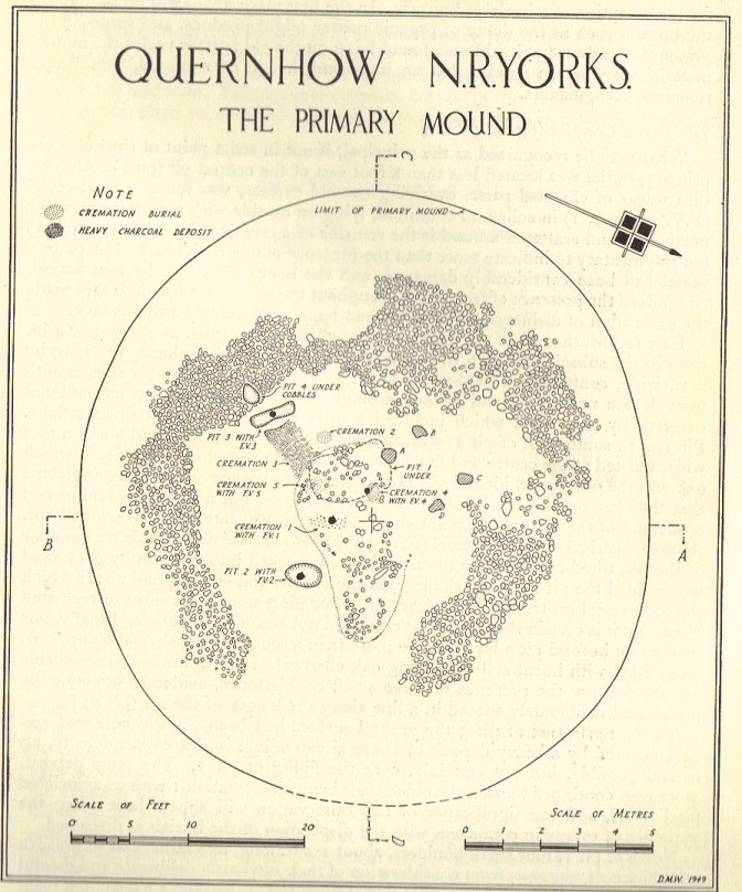
Plan of Quernhow
In the middle of the large cairn were found four small pits and a number of small cremations in and around them. There were also found the usual broken remains of pottery, human bones, charcoal, foods vessels and burnt pieces of oak and other vegetation. Near the centre of the cairn was a curious “four poster” of upright stones, “about 1.4ft long and rather less in breadth and thickness (which) suggest, from consideration of their obviously deliberate and careful placing, some significant function in burial ritual.” The four corners of these stones were close to the cardinal points: north, south, east and west.
References:
Waterman, D.M., “Quernhow: A Food Vessel Barrow in Yorkshire,” in Antiquaries Journal, volume 31, 1951.
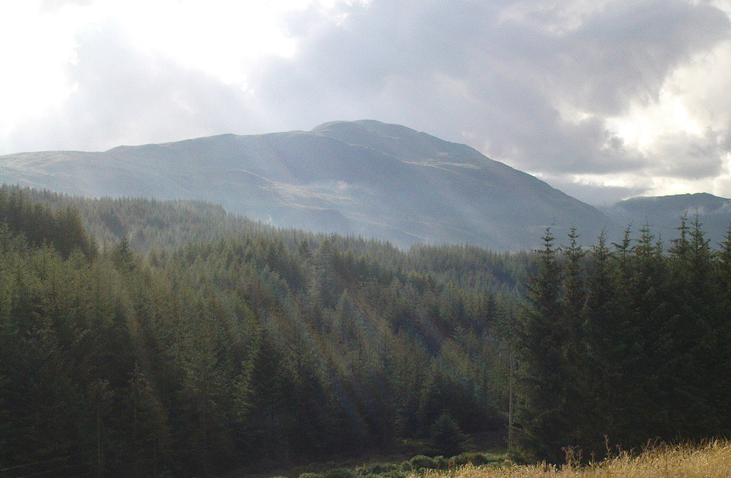
From the tourist-infested (but lovely) town of Callander, look west to the largest of the nearby mountains — that’s where you’re heading! You can keep along the A84 road out of the town for 4-5 miles (past the Falls and Pass of Leny) till you reach the parking spot on your left. Cross the river and go up into the signposted woodland. Keep walking up thru the trees until the rocky mass emerges above you. You can either keep to the path and follow the long walk round the mountain, or go straight up the crags above you. The top’s in sight!
Folklore
Getting up here is no easy task if you’re unfit — but it’s well worth the effort for the journey alone! And in bygone centuries it seems, local people made it a particular pilgrimage at specific times during the year. Even the name of this great hill has some supposed affinity with holy issues; though some modern english etymologists put a dampener on such things. In Charles Rogers’ (1853) excellent Victorian exposition, he told that,
“Benledi is an abbreviation of the Celtic Ben-le-dia, signifying the hill of God.”
But whether the old heathens who named most of these ancient mountains would echo his oft-repeated derivation is another thing altogether! However, there are other decidedly pre-christian events that used to be enacted here, for the summit of Ben Ledi was, tradition tells, where the sun god was worshipped. It would seem, however, that this tradition is a somewhat watered-down version of it as a site of cosmological and social renewal. (see Eliade 1974) For akin to the annual pilgrimage that happens upon Croagh Patrick in County Mayo, Ireland, here upon Ben Ledi,
“For three days and three nights…the inhabitants of the district in those primitive times convened, at the period of summer solstice, on the summit of the mountain, to join in the rites of heathen worship.”
More recent lore tells the date of such sacred gatherings was Beltane. Also a short distance to the north of the summit of Ben Ledi is a small loch known as Lochan-nan-corp. Mr Rogers again tells us that,
“Here two hundred persons, who were accompanying a funeral from Glenfinglas to the churchyard of St. Bride, suddenly perished; the ground had been covered with snow and the company were crossing the lake on the ice, when it at once gave way.”
It seems a most unusual event. But the tale itself implies that a corpse route passed by the way of this high summit, down to the heathen chapel of St. Bride at the bottom of its eastern face: a huge undertaking in itself with probably archaic origins. Does anyone know owt more about this?
References:
Eliade, Mircea, The Myth of the Eternal Return, Princeton University Press 1974.
Eliade, Mircea, Patterns in Comparative Religion, Sheed & Ward: London 1958.
Roger, Charles, A Week at Bridge of Allan, Adam & Charles Black: Edinburgh 1853.