Described by Steve Ford (1987) as “the only known example of a hillfort in East Berkshire,” this much overgrown site encloses an area covering 7.8 hectares. It was first started around 700 BC and thought to be a northern outpost for the Atrebates tribe. However, just over the northern edge of the ramparts, less than half a mile away, a group of seven round barrows were once in evidence, indicating that the the flat plateau on which the hillfort stands would have been of use prior to its construction (Hawkes 1973). The site is described as follows:
“The earthworks consist of a single bank and ditch on the northwest, while elsewhere there is an additional outer bank. At the southern side, the ramparts include a second ditch and a third bank… At present there are four entrances: north, south, east and west, but it would seem that only the eastern and western entrances are contemporary with the construction of the hillfort.”
Archaeologists discovered that the site was made use of by the Romans when their mob arrived, as a coin of Cunobelin as well as Roman pottery was uncovered — although it has to be said that, as a Roman road passes by a short distance to the south, so such finds would be expected.
References:
Ford, Steve, East Berkshire Archaeological Survey, Berkshire County Council 1987.
Hawkes, Jacquetta, Prehistoric and Roman Monuments in England and Wales, BCA: London 1973.
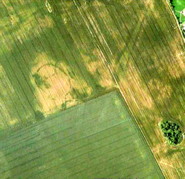
Aerial view of Hasting Hill cursus & enclosure remains
This site was discovered in the 1980s, following aerial surveying of the region. The survey uncovered a number of previously unknown archaeological monuments in relative proximity to each other; the Hastings Hill cursus being just one. There was also a causewayed enclosure and some round barrows some 700 yards south of Hastings Hill Farm. Although no distinctive remains of the earthworks can still be seen on the surface, limited excavation confirmed that significant remains survive beneath the ground. (in the aerial image here, note that the cursus in question aint the long thin crop-mark running to the top-left, but is the small, slightly rounded-end linear feature nearly touching the bottom-right of the oval enclosure)
“Sections of the ditches of both the cursus and causewayed enclosure were excavated by the Department of Archaeology, University of Durham in 1980. The cursus is orientated north-south. At its northern terminus the cursus is 47m wide and is defined by a 1m wide, asymmetrical ‘V’ shaped ditch, which was 0.4m deep. The southern terminus has not been identified, but the cursus is at least 400m long. The causewayed enclosure lies 10m north west of the northern terminus of the cursus. It is an irregular oval, 92m by 65m, with its long axis orientated north-west, south-east defined by a 1m-2.2m wide ditch, which is 0.2m-0.3m deep. It has entrances in the north west and south east perimeter of the enclosure. One of the round barrows, which is 9m in diameter, is on the eastern perimeter of the enclosure. The other round barrow ditches are located just east of the cursus, 400m south of the causewayed enclosure. One of these has been measured at 20m-22m diameter. The cursus, causewayed enclosure and round barrows are interpreted as being of Neolithic date.”
References:
Horne, P.D., MacLeod, P. & Oswald, A., ‘A Probable Neolithic Causewayed Enclosure in the North of England,’ in Antiquity Journal, March 2001.
Get to the Twelve Apostles stone circle, then walk just 100 yards down the main footpath south, towards Bingley, and watch out for a small footpath immediately to your left. Walk on here and head for the rocky outcrop a half-mile ahead of you. Once past the outcrop, take the first footpath right and walk down for another 100 yards. Stop! – and walk into the heather. The circle’s about 50 yards away! You can of course come from the Menston side of the moor, following the same directions for the Great Skirtful of Stones, but keep walking on for another 200 yards, towards the rocky outcrop again, turning left down the path for 100 yards, before stopping and walking 50 yards into the heath again!
Archaeology & History
Roms Law circle
This is one of my favourite sites on these moors. I’m not 100% sure why – but there’s always been something a bit odd about the place. And I don’t quite know what I mean, exactly, when I say “odd.” There’s just something about it… But it’s probably just me. Though I assume that me sleeping rough here numerous times in the past might have summat to do with it, playing with the lizards, and of course…the sheep… AHEM!!! Soz about that – let’s just get back to what’s known about the place!
Grubstones is an intriguing place and, I recommend, recovers its original name of Roms or Rums Law. It was described as such in the earliest records and only seems to have acquired the title ‘Grubstones’ following the Ordnance Survey assessment in the 1850s. The name derives from two compound words, rum, ‘room, space, an open space, a clearing’; and hlaw, a ‘tumulus, or hill’ – literally meaning here the ‘clearing or place of the dead,’ or variations thereof. But an additional variant on the word law also needs consideration here, as it can also be used to mean a ‘moot or meeting place’; and considering that local folklore, aswell as local boundary records tell of this site being one of the gathering places, here is the distinct possibility of it possessing another meaning: literally, ‘a meeting place of the dead’, or variations on this theme.
The present title of Grubstones was a mistranslation of local dialect by the Ordnance Survey recorders, misconstruing the guttural speaking of Rum stones as ‘grub stones.’ If you wanna try it yourself, talk in old Yorkshire tone, then imagine some Oxford or London dood coming along and asking us the name of the ring of stones! It works – believe me….
The site has little visual appeal, almost always overgrown with heather, but its history is considerable for such a small and insignificant-looking site. First described in land records of 1273 CE, Roms Law was one of the sites listed in the local boundary perambulations records which was enacted each year on Rogation Day (movable feast day in Spring). However in 1733 there was a local boundary dispute which, despite the evidence of written history, proclaimed the Roms Law circle to be beyond the manor of Hawksworth, in which it had always resided. But the boundary was changed – and local people thenceforth made their way to the Great Skirtful of Stones on their annual ritual walk: a giant cairn several hundred yards east to which, archaeologically, there is some considerable relationship. For at the northern edge of the Roms Law circle is the denuded remnants of a prehistoric trackway in parts marked out with fallen standing stones and which leads to the very edge of the great cairn. This trackway or avenue, like that at Avebury (though not as big), consists of “male” and “female” stones and begins – as far as modern observations can tell – several hundred yards to the west, close to a peculiar morass of rocks and a seeming man-made embankment (which I can’t make head or tail of it!). From here it goes past Roms Law and continues east towards the Great Skirtful, until it veers slightly round the southern side of the huge old tomb, then keeps going eastwards again into the remnants of a prehistoric graveyard close by.
In my opinion, it is very likely that this trackway was an avenue along which our ancestors carried their dead. Equally probable, the Roms Law Circle was where the body of the deceased was rested, or a ritual of some form occurred, before taken on its way to wherever. It seems very probable that this avenue had a ceremonial aspect of some form attached to it. However, due to the lack of decent archaeological attention, this assertion is difficult to prove.
A previously unrecognised small single tomb is in evidence to the immediate southeast (5 yards) of the circle. There is also another previously unrecognised prehistoric trackway that runs up along the eastern side of the circle, roughly north-south, making its way here from Hawksworth Moor to the south. The old legend that Roms Law was a meeting place may relate to it being a site where the dead were rested, along with it being an important point along the old boundary line. Records tell us that the chant, “This is Rumbles Law” occurred here at the end of the perambulation – which, after the boundary change, was uttered at the Great Skirtful. This continued till at least 1901.
Northern section of the Ring
Modern archaeological analysis of the site is undecided as regards the actual nature of Roms Law. Ordnance Survey maps show it as an “enclosure” (which is vague); Faull & Moorhouse’s survey (1981) erroneously tell us it had no funerary nature, contrary to Eric Cowling’s (1946) report of finding bones and ashes from the small hole in near the centre of the ring, aswell as the 1880 drawing of the site in Collyer & Turner’s survey (above). And we find the single cairn on the south-eastern edge of the ring indicating burial rites of sorts definitely occurred here. Described variously by previous archaeologists as a stone circle, a ring cairn, cairn circle, an enclosure, aswell as “a rubble-fill wall of a circular house” (by some anonymous member of the West Yorkshire Archaeology Service, who didn’t respond to my queries about this curious assumption), the real nature of Roms Law leans more to a cairn circle site. A fine example of a cup-and-ring stone — the Comet Stone — was found very close to the circle, somewhere along the Grubstones Ridge more than a hundred years ago, and it may have had some relevance to Roms Law.
This denuded ring of stones is a place that has to be seen quite blatantly in a much wider context, with other outlying sites having considerable relationship to it. Simple as! (If you wanna know more about this, check out my short work, Roms Law, due out shortly!)
Describing the status and dimensions here, our great Yorkshire historian Arthur Raistrick (1929) told that:
“The larger stones still standing number about twenty, but the spaces between them are filled with stones of many intermediate sizes, so that one could with only considerable detail of size, etc, number the original peristalith.”
…Meaning that we’re unsure exactly how many stones stood in the ring when it was first built! Although a little wider, the Roms Law is similar in form to the newly discovered ‘Hazell Circle‘ not far from here. The site has changed little since Raistrick’s survey, though some halfwits nicked some of the stones on the southwestern edge of the site in the 1960s to build a stupid effing grouse-butt, from which to shoot the birds up here! (would the local council or local archaeologist have been consulted about such destruction by building the grouse-butt here? – anyone know?) Thankfully, this has all but disappeared and the moorland has taken it back to Earth.
There is still a lot more to be told of Roms Law and its relationship with a number of uncatalogued sites scattered hereby. Although it’s only a small scruffy-looking thing (a bit like misself!), its archaeology and mythic history is very rich indeed. “Watch This Space” – as they say!
Folklore
Alleged to be haunted, this site has been used by authentic ritual magickians in bygone years. It was described by Collyer & Turner (1885) “to have been a Council or Moot Assembly place” — and we find this confirmed to a great extent via the township perambulation records. Considerable evidence points to an early masonic group convening here in medieval times and we are certain from historical records that members of the legendary Grand Lodge of All England (said to be ordained in the tenth century by King Athelstan) met here, or at the adjacent Great Skirtful of Stones giant cairn 400 yards east.
The boundary perambulations which occurred here on Rogation Day relate to events just before or around Beltane, Mayday. Elizabeth Wright (1913) said of this date:
“These days are marked in the popular mind by the ancient and well-known custom of beating the parish bounds, whence arose the now obsolete name of Gang-days, and the name Rammalation-day, i.e., perambulation-day, for Rogation-Monday. The practice is also called Processioning and Possessioning… The reason why this perambulation of the parish boundaries takes place at Rogationtide seems to be that originally it was a purely religious observance, a procession of priest and people through the fields to pray for a fruitful Spring-time and harvest. In the course of time the secular object of familiarizing the growing generation with their parish landmarks gained the upper hand, but the date remained as testimony to the primary devotional character of the custom.”
And the calling of, “This is Rumbles Law” maintained this ancient custom when it used to be uttered here.
Very little appears to have been written about this site, due no doubt to lack of archaeological investigation aswell as the destructive powers of intense agricultural practices hereby. It was first described in the Yorkshire Archaeological Register and told about by a Mr. H.G. Ramm, who told us of,
“a probable cursus in the Scales, Fimber Grange and Fimber Station area. An aerial photograph taken by John Dent has entended parallel ditches previously known in fragmentary form and enabling them to be interpreted as a cursus running along the valley floor, the north ditch from SE 8939 6106 to SE 9075 6104 and the southern ditch from SE 8937 6103 to SE 9068 6102. The distance between the ditches varies from 18-27m west of Fimber Grange to 30-37m east of the Grange. A trapezoidal enclosure, 30m by 15m, possibly a small long barrow, has been identified at SE 9008 6104, oblique to the north cursus ditch, which bends to take in account of it. A group of five ring ditches, three of which are in the cursus, lies to the west of Fimber Grange, but indicate a wartime searchlight post.”
This makes the length of this monument pretty short, but the faint remains of this possible cursus are visible on aerial shots. A number of other large ancient earthworks were charted here by the famous archaeologist, J.R. Mortimer (1905), though he made no mention of this particular site.
More info please!
References:
Edmondson, T., History of Fimber, H. Smithson: Malton 1857.
Gutch, Mrs. E., Examples of Printed Folk-lore Concerning the East Riding of Yorkshire, David Nutt: London 1912.
From junction 49 on the A1 (M), Dishforth turn-off, bear west on the Copt Hewick and Ripon road. 100 yards past Copt Hewick, take the track on the right-side of the road, leading to Blois Hall and further up to Low Barn. Once at Low Barn, go north through the trees called Harland’s Plantation and the barely visible henge remains are in the field on the other side – as PeteG’s fine aerial photo here shows!
Archaeology & History
At ground-level there’s not too much to see of this once fine henge, thanks to the usual excesses of modern agriculture and modern industry. Which is a pity, as the completed monument here was similar in size and lay-out to the three huge henges a few miles north at Thornborough. Archaeologist Jan Harding (2003) believes this and the Thornborough henges and others nearby, suggests “there was a unity of purpose behind” all of them, in terms of their lay-out, alignments and ritual purpose. He may be right. Aubrey Burl thinks similarly, noting how,
“The central plateau of these enclosures are remarkably similar in shape and size, slightly ovoid and varying no more than 5 metres or so from a norm of 97 by 92 metres. All have their entrances near the northwest and southeast following the lie of the land.
Each of them could have held as many as two thousand people and yet they crowd together in a narrow rectangle 11km (7 miles) long and no more than 1.5km (1 mile) across, like an avenue of architect-designed houses with a river frontage to their west.”
Intriguing stuff – and all from the neolithic period. But focussing on Hutton Moor’s monument, …
In Walbran’s (1851) historical work on Ripon and district, he gave us one of the earliest descriptions of Hutton Moor’s henge, telling:
“we have far more direct and conclusive evidence, that the immediate vicinity of Ripon was regarded with peculiar interest and veneration ; since one of the tribes of the Brigantian Celts had chosen it as their station for the dispensation of justice and the celebration of religious rites ; in fact, had made it the seat of their government. This position — novel as it may be — is, I believe, sufficiently proved.by a remarkable earth-work on the high land near ” Blows Hall,” commanding extensive prospects up and down the Vale of Ure, as well as of the distant ranges of hills which form the side screens of the great Yorkshire plain. Like Abury and Stonehenge, which it rivals in antiquity, its outline is that of a circle, of which the diameter is not less than 680 feet ; but no stones remain, nor indeed does that material seem to have been used in its formation. Though recent agricultural operations have partially effaced the regularity and proportion of its plan, it is sufficiently evident that it was enclosed by a lofty mound and corresponding trench — the latter being inside, and a platform or space about thirty feet wide intervening.
“…At two opposite points, bearing nearly north and south, the mound and trench, for about the space of twenty-five feet, have been discontinued, in order to form an approach to the area of the temple. Outside the mound, also, are some slight vestiges of a further avenue, but too indefinite to be traced. But, however obscure the denotation of its several parts may have become, the antiquity and purpose of the place, as a temple for the performance of Druidical rites, is satisfactorily ascertained by the existence of at least eight large Celtic barrows in its immediate vicinity ; one of which, being on the very ridge of the vale, and planted with fir trees, forms a conspicuous and useful object to guide a stranger to the site. Two of these barrows were opened five years ago, but I found nothing but a few calcined human bones, the ashes of the oaken funeral pile, and some fragments of flint arrow-heads, such as are still used by the North-American Indians. Several bronze spear-heads and celts have, however, been found in the neighbourhood, within recollection.”
Walbran also described there being some upright stones at the henge:
“two small pyramids or obelisks, built on the mound of the temple, about fifty years ago, in the place, it is said, of two similar erections, apparently of high antiquity.”
Loveday (1998) addressed some interesting notes about potential alignment features at henges first described in Anthony Harding’s (1987) text, Hutton Moor included — i.e., the angle of their respective entrances/exits very closely mirror the alignment of adjacent Roman roads. Curious correlates akin to the ley hunter’s assertions find the alignment or direction of nearby Roman roads is echoed in the alignments of henge entrances. Now this wouldn’t seem too unusual, but in 4 out of 5 henges, this peculiar parallel has been found. The Hutton Moor henge is no exception; with its aligned entrances closely paralleling the ancient straight Roman road of the A1 (though there are evidences of a pre-Roman track preceding the Roman construction), less than a mile to the east. The same alignment is echoed in all of the Ure Valley henges.
Folklore
Ley alignment at Hutton henge
This is a site that seems to have been laid out in some form of linear arrangement in prehistoric times. The notion was first posited in Norrie Ward’s (1969) work, but later expanded in Devereux & Thomson’s (1979) survey of prehistoric alignments. Although the axis of the henge doesn’t line up with other sites surveyed, they include it in what’s known as the “Devil’s Arrow’s Ley” and the western side of the henge lines up with the Devil’s Arrows and other sites along the line. When this ley was assessed for statistical probability, Robert Forrest found the alignment to have a probability much greater than that of chance.
References:
Atkinson, R.J.C., “The Henge Monuments of Great Britain,” in Atkinson, Piggott & Sandars’ Excavations at Dorchester, Oxon, Ashmolean Museum 1951.
Standing Stone (destroyed): OS Grid Reference – NS 681 490
Archaeology & History
This is another Lanarkshire monolith that’s gone, but which was described first of all in the 19th century in the Ordnance Survey place-name book for the county. The Scottish Royal Commission (1978) lads—who tried locating the site in September, 1973—told that,
“no trace now survives of the stone, 1.4m in height (i.e., about four-and-half feet tall – Ed.), that once stood in a field beside the public road about 120m northeast of Shawton Farmhouse.”
References:
Royal Commission on the Ancient & Historical Monuments, Scotland, Lanarkshire: Prehistoric and Roman Monuments, HMSO: Edinburgh 1978.
Standing Stone (destroyed): OS Grid Reference – NS 832 426
Archaeology & History
The first reference I found of this once-proud standing stone was in the early pages of the Glasgow Archaeological Society’s Transactions, from 1897; but when the Royal Commission lads came to look for the site in 1971, it had long-since been destroyed. Thankfully we have various folklore relics to tell us more!
Folklore
In Robert Chambers’ Popular Rhymes (1826), he told us several intriguing pieces of folklore about this once great monolith, writing:
“On the farm of Clerkston, in the parish of Lesmahagow, there had existed since creation an immense stone, or saxum, which, being deeply bedded in the middle of a good field, at a great distance from any other rocks, was productive of infinite inconvenience to the husbandman, and defrauded the proprietor of a considerable portion of territory.
“Beneath this stone, it was believed by the country people of the last generation, that there was secreted a vast treasure, in the shape of “a kettle-full, a boot-full, and a bull-hide-full,” of gold; all which got the ordinary name, reason unknown, of “katie Neevie’s hoord.” The credibility of this popular tradition was attested by a rhyme to the following effect:
Between Dillerhill and Crossfoord,
Here Lies Katie Neevie’s Hoord.
“Many efforts had been made, according to the gossips, to remove the stone, and get at the treasure; but all were baffled by the bodily appearance of the enemy of mankind, who, by breathing intolerable flame in the faces of those making the attempt, obliged them to desisted. Thus well guarded, the legacy of Mrs. Katherine Niven lay for centuries as snug as if it had been deposited in Chancery; and it was not till at least an hundred years after the last despairing effort had been made that the charm was at length broke.
“Mr James Prentice, the present farmer of Clerkston, had the address to convince several Irishmen, who had served him during the harvest, of the truth of the said rhyme; and, by expatiating upon the supposed immensity of the treasure, wrought up their curiosity and their cupidity to such a pitch, that they resolved, with his permission, to break the stone in pieces, and make themselves master of whatever might be found below. On the day after the kirn, therefore, the poor fellows provided themselves with a well-loaded gun, for the protection of their persons from the Devil, and fell to work, with punches and mallets, to blow up and utterly destroy the huge stone which alone intervened between them and everlasting affluence.
“They laboured the whole day, without provoking any visit from Satan, and at last succeeded in fairly eradicating the stone from the field which it had so long encumbered; when they became at once convinced of the fallacy of the rhyme, of the craft of Mr. Prentice, and of their own deluded credulity.”
References:
Chambers, Robert, The Popular Rhymes of Scotland, William Hunter: Edinburgh 1826.
Royal Commission for the Ancient & Historical Monuments of Scotland, Lanarkshire: Prehistoric and Roman Monuments, HMSO: Edinburgh 1978.
The grid reference here is an approximation, but the old well was definitely somewhere very close by, as evidenced by the place-name of the farmhouse. But if you wanna get here and wander about in the hope that you can re-locate this once sacred water source, go up the B1269 road north of Guisborough for about a mile. Carling Howe farmhouse is on the left-hand side of the road. Obviously the old well is somewhere close by…
Archaeology & History
The information I have of this site comes from old place-name listings. I found the reference in the directory for North Yorkshire by A.H. Smith (1928), in his entry for the etymology of ‘Carling Howe’ at Guisborough. Smith ascribes the references of ‘Kerlinghou’ (which itself appears to have been lost) to mean the ‘Old woman’s mound’ and variants thereof, also saying, “There is an unidentified place in this township called Kerlingkelde,” (12th century ref. Guisborough Cartulary)—the ‘Old Woman’s Well’. Very commonly in this part of Yorkshire—as at many other locations in northern England—a hou or howe (and variants thereof) relates to a prehistoric tomb – which is probably what we had here: a prehistoric Old Woman’s Grave with an associated Old Woman’s Well in close attendance.
The ‘old woman’ element in this name very probably relates to that primal mythic deity, the cailleach, the great prima mater of indigenous heathen folk, beloved mainly in Scottish and Irish lore, where her copious name and tales resonate to this day. This “well of the Old Woman, or cailleach“, would have been a place of particular importance in the mythic cosmology of our ancestors, but its precise whereabouts seems forgotten. There is a plentiful supply of water around Carling Howe Farm, one or more of which may once have been the site of this well. However, a lot of quarrying operations occurred here in the not-too-distant past, and this may have irreparably damaged our ability to accurately find the site – though perhaps a perusal of old field-maps could be productive.
It would also be good if we could locate the original whereabouts of the old tomb here which gave the place its name – the ‘Carling Howe’. Other ‘howe’ sites in East and North Yorkshire turn out to be prehistoric burials and I have little doubt that the same occurred here.
References:
o’ Crualaoich, Gearoid, The Book of the Cailleach, Cork University Press 2003.
Smith, A.H., The Place-Names of the North Riding of Yorkshire, Cambridge University Press 1928.
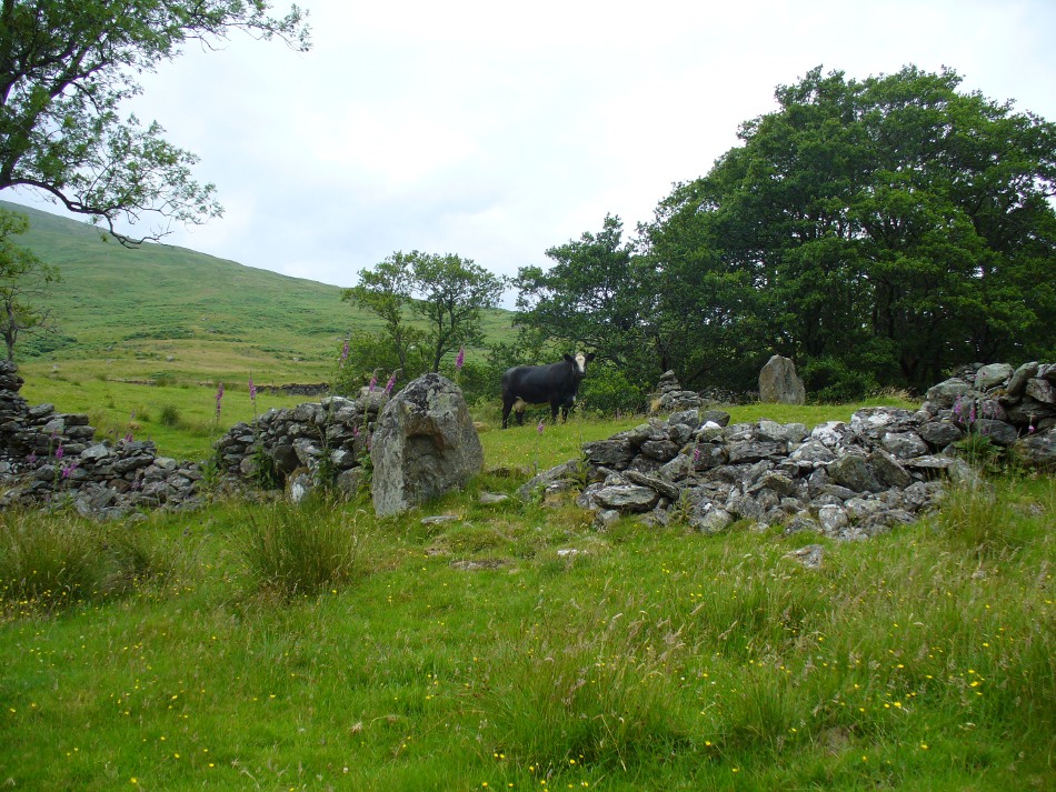
From Killin, travel down Glen Lochay, past Stag Cottage or Duncroisk and over the shallow river of Allt Dhun Croisg. If you’re in a car you can park up a 100 yards past the river bridge and walk up the track from here. After a 10 minute walk, above the trees you come to the derelict village of Tirai* where, until recently, you were greeted by a tall totem-pole of a gnarled tree (it was superb!) which is now Earth-lain, and a fine view of the evolving hills. Here amidst the ruins we also find a standing stone or two.
Archaeology & History
The village of Tirai was deserted sometime in the 19th century (due to the disgusting clearances of the English), but at least two standing stones still live amidst its ruins. The tallest is nearly four-feet tall in the middle of the grassy patch and is much used by grateful cattle to rub themselves against when midges and horseflies drive them mad! The Scottish Royal Commission lads reckon the megaliths here are,
“possibly a survivor of a stone circle as a similar stone is used nearby as a gate-post to an enclosure and several other large stones have been incorporated in the walls of the surrounding buildings.”
This may well be so – but it is equally possible that these are merely the remains of standing stones which once stood along this ridge and which were taken for use in the village.
One of the Tirai standing stones
Of the remaining standing stones in this idyllic setting – the Royal Commission fellas counted possibly four of ’em – all are roughly the same size, between 3 and 4 feet high. Johnstone & Wood (1996) also think the stones here may once have related to a prehistoric cairn in the village.
This is an utterly beautiful arena, even in the heights of winter. The village sits on the rear slopes behind the old cailleach, and there are plenty of cup-and-ring carvings, both known and unknown scattering the rocks and nearby hills. The curious Duncroisk Crosses carving is just visible from here, on the other side of the rocky gorge. Lost tales and lost sites abound here also. I did sit and wonder though… Considering that the villagers here left the old standing stones in place until very recent centuries at the heart of their hamlet, what uses did they make of it, or what tales did it speak? Or had the purge of the Church already taken its toll…?
References:
Gillies, William A., In Famed Breadalbane, Munro Press: Perth 1938.
Johnstone, A.S.K. & Wood, J.S., ‘An Archaeological Field Survey of Deserted Townships at Tirai, Glen Lochay, Killin,’ Association of Certificated Field Archaeologists (Glasgow University) Occasional Paper no 9 (1996).
* The place-name Tirai means ‘land of good luck or joy,’ which truly speaks well of its spirit and setting to me.
Settlements (destroyed): OS Grid Reference – SX 677 653
Archaeology & History
Prior to the submergence of one of the many prehistoric settlements in and around the waters of the Avon Reservoir, excavation work was carried out by Lady Aileen Fox between 1954 and 1956 on behalf of the Ministry of Works. The excavation notes in the Proceedings of the Prehistoric Society for 1957 told what Lady Fox and her fellow archaeologists found at the site that was due to be submerged:
“The walled enclosure of 2½ acres contained nine huts from 15-20 feet in diameter and three pens built against the outer wall. The huts were roofed in the same way as those as Kestor, having a central post and a ring of six or seven uprights supporting the main rafters. Part of the settlement was incorporated into a medieval farmstead, but the prehistoric occupation proved to be from the local Late Bronze Age.”
Since that report, a number of other prehistoric settlement sites have been found on the surrounding moorland heights (as a quick look at the OS-map clearly shows). Obviously a very busy place in ancient days!
References:
Clark, J.G.D. (ed.), “Notes on Excavations in Eire, England, Northern Ireland, Scotland and Wales during 1956,” in Proceedings of the Prehistoric Society, volume 23, 1957.