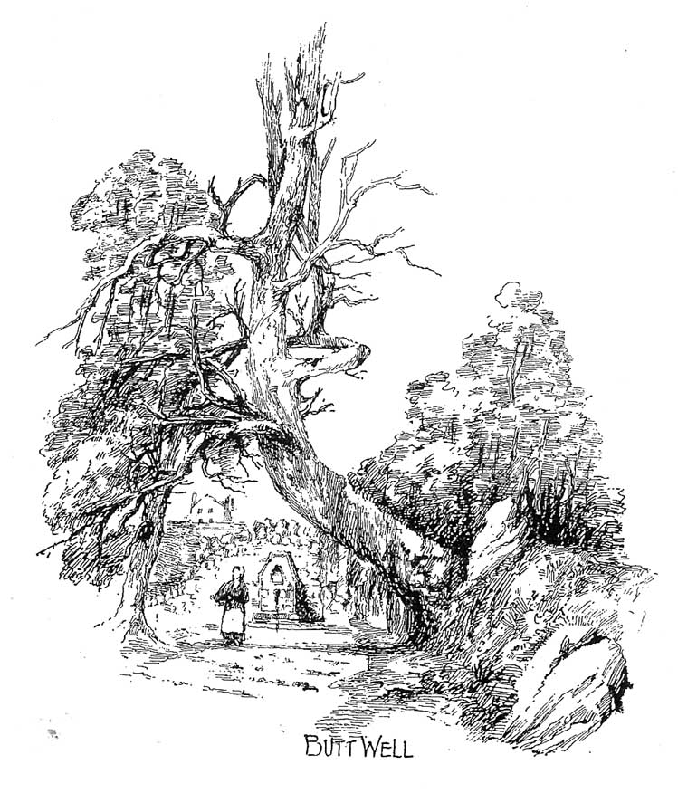
Said by John Allan (1907) to be “at the base of the Brandy Hill, about 210 yards west from the parish church,” to get to it from the town centre Stirling Arcade, go across and along the Corn Exchange Road and as it goes down the slope, take the path that leads into the trees on your right-hand side. Follow this path along to the bottom of the woods. Once on the level at the bottom, walk on the path in the direction of Stirling Castle and eventually you’ll reach the fancy walling with the dried-up well right in front of you!
Archaeology & History
This much-neglected site got its name from there being a number of archery shooting targets, or butts, which used to be erected in the fields immediately below this once popular drinking spot. Although the Stirling historian J.S. Fleming (1898) could find no definitive records of the place as a holy or healing well, he told how,
“The copious spring arising in the centre of the rock on which Stirling Town and Castle are built, must have been extensively used during the Royal occupation of the Castle for watering the horses engaged in hunting in the Park…and it must also have been the source from whence the canal or ornamental waters and fountains in the ancient pleasure-grounds of the King’s Knot were supplied, the fall being amply sufficient for the rise to a considerable height of the latter… The Well had at one time a railing surroundings its then open trough, the marks of the lead used in grouting the rails remaining visible until the last alteration.”
The waters emerging in the field belowThe Butt Well
Early accounts of the Butt Well are few and far between. Ronald James (1899) found it to have been known in earlier centuries as the Spout Well in 1582, but additional descriptions of the place are scant. The well is not included in the surveys of either MacKinlay (1893) nor the Morris’ (1981), though John Allan (1907) thinks that this site was a “congenial retreat” where “the bard of the chief” would gain insight. The remains of walling behind the old well he thought may have been the ancient remains of an old hermitage of sorts, but there’s little evidence to prove this. Today, although dried-up, the site appears much it as did when Fleming described it:
“The Well has had the old wall — formed of granite boulders — rebuilt and cemented, and a rustic ornamental freestone front put on where the spout is inserted, but its stone seat for invalids and other surroundings remains as they were forty years ago. The Well formed the termination of the early morning walk of the town’s folk for a draught of its cold water, and was at a late period used by the wives and washerwomen of Stirling for washing their clothes, which were then bleached on the green sward lying below the Well, the tenant of the park making a charge according to the extent of the washing.”
If you go behind the walling here you’ll notice a small flow of water which emerges into the field below. The waters from here, although only a trickle, are still cold, fine and refreshing.
References:
Allan, John, The Days of the Monasteries and Latter Days of Stirling, Stirling 1907.
Fleming, J.S., Old Nooks of Stirling, Delineated and Described, Munro & Jamieson: Stirling 1898.
Ronald, James, Landmarks of Old Stirling, Eneas MacKay: Stirling 1899.
The ancient and once sacred water source was described in local place-names such as Holywell strete and Holywellbrugge from the 13th Century onwards; yet despite it being at the heart of one of the cradles of the English church, there are only scant accounts of the legendary well down the centuries. The most detailed essay on this site was written by Tony Haynes (1986) in the specialist holy well journal, Source, more than 20 years ago. Haynes tells as much as it known of the site, saying:
“Late in the seventeenth century, when John Churchill, future Duke of Marlborough, pulled down his wife’s house and built a new mansion in the middle of Holywell Hill, thus creating a major diversion, the Holy Well was a feature of his terraced gardens. Maps of the period show the site of the well to be a focal point of his lawns.
“In 1815, Shaw’s guide to the town states, ‘The holy-well is still held in some esteem for its purity and salubrious qualities’. The Duke’s residence later became the property of the Earl Spencers. It eventually fell into ruin and was demolished in 1837, and the original route of Holywell Hill was restored, no doubt much to the relief of contemporary coach and wagon drivers. After this time, the grounds were left to decay. Ten years later little remained of the gardens but a fishpond and the Duke’s ‘canal’ marking the original course of the River Ver.
“Of the Holy Well, in his History of St Albans published in 1893, Charles Ashdowne laments that: “It is now remembered only as a muddy depression, sheltered by the remains of a dilapidated wall and a mournful specimen of blackthorn.” Eventually the land was acquired by the St Albans School for Boys as a playing field. “The exigencies of athleticism necessitated the ground being levelled and turfed over,” Ashdown continues, “and it is much regretted that there is nothing to mark the site of what was essentially one of the most ancient of English Holy Wells.”
“This is confirmed by a Miss Lightfoot of Holywell Hill. In 1960, when she was 85, she wrote in a letter to Hertfordshire Countryside magazine: ‘I remember the well quite well, for as a child I often went round it. It was surrounded by a fence, inside was a tree, water and weeds – not very inviting.’
“The ‘Old boys’ of St Albans School recall, about fifty years ago, there being a concrete slab at one end of their football pitch which they knew as the site of the well. Their playing field fell into disuse in the 1960’s, but the exact site of the well was lost long before this.”
Naff all is visible here nowadays, apart from some concrete square bitta brickwork that betrays any sense whatsoever of a once sacred site. Very disappointing indeed…..
Folklore
As with a great many British holy wells, this all-but-forgotten site was named after one of the early christian martyrs — in this case from as early as the late 3rd century AD. A number of early folklore texts describe St. Albans story, with Vernon Brelsford (1958) telling:
“Tradition states that on his way to execution he walked up a neighbouring hill where he prayed for water to quench his thirst, whereupon a fountain of water sprang up under his feet. Here he was beheaded on June 23, AD 303.”
This date indicates the site probably replaced an earlier, heathen midsummer solstice custom at, or near this spot. Another tale tells that when St. Alban had been executed, the saint’s head rolled down the hill and into the waters of the well below. Mr Haynes (1986) described other early folklore which seems to relate to St. Alban’s Well, telling:
“An early reference to the well can be found in the writings of Brompton who lived in the time of Richard II. He recorded that the father of King Arthur, a British Prince, was severely wounded in the battles with the Saxons:
‘A long time he lay confined to his bed until at length he was cured by resorting to a well or spring not far distant from the city. at that time reputed to be salubrious; and for that reason, and for the cures thereby performed, esteemed holy; and blessed in a peculiar manner with the flavour of Heaven.’
“Two devout sisters built a shelter near the well. They served the weary pilgrims who trudged up the steep hill towards Alban’s shrine in the abbey, by dipping, or ‘sopping’ their bread in the holy water and offering it to the thirsty travellers. Hence was founded Sopwell Priory, nearby.”
References:
Brelsford, Vernon, Superstitious Survivals, Centaur Press: London 1958.
Gover, J.E.B., et al, The Place-Names of Hertfordshire, Cambridge University Press 1938.
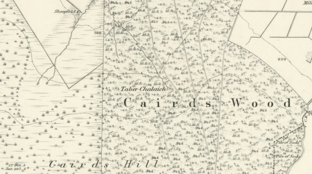
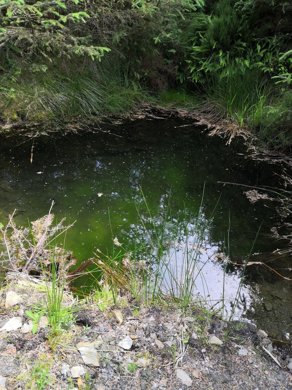
Described on the earliest OS-map of the region as Taber Chalaich, this great “well of the old woman, witch, or hag” is found on the northern slopes of Cairds Hill, amidst increasingly dense woodland up the top of the stream which ebbs and flows in strength (depending on the weather). A water source dedicated to the prima mater Herself — i.e., the heathen pre-Celtic female creation deity par excellence — it was once of considerable repute locally and was known to cure various ailments. It was described by Ruth and Frank Morris (1981) as being,
“the scene of a pagan ceremony in which the Earth Mother in her old woman phase bathed at the well and returned as a young maiden.”
Tobar na Cailleach (21st Century Pict)
This tells us that rites were enacted here around Imbolc (February 1-2). The well can still be found running. A visit to the site in July 2025 by Pol Anndrais found that “the East Side of the pool has been dug out and the rocks used to dam the outlet. The pool is roughly square, about 2 metres across. The inlet is over natural rock visible beneath the surface, the pool is about 1 metres deep and reasonably clear with pond skaters and diving bettles, (but) no visible offerings…”
On the hill at the top we find remains of old tombs (mistakenly ascribed by Mr & Mrs Morris as ‘stone circles’), some of which may have had some mythic relationship with this legendary water source. If anyone has any further information about the folklore or history of this site, we’d love to know about it.
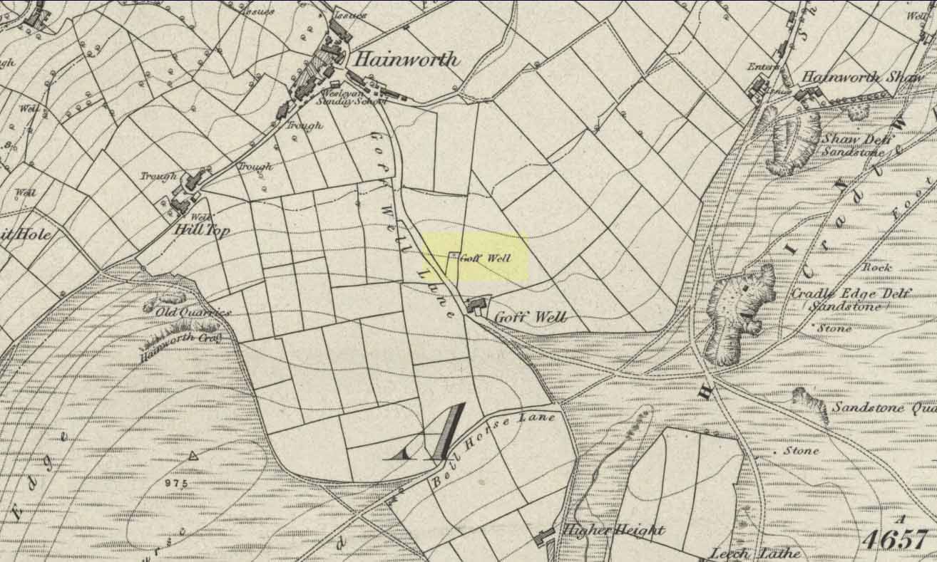
Various ways here. From Keighley, go up the A629 Halifax Road, first left after the Ingrow West train station, uphill; then turn right, and up the long, cobbled, zizaggy road past the little hamlet of Hainworth and uphill till you reach the solitary farmhouse of Goff Well Farm (where its friendly owners can sell you organic fresh eggs!). It’s the field just before here on your left (if you reach the Guide Inn pub further uphill by the crossroads, you’ve gone too far). Alternatively start at the Guide Inn pub and walk across the road and downhill till you reach the farm. It’s in the first field on the right just past it.
Archaeology & History
Little is known about the history of this water source. The first description of it seems to be in 1852. Harry Speight (1898) mentions it briefly when he talks about the holy wells of the locale, saying simply:
“Goff Well, close to the road on Harden Moor leading to Hainworth, has given name to a neighbouring farm, but the purpose or virtues of this water are not now known.”
Goff Well on 1852 OS-map
Today the well is much overgrown and in need of attention. It’s near the bottom corner of the field where the larger of the elder tree grows (the witch’s tree par excellence) and could do with being cleaned out. When the owner of Goff Well Farm, Barry, took us to see the site, the waters couldn’t be seen but we could hear the water running clearly just beneath the surface, so it just needs a few hours work to bring it back into life. Twouldst do the land and the genius loci the world of good!
The very name of the well is something of an anomaly. There are several possibilities and we (as yet) cannot say which is the more likely derivation. We know in northern dialect that Goff is a simpleton or fool, and although we can apply that definition in some cases, it’s unlikely to apply here. If we could ascertain there was ever an apple tree growing here, the mystery would be solved, as a goff was an old word used for the common apple. In West Yorkshire dialect the word was also used to denote “a hammer worked by water-power”; aswell as it being a corrupted form of the word ‘God.’ Take your pick!
Folklore
The early Victorian historian William Keighley (1858) thought Goff Well was named after a long-forgotten hermit called Goff who, at some time in the past, gave his name to the old hamlet of Hermit Hole, a half-mile downhill from this water source. Mr Keighley wrote:
“On the skirts of Harden Moor is a farmhouse known by the name of Goff Well; and as goff is said to be the Danish word for red, it would probably be no great stretch of the imagination to suppose that the hermit was so named on account of his red hair, and the spring or well designated after him from the frequency and sanctimonious nature of his visits.”
But this is pure supposition on Keighley’s part — nice idea though it is! The only tangible piece of folklore we have is that the well “was a famous resort of gypsies before the moor was enclosed in 1861.” (Speight 1898)
References:
Keighley, William, Keighley, Past and Present, Arthur Hall: London 1858.
Speight, Harry, Chronicles and Stories of Old Bingley, Elliott Stock: London 1898.
Very little is known about this forgotten heathen water source. It was described in some notes attached on a piece of paper accompanying John Warburton’s description of Lee Hall and its surroundings. The notes were first printed in an early edition of Archaeologia Aeliana and subsquently included in Binnall & Dodds’ (1942) fine survey on the holy wells of the region. It’s exact whereabouts appears to be lost, but it may be either the small pool across from the present Hall, or a small spring found in the edge of the small copse of trees just east of Lee Hall Farm. Does anyone know?
Folklore
Written verbatim in that dyslexic olde english beloved of antiquarians like misself, the only piece of folklore said of this spring of water told:
“At the Lee hall an exclent spring, the vertue is such that if the lady of the Hall dip aney children that have the rickets or any other groone destemper, it is either a speedy cure of death. The maner and form is as followeth: The days of dipping are on Whitsunday Even, on Midsumer Even, on Saint Peeter’s Even. They must bee dipt in the well before the sun rise and in the River Tine after the sun bee sett: then the shift taken from the child and thrown into the river and if it swim…child liveth, but if it sink dyeth.”
The latter sentence echoing the crazy folklore of the christians to identify witches in bygone days!
References:
Binnall, P.B.G. & Dodds, M. Hope, ‘Holy Wells in Northumberland and Durham,’ in Proceedings of the Society of Antiquaries of Newcastle-upon-Tyne (4th Series), 10:1, July 1942.
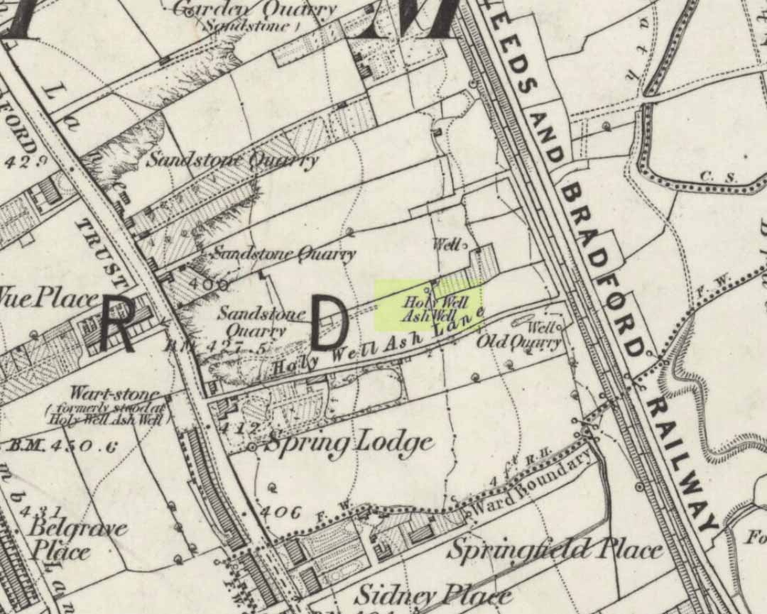
Holy Well (destroyed): OS Grid Reference – SE 15942 34208
Also Known as:
Ash Well
Holy Well Ash Well
Pin Well
Archaeology & History
Holy Well Ash on 1852 map
Either right next to, or perhaps now beneath Bradford City’s Valley Parade football ground, was once a very important sacred well site. Known as the Holy Ash Well and variants thereof, this healing spring was of considerable renown to people all around Bradford district in bygone days. The site was illustrated on the 1852 OS map, and there was also a sacred stone adjacent to the well known as the Wart or Pin Stone, which had some animistic healing properties related the waters.
The old well was described by local historian Abraham Holroyd (1873) who said that:
“In Manningham Lane there is a fine well, in old deeds called Hellywell, i.e., holy well, in a field now called Halliwell Ash, now a stone quarry… Near this is the ancient Pin Stone.”
A few years later, in Robert Charles Hope’s (1893) monumental study, he described how,
“This holy well, not far from Manningham Lane, probably derived its name from having at some time been dedicated to some saint. The inhabitants of Bradford were wont in ancient times to resort on Sundays to these wells as a common place of meeting, to drink of the waters and partake of their preternatural virtues.”
Which was another was of saying that he didn’t really know too much about the place!
The Bradford historian William Preston (1933) described this site in one of his early essays, where he informed us that local people knew the accompanying rock hereby as the Ash Stone, due to its proximity and ritual relationship to a great old ash tree (Fraxinus excelsior) that grew next to the well. The mythic history of this particular tree should not be understated: it was a Creation deity par excellence in northern and Viking myths, but whatever old tales and power might once have been had here, in Bradford, they’ve long since been forgotten. But it was the industrial historian William Cudworth (1896) who told the most of this all-but forgotten site, saying:
“On the sloping ground between Belle Vue and the Midland Railway there once existed a spring of water, supposed to have preternatural virtues. The name it bore within present recollection is probably a corruption of Holy-well. The holy wells of England as elsewhere had not all the same virtues attached to them. Some were blessed if used for baptisms, to others were attributed curative properties, especially for sore or weak eyes, while others were supposed to possess mystical powers, insomuch as any article dipped in them became charms or safeguards against witchery. Any traditions associated with the spring at Halliwell (or Holywell) Ash are lost, but certainly in the early part of the present century the place was a favourite resort of the townspeople on Sundays.
“The derivation of the name is doubtful. In the survey of 1638 a close called ” Helliwell Ash” is mentioned as containing 2a. 3r. 26p., but without any indication as to its locality. The spelling of the name is of little moment. Mr. James, in his “History of Bradford,” states that he had seen the place referred to in old deeds as “Helly-well.” By his will, dated May, 1685, Thomas Lister, of Manningham, devised to his two daughters, Juliana Lambrecht and Elizabeth Stapleton, equal shares in two closes of land called “Holywell Ash” and ” Delf Close,” besides other lands in Manningham. In the will disposing of the possessions of Juliana Lambrecht, her moiety of “Holywell Esh” was bequeathed to Francis Stapleton, her nephew. In due course the lands in question were inherited by Francis Sharp Bridges, and have latterly belonged to Sir Francis Sharp Powell, M.P., in whose writings the form of spelling is given as ” Halliwell Ash.”
“Upon the ground in question there used to be a fine well of water issuing out of the higher ground, to which tradition assigned healing virtues. Might not the name of “holy” come from this circumstance? Sufficient importance attaches to the tradition, however, to have led the farmers of the recent ordnance plan of Manningham to preserve the name, although the widening of the Midland Railway below Thorncliffe Terrace has almost obliterated the site.”
A more recent updated overview of the site was written by one of my old school-mates, Dave Pendleton (1997), who said of the place:
“Prior to 1886 the only feature of any real note in the Valley Parade environs was a holy well that emerged near the corner of the football grounds Midland Road and Bradford End stands; hence the road Holywell Ash Lane. Today the site of the well is covered by the football pitch.
Only the road name survives as a reminder of what was apparently one of the district’s foremost attractions. On Sundays and holidays people would gather to take the waters and leave pins, coins, rags and food as offerings to the spirit that resided in the waters.
Accounts suggest that the well was covered and had a great ash tree standing over it (hence ‘holy ash’). There was also a standing stone called the wart stone of unknown antiquity. The stone had a carved depression that collected water. It was believed that the water was a miraculous cure for warts. Indeed, as early as 1638 the Holy Well had been credited with healing powers.
The well suffered a decline in popularity during the late nineteenth century and its keepers resorted to importing sulphur water from Harrogate, which they sold for a half penny per cup. The well disappeared under the Valley Parade pitch during the summer of 1886 and the wart stone was moved to the top of Holywell Ash Lane – which then ran straight up to Manningham Lane. The stone was still there as late as 1911 but thereafter it seems to have disappeared into the mists of time.”
A night-club adjacent to the Valley Parade football ground—called Bibby’s—was said to have had an old well in its cellar, which the owner of the place, Mr Pearl Gladstone Minott, said was ‘haunted’.
Unfortunately I’ve not been able to find any old photos or drawings of this lost holy well – though I imagine that some local, somewhere must be able to help us out with this one. Surely there’s more of this site hidden away somewhere….?
References:
Bennett, Paul, The Old Stones of Elmet, Capall Bann: Milverton 2001.
Cudworth, William, Manningham, Heaton and Allerton, W. Cudworth: Bradford 1896.
Holy Well (destroyed): OS Grid Reference – SE 295 329
Archaeology & History
In the Holbeck area of Leeds, one of the three spa wells was previously patronised to this mythical saint, whose wells profuse in this part of the world. St. Helen’s Well (later becoming the Holbeck Spa Well) was found at the appropriately named St. Helens Bridge. Ralph Thoresby (1715) wrote of the place: a supposed medicinal holy well, it previously had a chapel by it, of which no trace is seen today. John Mayhall (1860) also mentioned this “medicinal well,” but told little more. It was Andrea Smith (1982), more than a century later, who wrote the most about the place:
“In connection with the well by St.Helen’s Bridge, Holbeck, (Thoresby) refers to “another ancient fabrik called St. Helen’s,” but there is a difficulty in deciding exactly what he means by ancient; it is taken here as meaning more than two hundred years old. This suggests, then, that by St. Helen’s Bridge there was once a well and chapel which gave rise to the dedication and which was probably a Medieval foundation, considering the popularity of St. Helen at that time.”
Both of these sites have long since disappeared. The well eventually became known as a local Spa Well, and was found to possess a high sulphur content.
References:
Mayhall, John, The Annals of Yorkshire, Joseph Johnson: Leeds 1860.
Smith, Andrea, ‘Holy Wells Around Leeds, Bradford & Pontefract,’ in Wakefield Historical Journal 9, 1982.
Thoresby, Ralph, Ducatus Leodiensis: or the Topography of the Ancient and Populous Town and Parish of Leedes, Robinson & Holdsworth: Leeds 1816.
To be found somewhere between the two outer embankments on the southern side of the legendary Grianan of Aileach, this — one of many St. Patrick’s Wells in Ireland — is typically attributed with healing properties. It was described in Henry Morris’ (1938) survey (amongst others) as being the place where, in the 5th century when St. Patrick came here, Prince Eoghan was baptised and thereafter turned his back on the heathen gods of his ancestors for this new christian cult which was just growing at that time. (‘Eoghan,’ pronounced owen) Thereafter other people were baptised by the waters from here, which in ancient days would have been the water supplies for those at the Grianan.
Henry Swan (1938) told that in previous times there once grew a legendary tree by this well, into which pilgrims inserted pins and other artefacts as offerings and to make wishes to the spirit of the waters. A similar thing (with the same underlying mythic structure) occurred at the tree and holy well of Loch Maree.
Up until quite recently, the well was very overgrown and in a condition that Rear Admiral Pascual o’ Dogherty called “disgusting.” He called for renovation work and action to bring this ancient site back into good health, and thankfully, as a result of the man’s proclamations, St. Patrick’s Well here has been brought back into a good state of life. Excellent stuff good sir!
References:
Lacy, Brian, Archaeological Survey of County Donegal, DCC: Lifford 1983.
Morris, Henry, ‘The Holy Wells of Inishowen,’ in H.P. Swan’s Book of Inishowen, Buncrana 1938.
o’ Muirgheasa, Enri, ‘The Holy Wells of Donegal,’ in Béaloideas 6:2, 1936.
Swan, Harry Percival, The Book of Inishowen, William Doherty: Buncrana 1938.
Easy to locate: it’s just by the roadside on the left-hand side of the road, Jinny Lane, coming out of the village, just after the last house where the field begins.
Archaeology & History
Nowt to write home about, as they say. The waters here trickle from the earth into an old stone trough — but they don’t look too appetizing (even I didn’t have a drink, which is something of a rarity!). Its the folktale accompanying this little site, giving a distinct hint of some heathen past, that I found intriguing.
Folklore
Here was once the spirit of a woman called Jinny – who gave her name to the road it’s on – that wandered betwixt the well and an old stone, once found further up the hillside (after a bitta digging, we found the remains of the old stone, previously an authentic monolith). It was said that if you wandered along the road on certain moonlit nights, her spirit would chase you. To make matters worse, the ghost was a headless one!
Jinny’s spirit originally resided, peacefully, in the broken old stone atop of the hill. At a certain time of the year, the spirit of the stone would venture downhill to drink from the waters here (much as we find at Rollright and other places). But one day a xtian priest came along and, because of its heathen association, broke the old stone in half and cursed the spirit which roamed between the sites. Thereafter, Jinny’s ghost wandered in torment, with her head hacked off, scaring people half to death when they saw her. And so, another priest was eventually called who, to the satisfaction of local people, eventually put Jinny’s ghost to rest, as they say. It seems to have been a successful ritual, as no-one has reporting seeing the headless ghost for many a long year.
References:
Byrne, Clifford H., Newchurch-in-Pendle: Folklore, Fact and Fiction, Marsden Antiquarians: Nelson 1982.
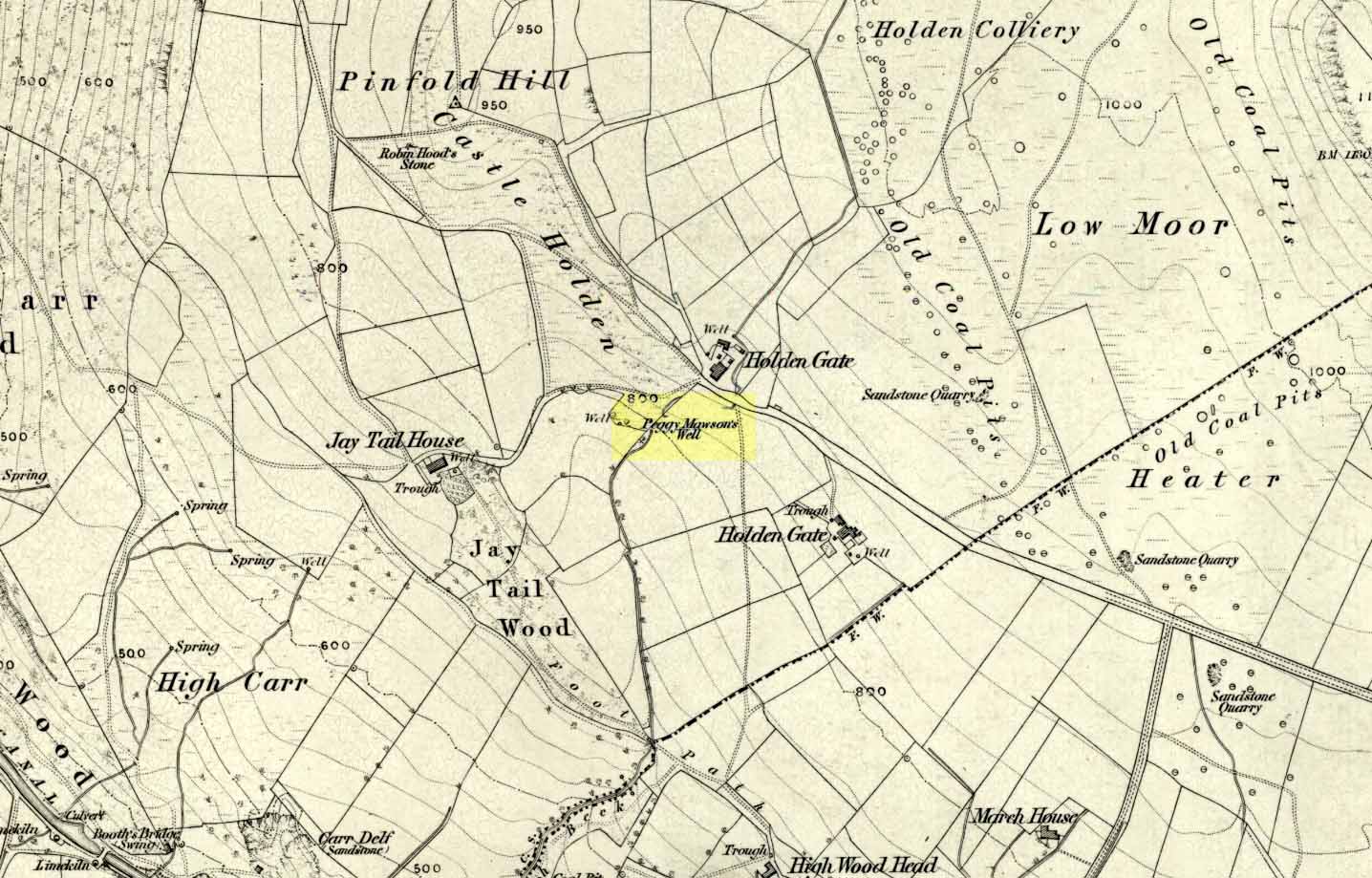
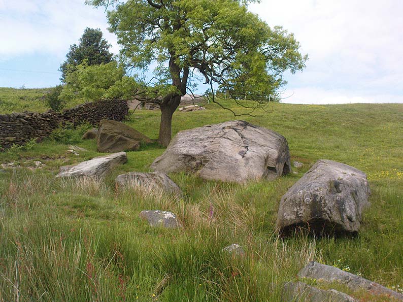
From Riddlesden, take the road up to the moorland and Rivock Edge. When you reach the top (Silsden Road), turn left. Go on for about 600 yards till you reach the lovely tree-hidden old cottages of Holden Gate, on your right. Stop — and walk down the footpath opposite from here. As the wall goes down, you’ll notice a stream in the next field to your left, emerging from a clump of large rocks. That’s it! (there’s a footpath in the next field from the roadside)
Archaeology & History
Shown on the first OS-map as ‘Peggy Mawson’s Well,’ little else seems to known of this place; though it obviously got its name after the local lady, Peggy Mawson. I can find no further information about this lady, nor why the site was named after her. Any help here would be hugely appreciated!
Peggy Mawson’s Well – now drained-off through pipes
Sadly the waters from beneath the rocks have been channeled into a couple of pipes and the well no longer runs. All that’s left is a small boggy region just in front of the boulders. You have to walk about 100 yards further down the field where the water emerges from a modern pipe. It doesn’t taste as nice as it originally did when coming straight from the ground, but it’s still quite drinkable (certainly beats any of the chlorinated stuff* that customers are forced to pay for, whether we want it or not – and most people don’t want it).
Folklore
This site has acquired modern folklore, but sadly no early traditions have been found. Whelan & Taylor (1989) thought that Peggy Well’s “dedication suggests a connection with St. Margaret,” which unfortunately isn’t the case. Several years later another writer, Val Shepherd (1994), spun the speculation even further, not checking the historical background to the site, and thought that “the well’s name may be derived from the water spirit, ‘Peg,’ who gave her name to other wells.” Sadly neither idea holds any sway.
References:
Shepherd, Val, Historic Wells in and Around Bradford, HOAP: Loughborough 1994.
Whelan, Edna & Taylor, Ian, Yorkshire Holy Wells and Sacred Springs, Northern Lights: Pocklington 1989.
* Anyone know about this: surely because the water companies chlorinate and add other undesirable toxins into our tap water, what we’re actually drinking is a very weak solution and not actually water. Isn’t that a trading standards violation?