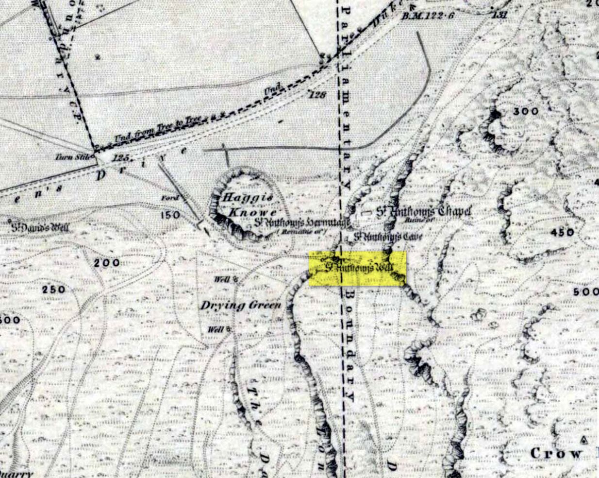
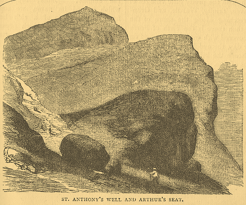
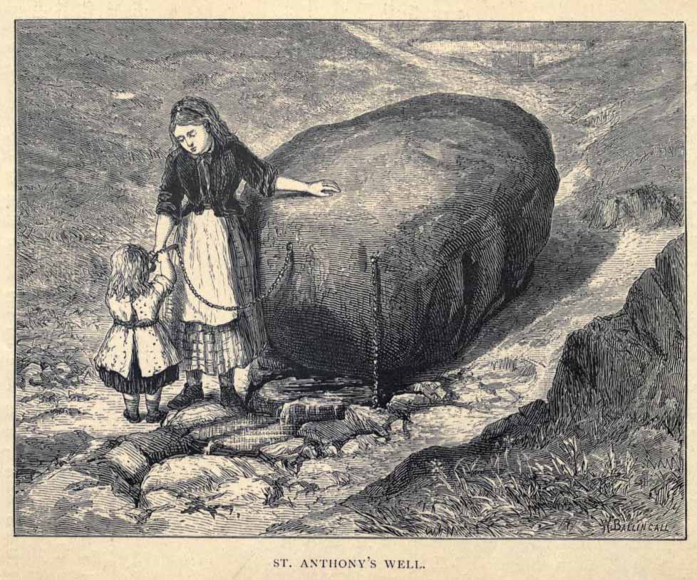
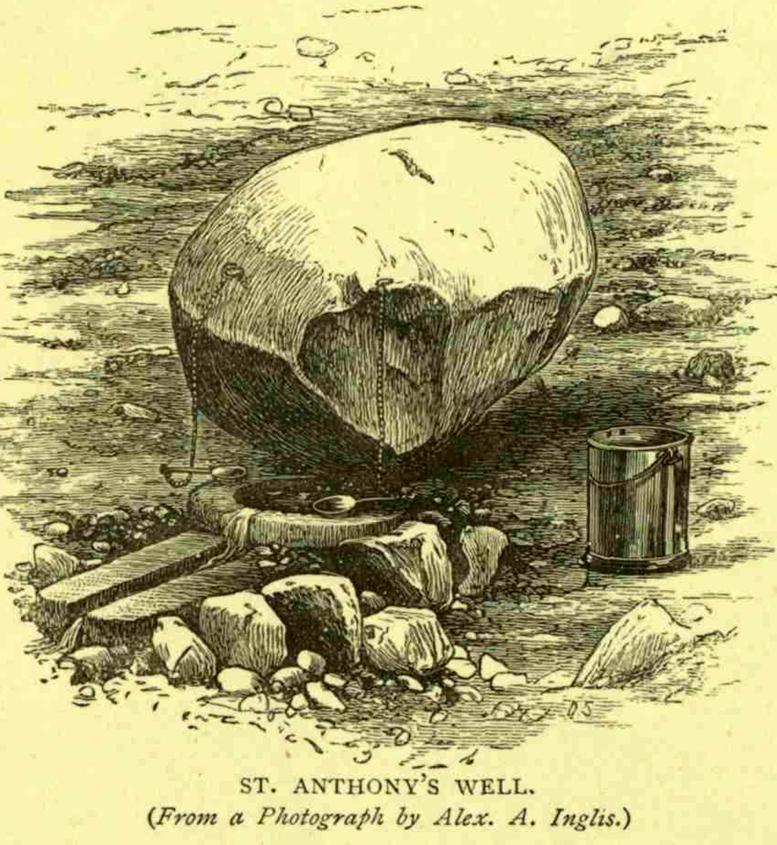
Not too difficult to find really. Get to the northern part of the road which encircles Arthur’s Seat and when you get to St. Margaret’s Loch (near St. Margaret’s Well), look up the slopes on your right where you see the remains of St. Anthony’s Chapel. You need to head up the footpath here until you reach a large-ish ovoid boulder, with a small circular trough into which the waters run (the drawing of the place here, with the rock in the lower-left, just in front of the fella walking towards it, is just right!). You’re here!
Archaeology & History
St Anthony’s Well, Arthurs Seat
Tradition tells that the remains of St. Anthony’s Chapel was built on the northern ridge by Arthur’s Seat, “mainly for guardianship of the holy well named after the saint” — which sounds rather like the christianization story of a heathen site. Francis Grose (1797) told that “this situation was undoubtedly chosen with an intention of attracting the notice of seamen coming up that Frith; who, in cases of danger, might be induced to make vows to its tutelar saint.” If this was the case, it sounds even more like a site that had prior heathen associations. Grose also told us that just a short distance from the chapel, were the remains of an old hermitage:
“It was partly of masonry worked upon the natural rock. At the east end there are still two niches remaining; in one of which formerly stood a skull, a book, an hour-glass, and a lamp, which, with a mat for a bed, made the general furniture of the hermitage.”
I like the sound of the place! Just up my street! Little other archaeological info has emerged from this tiny spot — but the healing waters of the well would obviously have been of importance to our indigenous inhabitants (anyone who wants to think otherwise is simply a bit dim!) as there is a wealth of archaeological sites and relics all round Arthur’s Seat.
Folklore
A number of writers have described this old well, which has sun-lore, healing properties, and Beltane rites surrounding its past. Local people of all social classes frequented this ancient spring, particularly on that most favoured of heathen days, Beltane. The site was of considerable mythic importance with a certain order about it. As Hone (1839) said:
“…the poorer classes in Edinburgh poured forth at daybreak from street and lane to assemble on Arthur’s Seat to see the sun rise on May-morning. Bagpipes and other musical intruments enlivened the scene, nor were refreshments forgotten. About six o’ clock a crowd of citizens of the wealthier class made their appearance, while the majority of the first-comers returned to the town. At nine o’ clock the hill was practically deserted.”
Another early account describing St. Anthony’s Well is from an article in the great PSAS journal of 1883. Here, J.R. Walker wrote:
St Anthonys Well
To an incident which showed that the faith and belief in the healing virtues of the wells is still strong, the writer was but a few months ago an eye-witness. While walking in the Queen’s Park about sunset, I casually passed St. Anthony’s Well, and had my attention attracted by the number of people about it, all simply quenching their thirst, some possibly with a dim idea that they would reap some benefit from the draught. Standing a little apart, however, and evidently patiently waiting a favourable moment to present itself for their purpose, was a group of four. Feeling somewhat curious as to their intention, I quietly kept myself in the back ground, and by and by was rewarded. The crowd departed, and the group came forward, consisting of two old women, a younger woman of about thirty, and a pale, sickly-looking girl — a child of three or four years old. Producing cups from their pockets, the old women dipped them in the pool, filled them, and drank the contents. A full cup was then presented to the younger woman, and another to the child. Then one of the old women produced a long linen bandage, dipped it in the water, wrung it, dipped it in again, and then wound it round the child’s head, covering the eyes, the youngest woman, evidently the mother of the child, carefully observing the operation, and weeping gently all the time. The other old woman not engaged in this work was carefully filling a clear flat glass bottle with the water, evidently for future use. Then, after the principal operators had looked at each other with an earnest and half solemn sort of look, the party wended its way carefully down the hill
Earlier still we find more lore of the place in Wilson’s Edinburgh [1848] where he told:
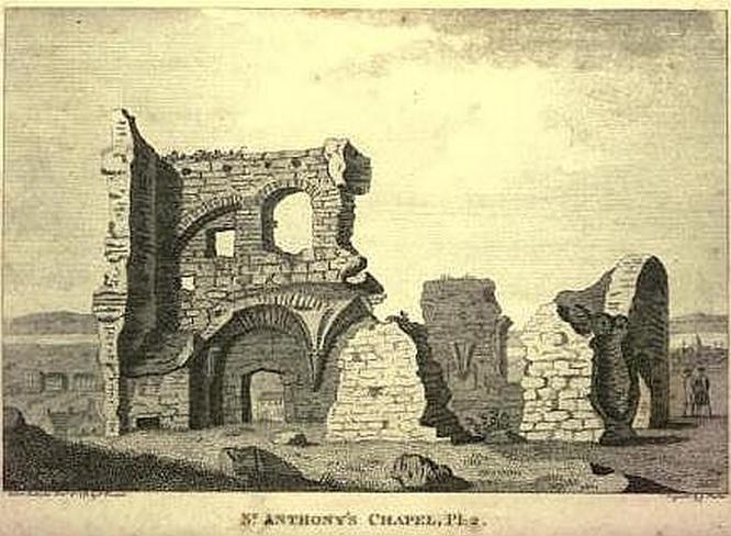
St Anthony’s Chapel 1785
“The ancient Hermitage and Chapel of St. Anthony, underneath the hangings of Arthur’s Seat, are velieved to have formed a dependency of the preceptory at Leith, and to have been placed there, to catch the seaman’s eyes as he entered the Firth, or departed on some long and perilous voyage; when his voews and offerings would be most freely made to the patron saint, and the hermit who ministered at his altar. No record, however, now remains to add to the tradition of its dedication to St. Anthony; but the silver stream, celebrated in the plaintive old song, ‘O waly, waly, up yon bank,’ still wells clearly forth at the foot of the rock, filling the little basin of St. Anthony’s Well, and rippling pleasantly through the long grass into the lower valley.”
Votive offerings made here eventually turned the waters into a simply wishing well for incomers, even in Victorian times (oh how the locals must have hated such trangression…). The great Scottish holy wells writer J.M. MacKinlay (1893) told in his day the tale of,
“a little girl from Aberdeenshire, when on a visit to Edinburgh, made trial of the sacred spring. She was cautioned not to tell anyone what her wish was, else the charm would have no effect. On her return home however, her eagerness to know whether the wish had…been fulfilled, quite overcame her ability to keep the secret. Her first words were, ‘Has the pony come?’ St. Anthony must have been in good humour with the child, for he provided the pony, thus evidently condoning the breach of silence in deference to her youth.”
In the middle of the 20th century, the great folklorist F.M. MacNeill (1959) wrote:
“Even in Edinburgh, little bands of the faithful may be seen making their way through the King’s Park to Arthur’s Seat, and, as in the eighteenth century:
On May-Day, in a fairy ring,
We’ve seen them round St. Anton’s spring,
Frae grass the caller dew-drops wring,
To weet their een,
And water clear as crystal spring,
To synd them clean.”
And when Ruth and Frank Morris (1982) got round to their excellent survey, they found that this old well was still being used “by youths and maidens, who come to wash their faces with the dew on May Day mornings, a wish at St. Anthony’s being a part of the ritual.” But this final remark may have the simple prosaic coincidence of them observing people like I, when younger, who frolicked with girlfriends around May morning, in the grasses near the old well — though at the time I knew nothing about the old sacred waters on the slopes just above us!
Stone Circle (destroyed): OS Grid Reference – SE 748 282?
Archaeology & History
I’ve looked and looked for info on this seemingly lost site, but have found very little. It lent its name to the very woodland within, or on whose edges, it could once be found. First described as early as 1284 in the ‘Calendar of Patent Rolls’ – where is appeared as ‘Ringestainhirst‘ – and then in the Testamenta Eboracensia in 1391, it is mentioned several other times before falling into nothing but literary memory in the middle of the 19th century.
We don’t know for sure where the circle was located, though one Latin reference describes it in proximity to a hermitage once known as St. Mary Magdalen’s Chapel at Howden: “heremitae de Ryngstanhyrste.” The site would likely have been on the highest point in the locality, which may put it where the great church now stands, or perhaps on the more northern and western outskirts of the township. Are there any Howden historians reading this who might be able to throw a bit more light on the issue?
The great place-name authority A.H. Smith (1937) thought that the Ringstone Hurst (woodland) at Howden got its name from a “wood near the circular stone”; but modern etymologists would place a much greater likelihood that the woodland owed its name to the now lost stone circle that was once in this locality.
References:
Raine, James (ed.), Testamenta Eboracensia; or, Wills Registered at York, J.B. Nichols: London 1836.
Smith, A.H., The Place-Names of the East Riding of Yorkshire, Cambridge University Press 1937.
Various ways to get here, but I suppose the easist is by walking along the path just above the woods from the main A61 road, where there’s the junction turn-off to Wike. You have to walk perhaps 1000 yards until eventually, a couple of hundred yards up the slope to your left (south) you’ll see the boulder stuck in the field. You’re there!
Archaeology & History
The Grey Stone, Harewood
Described first by Cowling & Hartley in 1960, this multiple-ringed carving gives the distinct impression that it aint quite as old as our more traditional cup-and-rings on the moors west and north of here – but I s’ppose we’ll never know for sure. There isn’t a central cup to this concentric-ringed carving, which is quite unusual, and which is why I get the impression that it’s from a later archaeological period. However, saying that, there are several other faint cup-markings on the southwest and east-faces of the boulder (which I forgot to photograph when I was there – idiot that I am!). Boughey and Vickerman (2003) illustrate as many as 18 other cup-marks on the rock surface – which they list as stone 399 in their survey.
Although there seems to be no folklore attached to this isolated carving, rock-art authority Graeme Chappell noted how “the midwinter full moon set behind Almscliffe Crags at its extreme northerly setting point in Bronze Age times” from this Grey Stone.
The archaeologist S.A. Moorhouse (1981) also pointed out how some of the many Grey Stones (which usually means ‘a boundary stone’, sometimes very ancient ones) found in northern England, derive their name from the old word har, which “can also mean ‘grey, hoar,’ used to describe natural boulders, possibly with cup-and-ring markings” – just as we have here!
References:
Bennett, Paul, The Old Stones of Elmet, Capall Bann: Milverton 2001.
Boughey, Keith & Vickerman, E.A., Prehistoric Rock Art of the West Riding, WYAS: Wakefield 2003.
Cowling, E.T. & Hartley, C.E., ‘A Ring-Marked Rock: The Grey Stone,’ in YAJ 1960.
Moorhouse, S.A., ‘Boundaries,’ in Faull & Moorhouse’s West Yorkshire: An Archaeological Survey, volume 2, 1981.
Easy enough to find once you’ve actually got to Wycoller. By car, the only real way to get here is from Colne, through the village of Winewall, and along the Wycoller road, which runs to a dead end. Once here, the old packhorse bridge with these cup-marks on it can’t be missed!
A weird one this! On the famous packhorse bridge close to the old hall, four of the stones have cup-markings etched onto them. It seems that at least three of the carvings are archaic; with cups on one of the stones being somewhat deep and may actually be medieval. But we simply don’t know…. A short article describing them was in the Bradford Cartwright Hall Archaeology Bulletin (1962) where they were equally as puzzled about them. In 1979, J.A. Heginbottom described them in his survey on the prehistoric rock-art of upper Calderdale. It’s possible that the stones on which the cups were carved might have been taken from a prehistoric tomb on the edge of the moor further up the valley from here.
Folklore
Just next to this bridge is another, much older one, known locally as the Clapper or Druid’s Bridge which perhaps has some bearing on the curious cup-markings. Legend tells that this older construction was so called “because legend has it that it led to an amphitheatre where the druids held human sacrifices” – and the field just up from here (to the southwest) was known as the Dripping Stone Field. Hmmmmm…..
References:
Bentley, John, Portrait of Wycoller, Nelson Local History Society 1975.
Heginbottom, J.A., The Prehistoric Rock Art of Upper Calderdale, unpublished report: 1979.
Jackson, Sidney, ‘Cup-Marked Stones at Wycoller,’ in Cartwright Hall Archaeology Group Bulletin, October 1962.
Settlement (destroyed): OS Grid Reference – SJ 959 928
Archaeology & History
Known by this name – Werneth – since at least the 12th century, place-name masters Ekwall, Smith and others have tended to think the place derives from a hypothetical British word, *verno-, meaning alder trees – though I aint so sure misself.
It’s been difficult to ascertain the precise nature of this prehistoric arena. Many mesolithic flint finds and old stone axes have been found around the area, but it seems primarily to have developed into a neolithic and Bronze Age settlement and burial site. A number of cairns were once here, and both rounded and linear earthwork features occur in the area; but there’s been considerable disturbance in and around the site and without in-depth archaeo-surveillance, much remains hidden.
Along the A61 Harrogate-to-Harewood road, just below the roundabout where the A658 links up, is a small country road that turns towards the lovely village of Kirkby Overblow. If you’re in a car, park up wherever you can hereabouts (being careful of the locals!). Cross over onto the western-side of the A61 and walk along the small tree-lined field-edge until you find a spot to get over, where this stone stands.
Archaeology & History
It’s hard to suss out how many monoliths first stood here, but when William Grainge (1871) and Harry Speight (1903) described them, it was believed they had been uprooted in the 17th or 18th century. Although one of them has gone, thankfully the scarred remnant of one is still here.
Site number 168 in Old Stones of Elmet, one of the two standing stones that were described in parish boundary records of 1577 as “two stones standing in Walton Head Layne” can be found northeast of the village, along the ancient church way between Rigton and Kirkby. However, it is not as it once was! The boundary perambulation was redefined in 1767, when it was thought that a new monolith had been erected to replace the site of the old ones; but it turns out that some masons simply smoothed off the old stone and carved ‘K.F. 1767’ onto one of the original two. If you look at the base of the stone (which is more than 4 feet tall, leaning slightly to one side), it’s obvious that it’s been in the ground for one helluva long time. Much much longer than any old 1767 – or 1577 for that matter! What we appear to have here is simply a worked remnant of a true prehistoric standing stone.
References:
Grainge, William, The History and Topography of Harrogate and the Forest of Knaresborough, John Russell Smith: London 1871.
Speight, Harry, Kirkby Overblow and District, Elliott Stock: London 1903.
The best way to locate this is probably by starting from the pub opposite the old church of St. Leonard and heading west along the village road, past three large gate-entrances, until reaching the conspicuous milestone by the road junction. On the other side of the road, just before the gate entrance to Downham Hall, edged into the base of the wall, we find this ‘ere The Great Stone.
Archaeology & History
The Great Stone, Downham
What a truly beautiful little village we find in Downham, nestled quietly and with age at the northern edge of Pendle hill. It’s tucked away, off any main road so maintaining its sense of age and almost reclusive nature. There is hidden history a-plenty scattering the landscape here, but tales of our Great Stone — thought by some as an old monolith; remains of a Roman milestone by others; whilst some just denote it as nowt but a small stone — is what brought me here. It’s name betrayed my expectation (I always hope for too much it seems…), but the small pock-marked stone has been embedded in its present position for at least 150 years, as the growth of soil and tree behind it shows. Archaeo-historians say little of it (reputations y’ know!) until something substantial is found; but thankfully we came upon the lovely couple who are Lord and Lady Clitheroe of Downham Hall, who told us more…
Folklore
“There are a couple of humourous legends told of the Great Stone,” Lord Downham began… But to a (sometimes) courteous megalithomaniac like myself, the tales rang the all-too-familiar bell.
Close-up of the Great Stone
The original position of the stone, though not known for certain, was some short distance away either across the road, or further along in a nearby field. When it was moved – Lord Downham said around 1830 – the remains of a body were found beneath it; but another source told in fact that it marked “the final resting place of two legionaries who died on the nearby Roman road during trouble with the Brigantes.” (An old Roman road is nearby) But apparently this old stone also moves. When the church bell strikes midnight the stone is said to turn itself around upside-down. Where have we heard that before!?
The site is described in Clifford Byrne’s (1974) unpublished manuscript on the crosses of Lancashire, where he cites it as being the remains of a cross pedestal, but adds that “if ever a cross stood by the village green, no memory of seems now to exist.” But Mr Byrne also described the all-too-familiar heathen folk tales, saying:
“A local man told the writer that the object is called Downham Stone and that it turns over every night at midnight. We read elsewhere that the boulder is called “the great stone of Downham” and that it turns at the stroke of midnight by the church clock.”
References:
Byrne, Clifford H., “A Survey of the Ancient Wayside Crosses in North East Lancashire,” unpublished manuscript, 1974.
Lofthouse, Jessica, Three Rivers, Robert Hale: London 1946.
Lofthouse, North Country Folklore, Robert Hale: London 1976.
Winterbottom, Vera, The Devil in Lancashire, Cloister: Stockport 1963.
Stoodley Pike is unmissable! Get to either Hebden Bridge or Todmorden – ask someone – then get to it! Nice climb – nice view – excellent moors all round!
Archaeology & History
Artist’s impression of Stoodley Pike Circle (bottom left of ruin)
All traces of this site have gone, but local gossip still tells there was once something here. When building work commenced on the huge folly in 1814, in clearing the ground “an accumulation of stones (and)…a quantity of bones” were unearthed. After the huge folly had been built, a curious ritual was made by local Freemasons, from here to the nearby Slake Well. The circle was only a small one, but ideal for the spirit of the ancestor to both look-out from, and fly across the landscape. In another description of the place from 1832 — wrote E.M. Savage (1974) — local writer and poet, William Law, told how “a rude heap of stones had stood on the site from time immemorial.”
Folklore
Suggested by earlier writers to have been an old beacon site, though evidence for this is uncertain. The site was said to be a meeting place of the “gude grannies,” who met here and told old stories. E.M. Savage (1974) told us:
“Another story was that the cairn marked the grave of an old chietain and that the bones of a human skeleton had been found… A contemporary of (William) Law, called Holt…stated that this was so. Another story was that someone had been murdered and buried there. Many years later, Law quizzed the workmen. Bones had been found but no one knew whose bones, or their age, so the mystery remained.
“Yet another story had it that the occupant, presumably owner, of Stoodley, had to keep the original Pike, the cairn, in neat and good order. If a single stone was out of place, no one could sleep. The banging of doors and other noises started up, to remind the owner to tidy up the stones. Elusive flames were to be seen playing round the stones. Sor the stories went.”
As can be seen in the artist’s drawing above, done more than a century after the cairn had been destroyed, a ring of stones is shown just below the remains of the earlier of the Peace Monuments, which today carries the old name of Stoodley Pike.
References:
Booth, Thomas, Ancient Grave Mounds on the Slopes of the Pennine Range, R. Chambers: Todmorden 1899.
Savage, E.M., Stoodley Pike, Todmorden Antiquarian Society 1974.
From Scotch Corner on the A1, head on the A66 and take the first right up to and straight thru Melsonby village at the crossroads and on for a few more miles till you hit the hamlet of Stanwick-St.-John. You’re now in the middle of the fortifications and earthworks! (check the map, right) Get to the nearby church of St. John’s and you’re on what once could have been a henge.
Archaeology & History
Although the Roman’s came here, the origins of this huge enclosure and settlement — between the hamlets of Eppleby and Stanwick St. John — are at least Iron Age. It’s very probable that this place has been used by people since at least the Bronze Age, if not earlier — but let’s keep to playing safe (for a change) and repeat what the professionals have found! Stanwick was recorded in Domesday as Stenwege and Steinwege, which A.H. Smith (1928) and later etymologists tell us means “stone walls,” which obviously relates “to some ancient rock entrenchments found in the township”, or the Stanwick Fortifications no less!
Sir Mortimer Wheeler’s (1954) account of the history and excavation of these huge ramparts found that it was a centre of some importance to the Brigantians. His view was that it was the rebel stronghold of the Brigantian figure called Venutius, ex-partner of the Queen Cartimandua. Archaeologists who did further work here in the 1980s concluded that it was one of Cartimandua’s “estates” — possibly even the original capital city of Brigantia.
The settlement was enlarged and fortified considerably upon the arrival of the Romans in the first century. Splitting them into three phases, the earliest Phase I area (Iron Age) covered 17-acres; Phase II was extended over 130 acres; and Phase 3 extended the enclosure over another 600 acres. A further extension of earthworks appears to have occurred, but Wheeler believed them to have been constructed at a much later period. To allow for a decent discourse on this huge site and its multiperiod settlement, I’m gonna quote extensively Mr Wheeler’s (1954) text on the site, who headed a team of archaeologists in the summers of 1951 and 1952 and explored various sections of this huge arena.
In the introduction to his work, Mortimer briefly mentioned the finding of some chariot burials found close by, though less certain is the exact spot where these important remains came from. He wrote:
“Of the three accounts, the earliest, dating from shortly after the discovery, states that the objects ‘were deposited together in a pit at a depth of about five feet within the entrenchment at Stanwick. Near by large iron hoops were found.’ Two years later MacLauchlan showed the find-spot on his map…as a little to the northeast of Lower Langdale, well outside the main Stanwick earthworks, and, in spite of variant accounts, his evidence may be regarded as authoritative.”
Nothing more is said of these finds throughout the book. Instead, Mortimer guides us through their dig, beginning with the structural sequence of the extensive earthworks that constitute Stanwick’s fortifications, from Phase 1 onwards, saying:
Plan showing 3-phase evolution of Stanwick earthworks from the Iron Age period at the top, to Phase 3 works in the 1st century AD (from Wheeler’s ‘Stanwick Fortifications’, 1954)
“Phase I. The nucleus of the whole system is a fortified enclosure, some 17 acres in extent, situated to the south of Stanwick Church and the Mary Wild beck, on and around a low hill known as ‘The Tofts’… The name ‘Tofts’ is defined by the Oxford Dictionary as “Site of a homestead”, or “An eminence, knoll or hillock in a flat region; esp. one suitable for the site of a house.” Appropriately the field is described by the farmer as a ‘dirty’ one; it produces an abundant crop of nettles which have to be cut twice a year and are a common sequel to ancient occupation. The enclosure is, or rather was, roughly triangular on plan, conforming approximately with the mild contours of the hill and to that extent meriting the exaggerated designation of ‘hill-fort.’ On the west its rampart and ditch are excellently preserved in a stretch of plantation known as ‘The Terrace’ or ‘The Duchess’s Walk’, where the single bank of unrevetted earthwork rises some 24ft above the ditch… The southern corner has been almost completely obliterated, but a part of it can be traced faintly in the walled garden southeast of the The Terrace. A stretch of the eastern side still stands up boldly beside the road from Stanwick Church to (the former) Stanwick Hall, but a large part of this side has been demolished for the making of the road, and some dumps of earth immediately east of Church Lodge may be a result of this process. The northern side approached but stopped short of the brook, and is marked by remains of a counterscarp bank… The main rampart was here thrown into the ditch anciently, doubtless when this portion of the work was included in and superseded by the work of Phase II. Near the northwestern corner was a stone-flanked entrance, now partially obscured by the northern end-wall of the Terrace plantation. The rampart was of earth, apparently without stone or timber revetment, the ditch was V-shaped save where, on the northern or lowest side, its completion in depth was stopped by water and the counterscarp bank already referred to was added as compensation.
“Phase II. Subsequently, at a moment which will be defined in the sequel as not later than AD 60, the hill-fort was supplemented by a new enclosure over 130 acres in extent, so designed as to outline the slight ridge north of the brook, to bend inward round the nearer foot of Henah Hill on the east, and farther west to cut off the northern end of the hill-fort, obviously in order to enclose the brook and its margin hereabouts. Southeast of Stanwick Church, the marshy course of the brook for a distance of over 300 yards was regarded as a sufficient obstacle, without rampart and ditch, though whether supplemented by a palisade is not known. As already indicated, that part of the Phase I earthwork which now lay inside the new enclosure was largely obliterated by filling its rampart into its ditch.
The enclosure constituting Phase II had an entrance near its western corner…where 50ft of the ditch, partially rock-cut, were cleared with notable results… There may have been another entrance under the present road-junction immediately east of the Stanwick vicarage, in the middle of the northern side, or less probably, at an existing gap 150 yards further to the southeast. The rampart was of earth, aligned initially at the back on a small marking-out trench and bank; in front it was revetted with a vertical drystone wall. The ditch was cut in the boulder-clay and partially in the underlying limestone…
Phase III. At a date which will be defined as about a dozen years later (c. AD 72), a similar though longer system, enclosing a further 600 acres, was added to Phase II. It impinges almost at a right angle upon, and implies the pre-existence of, Phase II on the east, and terminates upon the ditch of Phase II on the west. An entrance can be seen near the middle of the southern side, and less certainly a gap in Forcett Park may represent a second entrance in the western side. Further stretches of the mary Wild beck were included. The rampart, like that of Site A, incorporated a marking-out trench and bank at the rear, and was fronted with a vertical stone revetment.
Phase IV. To the southern side of Phase III was added at an unknown period an enclosure of some 100 acres, now subdivided by traces of a double earthwork extending southwards from a point east of the southern entrance of Phase III… This double earthwork however, is of an entirely different character from those already considered, and appears indeed to overlap the rampart of Phase III at a point where the latter had already been broken through. It is comparable with some of the double banks which constitute or are incorporated in the Scots Dike at Lower Langdale, farther east; and the Phase IV enclosure is in fact linked with the Scots Dike by a semi-obliterated ditch extending eastwards from its southeastern corner. Phase IV…may, as has been suspected, relate to the Anglo-Saxon period.”
References:
Smith, A.H., The Place-Names of the North Riding of Yorkshire, Cambridge University Press 1928.
Wheeler, Mortimer, ‘The Stanwick Excavations, 1951,’ in Antiquaries Journal, January 1952.
– The Stanwick Fortifications, North Riding of Yorkshire, OUP & Society of Antiquaries: London 1954.
Links: – Stanwick Iron Age Hillfort – For an extensive overview of the archaeology of this large site, you can do no better than this web-page.
Pretty easy to get to. Go south through the village for a half-mile until you reach the hall by the fire station, sat back on the left-hadn side of the road a few hundred yards past Loch a’ Mhuillinn. Stop here and walk up the slope behind the hall for a hundred yards or so. Walk about!
Archaeology & History
The OS-coordinate here is a loose one. It centres on the notable hillock of Torr Mor, around which are a number of hut circles (at NG 7097 4293; NG 7139 4303; NG 7087 4309; NG 7088 4310 and NG 7090 4320) which are each in a relatively good condition and are thought to date from at least the Iron Age. When I visited them, the bracken had encroached on all but one of them (the last in the list above), which was about 30 feet across.
North of here are several curious-looking heaps of stones which need closer examination when the vegetation has died away. At first glance they would seem to be cairns, i.e. tombs. No such prehistoric graveyard has been found anywhere on the peninsula as yet – but considering the existence of the settlements in the area at Sand, you’d think there’d be one somewhere!


")