Blarnaboard (2), Gartmore, Perthshire

Cup-Marked Stone:  OS Grid Reference – NS 50977 97972

Getting Here

Blarnaboard (2) site

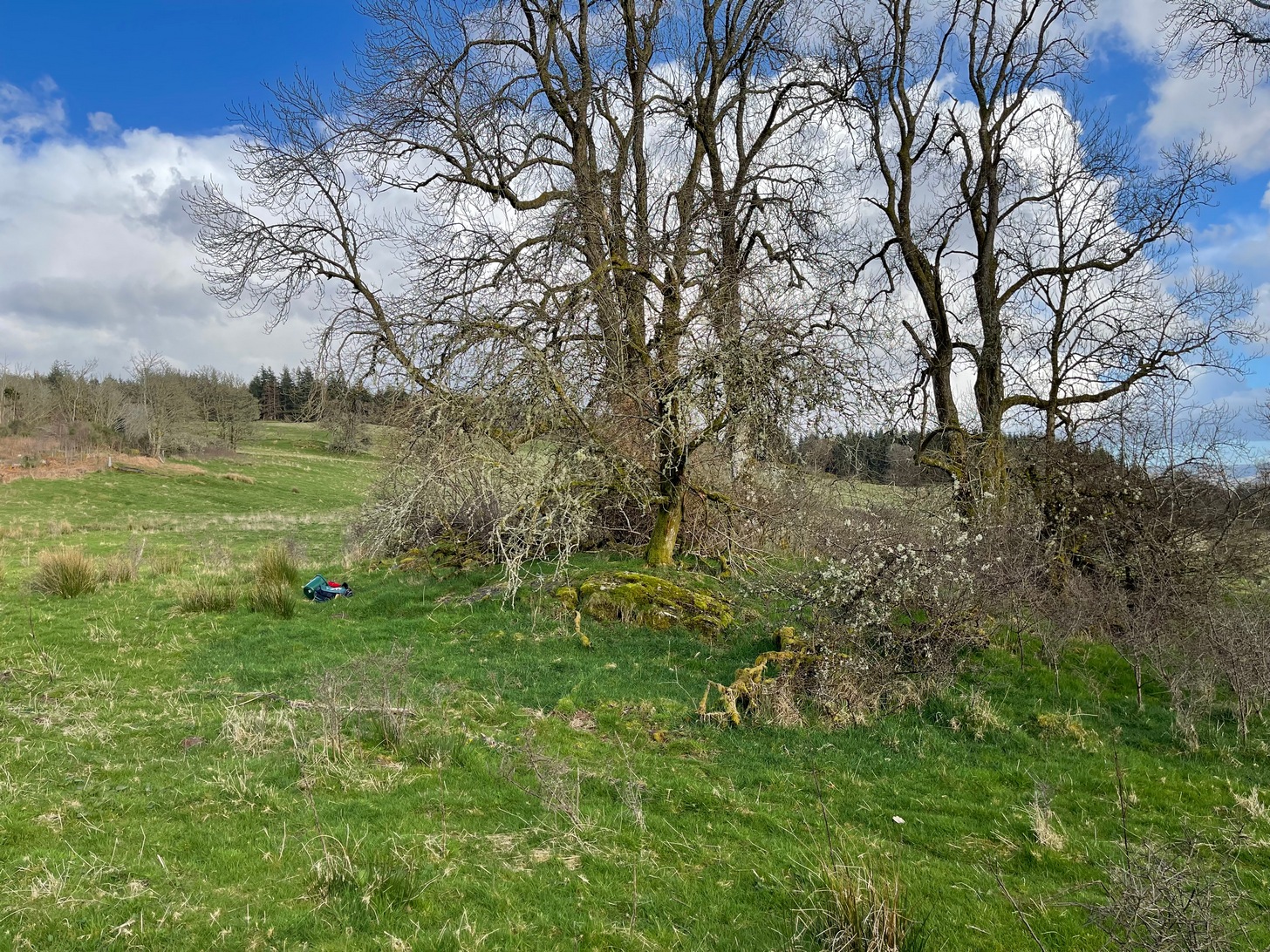
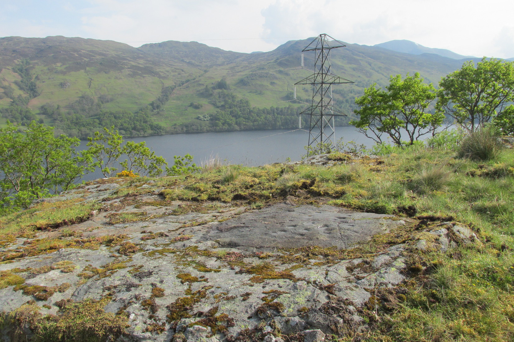
Anyone who’s going to visit this carving will be doing so as a result of visiting the impressive Blarnaboard (3) cup-and-ring stone, 115 yards (105m) away.  From Blarnaboard (3), walk down the slope on your right (west), cross the tiny burn and go round to the other side of the small rocky hawthorn-topped hillock just a few yards in front of you.  Fumble about and you’ll find what you’re looking for!

Archaeology & History

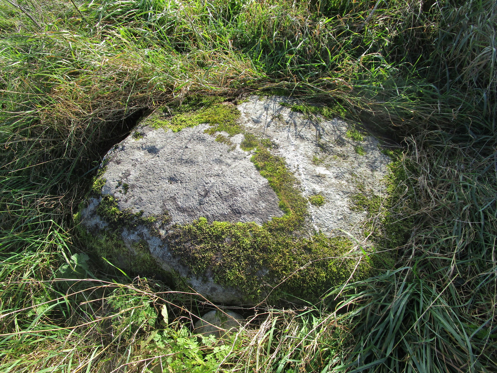
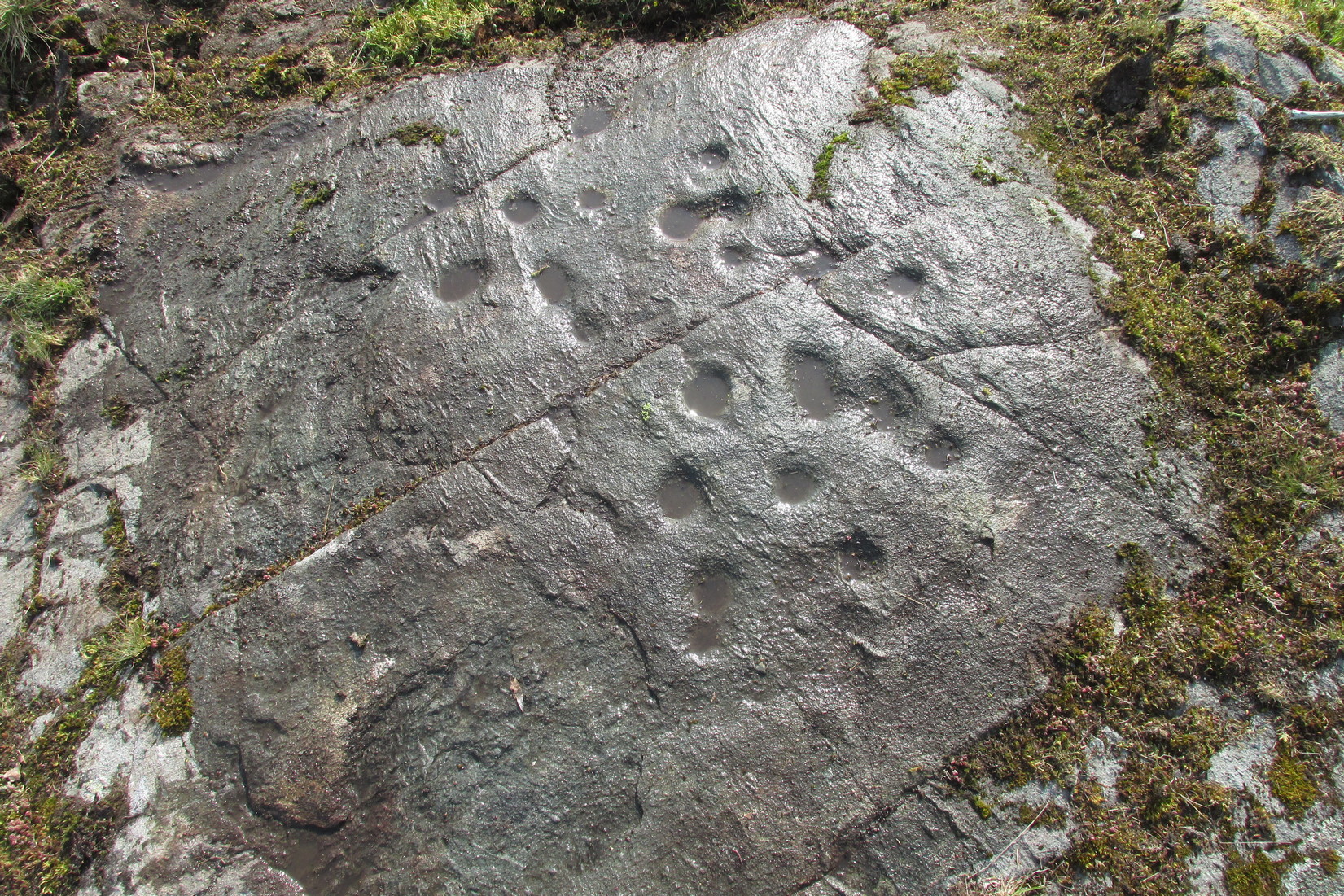
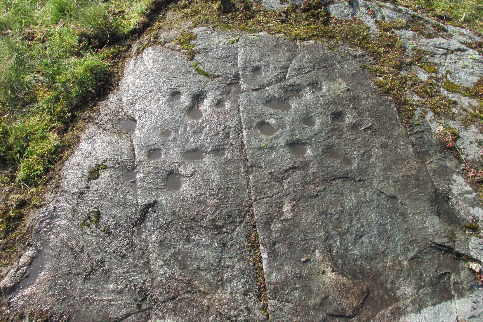
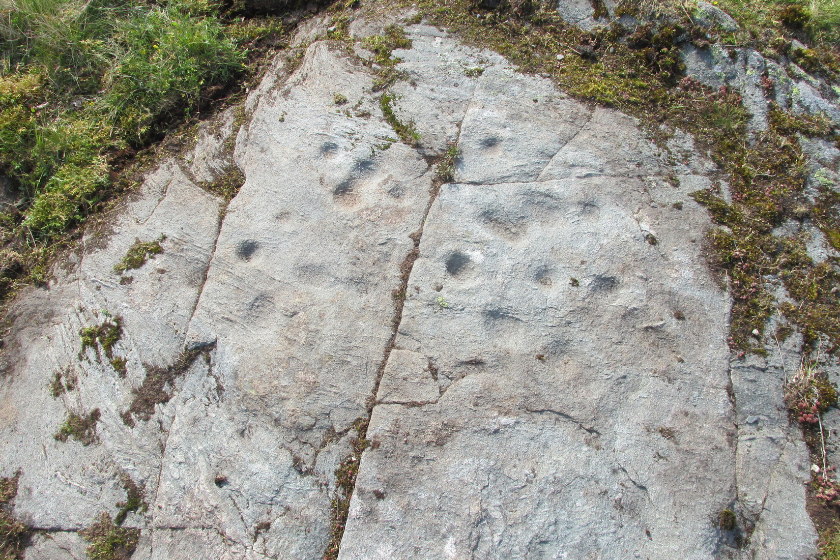
It’s possible that there’s more to this carving than meets the eye.  On the west-side of this small rocky rise, along a thin elongated raised section in the stone, a gently meandering line of nine deep cups runs roughly northeast to southwest.  You can’t really miss them as they average some 2 inches across and 1 inch deep, strongly suggesting that they were cut and reworked over and over for a long period of time.

Line of cups, from above
Rough NE-SW alignment

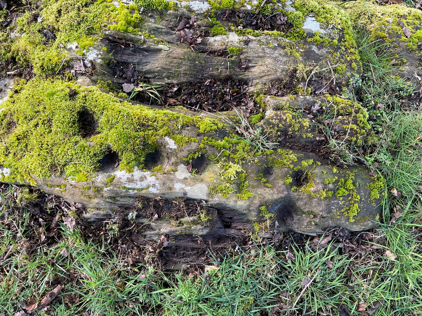
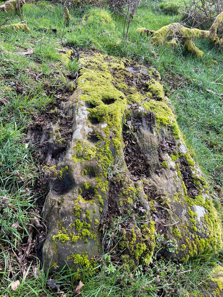
It was first described in distinct brevity by Lorna Main (1988) who told that, “over a length of 60cm on a north-east facing outcrop are 9 cup marks.”  And, whilst all of the cups are clearly visible, one of them at the edge of the stone has been cut or worked into a natural curved hollow.  You’ll see what I mean when you visit the site (it’s pretty clear in the photos).

Beneath the roots and soil there may well be other cup-markings that are still hiding away on this rocky dome.  I have no doubt that other unrecorded carvings exist in this area, but due to the excessive forestry plantations all around here, they will be covered over or have been destroyed.

References:

  1. Main, L., “Blarnaboard (Drymen parish), Cup Marked Rock,” in Discovery & Excavation Scotland, 1988.

© Paul BennettThe Northern Antiquarian

West Cowden Farm, Comrie, Perthshire

Cup-Marked Stone:  OS Grid Reference – NN 77451 20648

Getting Here

Cowden Farm cup-marks

From Comrie take the B827 road (towards Braco) out of town and where the fields open up on both sides of you, 400 yards along the straight road you’ll see a large bulky stone right by the roadside (it’s the standing stone known as the Roman Stone). Stop here and look on the ground just a couple of yards past the monolith where, amidst the grasses and mosses, you’ll see this small smooth stone (you might have to roll some of the mosses back to see it properly).

Archaeology & History

More than a hundred years ago when John MacPherson (1896) wrote his essay on the history of this area, he described there being “three large stones, supposed to be the remains of a Druidical temple.”  He was talking about the Roman Stone here, with its two companions—although only the Roman Stone remains upright today. He noted that one of them, on the ground was “a round, flat boulder” which “bears upon its surface cup-marks arranged in irregular concentric circles.”

This seems to have been the first mention of the carving.  Fifteen years later when the great Fred Coles (1911) looked at the same standing stones, he found the adjacent petroglyph to still be in situ, stating that,

“The surface is covered with a group of twenty-two neatly made cups … the majority being about 2 inches in diameter, with a few much smaller. Two cups measure only 1 inch in diameter.”

R.M. Pullar’s 1914 photo
Fred Coles’ 1911 sketch

A few years after this, members of the Perthshire Natural History Society on an excursion to Glen Artney in May 1914, stopped here to have a look at the same standing stones and they also pointed out that one of the stones “lying on the ground…is remarkable for the numerous cup-marks on its surface.”  In truth, it’s not that remarkable compared to some of the other carvings, but it’s still worth checking out when visiting the other sites in the area. Many of the cups that were visible a hundred years back are difficult to make out unless the light is good; and it seems as if some of them have been chipped away, perhaps due to farming activity.

References:

  1. Barclay, W., “Winter Session, 1914-1915,” in Transactions & Proceedings Perthshire Society Natural Science, volume 6, 1919.
  2. Coles, Fred, “Report on Stone Circles in Perthshire, Principally Strathearn,” in Proceedings Society Antiquaries, Scotland, volume 45, 1911.
  3. Hunter, John, Chronicles of Strathearn, David Philips: Crieff 1896.
  4. Mac Pherson, John, “At the Head of Strathearn,” in Hunter’s Chronicles of Strathearn (David Philips: Crieff 1896).

© Paul BennettThe Northern Antiquarian

West Lamberkine (2), Aberdalgie, Perth, Perthshire

Cup-and-Ring Stone (lost):  OS Grid Reference – NO 0654 2296

Archaeology & History

All trace of this carving seems to have gone.  It was first recorded by the great Fred Coles (1903) who found it within a small group of stones, but no one has seen it since.  Unless it’s been shifted into one of the nearby walls, it may have been destroyed.  Coles told us it could be found,

Cole’s 1903 sketch of the carving
Stone ‘A’ is the culprit

“at a point 333 yards east of the farm-steadings, where two hedges meet at right angles.  Four stones…lie close together.  They appear to be all of bastard whinstone.  The middle stone, B, has its longer axis ESE and WNW.  It is only 3in inches thick.  The stones D and C are each 6 inches thick.  No marks are to be seen on any of these.  But on A is the very distinct sculpturing shown in the illustration…unfortunately not complete, owing to the flaking off of large strips of the weathered lower portion of the slab.  There is a strong suggestion of a cist-cover in the shape and size of this stone, which the close proximity of the two other squarer and thinner stones helps to enforce. Though these  stones have been known to the tenant for over thirty years, this is, I believe, the first record made of their position and features.”

The records at Canmore have suggested that this lost carving and the missing petroglyph of West Lamberkine (1) nearby are one and the same.  This is unlikely.  West Lamberkine (1) was described simply as a cup-marked stone, whereas this stone possessed clear identifiable cups and rings.  It would be difficult to make such an elementary mistake.

References:

  1. Coles, Fred,  “Notices of…Some Hitherto Undescribed Cup-and-ring-marked Stones…” in Proceedings Society Antiquaries Scotland, volume 37, 1903.

© Paul BennettThe Northern Antiquarian

St. Helen’s Well, Gosforth, Cumbria

Holy Well (lost):  OS Grid Reference – NY 0562 0303

Archaeology & History

Described as being “lost” in John Musther’s (2015) relatively recent survey, very little has been written about this site but, by the look of things, it may still exist—albeit in a boggy state of affairs!  It was mentioned in Parker’s (1926) classic history book of the area:

“Near to Newton is a very plentiful spring which is known to have been moved further from the house than it was.  Adam de Newton, son of Richard, mentions in one of his grants, “St. Helen’s Well, which is at the corner of my garden, the outfall going into Grucokesgile beck.”

Possible site of the Well

Parker found it to have been described in a local property charter in St Bee’s Register (Wilson 1915) as far back as 1220 CE.  On the earliest OS-map of the area, a “Spring” is shown just above Newton, which may mark the very spot!  Not far from the holy well was also a cross-marked stone called the Grey Stone (grey stones are usually boundary stones, but can also be standing stones—of which there were a lot in this neck o’ the woods).

Folklore

St. Helen’s Day was celebrated on August 18, but there seem to be no accounts of traditional customs recorded here.

References:

  1. Harte, Jeremy, English Holy Wells – volume 2, Heart of Albion press: Wymeswold 2008.
  2. Musther, John, Springs of Living Waters, privately printed: Keswick 2015.
  3. Page, Jim Taylor, Cumbrian Holy Wells, North West Catholic History Society: Ormskirk 1990.
  4. Parker, C.A. The Gosforth District: Its Antiquities and Places of Interest, Thomas Wilson: Kendal 1926.
  5. Wilson, James, The Register of the Priory of St. Bees, Surtees Society: Durham & London 1915.

© Paul BennettThe Northern Antiquarian

Cat Nab, Brotton, North Yorkshire

Tumulus (destroyed):  OS Grid Reference – NZ 6692 2154

Archaeology & History

Location on 1930 OS-map

This long lost burial mound was first located by the local antiquarian William Hornsby in the early 20th century.  It had been constructed close to the summit of the prominent rise  of Cat Nab, immediately east above Saltburn.  Its position was shown on the 1930 OS-map of the area.  Destroyed by quarrying, it was thankfully excavated by Hornsby in 1913; and although his finds were never published, he left notes which told us that,

“there were two cremations and the sherds of at least three vessels: a collared urn, a pygmy cup and a vessel with an everted rim.” (Crawford 1980)

Crawford (1980) told that these finds could been seen in the Middlesborough Collection.

References:

  1. Crawford, G.M., Bronze Age Burial Mounds in Cleveland, Cleveland County Council 1980.

Acknowledgements:  Huge thanks for use of the Ordnance Survey map in this site profile, reproduced with the kind permission of the National Library of Scotland

© Paul BennettThe Northern Antiquarian


Wester Glentarken (4), St Fillans, Comrie, Perthshire

Cup-and-Ring Stone:  OS Grid Reference – NN 66412 24837

Getting Here

Wester Glentarken (4) in situ

1½ miles out of St Fillans on the A85 road towards Lochearnhead you reach the boating marina by the lochside.  100 yards or so past this, park up.  Cross the road and walk 50 yards to your right then follow the dirt-track up into the trees.  After ⅓-Mile (0.5km) turn left to the old house on your left and follow the green path around it, then around the right-side of the rocky knoll to the Wester Glentarken (1) and (2) carvings. From here walk straight uphill, direct north, past the pylon and onto the rocky outcrop behind the gorse shrubs. You’re here!

Archaeology & History

Away from the edge of this relatively flat rock surface, hemmed in between three geological scars, this decent petroglyph shows its memory to prying eyes.  It was first described by George Currie (2005) as being just “17 cups (and) one pair of cups are linked”, but there are, as usual, more elements to it than that.

Faint cup-&-rings visible

As we can see quite clearly in the photos here, two of the cups possess rings around them.  One of the cup-and-rings near the middle of the mass of cups is complete, with a short line running out of it and into the longest of the natural cracks that frame the design and that runs all the way across the surface of the stone.  This cup-and-ring plays a part in a rough circle of cup-marks surrounding a central cup, with one of the outer cups possessing a companion just outside the ring.  Two cups in this circle are elongated.  There is a possibility that the cup-and-ring I’ve mentioned has another line running from it into the cupmark at the centre of the circle.

On the same side of the long natural crack, outside the circle of cups, is another cup with a faint ring around it.  Tis difficult to say whether or not this was originally complete, but when we zoom in it’s pretty damn close!

Framed secondary cluster
The carving when dry

On the other side of the long natural crack is a haphazard spread of nine more cup-marks, with at least one of them seeming to possess a very faint incomplete ring around it.  You can just make it out in one of the attached photos.  From some angles it seems that two other cups may possess fragments of carved rings around them, but more visits are needed in better light before we can say this with any certainty.  One of the cups in this cluster is elongated, whilst two other cups in this bunch are conjoined.  Another crack to the side of this secondary cluster has one or two more cups cut into it.  Altogether we have between 19 and 21 cups on this petroglyph, with rings around several of them.  Worth checking out when you visit this neck o’ the woods.  And, of course, if you’re a serious rock art researcher, scan the slopes hereby as other carvings yet remain hidden.  You can almost feel them breathing…..

References:

  1. Currie, George, Wester Glentarken, Perth and Kinross (Comrie parish), Cup-marked Rocks,” in Discovery & Excavation Scotland, volume 6, 2005.

© Paul BennettThe Northern Antiquarian

Gala House Museum (2), Galashiels, Selkirkshire

Cup-and-Ring Stone:  OS Grid Reference – NT 49165 35897

Archaeology & History

Gala House (2) carving

One of two petroglyphs housed in the Gala House Museum, whose background is somewhat of a mystery.  When the northern antiquarian Paul Hornby visited the museum, his enquiries regarding its history and place of origin drew a blank.  This small squared block of stone has obviously been broken from a larger piece, but the whereabouts of its adjoining fragments are unknown.  The section that remains that we see here is somewhat more complex than it’s companion petroglyph, comprising as it does (in the photo on the right) a concentric cup-and-two-rings,with another arc above it that has a carved line running vertically into it.  An elongated cup-mark sits to the side of this line.  On the lower-left side we can see where a fragment of the stone has been broken off and here is a cup marking with a double arc above it, that may originally have been another cup-and-two rings.  The curious angular lines at the bottom of the stone look like more recent scratches, perhaps from an industrial machine (tractor?) created when the stone was moved from its place of origin.  If anyone knows anything about this carving, please let us know.

Acknowledgments:  Big thanks to Prof Hornby for use of his photo. 🙂

© Paul BennettThe Northern Antiquarian 

Gala House Museum (1), Galashiels, Selkirkshire

Cup-and-Ring Stone:  OS Grid Reference – NT 4917 3590

Archaeology & History

Gala House Museum stone

A curious stone, inasmuch as nothing seems to be known about it!  When the northern antiquarian Paul Hornby visited the Gala House Museum he was pleasantly surprised to find this multiple-ringed petroglyph on display.  Upon enquiring as to its history and original location, he was informed that it had been donated locally but nothing was known about it.  Incredible!  One of two carvings in the museum (the origin of the other carving is equally mysterious), this portable petroglyph has three rings surrounding the central cup, which has a short line running out of it and to the edge of the third ring.  The petroglyph may have come out of a nearby prehistoric tomb.  If anyone knows anything about this carving, please let us know.

Acknowledgments:  Big thanks to Prof Hornby for use of his photo. 🙂

© Paul BennettThe Northern Antiquarian 

Wellford, Fern , Angus

Standing Stone (destroyed):  OS Grid Reference – NO 483 603 (approximation)

Archaeology & History

In an area once teeming with megaliths, this is but one that lost its life in the 19th century.  It would seem that the only reference of its existence—and demise—comes from the pen of the great regional historian Andrew Jervise (1853) who, in a description of the nearby holy well of St Ninian, in a field near Wellford,

“within the last half century there were two or three large rude boulders nearby, which were called Druidical stones.”

References:

  1. Jervise, Andrew, The History and Traditions of the Land of the Lindsays in Angus and Mearns, Sutherland & Knox: Edinburgh 1853.

© Paul BennettThe Northern Antiquarian

Atis Cross, Flint, Flintshire

Cross (destroyed):  OS Grid Reference – SJ 2534 7208

Archaeology & History

Actual location of the cross

This long-gone site, described in the Domesday Record of 1086 as Atiscros Hund, (or “hundred”, which is the word given to an administrative division of land which, at that time, was on the western edge of Cheshire bordering Wales), gained its title from an old English personal name, Æti.  The fact that it stood on an ancient boundary and was included in Domesday, means it would have been a stone cross.  Its location was shown on the 1871 Ordnance Survey map (and several subsequent ones), based on traditional accounts about its position.  The site is still preserved in local street-names.

Referring to the monument itself, Thomas Pennant (1796) said that it still existed in his day, telling that,

“A cross stood there, the pedestal of which I remember to have seen standing. There is a tradition that, in very old times, there stood a large town at this place; and, it is said, the foundations of buildings have been frequently turned up by the plough.”

References:

  1. Dodgson, J.M., The Place-Names of Cheshire – volume 4, Cambridge University Press 1972.
  2. Pennant, Thomas, The History of the Parishes of Whiteford and Holywell, B. & J. White: London 1796.
  3. Taylor, Henry, Historic Notices, with Topographical and other Gleanings Descriptive of the Borough and County-Town of Flint, Elliot Stock: London 1883.

© Paul BennettThe Northern Antiquarian