Pretty easy to get to. Best thing to do really, is ask a local and they’ll send you in the right direction. From Bingley, take the Harden road (B6429) across the river. As it bends sharply left, note there’s a track going up into the woods to the right. Walk up it! Keep going and, unless you take a detour, you’ll end up at the rock outcrop eventually (where the woods come to an end, Druid’s Altar appears before you with the track running along its top-side).
Archaeology & History
Mentioned in the Tithe Awards of 1849, this lovely outcrop of rocks looking down the Aire Valley on the southern edge of Bingley has “an immemorial tradition” of druidic worship, said Harry Speight in 1898 – though quite when it first acquired such repute is outside of any literary record. In Sidney Greenbank’s (1929) rare book on this place, he could find little by way of archaeological data to affirm the old tradition, save the odd prehistoric find of flints here and there; though it is said that Beltane fires were burned upon the crags here in bygone centuries.
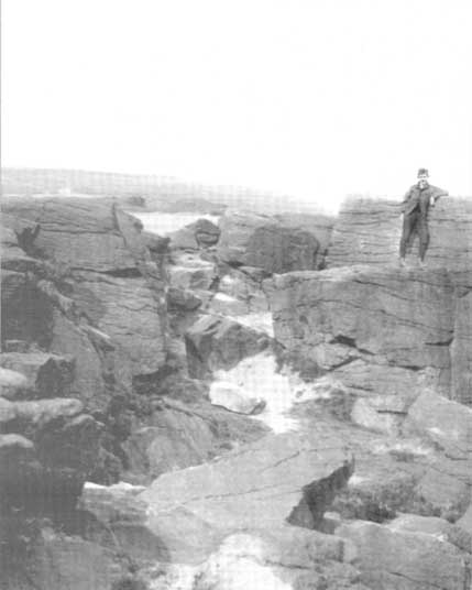
1894 photo of Druid’s Altar (courtesy Clive Hardy)
There was a 19th century account from the Ilkley Scientific Club where a member described there being a cup-and-ring carving “near the so-called Druid’s Altar, at Bingley,” but I’m unaware of the whereabouts of this carving and Boughey & Vickerman’s (2003) said nothing about it in their survey; though a possible cup-marking can be seen on one rock less than 100 yards west, which might account for the report. (a bit dodgy though!)
Folklore
Harry Speight (1898) makes what sounds like a rare flight of fancy when he described faerie being seen atop of the many oaks beneath the Druid’s Altar. In Clive Hardy’s (2002) work (from whence the old photo of the Altar is taken), he tells how “local antiquarians say that the cobbled way running from the Brown Cow Inn towards the site, is an old processional route walked by the druids.”
One, possibly two wells, each beneath the Altar rocks, are also reputed to have been associated with the old pagan priests, as their names tell: the Altar Well and the Druid’s Well – though the Altar Well has seemingly fallen back to Earth in recent years.
References:
Greenbank, Sidney, The Druid’s Altar, Bingley, R.G. Preston: Bingley 1929.
Hardy, Clive, Around Bradford, Frith Book Ltd: Salisbury 2002.
Get to Widdop reservoir in the hills west of Hebden Bridge and park up. The great rock faces to your right (north) is where you’re going. Clamber to the top until the moor levels out, making sure you head NNW for less than a mile. The moors you’re now on are supposed to be private – but folk like me pay no attention! There are no footpaths to this great outcrop, only the heathlands and scattered stones – but keep walking for a half-mile north and you’ll get to them!
Archaeology & History
Erroneously ascribed by the place-name masters Eilert Ekwall and A.H. Smith (1961) as being ‘a place where doves gathered,’ this gigantic rock outcrop on the Yorkshire-Lancashire border — as shown on early maps — is actually the Dew or Black Stones (from the Gaelic, dubh). It’s an awesome place! Takes a bitta getting to, but it’s well worth the venture.
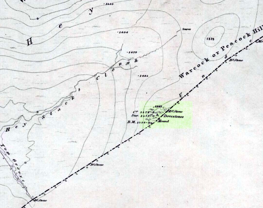
Dove Stones on 1848 map
This long geological ridge, rising higher as you walk along it to the north, has the occasional cup-mark on it, with the giant Dove Stone at the very end having a cup-and-half-ring on its crown (be careful not to fall off). From here, you look across a huge, desolate, U-shaped valley, the far side of which we rise to 1700 feet and the grand setting of the Lad Law.
Folklore
The folklorists Harland and Wilkinson (1882) included this in their survey of druidical sites, mentioning the several cup-markings, or druid basins as they called them. (though most of ’em on here are Nature’s handiwork)
For me, this is an incredible place – full of raw power and magick. It has a curious geomantic relationship with the Whinberry Stones, a couple of miles to the south, around which should be a ring of stones…though none can be found.
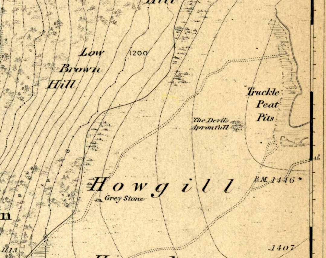
An excellent spot with fantastic views. There’s many ways to approach the place, but a good one is from the roadside by Howgill, then following the track uphill until you reach the moor, then head towards the spectacular and legendary, Simon’s Seat (which folklore ascribes to be named after the great druid, Simon Magus). You’ll pass an old Grey Stone (two large rocks) from which you can espy the old tomb if you stand on top of ’em. Keep walking uphill and it’s about 100 yards off the footpath to your right. A large boulder is nestled just beneath the tomb itself, which stands out on a ridge.
Archaeology & History
When Harry Speight visited here (1900) he described it as being 40 yards in circumference. He also described “an upright stone below the cairn” with apparent cup-markings on the west-side. I’m not quite sure where this has got to – but the site has shrunk somewhat since Speight’s day. It’s only about 20 feet across now, and the middle of it has been hollowed into a grouse-shooting butt for the toffs!
About 100 yards southeast (towards the Truckle Stones) are the remains of some neolithic walling in a straight line.
Folklore
One of many old tombs in our northern hills said to have been created by the devil who, as usual, accidentally dropped some stones he was carrying. The old folklorist Thomas Parkinson (1888) said the following of this place:
“The Apronful of Stones is a group of rocks heaped together in delightful confusion, their disorder and name being thus explained: Once upon a time—whether when he built the bridge over the valley, or at some other time, the record saith not—the Devil was determined to fill up the ravine, or gill, of the Dibble. For this purpose he was carrying these enormous crags in his apron, when, too intent upon his object to properly observe where he placed his feet, he caught with one foot upon the top of Nursa Knott, and, stumbling, the strings of the apron broke, and the contents were thrown upon the ground as they now appear. It is also said of them that if any of them, even now, were to be removed, they would certainly be brought back to their original place during the succeeding night.”
Another legend tells that the Devil’s Apronful is also the grave of some local unnamed hero.
References:
Parkinson, Thomas, Yorkshire Legends and Traditions – volume 1, Elliott Stock: London 1888.
Speight, Harry, Upper Wharfedale, Elliott Stock: London 1900.
Take the A816 south from Oban and after 2 miles at the hamlet of Kilmore, turn left. Follow the road for nearly a mile and as the loch appears ahead of you, stop! The small island crannog is close by the bottom of the loch in front of you.
Archaeology & History
Curiously omitted from the Scottish Royal Commission inventory for Lorn (1974), when R. Angus Smith and his friends explored this artificial island in the 1860s and ’70s, he told:
“it is nearly round, not much larger than a good-sized cottage. It is surrounded by stones large enough to be difficult to lift, and in some places showing themselves to have been put together by art. It would appear as if there had been a pretty firm wall all round – very firm it could not be without mortar or heavier stones. Three or four feet within the range of stones is a raised turf-mound, as if this had been the wall of a house; the centre of the space was rather higher than the rest, and there we expected a fire-place to be found.”
Once they’d got onto the old crannog, Smith and his associates started digging, saying,
“by digging about three feet and a half, the ashes of peat were obtained, bones, charcoal and nuts. A very small hole was made, as we had not then received liberty to dig. We were satisfied that this had been a lake-dwelling, and that it had been defended by a wall. Advantage seems to have been taken of a shallow place, and stones must have been carried to it. It may turn out that there is a wooden foundation. It is not easy to see by what means the covering of earth now over the floor was so much raised. The water of the lake forms little or no deposit in summer; art rather than natural circumstances may have raised the soil. The bones here were split, as at the lake-dwelling in the moss.”
References:
Smith, R. Angus, Loch Etive and the Sons of Uisneach, Alexander Gardner: London 1885.
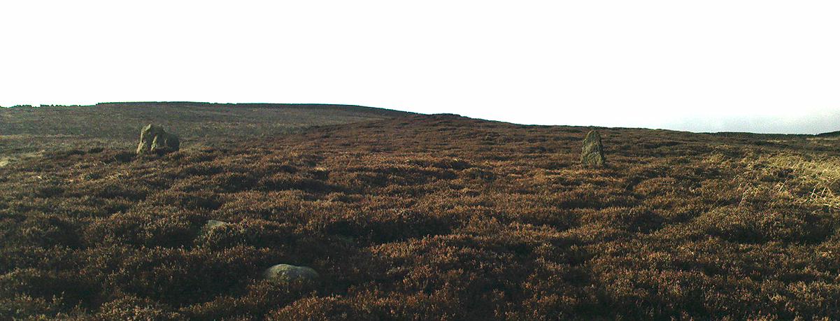
Best approached from Haworth and then walking along the Bronte Way footpath onto the moors (ask at the local Tourist Info if you aint sure). A few hundred yards along, cross the ‘Bronte Bridge’ and keep following the footpath up until you get past the trees and get onto the moors. Once on the heathland, a few hundred yards along keep your eyes to the right and at least one of the two stones here will appear!
Archaeology & History
The original Cuckoo Stone
This is a fascinating little site that has been mentioned in a few old local history guides, including John Lock’s Guide to Haworth (c.1965). First described in 1852 and only briefly noted in passing by Horsfall Turner (1879), the place was previously thought to have comprised just one standing stone, but in recent years explorations by Mark Davey and I found there to be two standing stones close to each other. They are not marked on any maps and are unknown even to many local people. However, the place once had a bit of a reputation (see folklore) and seemed to be well known in the region when the cult of the Church was at its height!
Both of the stones are between three and four feet tall, but the westernmost of the two was probably much taller in bygone days – that’s because the top of the stone was vandalised in centuries past, presumably by some christians if the folktale is anything to go by! On the north-facing side of the western stone is the faint carved outline of an old cross, first described by local historians in the 1960s. It’s faint, but you can work it out if your eyes work properly! The newly-recovered (July 2005) easternmost stone is in two sections, with the very top of it having been hacked off in centuries gone by, as seen in the photos.
The second Cuckoo Stone, resurrected!
When we unearthed the previously unknown Cuckoo Stone (which was laid in the earth and covered with heather and peat), a small deposit of quartz crystals was found in the original socket beneath it when we came to stand the stone back in position. Question is: who put the quartz there? The original builders, or the nutters who knocked it down? And then we might ask: what was the reason behind placing a large handful of quartz beneath the standing stone?
In the heather beyond, about thirty yards to the north, we also find what looks like the remains of an old prehistoric tomb. If we make sense of the Cuckoo Stone’s folklore, we can safely assert that these monoliths were the spirit-home of the old dood/s buried in the tomb behind…
Tis a lovely little place…
There’s also something from that strange electromagnetic-anomaly region attached to this site, well-known to students exploring the physics of megalithic sites. When my lovely friend Mark – “grope me baby! grope me!” – Davey and I rediscovered the second Cuckoo Stone, Mark brought with him a device that measures fluctuations in electromagnetic radiation. The readings taken were fine just about everywhere (background, with minor fluctuations), apart from two very curious straight lines which ran either side of the burial mound down towards the two Cuckoo Stones, with radiation readings being between 10 and more than 60 times above background! The highest readings came from those closest to the burial mound, with levels dropping as we approached the standing stones. Such magnetic anomalies have been found at a number of megalithic sites in the UK, as described in Paul Devereux’s Place of Power (1989) and other books. But the fact that the anomaly lines here seemed to run in lines would be something that those ley enthusiasts would no doubt be intrigued by!
Folklore
The creation myth of this site tells that once, long ago, a great giant lived upon these old moors. He wasn’t a good giant though, from all acounts: robbing and persecuting those who would venture onto the hills hereabouts. The local people wouldn’t dare venture onto the moors and they long sought for a hero who’d be able to sort him out! This eventually happened and in a great fight, our unnamed hero caught and killed the old giant. But just as the giant was about to die, he used his ancient magick powers and, “with a magical groan, he did transform before them and became the Cuckoo Stone.”
But that wasn’t the end of the matter because, as our unnamed hero realised, knowing that the head was the seat of the soul, even in his petrified stoney state the giant may one day recover his life, and so he chopped off the top of the Cuckoo Stone and rolled it into the valley below, dismembering the ‘head’ from the giant, seemingly forever…
It is said that the winnings of this old giant, stolen from his countless victims, are hidden somewhere high upon these hills, awaiting the shovel of some fortunate treasure hunter!
The motif of this tale is universal and archaic, echoing traditional or aboriginal lore from elsewhere in the world. The tale is a simple one: originally the ‘giant’ was a local hero, chief or medicine man who lived on these hills and the Cuckoo Stones his petrified body, and with the incoming christian cult, the giant became demonised. It seems that the ingredient of the giant’s death may infer a burial of sorts and, a hundred yards behind the Cuckoo Stones (both of whom have had their ‘heads’ hacked off), is a mound of earth which, when seen after all the heather’s been burnt away, has all the hallmarks of a prehistoric tomb (it is seen in the top photo above, as the mound in the background behind the standing stones).
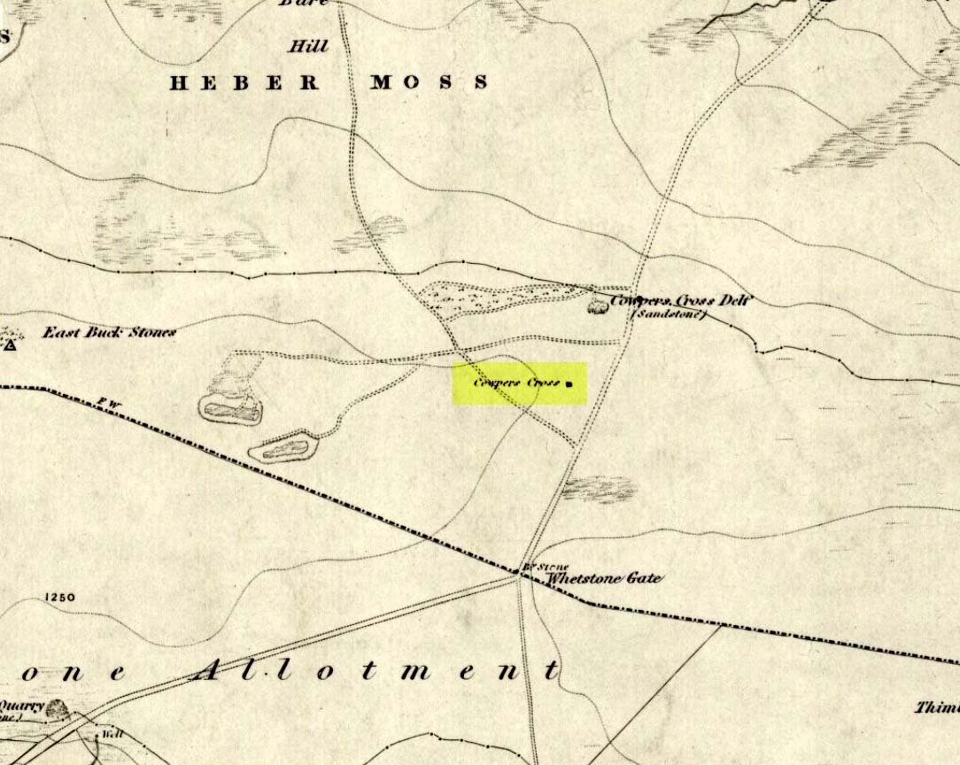
From Ilkley town, head up the road as if you’re going to White Wells but keep following the moorland road up towards Whetstone Gate and the TV masts on the very tops (you’ll have to walk the last half-mile). Shortly before you get them, you can’t miss this relic by the track-side on your right-hand side.
Archaeology & History
Possibly a christianised monolith, erected here in an attempt to divert local people away from the impressive Badger Stone where they may have held springtime gatherings. There used to be an old monolith laid on the ground a few yards away from the cross, which may have stood upright before the cross was erected. Also on the south-facing side of the cross were four cup-markings, indicating great age. These may also have been added when the cross was erected. (We know this occurred at other sites in the region, e.g., Churn Milk Joan, Midgley Moor, where such cup-marks were added sometime in the 15th or 16th century.) However, thanks to some idiotic halfwits in more recent years going up here and vandalizing Cowper’s Cross, the prehistoric cup-markings that were on this relic have been destroyed. The upright shaft of the cross that’s here now is a re-worked gatepost that replaced the old shaft with its authentic ‘pagan’ carvings.
1920s postcard of the Cross
But it’s had other bits of bad luck through the years. The site was struck by lightning many years back, splitting the stone in half, but has since been rebuilt and stands adjacent to its original position, right next to the old Roman road that crosses Ilkley Moor. Historian Allan Butterfield suggested this site to have originally been an old boundary markstone, christianised many centuries ago. The name ‘Cowper’ derives from the local Ilkley family of Cawper.
Those of you interested in the early christian history of these moors should also have a look at the little-known Black Knoll Cross, less than a mile south of here in the middle of Morton Moor.
Folklore
Folklore relates that markets were held at this old stone cross many years ago. This gives added weight to the idea that the nearby cup-and-ring marked Badger Stone, where markets were probably held around the time of the equinoxes, was the original site for such gatherings. Note that another site, the Reva Hill Cross, on the eastern side of this moor, has much the same history.
References:
Bennett, Paul, The Old Stones of Elmet, Capall Bann: Chieveley 2001.
Cowling, E.T., Rombald’s Way, William Walker: Otley 1946.
Stone Circle (destroyed): OS grid-reference – SD 821 613
Also known as:
Druid’s Hill Circle
Druid’s Circle
Archaeology & History
Speight’s 1895 map – showing position of circle
Not included in any previous archaeological surveys of megalithic rings, this circle of stones was apparently visible from quite a distance away, sitting on the hillside where now there is woodland. It was described by the great Yorkshire historian Harry Speight (1892, 1895), though today it seems that all remains of it have vanished.
An early description of it came after an excursion to the site by local antiquarians, who told that “at Cleatop, about a mile to the south of Settle, are the remains of an ancient stone circle.” (Horsfall-Turner 1888) A few years later, Mr Speight gave us more details of the place, saying:
“A little above Cleatop Farm (near Rathmell)…is Cleatop Wood. Cleatop derives its name from the A.S. cleof, a rocky aclivity; Latin clivus, a bank or slope. Near the northeast side of the wood there was once a very noticeable Druid’s Circle, about 60 feet in diameter; indeed, Mr Thomas Brayshaw of Settle, informs me that within the memory of persons still living, it was so regular and well-defined that one or two gaps caused by the removal of stones could be easily distinguished. The eminence at the rear of the site has, from time immemorial, been known as Druid’s Hill.”
Some years later, that very same local historian Tom Brayshaw (1932) wrote:
“The Ordnance map marks, on the steep slope to the north of Cleatop Wood, ‘site of Stone Circle’. It needs a very keen eye to identify the few stumps that remain today, and it is deplorable that this most interesting monument, after enduring for so many centuries, has been destroyed during the last eighty years. In 1847 a description of the circle, as it then was, was sent to Captain Yolland of the Ordnance Survey.
“”I suppose the circle of stones in Cleatop High Park to be aboriginal British or Druidical remains from the following appearances: the circle is complete and the large stones are set on end, some of them several tons weight. The stones are twelve in number now standing, beside several others that seem to be rolled a short distance, as it is placed on the ascent of a steep hill and commands a beautiful and extensive prospect (more so than any given point of the same altitude in the vicinity). The circle is 36 feet in diameter.”
“A few stones were still standing in 1883. The hill above long bore the name Druids Hill. The Enclosure Acts passed towards the end of the 18th century greatly increased the number of drystone walls in the parish, and it is probable that many old stone monuments were destroyed in making them and in their subsequent repair”.
We have no references of burials or other excavations here to give us any idea of whether human remains had ever been found. It’s an intriguing place in the landscape though…and worthy of further explorations…
References:
Brayshaw, Thomas, A History of the Ancient Parish of Giggleswick, Halton & Co.: London 1932.
Horsfall-Turner, J. (ed.), ‘Antiquarian Excursion to Giggleswick and Settle,’ in Yorkshire Folklore Journal, vol.1, T. Harrison: Bingley 1888.
Speight, Harry, The Craven and Northwest Yorkshire Highlands, Elliott Stock: London 1892.
Speight, Harry, Tramps and Drives in the Craven Highlands, Elliot Stock: London 1895.
Also known as the ‘Stones of Islay,’ these two old stones can be found on the west side of the road between Port Ellen and Ardtalla, up the steepish wood-covered slope, just south of the conical fairy hill of Cnoc Rhaonastil.
Archaeology & History
In recent years, the Scottish Royal Commission commented that “they do not appear to be of prehistoric date,” yet include it in the Argyll survey (vol.5:65), just in case! The larger of the two monoliths is nearly 6 feet long (it was on the floor when I came here, many years back), and its smaller companion about 3 feet long (also on the deck!).
Folklore
In 1794, in the Statistical Account of Scotland, it was said that these two curious standing stones marked the grave of Yla or Yula, “a daughter of one of the kings of Denmark,” which is most unlikely. Between these two stones, folklore tells, is known as the Tomb of Yla – a Danish princess whom legend tells gave Islay its name.
The hill above these old stones was long known to be the place of the faerie-folk. Indeed, the Queen of Faerie herself lived here. Otta Swire told a fascinating old folktale of this place, whose nature will be know to some:
“The Queen was much troubled by the stupidity of human women, for in the fairy world wisdom is chiefly possessed by the women, since it is they who hold the Cup. After much thought, She decided to try to improve matters, so she sent out an invitation to all the women of the world to visit Her in Her hall in the knoll on a certain date. The invitation spread over the wide Earth – it was carried by the winds and the sea waves, by birds and by fish, even the leaves of the trees whispered it. And the women of the world were very much interested and they talked eagerly together. Some laughed at it, some said they were wiser by far than the Little People, some held that the Little People were cleverer and more powerful than they and that this might be a trap. Indeed, the word of women ‘heaved like hive of bee or hill of ant or byke of wasp.’ Soon, women from all over the isles began to arrive in Islay. Some came to see, many more to be seen, and a few came truly seeking wisdom.
“When the day dawned the hill opened, and into the wonderful hall within streamed the women. And a very wonderful hall it was, hung with bright cloths woven from nettles and fairy lint and dyed with blood of shell-fish and sap of plants in such colours as only the Little People can achieve. Skins of beasts were spread on floors and seats, a banquet set on shells of pearl lay ready on the many tables of wood and stone, and for each guest there was placed ready a beautiful cup formed from a blue-eyed limpet’s shell. A soft green light pervaded the hall. When all were ready and the watchers saw no more coracles on the waters or maidens climbing the green slope, the doors to the outer world were closed and in walked the Queen Herself. She was smaller than any of Her guests but far, far more impressive. She wore a dress of long ago but it suited well Her gentle, kindly dignity and Her face shone with a strange and lovely light. She carried in Her two hands a wonderful flagon and after her came her maids, each holding a similar one. Other maids hastily distributed the cups of shell and then the Queen walked slowly by, pouring into the cup of each of those who, in her heart truly desired wisdom, a few drops of the precious fluid from Her flagon, which held the distilled wisdom of the world throughout the ages. And as each woman drank those few drops she suddenly grew wise and saw and understood much she had never known before. Some were able to see much, others but a little, yet all benefited in their degree. At last, all who sought wisdom had received it and the elixir was finished. Just as the ceremony ended there came a hammering on the walls and the doors. The Little People looked out and, behold!, their hill was covered with late-comers who had arrived after the doors were closed and so had been unable to enter and were now too late to receive the gift. There is still a saying in Gaelic about a stupid woman: ‘She was out on the knoll when wisdom was distributed.'”
A saying I remember my old grandad telling a few folk a few times when I was young!
References:
Royal Commission on the Ancient & Historical Monuments of Scotland, Argyll – volume 5: Islay, Jura, Colonsay and Oronsay, HMSO: Edinburgh 1984.
Swire, O.F., The Inner Hebrides and their Legends, Collins: London & Glasgow 1964.
Pretty easy to get to. It’s in one of the fields above the old farmhouse of Boreland on the western edge of Fearnan, a couple of hundred yards away on the other side of the road from the Clach an Tuirc.
Archaeology & History
Clach-na-Cruich in 1884
In the field we find this great chair-shaped boulder with a great ‘bowl’ on it where the seating section is, and on its top and sides are a few cup-markings — MacMillan (1884) noted seven of them, two of which had half-rings around them, “associated together in a singular manner, and forming a figure like the eyes of a pair of spectacles.”
Folklore
Regarded in local legends to be an ancient initiation seat, this was taken over and ordained as being the seat of St. Ciaran at some time when the Celtic church started having influence up here.
The ‘seat’ of this great stone regularly fills up with rainwater and was, wrote William A. Gillies, “regarded as an effectual cure for measles, and there are persons still residing at Fearnan who were taken as children to drink from the water in the hollow of Clach-na-Gruich, the Measles Stone.” His lengthy account of the site told:
“In the district of Breadalbane, Perthshire – which has in it the Pool of St Fillans, famous for its supposed power of curing mentally afflicted persons – there are two boulders with water-filled cavities, which have a local reputation for their healing virtues. One is at Fernan, situated on the north side of Loch Tay, about three miles from Kenmore. It is a large rough stone with an irregular outline, somewhat like a rude chair, in the middle of a field immediately below the farmhouse of Mr Campbell, Borland. The rest of the field is ploughed; but the spot on which it stands is carefully preserved as an oasis amid the furrows. The material of which it is composed is a coarse clay slate; and the stone has evidently been a boulder transported to the spot from a considerable distance.
“In the centre on one side there is a deep square cavity capable of holding about two quarts of water. I found it nearly full, although the weather had been unusually dry for several weeks previously. There were some clods of earth around it, and a few small stones and a quantity of rubbish in the cavity itself, which defiled the water. This I carefully scooped out, and found the cavity showing unmistakeable evidence of being artificial. On the upper surface of the stone I also discovered seven faint cup-marks, very much weather-worn; two of them associated together in a singular manner, and forming a figure like the eyes of a pair of spectacles.
“The boulder goes in the locality by the name of Clach-na-Cruich, or the Stone of the Measles; and the rain-water contained in its cavity, when drunk by the patient, was supposed to be a sovereign remedy for that disease. At one time it had a wide reputation, and persons afflicted with the disease came from all parts of the district to drink its water. Indeed, there are many persons still alive who were taken in their youth, when suffering from this infantile disease, to the stone at Fernan; and I have met a man not much past forty, who remembers distinctly having drunk the water in the cavity when suffering from measles.
“It is is only within the lifetime of the present generation that the Clach-na-Cruich has fallen into disuse. I am not sure, indeed, whether any one has resorted to it within the last thirty years. Its neglected state would seem to indicate that all faith in it had for many years been abandoned.”
References:
Gillies, William A., In Famed Breadalbane, Munro Press: Perth 1938.
MacMillan, Hugh, ‘Notice of Two Boulders having Rain-Filled Cavities on the Shores of Loch Tay, Formerly Associated with the Cure of Disease,’ in PSAS 18, 1884.
Although the lads at the Scottish Royal Commission (1974) initially described this site as a ‘Standing Stone’, it is in fact,
“an erratic boulder of granite roughly shaped in the form of a cross… It measures 0.8m in height, 0.6m in width at base, and 0.4m in width at the top…(and) the stone is supposed to have marked a boundary.”
The site was evidently of some mythic importance, as the great Cathedral of St. Moluag was built next to the stone — unless the giant cairn of Cnoc Aingil, 500 yards away, was to blame. A holy well of this saint’s name (an obvious heathen site beforehand) is also nearby.
Folklore
Although this stone was dedicated to swans, I’ve not found the story behind the name. There were no buried swans here, but local tradition told that this old boulder could give sanctuary to anyone who touched it, or ran round it sunwise. The Hebridean folklorist Otta Swire (1964) told that,
“anyone who claimed such sanctuary had his case considered by ‘the Elders.’ If they considered his plea justified, they ‘came out and walked sun-wise round the Swan Stone.’ If they did not approve of his right to sanctuary, they walked round it anti-clockwise and the man was then given over, not to his enemies, but ‘to Authority’ to be tried.”
This old tradition derives from well known pre-christian rites. Swire also reported that even in the 1960s here, “at funerals the coffin is always carried round the grave sun-wise before being laid in it.” An old cross placed in the Field of the Cross next to the stone was an attempt to tease folk away from heathen rites of the stone, but failed.
References:
Royal Commission on the Ancient & Historical Monuments of Scotland, Argyll – volume 2: Lorn, RCAHMS: Edinburgh 1974.
Swire, O.F., The Inner Hebrides and their Legends, Collins: London 1964.


")
