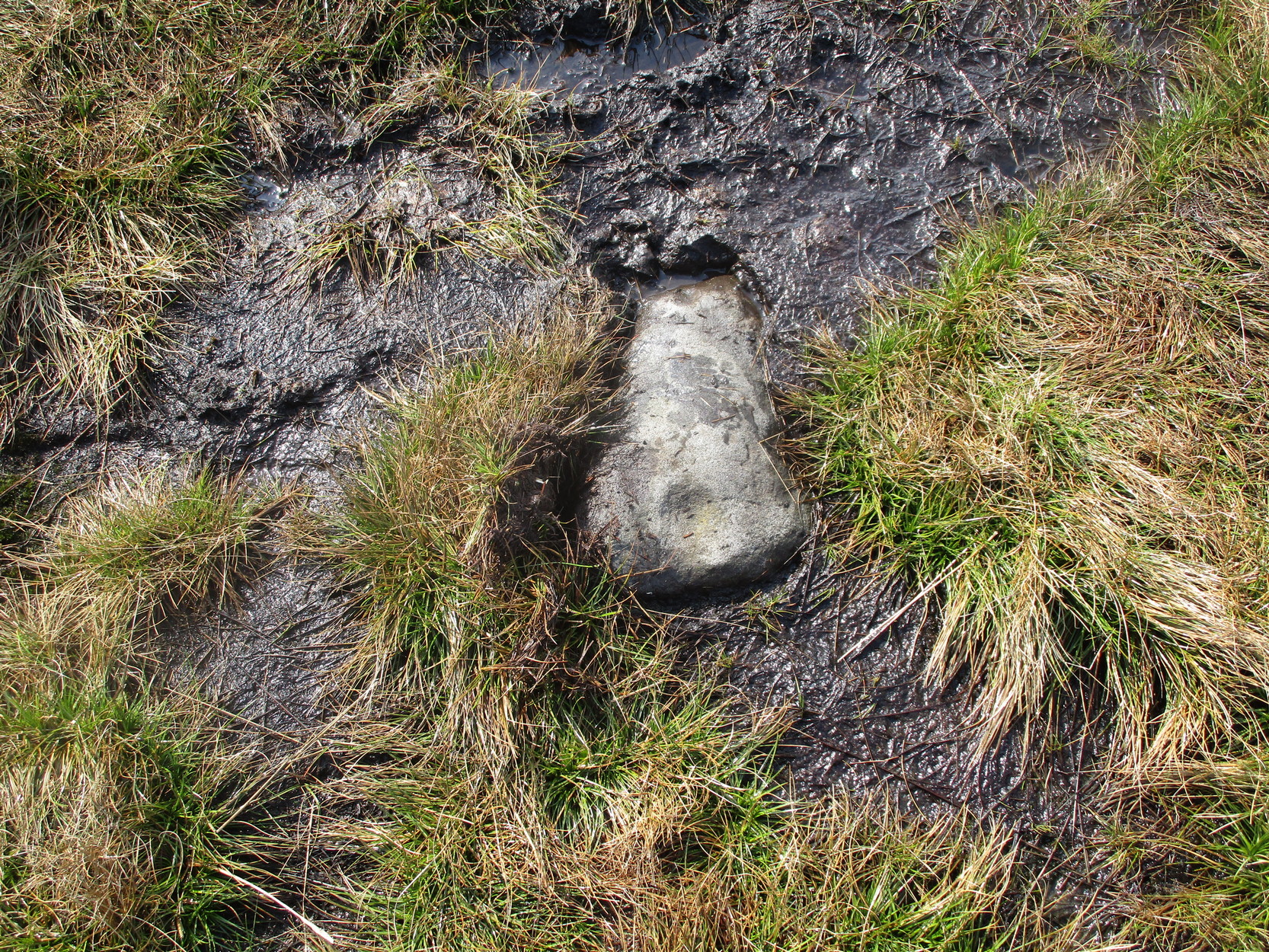
During a walk I did with a small group of people in the Spring of 2024, after a series of heavy rainfalls we ended up having to veer on and off the footpath to ensure we didn’t get swallowed in one of the bogs! In doing so, one of the group, Sarah Walker, noticed a small, almost portable-sized stone sticking up out of the edge of a peat-bog with a very distinct single cup-marking on it. (it may have been on its way as an offering stone to the Little Skirtful cairn) Sarah twizzzled it round a few times in the mud so we could get some good photos of it before we went on our way to the circle at Horncliffe. We didn’t get an exact position for the stone, but it can be found somewhere roughly over halfway between Roms Law and Horncliffe, not far off the path. Good luck!
Acknowledgements: Big thanks to Sarah Walker for stumbling across and uncovering this cup-marking, deep in the moorland mud.
Get yourself to the Roms Law circle, by hook or by crook. Then take the long almost straight footpath south, as if you’re heading to the very damaged Horncliffe Well (thanks to Yorkshire Water). You’ll notice the fencing that runs parallel to the path eventually. Nearly 400 yards along the parallel fenced line you reach the first decent-sized stream. From here, walk upstream, keeping to its northern edges for another 300 yards—then walk 10-20 yards into the heather. You’re damn close!
Archaeology & History
The site is named after Mr James Elkington who recently rediscovered this previously unmapped prehistoric trackway, close to where Burley Moor meets the western edge of Hawksworth Moor, on the greater Rombald’s complex. And it’s a bloody good find if I might say so myself! But, like so many sites covering the Rombald’s complex, it begs more questions than it answers.
2014 aerial view showing outline of trackway2002 aerial view of trackway
The trackway is consistent in architectural design and dimensions with at least six of the eight prehistoric trackways that I’m aware of on these moors — none of which have ever been adequately mapped nor investigated by regional archaeologists (thankfully, there are folk like us around!). This ninth trackway, upon initial investigation, may be the shortest of them all up here.
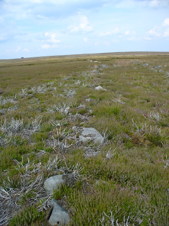
Section of large stones marking the trackOvergrown section of track-edge
Elkington’s Track seems to begin its route about 10-20 yards north of the once large, fast-flowing stream of the Middle Beck—which in itself seems curious. No trace of any trackway seems evident on the other side of this stream and there are no other prehistoric remains accounting for why it should begin or end here…
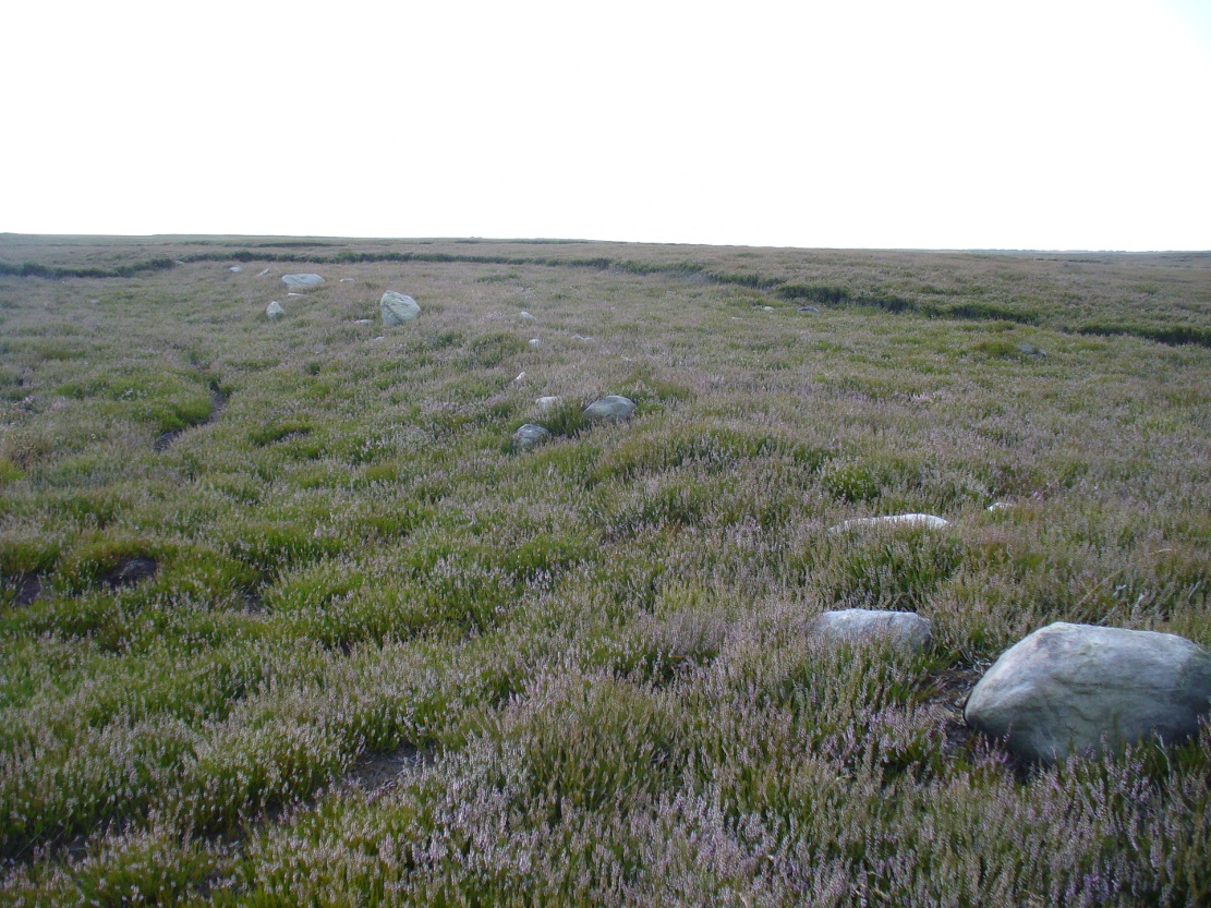
Walking along the track, it heads northeast for 80 yards, with low lines of raised parallel walling 4-5 yards apart defining the avenue, before it begins to gradually bend round in a more easterly direction. Thirty yards along this more easterly alignment, in the southern walled section, lays an eroded stone (SE 13255 44165) that seems to have stood upright in the not-too-distant past. It seems to mark an opening or gap in the walled trackway and a large scatter of small stones, akin to the denuded remains of a cairn is evident just below the track at this point. The raised embankment of the trackway keeps heading east, towards the line of Hawksworth Moor boundary stones.
More long line of walled edgesLooking NE up the track
Upon initial investigation, the trackway was visible for a minimum of 185 yards (169.4m) in length, whereafter any immediate trace of it disappeared into the ancient peat. However, aerial views of it on GoogleEarth indicate a faint extension of the track, but these are difficult to apprehend at ground-level. There is every possibility that this trackway eventually meets up with one of the four other prehistoric trackways near the Great Skirtful of Stones giant tomb, or even the North Road running past Roms Law—but until this can be ascertained, the trackway must be defined on its own merits. Further heather-burning on the moors at either end would obviously enable a great examination of the remains.
In the event that the southernmost point of this trackway does begin above the Middle Beck stream, as seems apparent, we may be looking at a ceremonial trackway and not just a ‘road’ as we define them in the modern parlance of homo-profanus culture. Think of it as a small version of The Avenue trackway that runs from Stonehenge outwards, past the Heel Stone and eventually bending down to the River Avon. (Burl 2006) Y’ just never know…..
References:
Burl, Aubrey, A Brief History of Stonehenge, Constable: London 2006.
Cowling, Eric T., Rombald’s Way, William Walker: Otley 1946.
Raistrick, Arthur, Green Tracks on the Pennines, Dalesman: Clapham 1962.
Wright, Geoffrey N., Roads and Trackways of the Yorkshire Dales, Moorland: 1985.
From Ilkley town, head up the road as if you’re going to White Wells but keep following the moorland road up towards Whetstone Gate and the TV masts on the very tops (you’ll have to walk the last half-mile). Shortly before you get them, you can’t miss this relic by the track-side on your right-hand side.
Archaeology & History
Possibly a christianised monolith, erected here in an attempt to divert local people away from the impressive Badger Stone where they may have held springtime gatherings. There used to be an old monolith laid on the ground a few yards away from the cross, which may have stood upright before the cross was erected. Also on the south-facing side of the cross were four cup-markings, indicating great age. These may also have been added when the cross was erected. (We know this occurred at other sites in the region, e.g., Churn Milk Joan, Midgley Moor, where such cup-marks were added sometime in the 15th or 16th century.) However, thanks to some idiotic halfwits in more recent years going up here and vandalizing Cowper’s Cross, the prehistoric cup-markings that were on this relic have been destroyed. The upright shaft of the cross that’s here now is a re-worked gatepost that replaced the old shaft with its authentic ‘pagan’ carvings.
1920s postcard of the Cross
But it’s had other bits of bad luck through the years. The site was struck by lightning many years back, splitting the stone in half, but has since been rebuilt and stands adjacent to its original position, right next to the old Roman road that crosses Ilkley Moor. Historian Allan Butterfield suggested this site to have originally been an old boundary markstone, christianised many centuries ago. The name ‘Cowper’ derives from the local Ilkley family of Cawper.
Those of you interested in the early christian history of these moors should also have a look at the little-known Black Knoll Cross, less than a mile south of here in the middle of Morton Moor.
Folklore
Folklore relates that markets were held at this old stone cross many years ago. This gives added weight to the idea that the nearby cup-and-ring marked Badger Stone, where markets were probably held around the time of the equinoxes, was the original site for such gatherings. Note that another site, the Reva Hill Cross, on the eastern side of this moor, has much the same history.
References:
Bennett, Paul, The Old Stones of Elmet, Capall Bann: Chieveley 2001.
Cowling, E.T., Rombald’s Way, William Walker: Otley 1946.
 During a walk I did with a small group of people in the Spring of 2024, after a series of heavy rainfalls we ended up having to veer on and off the footpath to ensure we didn’t get swallowed in one of the bogs! In doing so, one of the group, Sarah Walker, noticed a small, almost portable-sized stone sticking up out of the edge of a peat-bog with a very distinct single cup-marking on it. (it may have been on its way as an offering stone to the Little Skirtful cairn) Sarah twizzzled it round a few times in the mud so we could get some good photos of it before we went on our way to the circle at Horncliffe. We didn’t get an exact position for the stone, but it can be found somewhere roughly over halfway between Roms Law and Horncliffe, not far off the path. Good luck!