From Ilkley town centre, taken the road north across the River Wharfe, turning left and up the country lane towards Nesfield. As you’re driving with the farmed fields on either side, you’ll go round a couple of swerves in the lane and reach the open moorland on your right, just past the small copse of trees on the same side. There’s a small place to pullover on the right 100 yards on and walk up the footpath running northeast onto the moor. Go past the disused quarry and up further till you reach the rounded hill where the tumulus stands.
Archaeology & History
On the moors north of Ilkley – as shown on OS-maps since the 1850s – on the southeastern edge of Middleton Moor, is this singular tumulus, a short distance west of some old quarrying at the curiously-named Lurgy Delf. The small hill is easy to find and appears at the western edge of a whole host of neolithic and Bronze Age remains. It is included as a boundary marker between Middleton and Langbar, as marked by an old stone on its southern side. Eric Cowling (1946) described this as “a spread of stones on Round Hill” in the same context as other burial mounds and cairns in the region, also naming it as the Black Hill tumulus. Many flints had been found all round here and it stands at the western edge of a great number of cup-and-ring stones, stretching eastwards across the moors for several miles. To my knowledge, no excavation has taken place here.
References:
Cowling, Eric T., Rombald’s Way, William Walker: Otley 1946.
From Brodick, walk up the Glencloy dirt-track towards the friendly Kilmichael Hotel but turn off on the left shortly before hand, up another footpath, crossing the stream until you eventually reach the derelict house which was built into the edges of this old tomb. Upon the small rise above here, at the edge of the forestry commission trees, you’ll notice the overgrown ruins of the old tomb.
Archaeology & History
The remains here are somewhat overgrown and ramshackled, but I still like this place and in my younger days used to spend a lot of time here. It can get quite eerie in some conditions and seems to validate some of the folklore said of it. The site was described in Balfour’s (1910) magnum opus as:
“Situated in Glen Cloy, on the moor above Kilmichael House, close to a cottage called Glenrickard. There are no traces of a cairn or of a frontal semicircle. The chamber is formed of rather light flags, with their upper edges nearly on the same level, so that the monument is more like a series of cists than a chamber. The roof and end stone have gone; there are two portal stones, but the gap between them is only 7 inches. The chamber is directed N and S, with the portal to the south. There have been three compartments, but they are rather smaller than usual, the third from the portal being only 3 feet 10 inches long by 2 feet 2 inches broad. Two feet 6 inches from this compartment is another cist, which is possibly a short cist representing a secondary interment, and 10 feet farther north is a second ruined cist placed at a different angle. This last has the appearance of a short cist, but it is not carefully constructed and differs little from the component compartments of the chamber. The structure is anomalous, and may perhaps be regarded as representing a phase of degeneration in the transitional period.”
Glenrickard ground-plan (after Henshall 1972)Glenrickard on 1868 map
Audrey Henshall (1972) later descried the site in greater details in her own magnum opus and told that “two rude clay urns of the primitive flower-pot pattern (were) found in the chamber”, along with “calcined bones, said to have been in the two vessels.”
Folklore
Said by local people to be haunted, the spirit of the tomb was said to have been disturbed upon the building of the derelict house below it. Ghosts of a middle-aged couple and young child have been seen in the house; whilst the spirit of the site can generate considerable fear to those who visit the place when it is ‘awake.’ To those who may visit this out-of-the-way tomb, treat the site with the utmost respect (and DON’T come here and hang a loada bloody crystals around the place in a screwy attempt to “clean” the psychic atmosphere of the place. If you’re that sort of person, don’t even go here! The spirit of the place certainly wouldn’t want you there).
References:
Balfour, J.A., The Book of Arran: Archaeology, Arran Society: Glasgow 1910.
Henshall, Audrey Shore, The Chambered Tombs of Scotland – volume 2, Edinburgh University Press 1972.
From the scruffy Askwith Moor lay-by car-park, along Askwith Moor road, follow the fence north up along the roadside until you reach the gate on your right. Go thru this and head due west into the moor, towards the small cluster of other carved stones (carvings 581, 582, etc), particularly the Small Rings Stone (carving 579). Around here, you’ll notice a cluster of about 10 mounds in the heather, which seem to be prehistoric cairns, and this particular stone rest against the northwestern side of one of them, about 30 yards west of carving 579. If you’re patient, you’ll find it! (if you fancy a look at all these on the moor, gimme a shout & I’ll take you straight to ’em – but you need to make a booking!)
Archaeology & History
This carving takes a bitta finding amidst the mass of deep heather and open moorland and is probably only gonna be of interest to real cup-and-ring fanatics. But it’s the setting which makes it more intriguing — for me anyhow!
Trying to highlight the internal CnRSolar Stone carving
Like other carvings on this moorland, we find it in direct association with a prehistoric tomb (though it aint been excavated), resting up against the edge of one. However, it seems to have been moved from its original position and may, perhaps, have actually faced the other way at some time in the past. We might never know. However, some student in the recent past saw fit to name this small carving the ‘TV Stone’, thanks to the slightly cronky outline of an old television screen, with its small half-cup-and-ring near the bottom corner of the rock. You can see where they were coming from!
Boughey & Vickerman (2003) made only a brief note of the stone, seeing only the cup-and-half-ring here; but there seems to be a faint cup-marking near the middle of their TV screen, along with faded evidence of an incomplete ring around it. You can just about make it out in the poor photos we took of it. (sadly, we were without water when we visited it, which would have highlighted the additional cup-and-slight ring more clearly)
Close-up of cup-and-half-ring
We gave this stone the title ‘Solar Stone’* as it seems more appropriate and would certainly have more mythic relevance to the people who carved this. The curious natural ring, or TV outline, running round most of the stone (with the faded cup-and-part-ring near its centre) may have been attached with more animistic attributes than us moderns tend to give things — children notwithstanding! Circular forms in Nature have universal tendencies in more traditional cultures with such heavenly bodies as sun or moon, which might have been relevant here with the stones association with a tomb.
…Again, we might never know…
References:
Boughey, Keith & Vickerman, E.A., Prehistoric Rock Art of the West Riding, WYAS: Wakefield 2003.
* though did debate in somewhat primitive northern lingo: “Ugh – errr…solar? lunar? Ey? — Solar? Lunar?” uttering the same queried mantra numerous times between ourselves till we got tired and stuck with ‘solar’, as seems common these days (though I preferred ‘lunar’, it’s gotta be told!).
From Gilmerton village, take the A822 Dunkeld road north. Go for about 200 yards and take the little road to Monzie; watching carefully another 200 yards on for the dirt-track on the left taking you across the fields. Go along the track, watching out for the small stones in the field on your right less than 200 yards along. You can’t really miss ’em! This small ring of stones is the Monzie Cairn Circle. The carving is just in front of it!
Archaeology & History
Although we know this brilliant carved stone has some relationship with the Monzie cairn circle only five yards away (it was linked via a man-made stone causeway, running between the circle and the carving), the stone itself is very much deserving of its own entry here — and at the same time I can give Andrew Finlayson’s (2010) excellent book a decent plug aswell! (the superb drawings of the stone, top & bottom, are from Andy’s work)
Allen’s 1882 drawingCarving & proximity of circle
First mentioned (I think) in Simpson’s (1867) early survey, the carving was described soon after by J. Romilly Allen (1882), who gave us an early drawing of the stone. Thought by some to have originally stood upright, the carving was described by Aubrey Burl (2000) as being, “decorated with forty-six cupmarks, cup-and-rings, nine double, one triple, there are grooves and a pair of joined cups.” It’s certainly an impressive carving!
Although the carving has been posited by some archaeologists as an outlier to the Monzie circle, it’s probable that the circle emerged from the carving — a concept that some may find difficult to understand. I’m not aware of any modern excavations here (the last, I think, was in 1938), but my guess would be that the stone causeway laid between the cup-and-ring stone and the circle ran towards the circle from the carving, and not the other way round. The carving is probably older than the stone ring — though of course, without excavation, my idea could be utter bullshit! (there are also some cup-marked stones in the circle aswell – though none as impressive as this)
One of my truly favourite megalith fanatics (despite some of his alignments being out), Alexander Thom, came here and thought this old carving “coincided with a rough stellar alignment from the centre-point of the cairn” (Hadingham 1974); though his notes in Megalithic Rings (1980) tell that,
“from the cupmarked stone beside the circle, the midsummer sun sets above an outlier some 800ft distant.”
The “outlier” that Thom mentions is known as the Witches’ Stone of Monzie, which Simpson (1867) appears to have mistakenly thought was the name of this very carving.
References:
Allen, J. Romilly, “Notes on some Undescribed Stones with Cup Markings in Scotland,” in Proceedings of the Society of Antiquaries Scotland, volume 16, 1882.
Burl, Aubrey, The Stone Circles of Britain, Ireland and Brittany, Yale University Press 2000.
Finlayson, Andrew, The Stones of Strathearn, One Tree Island: Comrie 2010.
Hadingham, Evan, Ancient Carvings in Britain, Garnstone: London 1974.
Simpson, James, Archaic Sculpturings of Cups, Circles, etc., Upon Stones and Rocks in Scotland, England and other Countries, Edmonston & Douglas: Edinburgh 1867.
Thom, Alexander, “Megalithic Astronomy: Indications in Standing Stones,” in Vistas in Astronomy, volume 7, 1966.
Thom, A., Thom, A.S. & Burl, H.A.W., Megalithic Rings, BAR: Oxford 1980.
To get here, take the same direction as to reach the Bleara Lowe tumulus, stopping a short distance away when you reach the large heap just by the walling where the moorland levels out. Y’ can’t really miss it!
Archaeology & History
Bleara Moor tumulus
Found on the top of the slope above the Bleara Moor Cairnfield, this is quite a large burial mound that seems to have been forgotten on the small moorland heights above Earby and Lothersdale. No archaeological excavation has been done here and there seem to be no accounts of any finds in local antiquarian records. When we visited the place it was very overgrown and covered in heather, but it stood out in the open landscape. Slightly larger than its more famous companion to the east, this tomb stands three- to four-feet high on average, with a diameter of around 25 yards on its longest northeast/southwest axis. Consistent in structure with the larger cairns on Burley Moor like the Little Skirtful, this tomb was probably built in the Bronze Age. It also seems that a lot of stone has been robbed from this cairn for use in the local walling. The site was given a minimal description on the Pastscape website, where it was described as:
“Round cairn 230m W of Bleara Howe (sic). Scheduled RSM No 23718. A partly mutilated slightly oval mound of peat and heather-covered stones up to 1.2m high with max dimensions of 23m NNE-SSW x 21m WNW-ESE.”
The views from here are considerable and this probably had some relevance when it was first built, but I’m not aware if an assessment of this aspect of the site has been made. More information about the Bleara Moor tumulus (and its companions!) would be hugely appreciated!
Various ways to get here. Probably the easiest is via the golf course itself, walking up towards the top where the trees reach the hills, but keeping your eyes peeled for the large archetypal tumulus or fairy mound near the top of the slope. Alternatively, come up through the wooded slopes from Bridge of Allan and onto the golf course, keeping your eyes ready for the self same mound sat in the corner by the walls. You can’t really miss it to be honest!
Archaeology & History
This is an impressive-looking burial mound sat, intact, on the edge of those painful golf courses that keep growing over our landscape — and you can see for miles from here! It would seem to have been placed with quite deliberate views across the landscape, reaching for countless miles into the Grampian mountains north and west across the moors of Gargunnock and Flanders towards Lomond and beyond…
Fairy Knowe, facing westSir Armstrong’s old drawing
The Fairy Knowe was first excavated in 1868 by Sir J.E. Alexander and his team, when their measurements found it to be some 80 yards in circumference, 78 feet across and 21 feet high — compared to less than 60 feet across and only 8 feet tall today. The findings were recorded in one of the early PSAS reports, and more recently a synopsis of the account was made of it by the Royal Commission (1963) lads who summarized his early findings and told:
“The excavation revealed a cist in the centre of the cairn, laid on the original surface of the ground and measuring 2ft 6in in length, 1ft 6in in breadth and 3ft in depth. Its walls were formed partly of upright slabs and partly of small stones laid horizontally, while the floor and the roof each consisted of a single slab. Within it there was a deposit, 6in in depth, of black earth, charcoal and fragments of human bone among which pieces of a skull were conspicuous. The cist was covered by a heap of large stones, 8ft in diameter and 13ft in height, and this in turn was covered with earth, in which there were charcoal, blackened stones, fragments of human and animal bones and unctuous black earth. Among these remains were found six flint arrowheads, a fragment of what was once thought to be a stone spear-head, and a piece of pine which, it was suggested, might have formed part of a spear-shaft.”
Also, near the top of the cairn in the fairy mound, Sir Alexander’s team located a prehistoric beaker vessel and fragments of what they thought were other beakers pots. Archaeologist Richard Feachem (1977) also mentioned this site in his gazetteer, simply copying the words of previous researchers.
Other prehistoric cairns can be found nearby: one in Cuparlaw Woods less a mile north; plus the Pendreich cairns on the edge of the moors just over 1 mile to the northeast.
Folklore
Obviously an abode of the faerie folk in bygone times, the tales of the place are sadly fading from local memory… Mr Alexander (1868) thought this place may have been an important site for the Pictish folk, and he may well have been correct, as the legendary hill of Dumyat (correctly known as Dun Myat) 2 miles east of here has long been regarded as an outpost of one Pictish tribe.
The main piece of folklore attached to this place relates to its very name and how it came about. In R.M. Menzies (1912) rare work on the folklore of the Ochils, he narrates the local tale that used to be spoken, which describes a procession here from the Fairy Well, just over a mile to the east. Whether this folktale relates to some long lost actual procession between the two sites, we don’t know for sure. Mr Menzies told:
“Once upon a time, when people took life more leisurely, and when the wee folk frequented the glens and hills of Scotland, there was one little fairy whose duty it was to look after certain wells renowned for their curative properties. This fairy was called Blue Jacket, and his favourite haunt was the Fairy Well on the Sheriffmuir Road, where the water was so pure and cool that nobody could pass along without taking a drink of the magic spring. A draught of this water would have such a refreshing effect that the drinker could go on his journey without feeling either thirsty or hungry. Many travellers who had refreshed themselves at the Fairy Well would bless the good little man who kept guard over its purity, and proceed upon their way dreaming of pleasant things all the day long.
“One warm day in June, a Highland drover from the Braes of Rannoch came along with a drove of Highland cattle, which he was taking to Falkirk Tryst, and feeling tired and thirsty he stopped at the Fairy Well, took a good drink of its limpid water, and sat down beside it to rest, while his cattle browsed nearby. The heat was very overpowering, and he fell into a dreamy sleep.
“As he lay enjoying his noonday siesta, Blue Jacket stepped out from among the brackens and approaching the wearied drover, asked him whence he came. The drover said:
“‘I come from the Highland hills beside the Moor of Rannoch; but I have never seen such a wee man as you before. Wha’ may you be?’
“‘Oh,’ said the fairy, ‘I am Blue Jacket, one of the wee folk!’
“‘Ay, ay man, ye have got a blue jacket, right enough; but I’ve never met ony o’ your kind before. Do ye bide here?’
“‘Sometimes; but I am the guardian of the spring from which you have just been drinking.’
“‘Weel, a’ I can say is that it is grand water; there is no’ the likes o’t frae this to Rannoch.’
“‘What’s your name?’ asked the fairy.
“‘They ca’ me Sandy Sinclair, the Piper o’ Rannoch,’ was the reply.
“‘Have you got your pipes?’ asked Blue Jacket.
“‘Aye, my mannie, here they are. Wad ye like a tune? Ye see there’s no’ a piper like me in a’ Perthshire.’
“‘Play away then,’ said Blue Jacket.
“Sandy Sinclair took up his pipes and, blowing up the bag, played a merry Highland reel. When he finished, he was greatly surprised to see above the well a crowd of little folk, like Blue Jacket, dancing to the music he had been playing. As he stopped they clapped their little hands and exclaimed, ‘Well done Sandy! You’re the piper we need.’
“Thereupon Blue Jacket blew a silver whistle, which he took from his belt, and all the wee folk formed themselves into a double row. Blue Jacket then took the Highland piper by the hand, led him to the front of the procession, and told him to play a march. Sandy felt himself unable to resist the command of the fairy, and, putting the chanter into his mouth, blew his hardest and played his best, marching at the head of the long line of little people, who tripped along, keeping time to the strains of the bagpipes. Blue Jacket walked in front of the piper, leading the way in the direction of the Fairy Knowe.
“Sandy Sinclair never marched so proudly as he did that day, and the road, though fairly long, seemed to be no distance at all; the music of the pibroch fired his blood and made him feel as if he was leading his clansmen to battle. When the Fairy Knowe was reached, the wee folk formed themselves into a circle round the little hill, and sang a song the sweetest that ever fell upon the ears of the Highlandman. Blue Jacket once more took his whistle and, blowing three times upon it, held up his hand, and immediately the side of the knoll opened. Bidding the piper to play on, Blue Jacket led the procession into the interior; and when all were inside, the fairies formed themselves into sets, and the piper playing a strathspey, they began dancing with might and main.
“One dance succeeded another, and still Sandy played on, the wee folk tripping it as merrily as ever. All thoughts of Sandy’s drove had gone quite out of his head, and all he thought of now was how best to keep the fairies dancing: he had never seen such nimble dancers, and every motion was so graceful and becoming as made him play his very best to keep the fun going. Sandy Sinclair was in Fairyland, and every other consideration was forgotten.
“Meanwhile his cattle and sheep were following their own sweet will, the only guardian left to take care of them being his collie dog. This faithful animal kept watch as well as he could, and wondered what had become of his master. Towards evening another drover came along with his cattle for the same tryst. He knew the dog at once, and began to pet the animal, saying at the same time, ‘Where’s your master, Oscar? What’s become o’ Sandy?’
“All the dog would do was to wag his bushy tail, and look up with a pleading air, as if to say, ‘I don’t know; will you not find him?’
“‘My puir wee doggie, I wonder what’s come over Sandy? It’s no like him to leave his cattle stravaiging by the roadside. Ay ay man; and at the Fairy Well too! Indeed, this looks unco bad.’
“The newcomer, who was also a Highlander, made up his mind to spend the night with his own drove and that of Sandy Sinclair, thinking that the missing man would turn up in the morning. But when the morning came there was no sign of Sandy.
“Taking Sandy’s collie and leaving his own dog in charge of the combined droves, he said, ‘Find master, Oscar!’ The wise beast sniffed around for a little and then trotted off in the direction taken the day before by Sandy Sinclair and the fairies. By and by they reached the Fairy Knowe; but there was nobody there as far as the drover could see. The dog ran round and round the knoll, barking vigorously all the time, and looking up into the face of the drover as if to say, ‘This is where he is; this is where he is.’ The drover examined every bit of the Fairy Knowe, but there was no trace of Sandy Sinclair. As the drover sat upon the top of the Fairy Knowe, wondering what he should do next, he seemed to hear the sound of distant music. Telling the faithful dog to keep quiet, he listened attentively, and by-and-by made out the sound of the pibroch; but whether it was at a long distance or not, he could not be certain. In the meantime, the dog began to scrape at the side of the mound and whimper in a plaintive manner. Noticing this, the drover put his ear to the ground and listened. There could be no mistake this time: the music of the pibroch came from the centre of the Fairy Knowe.
“‘Bless my soul!’ exclaimed Sandy’s friend. ‘He’s been enticed by the fairies to pipe at their dances. We’ll ne’er see Sandy Sinclair again.’
“It was as true as he said. The Piper of Rannoch never returned to the friends he knew, and the lads and lasses had to get another piper to play their dance music when they wished to spend a happy evening by the shore of the loch. Long, long afterwards, the passers-by often heard the sound of pipe music, muffled and far away, coming from the Fairy Knowe; but the hidden piper was never seen. When long absent friends returned to Rannoch and enquired about Sandy Sinclair, they were told that he had gone to be piper to the wee folk and had never come home again.”
Not to be confused with the Achnacreebeag chambered tomb a short distance to the east, Achnacree is a site that has been made ruinous over the last 100 years, prior to which — as R.A. Smith’s (1885) illustration here shows — we had a quite grand prehistoric chambered cairn to behold. It’s still worth looking at though!
R.A. Smith’s old drawingSmith’s early plan of the cairn
The once giant tomb is neolithic in age and nature, and was defined by Audrey Henshall (1972) as a passage grave of the Clyde Cairns group. It appears to have been built over two different periods: the earliest being when the first two internal chambers were done, “which in building technique and plan are comparable to a two-compartment Clyde-chamber and which may have been covered by a small cairn.” (RCAHMS 1974) Much later, the long passage seems to have been added and built over the original chambers.
Although Smith (1885) and Henshall describe the large cairn, the Scottish Royal Commission (1974) entry gives the most succint archaeocentric summary of the site:
“The cairn is about 24.4m in diameter and now stands to a height of some 3.4m on the S and 4.1m on the NE, although it is said to have been about 4.6m high before excavation; it consists of small and medium-sized stones, interspersed with a few large boulders. A low platform of cairn material, now grass-covered and about 1m high, extends round the base of the cairn and increases the overall diameter to about 40m. The entrance to the passage is on the SE side of the cairn and is marked by four upright stones, one of which is now leaning out of position. The central pair, set about 1.2m apart and protruding 1.3m and 0.4m above the cairn material, are the portal stones on either side of the passage, while the flanking pair may be the remains of a shallow forecourt. The passage, which measured 6.4m in length and 0.6m in width, was constructed of upright slate slabs about 1m in height, and the roof was composed of similar slabs. The excavator recorded that the passage was filled with stones, and these seem to indicate a deliberate blocking after the final burial-deposit. The chamber comprised three compartments. The outer, measuring 1.8m by 1.2m and about 2.1m in height, was constructed of upright slabs and drystone walling supplemented by corbelling, and was covered by a single capstone. The central compartment, measuring 2m by 0.7m and 1.6m in height, was entered across a large transverse slab, and the entrance itself appeared to have been deliberately sealed with stones ‘built firmly in after the chamber had been completed.’ The sides of this chamber were formed of blocks of stone supplemented by dry-stone walling, and it was roofed by a singular capstone. The inner compartment was entered across a sill-stone, and measured 1.4m by 0.9m and 1.7m in height. A combination of slabs and dry-stone walling had been employed in its construction, and it was roofed by a single massive capstone some 0.4m thick. Each side-wall was constructed of two slabs set lengthwise one above the other, in such a way that a narrow ledge was formed at their junction. On these two ledges a number of white quartz pebbles had been deliberately deposited… Three neolithic pottery bowls were discovered in the course of the excavation — a fragmentary vessel from the outer compartment, and one complete and one fragmentary bowl from the inner compartment.”
These bowls were sent to Edinburgh’s National Museum of Antiquities soon after being found.
Folklore
Those of you into earthlights will like this one! Also known as Carn Ban, or the White Cairn, aswell as Ossian’s Cairn, R. Angus Smith (1885:217) told how,
“it was curious…to listen to the superstitions that came out (about this tomb). One woman who lived here, and might therefore be considered an authority, said that she used to see lights upon it in dark nights.”
Another old local was truly terrified of the place, and said he would not enter this tomb for all the money in Lochnell Estate.
Regarding the various names given to the site, when Mr Smith (1885) wrote about it all those years ago, he told:
“We have often inquired the name of the cairn. The cairn really has had no definite name. Some people have called it Carn Ban or White Cairn, but that is evidently confusing it with the other cairn which we saw over the moss, and which is really whiter. Some people have called it Ossian’s Cairn, but that is not an old name, and even if it had been, we know that it is a common thing to attach this name to anything old. We call it Achnacree Cairn, from the name of the farm on which it stands.”
References:
Henshall, A.S., The Chambered Tombs of Scotland – volume 2, Edinburgh University Press 1972.
Royal Commission on the Ancient & Historical Monuments of Scotland, Argyll – Volume 2: Lorn, HMSO: Edinburgh 1974.
Another one of those rare cup-marked stones from Cornwall, once again found in association with a burial— but once again destroyed, this time by having an airfield built over the tomb! This “cup-marked and perforated slab” was said by Paul Ashbee (1958: 192) to have been unearthed “by Mr C.K. Andrew” in 1941 when he was digging in the Nancekuke round barrow. Yet an earlier reference to the same site by Mr o’ Neil (1948: 26) told that “the grave was rifled c.1926, but in the ditch there were found traces of a Bronze Age wooden shovel and a perforated and cup-marked slate.” For any students studying this arena, the correct date would appear to be the earlier of the two.
I’ve not been able to locate any decent photos or diagrams of this small cup-marked stone and would truly appreciate an illustration of it if anyone could get hold of one.
References:
Ashbee, Paul, “The Excavation of Tregulland Burrow, Treneglos Parish, Cornwall,” in Antiquaries Journal, volume 38, 1958.
o’ Neil, B.H. St. John, “War and Archaeology in Britain”, in Antiquaries Journal, volume XXVIII, January-April 1948.
Aerial image showing faint outline of Blackheath circle
From Todmorden, take the road to Hebden Bridge (A646) less than half-mile outta town and just as road goes uphill, watch for the left turn up to Cross Stone. This is one helluva superb steep, winding road if you aint been up it before (which, somehow, I used to be able to cycle up without a break!). As you reach the hamlet of Cross Stone, bear uphill again (left) until you reach the top-end of the golf course, where you’ll see a footpath on your left that runs alongside the course. Walk on this until it reaches a stile. Walk up the wallside and onto the course itself – and there, in front of you, in the middle of the damn golf course, you’ll see the very denuded remains of a once fine prehistoric monument (it’s situation, quite frankly, is a disgrace – and any pagans or historians who feel similarly should complain to Calderdale Council about the lack of preservation here; as the more of us who do, the more they’ll have to pay attention and perhaps do something about it).
Archaeology & History
Very little can be seen of this once important site thanks to the important golf course built right on top of this once sacred site. Thankfully we have an extensive description of the place that was done by J. Lawson Russell (1906) from which this profile account — and every other account for that matter! — draws heavily upon. It was included in Aubrey Burl’s magnum opus (2000) as a stone circle, but this isn’t strictly correct and is more accurately a cairn circle or ring cairn monument.
Blackheath Circle’s shallow semicircular bankBlackheath circle, looking SE
It was thought in times past to have been a monument built by the Romans (hence the earlier title of ‘Roman Barrow’), but its origins were much earlier than those scruffy incomers! Its other local folk name, the “Frying Pan Circle” is, like its namesake at Morley, an etymological curiosity relating to the flat ground left in the wake of its shape: flat, circular, with raised edges surrounding it, not unlike a frying pan.
It was accurately described for the first time by Robert Law (1897), who later broadened his account of the site a year later in a paper he wrote for the Yorkshire Geological Society (1899) after an excavation here. Mr Law and others explored the centre of the ring where they believed it most probable to find remains of some form or another — and they weren’t to be disappointed! The following is taken directly from his lengthy article:
“On Thursday, July 7th of this year (1898), a very interesting and important archaeological discovery was made on a portion of land known as Higher Cross Stone Farm, belonging to Mr. Sutcliffe, of Todmorden. In a field on this farm, called Black Heath, a ring circle, made of earth, has long been known to exist, and has gone by the name of the “Frying Pan.” No history or tradition exists as to the origin of this circle, and various speculations have from time to time been indulged in by the residents. Some have called it a Roman Camp, others a fairy circle, others a circus ring, made to break in horses; but the excavations prove it to be a burial place of prehistoric times. Mr. Tattersall Wilkinson, of Burnley, a well-known archaeologist of considerable experience on ring circles, along with the writer of this article, came to the conclusion, on hearing of this circle, that it probably contained human remains, and an excavating party was organised to meet on the spot on the day above mentioned. This party met at the appointed time, and the plan of operations was to find the centre of the circle, by means of a tape, then to dig a circular trench about three feet from the centre, in which space it was thought the remains would lie. The ring was nearly a perfect circle. It was raised conspicuously above the ground. The rim of raised earth was about three feet wide, and the diameter of the whole circle was thirty yards. After the digging had been going on for a short time, burnt soil and charcoal were met with, and the top of an urn was exposed to view. The diggers then went to work with the greatest possible care, and very soon a beautiful urn was laid bare exactly in the centre of the ring. The urn was embedded in charcoal and calcined bones. It was ten inches high and nine inches at the top, tapering to about three inches wide at the bottom. There was a rim or collar in the upper part of the um about three inches deep, which stood out about one inch in relief from the lower part of it. The collar was ornamented, probably by a pointed stick, with the herring-bone pattern. The outer part of the um was plain. In clearing away the debris from the urn another one was discovered, different in pattern and less in size, but in a very perfect state of preservation.
“About two feet from this, on the opposite side of the central urn, another um was discovered and laid bare, by carefully digging round it with a trowel. This urn was also in a good state of preservation, and about the size of the second one, but differently ornamented. These smaller urns were the same shape as the larger central one, but the ornamentations were not so fine, and they were made of inferior clay. On the south side of the circle, about two feet from the centre, another urn was discovered, but it appeared to be insufficiently baked when manufactured, and had decomposed and crumbled into dust. From the inside of this urn a large quantity of calcined human bones and charcoal was dug up, but the bones were very fragmentary, and the sex of the person to whom the bones belonged could not be determined. Several portions of cranium, rib bones, and lower and upper leg bones were found among the debris.
“Within a few inches of this urn two small (so called) incense cups were found. One of them was very perfect and in an excellent state of preservation and was beautifully ornamented all over. These cups were about three inches in height and three and a half inches in diameter, but tapered a little at the bottom. Indications of three other urns were observed, but they were so much decomposed that little or nothing could be made of them. The others seemed to be arranged about the large central urn and about two feet apart. When the earth had been cleared away from the three perfect urns, and before they had been removed, several photographs were taken of them in situ. One of the smaller urns leaned a little to the south. Several pieces of flint and chert were dug out of the excavation. The urns and incense cups being removed were put into baskets and conveyed to Todmorden, where they were re-photographed and placed in the Free Library for their safe keeping.
“On July 13th, six days after the “find,” the urns were opened at the Co-operative Hall, Todmorden, before a very large gathering of scientific ladies and gentlemen drawn from the surrounding districts. Mr Tattersall Wilkinson, Dr. Crump of Burnley, and the author were entrusted with the opening of the urns.
“The largest one, which was of superior make to the other, was the first to be operated upon. The work was tedious and was done in the most careful way possible. Each operator commenced to pick out by means of a small pocket knife the substances deposited in the urns, and the material was closely examined as it fell out on the table. For the first half-hour or so nothing particular was found. The contents which had been so far dug out were portions of broken urns of a similar pattern to the urn that was being examined, but were not portions of it and must have been placed there as filling-in material. Along with these urn fragments there was some dark brown sand, which appeared to have been burnt, quantities of bituminous soil, small fragments of bones, and bits of charcoal. As the examining party dug deeper into the urn human bones became more numerous and in larger fragments and of a more determinable character, and this went on until the urn had been half emptied. The rest of the contents of the urn then showed signs of being almost entirely calcined bones, and bone after bone was picked out, examined, and laid on the table. Among these bones were fragments of various sizes: of cranium, portions of scapula, pelvic bones, femur, tibia and other bones of the legs. Besides these there were fragments of ribs and perfect toe bones.
“Presently a small cup was laid bare inside the urn, and a few pokes with the knife so far emptied it of its contents that an ancient relic could be seen which differed from any that had yet been found. A moment later a piece of metal was picked out of the cup resembling a spear head. It was about 2½ inches long and 1¼ inches wide at one end, and tapered to a point at the other. It was thin and flat and sharp at the sides and point. It contained a rivet at the two extremities and another one about half way up one side. A bronze pin was also found about the same time as this piece of metal, and on careful examination the metal and the pin were made out to be a bronze brooch, the pin having probably been detached in extracting it from the bones in the cup. Besides this brooch about a dozen beads of a necklace were found, which were chiefly of a rounded shape and about half an inch in diameter. Some of the beads seem to have been made of jet, and some of bone, and were more or less rudely carved. A bone pin was next brought to light. It was almost two inches in length and the eighth of an inch in diameter at one end, tapering towards a point at the other. It was cylindrical in form and slightly curved. The fact of all these ornaments having been carefully placed in the cup and buried with the urn point to the cup having been used as a utensil in which to preserve what was considered of great value. Several human teeth were also found in this cup.
“The opening of the two inferior urns proved that they contained nothing more than the sweepings up of the funeral pile which probably took place after the calcined bones had been placed in the more important urn.
“Since this discovery was made a beautifully-formed flint arrowhead of the leaf-shaped pattern has been found in the same hole from which the urns were dug. There have also been two or three more urns discovered within the same circle, but their contents have not yet been disclosed.”
Early 1899 photo of the Blackheath urnsBlackheath urns on display, c.1911
They had to wait a few more years before a more complete account described the contents of the “two or three more urns” at Blackheath’s circle. That duty fell to Mr J. Lawson Russell (1906), who, after further excavations, wrote the most detailed and complete account of the place.
Following the successful discoveries in 1898, Messrs. Russell, Law, Wilkinson and others made a “further systematic examination of the whole circle”, which was then subsequently wrote up in Ling Roth’s Prehistoric Halifax. The following is a detailed account of that second dig:
“The first step in the systematic examination was the breaking up of the circle into quadrants. This we did by running deep trenches north, east, south and west. The turf was then removed and these quadrants dealt with seriatim. The diameter of the circle was as nearly as possible 100ft (30.5m), i.e. measuring from ridge to ridge, but the slight mound which marked the circumference sloped gently further into the general level of the field. Eight or nine deep furrows ran through the circle, from north to south, cutting the vallum up into segments and ploughing the enclosed area with their parallels. The method we followed was to trench till we came to soil which had never been disturbed. Generally about two spade grafts brought us to stiff glacial (?) clay. When we came upon an urn its position was carefully observed with reference to the centre and noted on a plan ; the earth was removed by trenching round the um, which was photographed in situ when sufficiently defined. The urns were not deeply placed, some of them being only six inches from the surface, none deeper than from 18in to 2ft (46 cm to 61 cm), and all of them without exception were set in the ground upright on their bases, not inverted. There was in the centre an urn, and this was surrounded at a radius of 2ft by a ring of deposits; two having urns, the others either having no urn at all or showing signs only of disintegrated pottery. At a distance of about 10 ft. from the centre another series of deposits was radially arranged, but all to the east side of the north to south centre line. It will be seen that, if we leave out of account the urn found in the vallum in the north-west quadrant, all the urns and deposits save one have been placed to the east of the north to south centre line.
“An extensive floor of charcoal, sometimes an inch to two inches in thickness, was defined to the north of the centre, and two deep pits were located about 16ft (4-9 m) from the centre, one in the north-east and one in the south-east quadrant. Close to that deep spot in the south-east quadrant we found a curiously baked surface which we attempted to photograph. A group of urns, one of which was a fine covered specimen, lay in line going due east from the centre ; and this group had placed all round it flat stones of no great size, set on edge, as if to protect the urns or mark them off from others.
“In the northern half of the circle and lying largely in the NE quadrant, was a considerable area showing a closely beaten, hard baked red floor, with pieces of charcoal speckled amongst the general red. Somewhat similar areas occurred at the west and at the east sides of the circle, that at the west being most marked, the whole floor in that quarter looking like disintegrated pottery closely trodden together.
“Lying NW by W, from the centre, we found in the vallum a large stone with an urn set right in its middle. Other stones lay near, as if they might have been set round this urn in kist fashion. All about this spot the ground seemed to be made up of shivers of sand stone and pounded sand. Over-lying this sand for a considerable area going northwards was a thick layer of charcoal. Curious cairns of stone had been placed just inside the vallum, and these, we soon discovered, accurately marked the cardinal points — N, E, S and W., the most curious of these cairns being that which lay exactly south. The stones here were in the form of a semi-circle, having an armchair -like arrangement in its middle, the back of the chair looking due south, i.e., by the sun at mid-day. In the turf over-lying this strange assemblage of stones a portion of the base of an urn was found, and there was abundance of charcoal at the westerly horn of the semi-circle. Many of the stones in the other cairns lay in groups of three pointing in one direction. Some of the groups looked as if they had been upright at one time and thrown down. At the western point the stones lay in an imbricated fashion, inclined at an angle of about 45°, placed in two rows, about 2½ft (76 cm) apart, five in one row, four in the other. A large flat stone lay near, and by it one which probably was the fifth of the second row. Between these rows of stones, and all around them, lay great quantities of what looked like partly baked clay or disintegrated pottery. In the southwest quadrant lay an incomplete ring of stones, which possibly marked an interment. This incompleteness is interesting and may have had some significance t Other large stones were found set into the vallum at more or less regular intervals. Some of these are still in situ, the further examination of the vallum having had to be abandoned. Close by all these stones charcoal was found, and the upper surface of one, at least, that in the SE quadrant, SE of centre, was blackened as if by fire.
“In removing the stones forming the four cairns I examined all of them for signs of markings, but none was seen except one deeply scored line drawn across the large flat stone in the cairn at the eastern point. This line may have been grooved into the stone by the over-passing plough, but I am rather of opinion that it was purposely graved there. What was the purpose of these cairns and large stones in the vallum? The fact of one large um having been found as already stated, on a stone in the vallum, while part of another urn was found near the southern cairn, suggests a probable explanation for some of these arrangements of stones. They may have been rude kists enclosing urns, or at least they may be regarded as stone-marked interments. The presence of charcoal close beside these stones may point to the performance of funeral rites.”
J.L. Russell’s 1906 ground-plan
Mr Russell then went into considerable details describing the urns, flints, carved bones and other objects recovered from the site (those who would like further info, find a copy of H.L. Roth’s Yorkshire Coiners for the full account). It was his opinion that the site was used primarily as a place for the dead. There was no evidence here of domestic activity or settlement of any kind. And particularly intriguing were the four cairns placed inside the circle: each one at the cardinal points north, south, east and west. This would indicate a ritual evocation of the airts, or spirits of the four directions, with obvious correlates in relation to spirits in the land of the dead. This was very obviously an important sacred site to the people who built this… Oh such a pity it’s now in the state it is…
One other point of intrigue here is: according to the archaeological records there are no other prehistoric sites nearby, nor any settlement remains that could account for the existence of this once important ritual site. That doesn’t make sense…
Folklore
Old lore told that this site was once the abode of the fairy folk. The old game of Knurr and Spell used to be played here; which is a game played with a wooden ball (the knurr) which is released by a spring from a small brass cup at the end of a tongue of steel (the spell). When the player touches the spring, the ball flies in the air and is struck with a bat. In J.L.Russell’s (1906) account of the excavations here, he reported finding several very old balls in the circle, indicating that Knurr and Spell or variants of this game had been played here for many centuries.
Even weirder was the UFO encounter here. In 1982, the landowner’s wife reported seeing an earthlight right next to the spot, as she looked from her bedroom window. The next thing she knew, she was laid outside prostrate on the ground right next to this ancient monument.
Holden, Joshua, A Short History of Todmorden, Manchester University Press 1912.
Law, Robert, “Evidences of Prehistoric Man on the Moorlands in and around the Parish of Halifax, in Halifax Naturalist, volume 2, April 1897.
Law, Robert, “The Discovery of Cinerary Urns at Todmorden,” in Halifax Naturalist, volume 3, August 1898.
Law, Robert, “On Recent Prehistoric Finds in the Neighbourhood of Todmorden,” in Proceedings of the Yorkshire Geological & Polytechnic Society, volume 13, 1899.
Roth, H. Ling, The Yorkshire Coiners, 1767-1783; and Notes on Old and Prehistoric Halifax, F.King: Halifax 1906.
Russell, J. Lawson, “The Blackheath Barrow,” in Ling Roth’s Yorkshire Coiners (Halifax 1906).
Watson, Geoffrey G., Early Man in the Halifax District, Halifax Scientific Society: Halifax 1952.
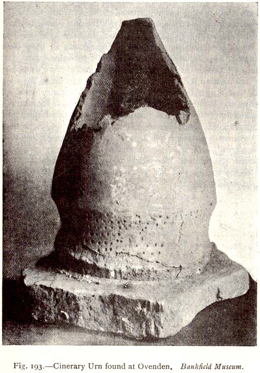
As with a number of prehistoric burials in the Halifax district, there is no longer any trace of the original site here. It was a place that I wrongly attributed as being a dolmen in my early survey on West Yorkshire’s megalithic remains (Bennett 1994) — but at least I got the prehistoric tomb part of it right! It was first found, quite accidentally, in February of 1877, when a grave-digger working in the grounds of the Mount Zion Chapel at Ovenden (as it was known in them days) hit upon a large stone beneath the earth he was digging. Thankfully the grave-digger was a conscientious chap and, instead of just digging up the obstruction, decided to inform others of his discovery. A temporary halt was made on his grave-digging and thereafter a careful dig was organized to explore what he’d found. Some years later an account of the discovery was reported in H. Ling Roth’s (1906) work on the history of Halifax, where he told:
“On digging about 2ft (61cm) below the surface of the ground, a slab of stone impeded the work, and on its removal, a square cavity, formed of four upright stones, was discovered, in which the urn had been placed bottom upwards (see old photo, PB), and the mausoleum filled with gravel… The urn had not been disturbed since its removal from its present site, but still remains on its original base: a rude stone which formed the floor of its ancient sepulchre. The urn measured when first discovered 19in (48cm) in height by 13in (32.5cm) in diameter at its orifice, but only 4in (10.2cm) at its base. Below its rim it has the usual curved division which is here ornamented with dots made with a pointed instrument when the clay was in a soft state.”
Mr Roth went on to tell how a Dr Dolan of Halifax examined the broken bones and contents within the urn and found them to be human. Intriguingly it seems there was some evidence of prehistoric dental practice from the remains! Dr Dolan told:
“There is unmistakable evidence on this point from some of the bones of the skull, particularly from the preserved portions of the petrous part of the temporal bone showing meatus auditorius, from the right malar bone, and from fragments of the flat bones of the cranium. The teeth offer confirmatory evidence. I have found several which had evidently been subjected to great heat, as they were completely calcined. But there was one which had been only partially burnt, the burnt part being quite black; and another, unburnt, which seems to have dropped from the jaw before the fire had reached it. One of the teeth seems to me to have been ‘stopped’, and this opens out a question whether the art of dentistry was known to the inhabitants before the Roman invasion. From the size and structure of the bones, I believe the majority of them to have belonged to a female of adult age. There are certain bones, particularly some phalanges, which seem to me to be those of a child. As we do not however possess the whole of the original contents of the urn — much having been extracted from it on its discovery — there may probably have been, when first interred, the relics of others than those we at present possess.”
The remains of the urn were eventually presented to the care of the Bankfield Museum by the Halifax antiquary, F.A. Leyland.
A definitive account of this little-known site was recently published by Raymond Varley (2021), and all interested readers can refer to his work here.
References:
Bennett, Paul, Circles, Standing Stones and Legendary Rocks of West Yorkshire, Heart of Albion Press: Loughborough 1994.
Leyland, F.A., The History and Antiquities of the Parish of Halifax, by the Reverend John Watson, M.A., R.Leyland: Halifax n.d. (c.1867)
Roth, H. Ling, The Yorkshire Coiners, 1767-1783; and Notes on Old and Prehistoric Halifax, F.King: Halifax 1906.


")
 - plan")


")

")