Take the directions as if you’re visiting the ornate petroglyphs known asthe Lunar Stone and the Spotted Stone. Walk past them and down the slope, NW, as if you’re heading to the small valley a few hundred yards away. As you reach the bottom of the slope, closer to the stream, a large boulder catches your attention. This carved stone is just a few yards before you reach it.
Archaeology & History
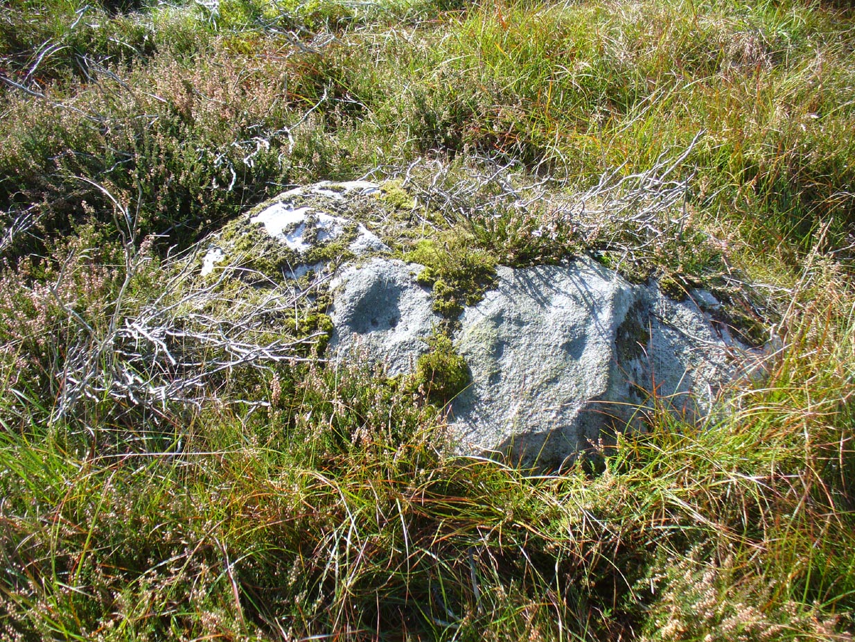
This simple cup-marked design below the northern slope of Stanbury Hill has, on its northeastern sloping face, a single cup-mark; then, past a curiously-etched line (probably more recent) is a larger circular feature, like a very shallow ‘bowl’ as in the one found in the superb Stag Cottage petroglyph complex 300 miles north (and several other carvings). A few yards away, a large single cup-mark has been etched onto another stone. As with quite a few carvings in this region, they have been missed in the standard archaeocentric surveys.
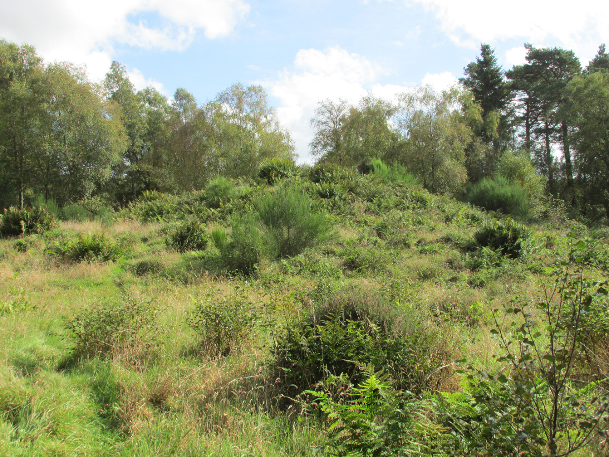
Travelling north on the Bridgemill to Fettercairn road, park at the layby just before the junction with the minor road (left) through the Forestry Commission’s Inverury Wood. Go through the gate and walk along the track to the end where it joins another track and turn right. About 300 yards along, the Hillock is in a fenced enclosure to the right, accessible over a stile.
Archaeology & History
The site was not mentioned in the Statistical Accounts, nor is the origin of the name recalled, from which it is reasonable to assume that ‘witches’ (howsoever that term was interpreted in the days of persecution by the Kirk Sessions) met there. This is reinforced by there being a plot of land due west called ‘Witchfield’. The Canmore report describes the mound as being,
“situated near the edge of a low natural escarpment..measuring about 18m. in diameter and 2m. high.”
The Ordnance Survey reported in the mid-1860s that the Hillock was,
“An artificial mound….a remarkable looking object….enclosed with ornamental wire fencing, the name is well known in the district, but is not mentioned in the Statistical account nor any other document in the possession of the authorities. James Glenny, Gardener at Inglismaldie states that he assisted to open this, under directions from the Earl of Kintore, about Seven years ago, and that after clearing away the top soil there were found several stone coffins containing human bones and a clay urn containing what appeared to be calcined human bones….”
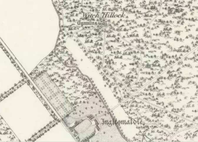
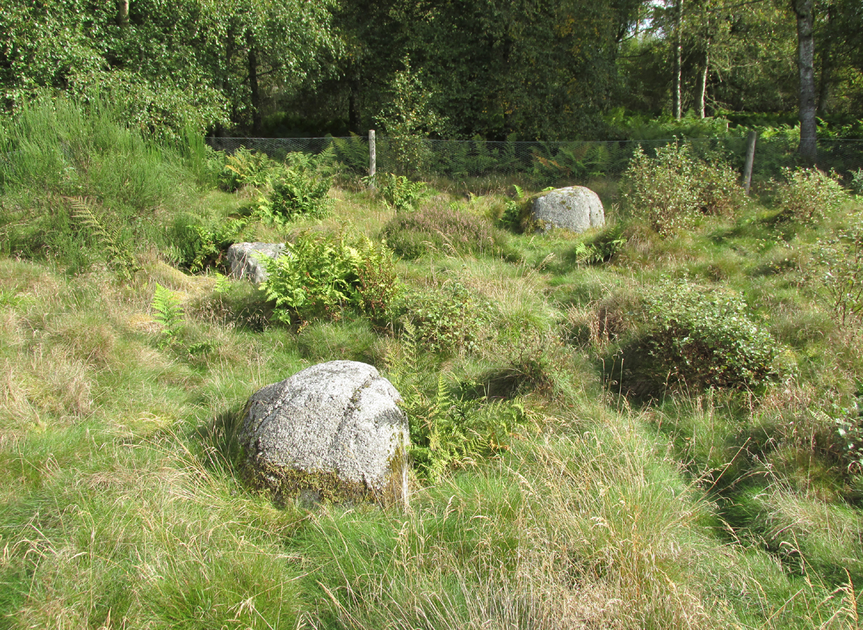
The site shown at the top of the 1865 6″ OS Map.The Hillock with 3 stones in the foreground
Another remarkable feature of the Hillock enclosure is an arc of three large earth fast boulders to the north-west of the mound. It has the appearance of being an incomplete, possibly four poster circle. The stones are not listed by Aubrey Burl (2000) as being part of a circle, and if indeed it was a circle there doesn’t seem to be any evidence of the fourth stone, which would have been positioned nearest to the Hillock. Unless the Hillock was imagined to be the ‘missing’ fourth stone.
Three stones – once part of a circle?
A ‘well’ is shown on the modern OS map in the corner of the enclosure nearest the stile, but there was no evidence of this on the day of my visit.
Despite its rather remote location, it was noticeable by the well trodden state of the long grass on the day of my visit that the site receives quite a few visitors – a venue still for witches?
References:
Burl, Aubrey, The Stone Circles of Britain, Ireland and Brittany, Yale University Press 2000.
Royal Commission on the Ancient and Historical Monuments of Scotland, The Archaeological Sites & Monuments of South Kincardine, Kincardine and Deeside District, HMSO: Edinburgh 1982.
From Kenmore, take the minor road on the south-side of Loch Tay for 1½ miles (2.4km) until you reach the hamlet of Acharn. From here take the track uphill for ½-mile past the Acharn waterfalls and follow the same route to the Acharn Burn tumulus. Walk past here along the track and, just before you reach the wooded burn, bear right and walk uphill for nearly another half-mile, roughly parallel to the Allt Mhucaidh (Remony Burn). As you reach the proper moorland, you’ll see the stones rising up!
Archaeology & History
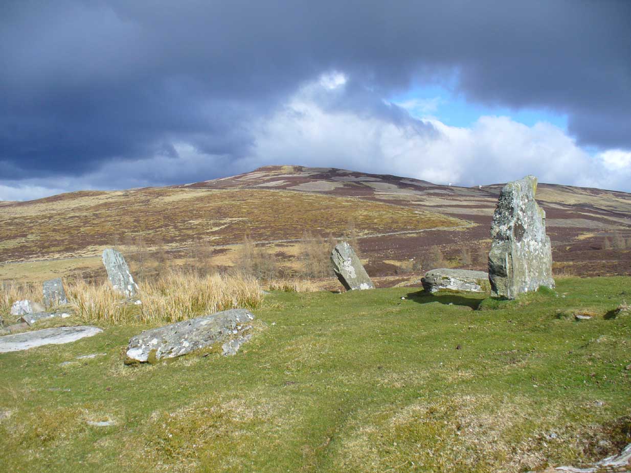
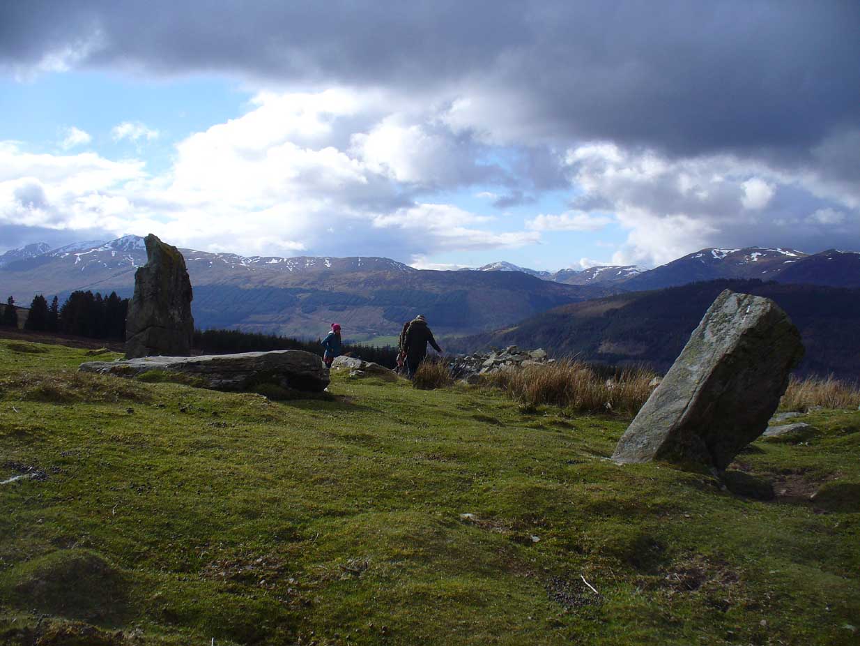
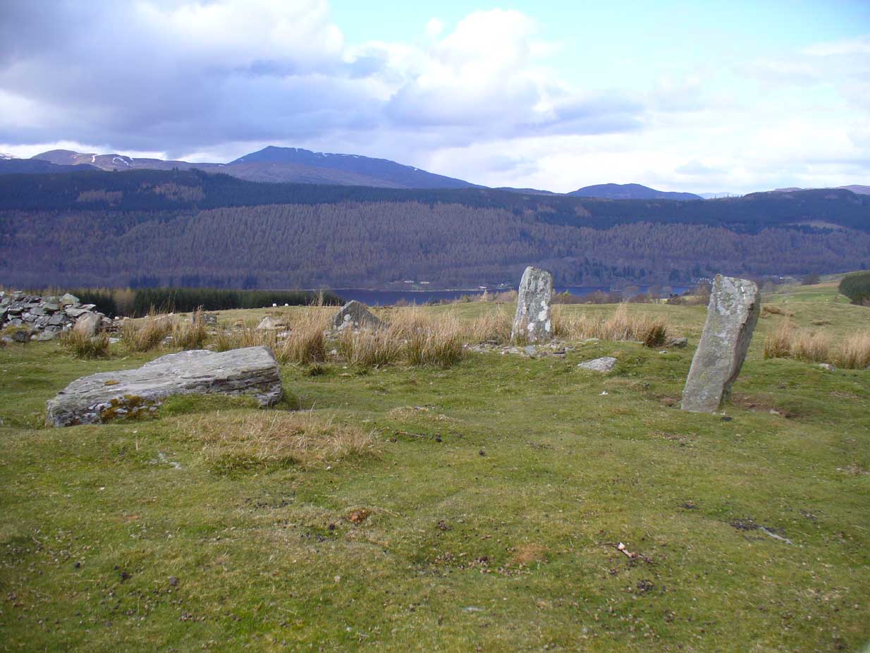
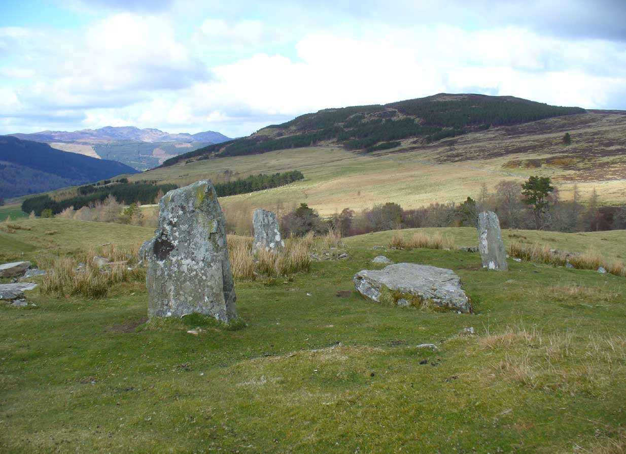
This is quite a spectacular site! Not for the size of the stones or the arrangement of the megaliths, but for the setting! It’s outstanding! When a bunch of us wandered up here a few months ago, snow was still on the peaks and Nature was giving us a real mix of Her colours and breath in a very changeable part of Her season. Twas gorgeous. Perhaps the setting was the thing which has kept the circle pretty quiet until recent years. It’s high up – and out of season the freezing winds and driving rains would keep all but the healthiest of crazy-folk away. We all only wished we’d have had more time here. But that aside…
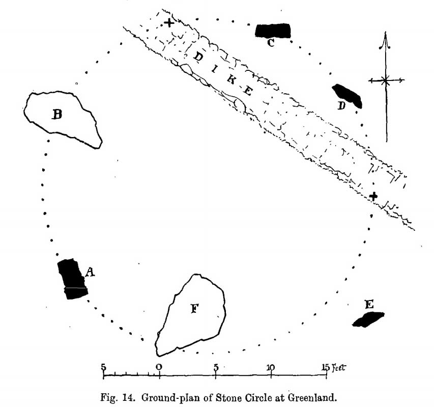
Lara between the old stonesJ.D. MacLeod’s 1909 groundplan
Along with the changeable weather She gives up here, the literary-types have given this circle changeable names too. Nowadays known as the Acharn Falls stone circle, in truth that’s a mile away and lacks in both visual and geographical accuracy. ‘Greenland’ was the name cited when J.B. MacKenzie (1909) wrote about it more than a hundred years back, and it’s the name we find in Mr Burl’s (2000) magnum opus, despite him telling how “a local name for it is Auchliacha, ‘the field of stones'” (Burl 1995), so perhaps we should adhere to what the locals say (my preference generally).
The atmospheric ring, looking WGreenland Circle, looking N
The ring is in quite a mess, having had a drystone wall built through it in the last 100 years. No walling is shown on the early Ordnance Survey maps, so some local land-owners (an english incomer?) was probably responsible. The stones used to stand in parts of the ancient forest, which must have looked and felt quite something before they ripped the trees away. It was hiding away in the woods when J.B. MacKenzie (1909) came here, shortly after the “modern wall” as he called it, had been constructed through the circle. He wrote:
“Six stones remain on the site, of which four are still erect and in position, and two are prostrate, one of which has apparently fallen inwards and the other outwards of the line of the circle, the diameter of which, touching the inner sides of the stones still standing, is 27 feet 9 inches. Mr MacLeod has supplied the following dimensions of the several stones:
A — 6 feet 9 inches x 3 feet 6 inches, lying flat
B — 8 feet 4 inches, in circumference at ground level
——1 foot 7 inches, high above the ground level
C — 6 feet 10 inches, in circumference at ground level
——4 feet 0 inches, high above ground level
D — 6 feet 0 inches, in circumference at ground level
——4 feet 3 inches, high above ground level
E — 7 feet 8 inches x 4 feet 6 inches, lying flat
F — 9 feet 0 inches, in circumference at ground level
——5 feet 8 inches, high above ground level.”
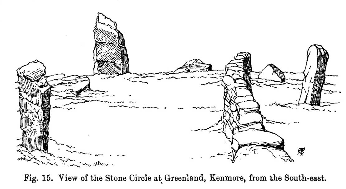
Coles’ 1910 sketch of the siteColes’ 1910 ground-plan
The year after MacKenzie’s notes, the great Fred Coles (1910) paid a visit here. Noting how high it was in the landscape compared to other megalithic rings in the region (it’s the highest known circle, at 1240 feet up), he went on to give his usual detailed appraisal, telling:
“In a little clearing amid these woods on Craggan Odhar, but disfigured by a dike which separates some of the Stones from the others, stands this Greenland Circle of which the ground-plan is given…. The Stones are six in number, of which four are erect, and they all appear to be of the quartzitic schist. Some disturbance has occurred, and it seems probable that there were at least two more Stones originally, one between B and C at the spot marked with a cross, and the other similarly marked midway between D and E. There is, however, no vestige of any Standing Stone in the sides of the dike itself.
“On the south-west is Stone A, the tallest, with pointed top, 5 feet 7 inches in height, oblong in contour, and measuring at the base 9 feet 5 inches. Having several deep horizontal fissures, this Stone…bears an odd resemblance to masonry. The next Stone, B, lies prostrate, measuring 7 feet 9 inches by 4 feet, and about 1 foot in thickness above ground. The little oblong Stone, C, on the other side of the dike, stands only 1 foot 10 inches above ground, and probably is a mere fragment—the stump of a much larger block. At D the Stone is 4 feet 3 inches in height, and is a very narrow slab-like piece; Stone E, which has a decided lean over towards the interior of the Circle, is 4 feet 2 inches high, and is in basal girth 6 feet 6 inches. Like the others, it is angular and thinnish in proportion to its breadth. Stone F measures 8 feet 2 inches by 5 feet 2 inches, and its position, with the narrow end resting almost on the circumference, suggests, as in other cases, the probability that it was this narrow end which was buried when the Stone was erected. These blocks were most likely brought from the low cliffy ledges near, for, as the name ‘Craggan Odhar’ implies, the place was, before being planted, conspicuous for its Grey Crags.”
Although no modern excavation has taken place, when the brilliant local historian William Gillies (1925) first got round to exploring the circle, he remedied that situation. In probing the ground beneath the surface when the weather conditions allowed, Mr Gillies found that there seemed to have been more standing stones in the circle than presently meets the eye. He wrote:
“I paid several visits last summer to this lonely and elevated spot, and examined the ground for stones, where the wide spaces between those indicated on the plan (see Coles’ 1910 drawing, above) suggested that others might be concealed beneath the turf. There would appear to be three stones missing, which would make the circle to consist of nine in all when it was entire. With little trouble, at a depth of only 3 inches, I located a large flat stone measuring 5 feet 6 inches by 4 feet 8 inches. It had stood on the north-western arc of the circle half-way between the fallen stone on the west and the broken standing stone on the north-north-west. It had fallen outwards. The foundation of the wall, built probably some seventy years ago to enclose the plantation, rested on the edge of the stone. The ground along the circumference of the circle between the three stones on the eastern side was carefully probed, but the rod touched only small loose stones.
“I next turned up the centre of the circle, and at a depth of 5 inches below the surface came upon a dark deposit. It extended over a space of 2 feet square and was about 5 inches in depth. It was mixed with a white limy substance consisting of calcined bones, bits of which along with a sample of the dark substance I brought to the Museum. A bit of charcoal from the deposit revealed the lines of cleavage in the wood. There is no peat at the spot, although the elevation, which is at least 1200 feet, might suggest it. The surrounding soil is of a reddish colour, and quite unlike the deposit which must have been placed there, and which was probably a burial after cremation.”
Greenland circle, looking NE
Gillies was exemplary in his exploration of sites that were on the verge of disappearing from tongue and text and we remain incredibly grateful for his later exposition on the antiquarian remains and legends of this truly stunning landscape. In Aubrey Burl’s (1995; 2000) respective summaries of this stone circle, as well as that of John Barnatt (1989), they ascribe the situation of it originally having 9 stones, as Gillies suggested.
Visit this site! If you’re into megaliths, you’ll bloody love it!
References:
Barnatt, John, Stone Circles of Britain – volume 2, BAR: Oxford 1989.
Burl, Aubrey, A Guide to the Stone Circles of Britain, Ireland and Brittany, Yale University Press 1995.
Burl, Aubrey, The Stone Circles of Britain, Ireland and Brittany, Yale University Press 2000.
Money, Bob, Scottish Rambles – Corners of Perthshire, Perth 1990.
Acknowledgements: Many thanks to the unholy bunch who helped travel, locate, photograph and take notes on the day of our visit here, including Aisha, Lara & Leo Domleo; Lisa & Fraser; Nina and Paul. Let’s do it again and check out the unrecorded stuff up there next time!
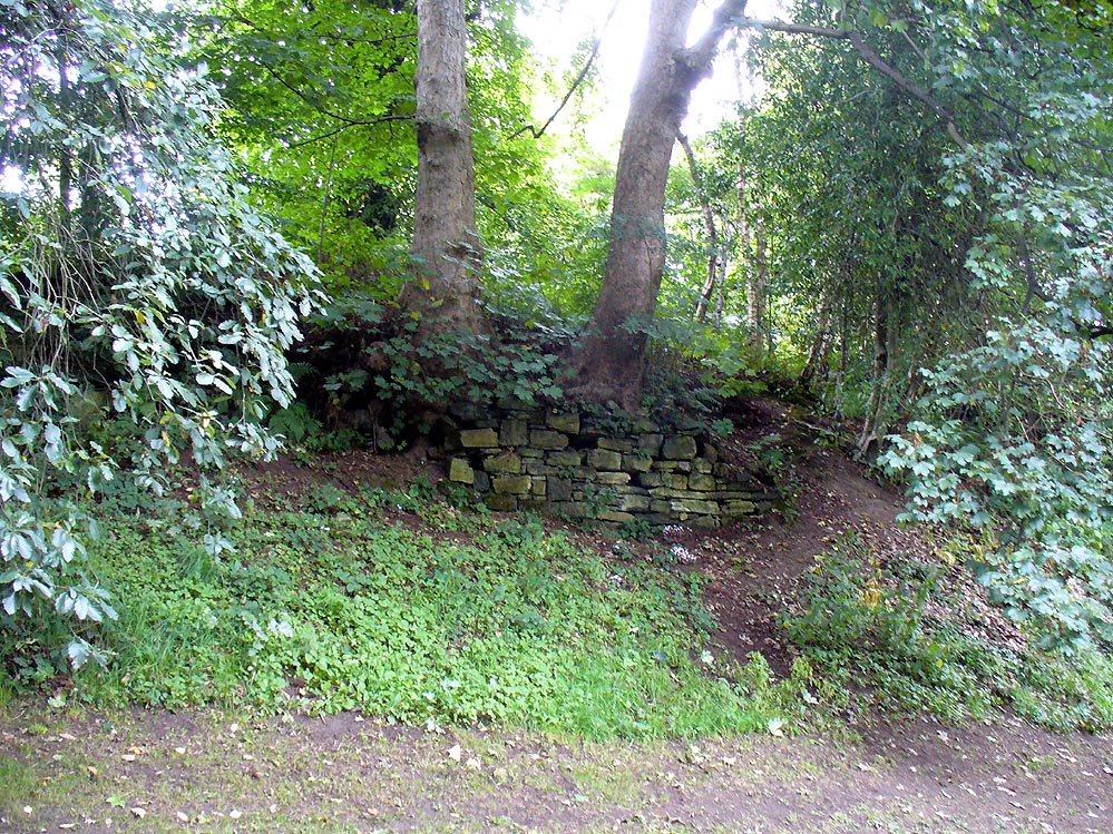
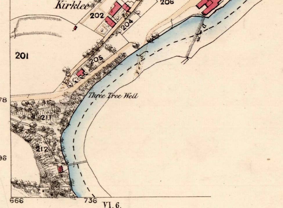
The demise of this old healing spring of water occurred a few generations ago by the look of things. Marked on the earliest Ordnance Survey maps—erroneously as the ‘Three Tree Well’, as Mr McDonald (1860) will soon explain—it was located on the west side of the River Kelvin, halfway between the Kirklee footbridge and the ancient ford, but the only remains we can see of it now appears to be the brick-walling above which a pair of sycamoretrees rise, or perhaps beneath the man-hole cover on the path lower down.
Three Tree Well on 1865 map
…But it wasn’t always this way… Known to be a chalybeate, or iron-bearing spring (which are always regarded as tonics in local lore, fortifying the blood general health), when the local writer Hugh McDonald (1860) wrote about it in his wonderful Rambles round Glasgow in the middle of the 19th century, he cast a picture of the area that few Glaswegians would recognise today—and a damn good swipe at the incomers trying to alter the names of traditional places:
“At the western extremity of the Botanic Gardens a narrow passage, in popular parlance called “the Kyber Pass,” leads over a green knoll to the volley of the Kelvin at the famous “Pear-tree Well.” …The scenery of the Kelvin in the vicinity of the Pear-tree Well is of the most romantic and beautiful description. The banks are bold, and in many places fringed with masses of foliage to the water-lip; while the rustic bridge, the lonely cottage, and the picturesque mill, seem planted by the very hand of taste, along the meanderings of the rippled and murmuring stream, wherever they are likely to produce a telling effect… Altogether the scene and its accessories present the very choicest of those harmonious combinations of colour and form which the landscape limner loves to gaze upon, and fondly endeavours, in the pride of his skill, to transfer to the living canvas. No wonder it is that Kelvin Grove has long been the favourite haunt of our City lovers, and the favourite theme of our local poets; for Nature has, indeed, strewn its recesses with charms as fresh and beautiful as though it were situated far from the dwellings of men, instead of almost under the wing of our most dinsome and dusky of towns.
“The Pear-tree Well issues from the bottom of a steep and thickly-wooded bank, which, at this point, rises gracefully from the rocky bed of the streamlet. The crystalline and deliciously cool water is collected into a considerable cavity in the earth; immediately over which three large trees—a plane and two handsome ashes—raise on high their umbrageous heads, while their sturdy roots, in serpent-like convolutions, twine around the watery hollow beneath, as if to defend it from the intrusion of the penetrating noonday sun. Some suppose that it is from this trio of sylvan guardians that the fountain has received its name — and that the ‘Three-tree’ and not the ‘Pear-tree’ Well is its proper denomination. The advocates of the latter theory further remark, that there is no pear-tree in the vicinity, and that consequently the popular name is probably but a corruption of “Three-tree.” There is high authority for saying that names are things of slight consequence; but however that may be, we are inclined, in the present instance, to be conservative of the old name for this favourite well, and to retain it in spite of all attempts at innovation. Whether from langsyne associations or not, we shall not attempt to discover, but Pear-tree Well sounds most musically on our ear — and we should be loath to have it suppressed by the word-coinage of any crotchety theorist; and besides, who can tell what kind of trees may have formerly graced the locality? A perfect orchard of the pear tribe may, at some past period, have clothed the banks of Kelvin for anything that these violators of a time-honoured name—”these men who are given to change”—know to the contrary. No, no! Pear-tree Well it has been, and Pear-tree Well to us, at least, it must remain. We had as lief meet an old friend with a new face, as an old haunt with a new name.
“Having done our devoirs to the spirit of the fountain, by draining a bicker of the translucent water, which, by the way, is slightly impregnated with iron, we sit ourselves down on the bank above, under the ashen tree, when one of two friends with whose company we have been honoured, inspired by the half-gelid beverage, bursts suddenly out with—
“Let us haste to Kelvin Grove, bonnie lassie, O.”
“We of course join heartily in the measure, which has for many years been highly popular in the west of Scotland, and which we naturally enjoy with double zest, amid the scenery to which it refers…”
Pear Tree Well in 1896
The great historian and romantic, J.A. Hammerton (1920) even passed here, telling how sufferers of disease relied upon its curing waters to heal them. It is just such a pity that this picturesque medicinal spring and its rivulet are with us no more…
References:
Brotchie, T.C.F., Glasgow Rivers and Streams: Their Legend and Lore, John Maclehose: Glasgow 1914.
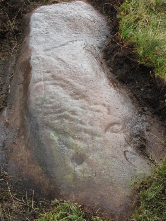
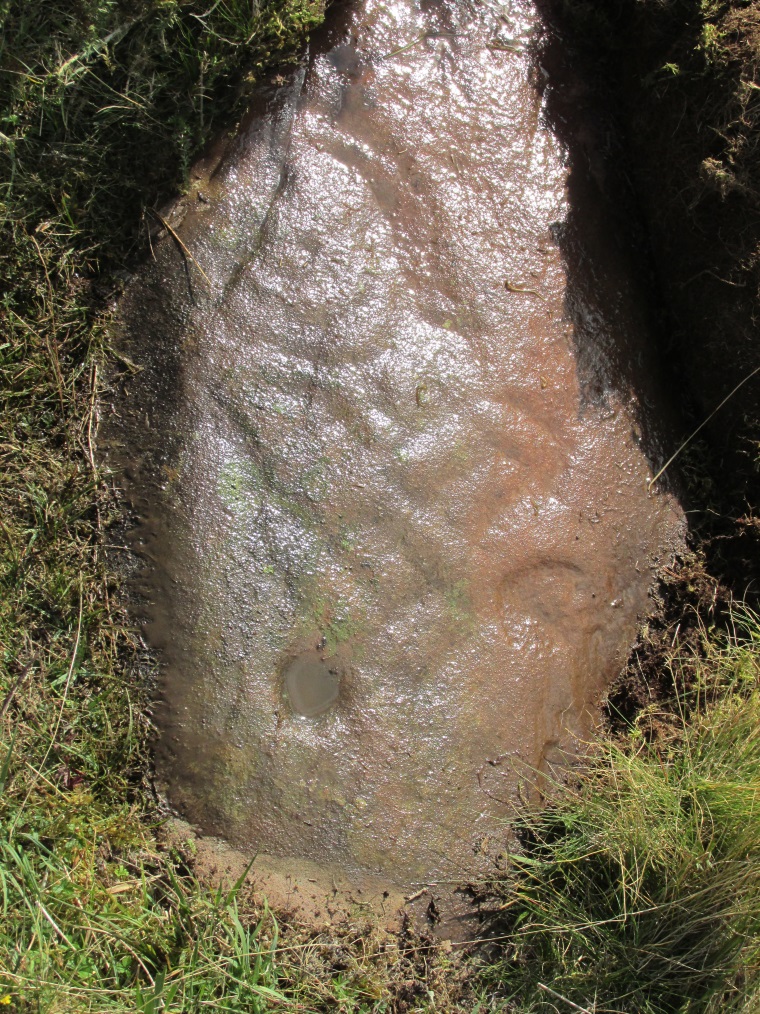
Take the same directions to locate the cup-and-ring stone of Ballochraggan 12. There are several rocks adjacent. The one immediately next to it, to the northeast, is the one you’re looking for. Be gentle and careful if you’re gonna look at it — deadly serious, be very careful indeed!
Archaeology & History
One of the most intriguing and most fascinating of all the prehistoric carvings I’ve yet to discover. Not that this was all my own work. If it hadn’t been for Paul Hornby, we might have simply walked past it as being little more than a single cup-marked stone—and in this area, single cup-marks tend to be little more than geological in nature.
After we’d looked over several of the registered carvings close by, I did my usual meandering back and forth, stroking stones and seeing if there were any carvings that had been missed by previous surveyors. And in walking past a small piece of smooth rock, a singular cupmark seemed to stand out. I walked past it, shouting across to my colleague.
“It looks like we’ve got a single cup-mark here Paul,” I said, “with possible half-ring.” Thankfully Mr Hornby gave it his better attention.
Mask Stone, with faint ‘urn’Close-up of features
The sun was still out and shining across the smooth rock surface, which tends to mean that you’re not seeing any carving on the stone quite as good as it actually is. Thankfully however, the sun was beginning to get lower and, when this happens, if we wet the rock, any carvings that might be there stand out much better. And this little fella just seemed to get better and more curious the more attention Paul gave it!
The first thing that became obvious were a series of faint carved lines above the single cup-mark. Initially these didn’t seem to merit much attention (straight lines on rock are usually more the product of geophysical action than that of humans), but as the rock got wetter, Paul saw something very distinct indeed.
“There’s a face on it!” he exclaimed. And indeed there was. A Rorschach response no doubt, but it was still very much like a face. This looked for all the world akin to the stylised olde English gentry sort of countenance, as in old cartoons. It was quite ‘distinct’, as such characters themselves insist on being! Yet around this initial face, more lines seemed to be emerging as the stone gave up more and more of its hidden story.
Standing back from an initial investigation, the carving was seen to consist of a triple-ring, but without the traditional ‘cup’ in its centre. Instead, the centre was marked simply by a small ‘dot’—perhaps, originally, being a small conglomerate hole formed as a result of another tiny harder fragment of stone falling away from its larger mass. But a ‘dot’ it was. The other carved ‘lines’ however, immediately below and attached to the triple-ring, gave us something almost unique—and another strong Rorschach response. As the photos clearly show, we have a distinct second ‘face’ made up of the same lines but in a quite different form. This ‘face’ has all the attributes we usually associate with pictures of mythical spirits, demons, or a mask—hence the name!
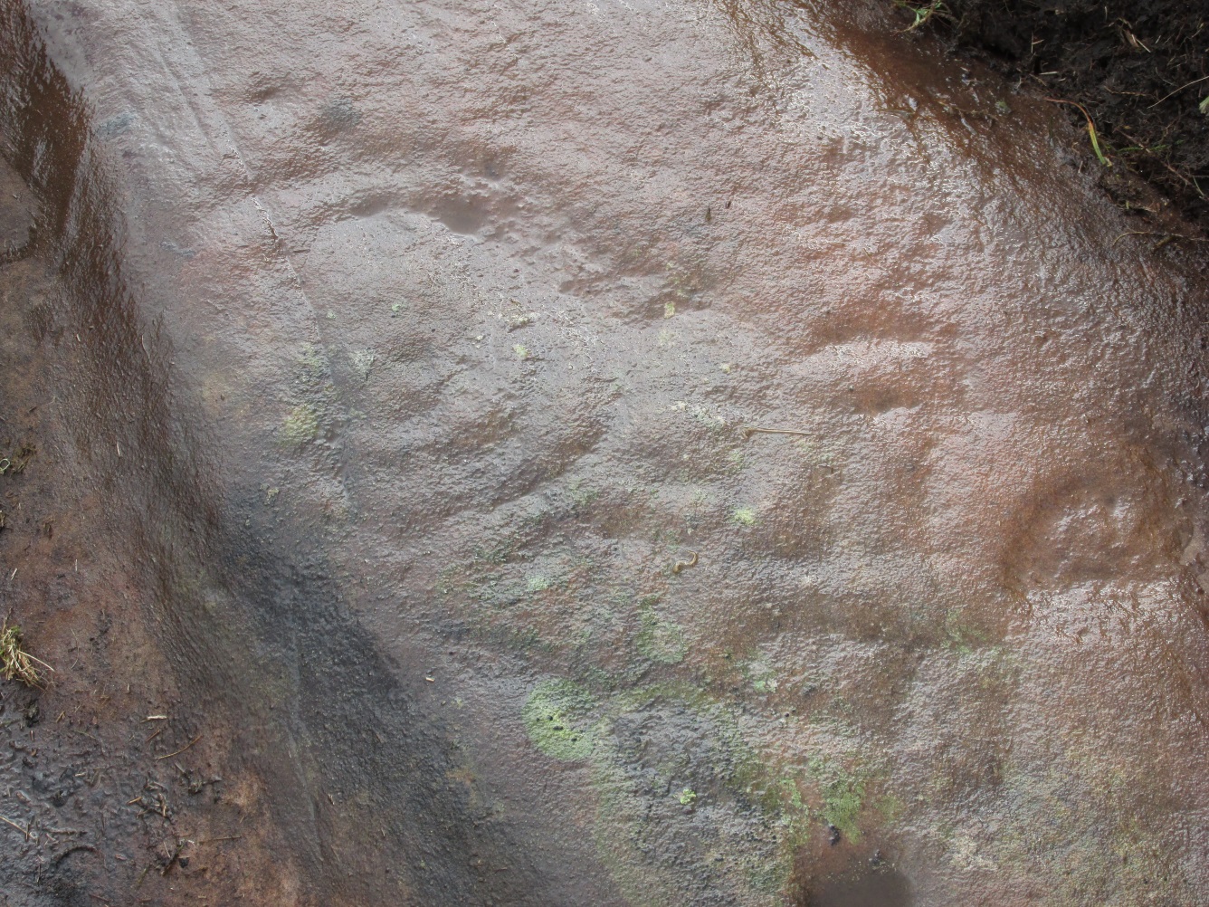
Paul took a series of fine photos, hoping that he could catch the image that our eyes could clearly see. And thankfully, his digital camera brought the image to life even better than our eyes did! The ‘mask’ is comprised of carved lozenge forms, akin to the more decorative ones we find at Kilmartin, and more especially around Newgrange, Ireland. We sat and talked about this: wondering and working out routes that we’d take over mountains and moors, from Ireland, to Kilmartin, then onto Ballochraggan, etching the same designs onto the rocks hereby and attaching similar mythic notions to them: of shamanism and kingship; underworlds and journeys—paradigms lost and certainly misunderstood in the non-polysemia of many modern academics.
Lozenges and rings
…The stone here was still slightly covered over and, beneath the loose grasses, another feature emerged of another petroglyphic rarity. At the topmost western side of the rock a straight line ran across the surface, seemingly marked by the hand of man, with a curious little line almost doubling back on itself for just an inch or so, and then feeling to run down the stone, towards the concentric rings and the face below. When we stood back and took the photos, this line and its tracer took on a form that I’ve only seen echoed in one of the Netherlargie tombs at Kilmartin, Argyll, 44.4 miles (73km) to the west. It is very distinct.
The beaker, rings & ‘face’
Spuriously ascribed as being ‘axe’ carvings (oh how archaeologists love this Rorschach projection), the Netherlargie North tomb cover-stone in Kilmartin has a series of burial ‘urns’ or beakers carved onto the rock, amidst a scattered collection of cup markings. (Beckensall 2005:73-4; Bradley 1983:92-3; Royal Commission 1971:68-70; Twohig 1972, etc) Here too at Ballochraggan we find another such symbol, but just a singular example, much larger and more clearly a beaker or urn, as are traditionally found within many old neolithic and Bronze Age tombs; although no tomb is immediately apparent at this Ballochraggan carving.
The entire carving is very faint indeed (you can’t even see it when you’re looking directly at it unless conditions are good) showing that it remained open to the elements for thousands of years. Other adjacent carvings lack the erosion that we find on this one, even on those which, as archaeologist Lisa Samson said, is “softer sandstone rock than this one”—implying that it’s one of the older carvings in this incredible cluster.
References:
Beckensall, Stan, The Prehistoric Rock Art of Kilmartin, Kilmartin Trust: Kilmartin 2005.
Bradley, Richard, Altering the Earth, Society of Antiquaries Scotland: Edinburgh 1993.
Royal Commission on the Ancient & Historical Monuments of Scotland, Argyll – volume 6: Mid-Argyll and Cowal, HMSO: Edinburgh 1971.
Twohig, Elizabeth Shee, The Megalithic Art of Western Europe, Clarendon: Oxford 1981.
Acknowledgments: Huge thanks again to Mr Paul Hornby for his considerable help with this site, and for use of his photos.
From the main road running through lovely Comrie, take the south B827 road over the old river bridge. Go dead straight for several hundred yards until the road bends right; but take the left turn here. 100 yards or so along note the trees on your right, and the road begins to swerve round here. Just round the corner in the trees, the stones are in the clearing right by the roadside. You can’t miss them! (if you hit the graveyard, you’ve gone past them)
Archaeology & History
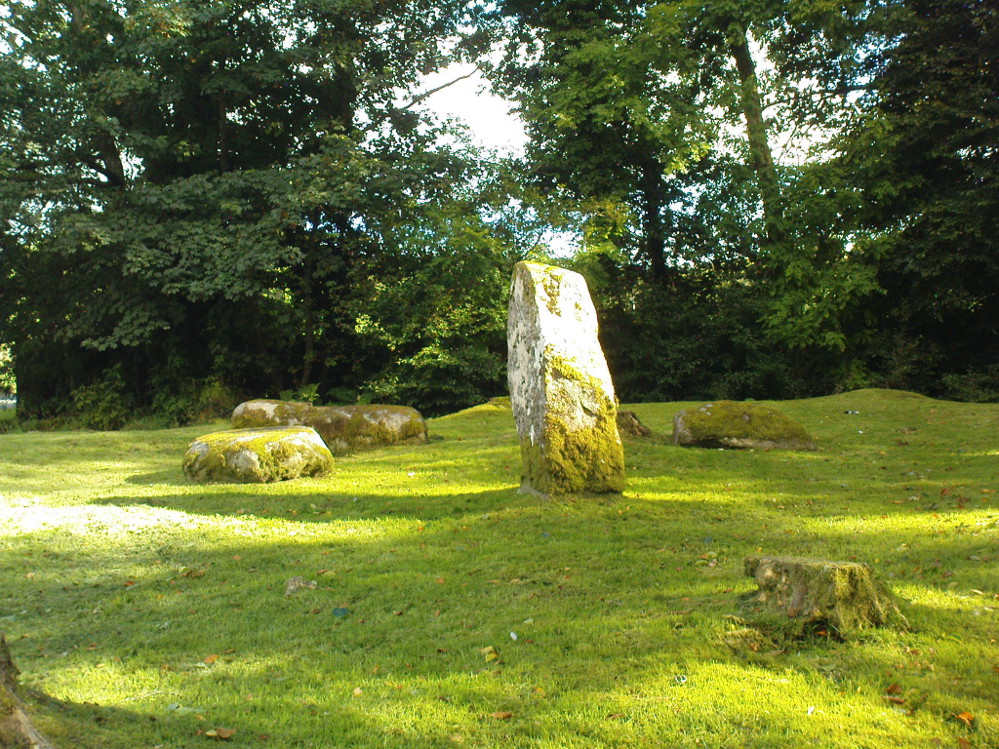
This is a truly lovely, almost warming enclosed megalithic site—albeit damaged by the ruin of centuries; but on the occasions I’ve been here it feels quite nurturing and elicits a quite natural meditative state. Whether or not this is due to the surround of trees, or the natural electromagnetic field, or just me, I dunno….
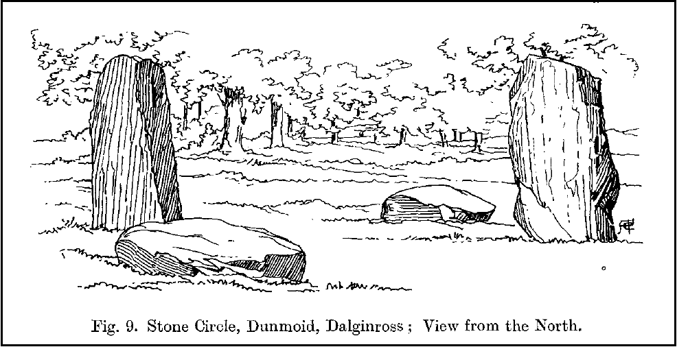
Dunmoid Circle, looking SEDunmoid from the North (Coles 1911)
The ‘circle’ is constructed upon a flat rounded section of ground, surrounded by a ditch on two-thirds of its edges, very reminiscent of a typical henge monument—but there is no mention of this in modern surveys. One of the earliest accounts of Dunmoid was written by John MacPherson (1896) who gave us as much of the known history of the site as is still known by any modern academic. He wrote:
“At the west side of the new cemetery, close to the public road, there is a curious round knoll, which at one time must have been used as a place for the burial of the dead. The attention of the writer of this was drawn to it about twenty years ago. There were three large slabs of stone lying upon the ground, which apparently had been at some former period placed erect by some loving hands to mark the last resting-place of some departed friend or hero. By the aid of some of the Comrie masons the stones were placed in a standing position. Curious to know what lay beneath the surface, we dug up the earth in front of the largest slab, and came upon a stone cist placed north and south, 7 inches long, 1 foot 8 inches broad, and 1 foot 3 inches deep. The only remains discovered was a thigh-bone, but whether it at one time formed a part of the leg of a Celt, a Roman, or a Saxon we could not tell. An old man who then lived in the village of Comrie told us that in his young days the same mound was dug up, when an urn filled with ashes was discovered. This, perhaps, would indicate that it formed a place of burial for Romans rather than for Caledonians. The spot is called Dunmoid, or ‘hill of judgment.'”
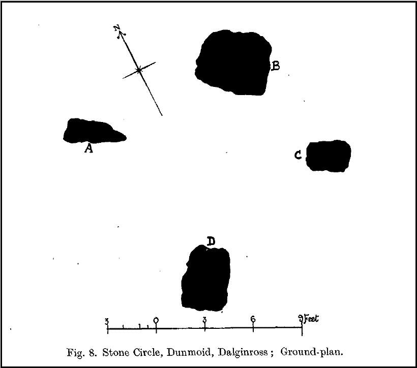
Fred Coles 1991 planDunmoid from SE (Coles 1911)
The circle gained the attention of the prolific Fred Coles (1911) in his Perthshire surveys, whose drawings and measurements are still repeated in the modern textbooks more than a century later. When he visited the site, two of the stones were still upright, but today only one still stands. In Aubrey Burl’s (1988) survey on ‘four-poster’ stone circles, he reiterated Coles’ words, telling:
“Originally four stone stood at the corners of a rectangle on a mound some 75ft (23m) across and 2ft (60cm) high. Coles’ plan showed the NW stone standing 5ft 4ins (1.6m) high and the SE, opposite, 5ft 2ins (1.6m), with the thick NW stone prostrate, 4ft 6ins (1.4m) long, with the more slender SW pillar also supine and 4ft (1.2m) long. The longer SE and NW sides of the oblong were roughly 9ft 6ins (2.9m) long and the others 9ft (2.7m) in length. The circle on which the stones had been placed had a diameter 13ft 2ins (4m), of which the Megalithic Yard is not an integer.”
The circle is included in Andrew Finlayson’s (2010) modern survey of the region.
References:
Burl, Aubrey, Four Posters: Bronze Age Stone Circles of Western Europe, BAR 195: Oxford 1988.
Finlayson, Andrew, The Stones of Strathearn, One Tree Island: Comrie 2010.
Hunter, John (Ed.), Chronicles of Strathearn, David Philips: Crieff 1896.
Hutchison, A.F., “The Standing Stones of Stirling District,” in The Stirling Antiquary, volume 1, 1893.
MacPherson, John, “At the Head of Strathearn,” in Chronicles of Strathearn, Crieff 1896.
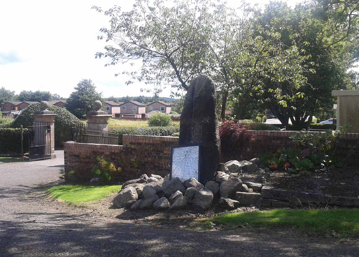
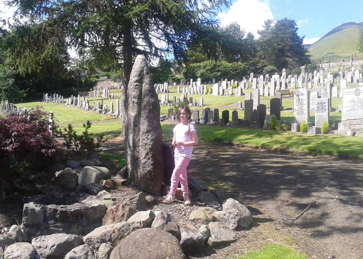
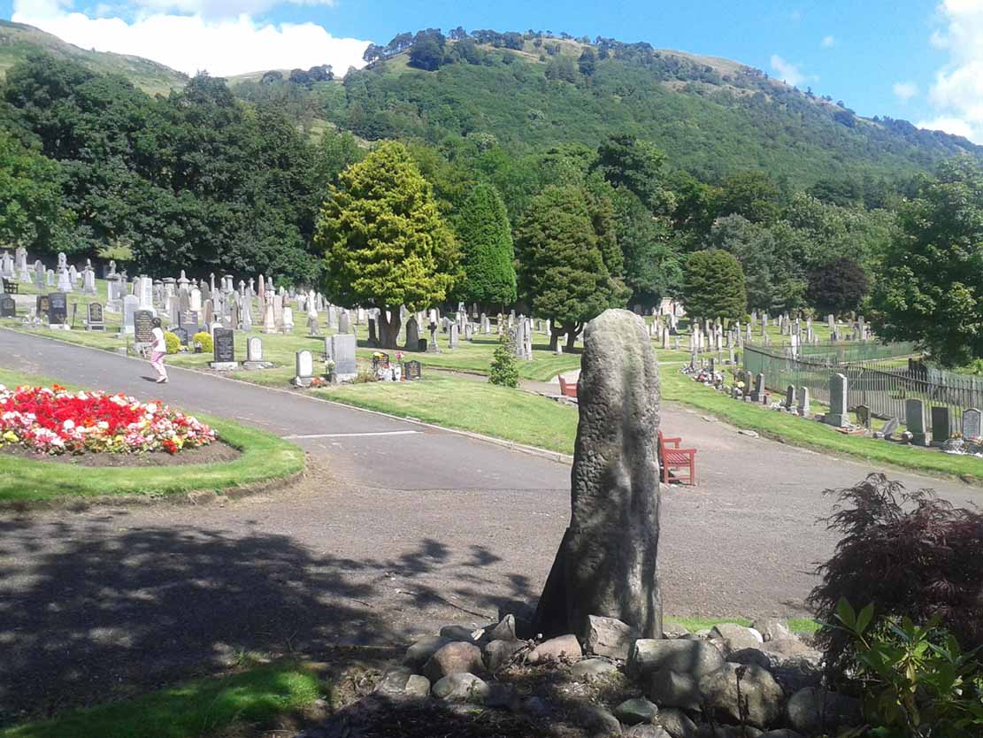
Go on the A91 through Alva, eastwards, and just before you go out of the town, note the small road on your left up to the graveyard. As you go into the graveyard, keep your eyes peeled on your left-hand side. You can’t really miss it!
Archaeology & History
Reported as “lost” or “destroyed” in many official reports, one of at least two standing stones that were reported in the Old Statistical Account of 1795 can still be found at the bottom of the graveyard, adjacent to the old holy well of St. Serf, at the edge of Alva town Very little has been written about it, and when it was mentioned in the OSA, the stones were only added in a foot note to the impressive stone cross on the outskirts of Alloa, saying:
“There are two stones resembling this one, in the neighbouring parish of Alva, at no great distance from the church, but not close to one another. They are both near the foot of the Ochils.”
A little person by its sideFrom the stone, looking NE
When some of the lads from the Scottish Royal Commission came here in July 1927, they could find no remains of any such standing stones and simply reported that they “no longer exist.” However, as visitors can plainly see, a tall upright standing stone still remains here, albeit repositioned by the good local people of Alva several decades ago. Standing more than seven-feet tall, the stone is very weather-worn on one side, with a plaque at the bottom.
References:
Royal Commission on the Ancient & Historical Monuments, Scotland, Inventory of Monuments and Constructions in the Counties of Fife, Kinross and Clackmannan, HMSO: Edinburgh 1933.
Liz Sykes, Saul and I wandered up to see this lovely spot a few years ago, to be found perched upon the top of the grassy boggy ridge a few hundred yards southeast of the Kerrycrusach houses (a coupla miles south of Rothesay, down the B881, on your left-hand [east] side). There are a few easy ways to get up here and it’s a nice amble, though you’ll get yer legs pretty wet if She’s been raining!
Archaeology & History
It was pouring with rain when I visited this small round tumulus with Liz, but a damn good view opened 360-degrees all round us when we hit the spot, the old tomb talking with others scattered on a select few hilltops from here: an obviously important ingredient to those who put it here. Mentioned only briefly in Marshall’s (1978) archaeological survey as being “seen on the skyline looking south from the West Road,” one side of the tomb had fallen away slightly, revealing numerous large pieces of quartz rocks in the construction: another obviously important ingredient (for whatever reason) to the doods who built it. The tomb, deemed as Bronze Age by Marshall, is about 3-4 feet high above the moorland and about forty feet across. Although this tomb officially sits alone here, it’s likely there are other sites close by that have yet to be found.
If little Saul (7 year-old at the time) wouldn’t have been all freezing and saturated and dying to get back home, I’d have sat on top of this old tomb for quite sometime. Twas a fine feeling: hills talking with hills, tombs with tombs, and a soaking-wet Paulus breathing the tranquility of it all.
References:
Marshall, Dorothy N., History of Bute, Bute Museum 1978.
Links:
RCAHMS: Kerrycrusach, Scoulag Moor, Bute – The archaeological info on this old tomb, from the hallowed database of the Royal Commission for Ancient & Historic Monuments, Scotland.
Two real ways to get here. Either (i) follow the directions to get to the Stag Cottage carvings of Duncroisk 1, then walk down to the fence by the riverside and walk along to the left for a coupla hundred yards till you reach a second metal fence-post sticking out of a rock on the other side of the deer-fencing; or (ii) from the roadside burn a coupla hundred yards along the road before you reach Stag Cottage, follow it down to the riverside, then head along the footpath behind the fencing, parallel with the river’s edge. It aint far. Within 100 yards you’ll reach the stone with the metal pole sticking out of it and the carvings are on this!
Archaeology & History
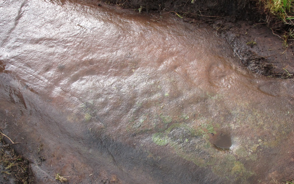
Confusingly redesignated as Duncroisk 5 carving by the usually efficient Canmore people, we’re sticking with this stone’s original name given by Ronald Morris (1981) in his British Archaeological Report of this and nearby carvings — and a quite fascinating carving this is as well!
C.G. Cash’s drawingDuncroisk 3 stone
As with many cup-and-rings, erosion and lighting has a powerful effect on seeing the design correctly. On my visit here in recent months there were quite distinct additional elements in the carving which haven’t been noted by previous archaeologists. But in saying that, there were also some elements that were reported by the earliest antiquarians that proved difficult to see in the grey light of day when I was here. The earliest report of the carving by C.G. Cash (1912) told there to be five rings, whereas today only 3 or 4 are visible (though this will probably change when viewed in other lighting conditions).
When Mr Cash told of this stone in his essay on the antiquities of Killin it sounded as if it was lucky to have survived, as it had previously been dug out and left by the roadside, before then being reused by a local to fix a fence-post in! Mr Cash told us that the local,
“had used it as the foundation stone of the stretching post at the south end of the easternmost fence on the farm, and there I found it, near the brink of the river, buried in sand and turf. I cleared it and then in pouring rain crouched over it to make a hasty sketch. It bears eighteen cups, of which five are surrounded by rings. The largest cups are 2½ inches and the rings 6 inches in diameter.”
Ron Morris’ images
When I visited the place the weather was much the same as Mr Cash described: lovely teeming rain, typical of the mountains, with the surrounding trees breathing moisture onto the slopes as ever.
Years later when Ronald Morris (1981) came here he saw “4 cups-and-one-ring…probably complete rings, up to 12cm (5 in) in diameters and 10 cups up to 2cm deep.”
If you stand and face the stone, the cup-marking on its lower right side (see Morris’ old photo, above) has a pecked line running from it further to the right and down to the edge of the rock. You can clearly make it out on the top photo. This carved line also seemed to touch another carved line which can be seen running along the outer edge of the stone — although the poor light didn’t allow me to view this with absolute confidence. I’ll have another look at it again when I’m up in the area in May and hopefully confirm or deny it with greater confidence (and if anyone else gets here in the meantime, have a look and see what y’ think).
Travel up the B6265 (Skipton to Grassington road) for a mile, watching on the small hills on your left (western) side, and then take the left turn up to Sandy Beck. You can’t miss the place!
Archaeology & History
Rough Haw, looking west
My first view of this place was from the hills east of here, atop of one of the great rock outcrops on the edge of Embsay Moor. The very first impression it gave me was – “That’s a bloody hillfort!”: an obvious worked rounded hill, with ridges typical of such monuments. Subsequent investigation found that there were extensive remains of walling, more typical of the Iron Age period than the neolithic (which some modern archaeologists have proposed), clearly visible around the edges of this great hill. The structure of the site is similar in size and design to the remains at the nearby Horse Close Hill above Skipton, aswell as another (officially unknown) site closer to Keighley. A large overgrown cairn rests on the southern side of the hill, seemingly more of archaic import than a mere clearance or marker point. But I may be wrong…
Very notable at this site are the profusion of springs emerging from all round Rough Haw: the blood of seven such water sources comes from its edges on all sides and would obviously have been of some importance here.
References:
Dixon, John & Phillip, Journeys through Brigantia – volume 1: Walks in Craven, Airedale and Wharfedale, Aussteiger Publications: Barnoldswick 1990.