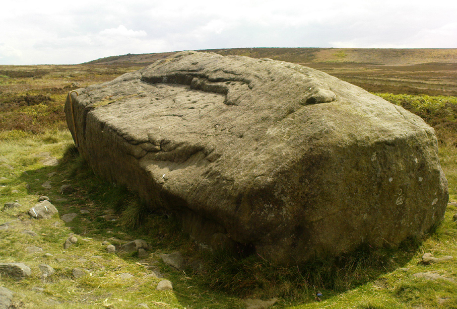
From East Morton village, take the moorland road, east, and up the steep hill. Where the road levels out there’s a right turn, plus (more importantly!) a trackway on your left which leads onto the moor. Go up this traclk and keep walking till you hit a moorland ‘footpath’ signpost. Stop here and walk due west (your left) onto the gently sloping rise of Stanbury Hill. Keep walking for a 250 yards or so, where the land has sloped gently down to the end of the spur; and just 50 yards before it drops down tot he stream below you’ll find a cluster of rocks scattered about. One of the stones here is this one!
Archaeology & History
This is an excellent carving first recorded, it seems, by Stuart Feather in 1977, as cited in the Yorkshire Archaeology Journal’s ‘Listings’ for 1978. It can be found some 27 yards west of a prehistoric cairn near the top of the ridge (14 yards east of the same cairn is the Spotted Stone carving).
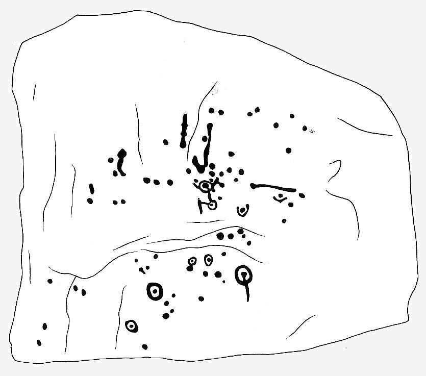
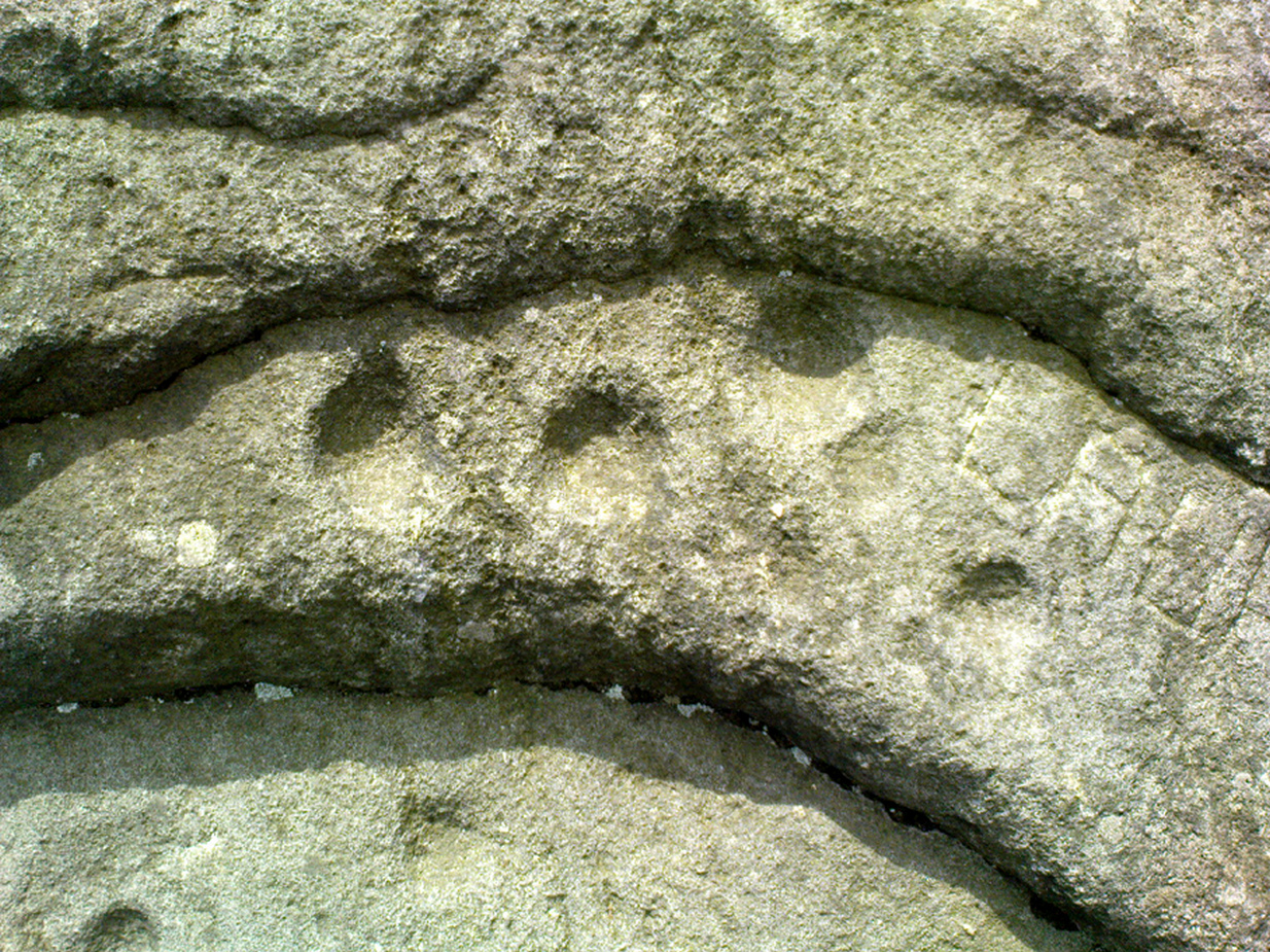
Lunar Stone carvingSoutheast section, with 3 cup-and-rings?
We have to assume that when Mr Feather first located this stone that the faint cup-and-rings on the topmost southeast section of the rock had been exposed to the elements from Day 1, so to speak: as the designs here are quite faint and well-worn. Another not unreasonable assumption is that Mr Feather then proceeded to dig away at the rest of the rock, exposing other features on the stone which had laid under the soil for countless centuries, as the northernmost part of the carving has minimal erosion effects on it. Indeed, unless this is true, we have to start thinking that the carving was made over quite lengthy periods of time, due solely to the greater and lesser effects of weathering on different sections of the stone.
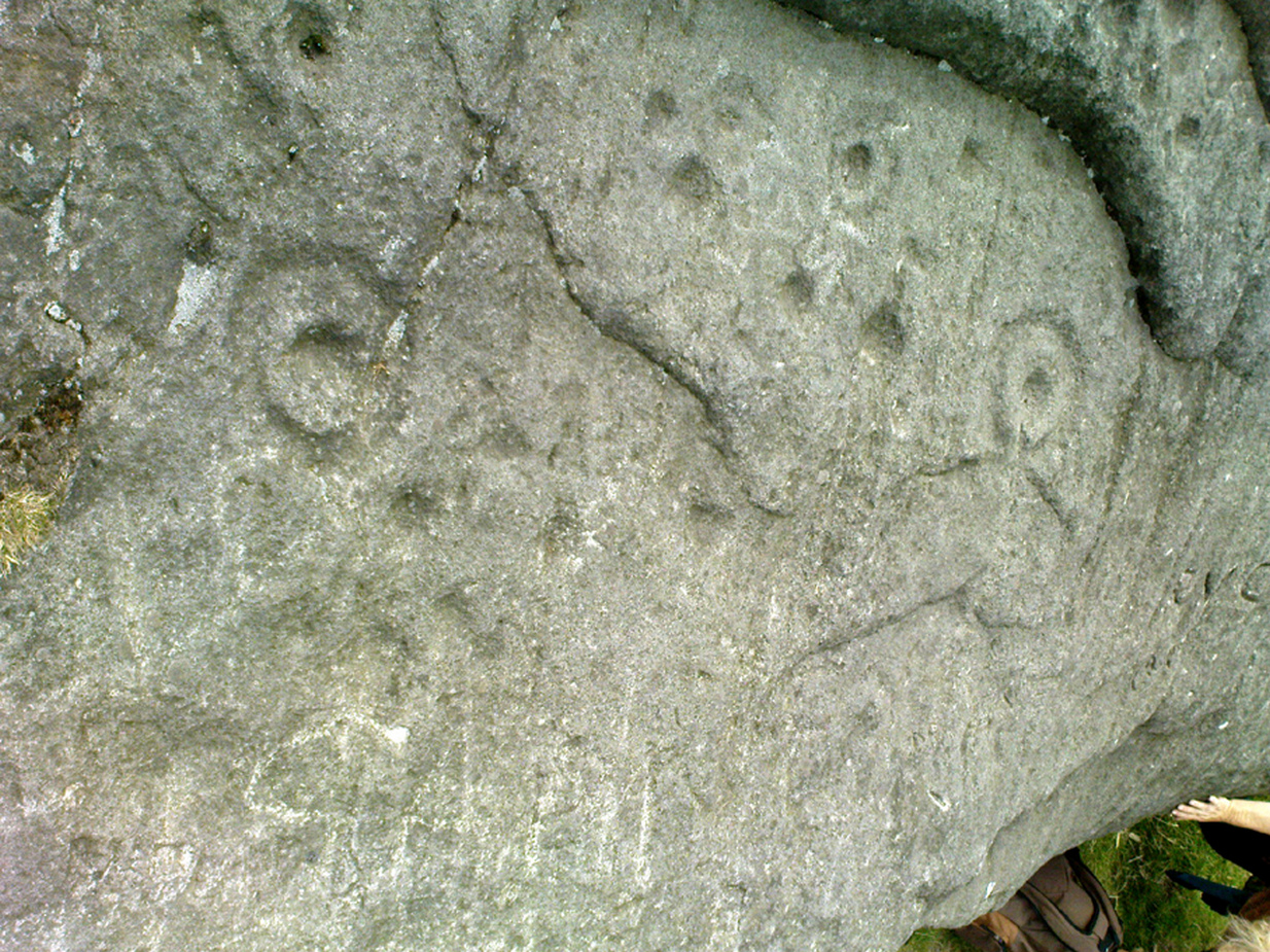
As seen in both the diagram and photos, this is a quite extravagent design. Consisting of several cup-and-rings, aswell as a double-ring, it is found amidst a small cluster of equally impressive, albeit very different carved rocks, all appearing to have a quite specific relationship with death and ritual. This and the other stones are found on the western end of a small serpentine ridge of land (Stanbury Hill), with streams flowing on the north and western sides and small remains of marshland to the south. The geomantic feature here, if relevant, relates to movements between the Earth, water, death and the setting sun: quite potent and important issues in the lives of the neolithic and Bronze Age peoples who lived hereby.
Northern section of carving – with calendrical cups?
The title of this stone carving — the Lunar Stone — should be quite evident: the design has all the hallmarks of celestial lunar movements around the ridge of the heavens; or here, pictured along the edges of the rock (symbolic of the firmament), upon and amidst which the moon travels in its rhythmic motion through the heavens. But don’t take that too seriously: it’s just an imaginative flutter that struck my otherwise distraught inability to know what I’m talking about!
References:
Hedges, John (ed.), The Carved Rocks of Rombald’s Moor, WYMCC: Wakefield 1986.
Head up to the Cow & Calf Rocks and walk to the large disused quarry round the back (west). You’ll notice a scattered copse of old pine trees on the edge where the hill slope drops back down towards Ilkley; and there, two raised hillocks (unquarried bits) rise up where the pine trees grow. The carvings are on the flat rocks atop of one of the two hillocks. If you’re walking up from Ilkley, once you’ve crossed the cattle-grid in the road and the moorland slope opens up above you, just walk uphill towards the copse of trees and watch out for the rock outcrop in the picture here.
Archaeology & History
Very well-known to locals, folklorists and archaeologists alike, the remains of these old glyphs have caught the attention of artists, historians and Forteans alike for the images and tales surrounding them. It was obvious that in times past, that the carved remains that we see today would have extended considerably further, but the quarrying destroyed much of it. Indeed, we’re lucky to have this small section of carved rock still intact!
The rocks were first described as the Hanging Stones in the local parish records of 1645, and their name probably derives from the old-english word hangra, meaning ‘a wood on a steep hill-side,’ which is very apt here. The first known description of the site as possessing cup-and-rings appears to have been in a small article in the local Leeds Mercury newspaper in 1871. Several years later J. Romilly Allen (1879) wrote a lengthier descripton of the site:
“The crags from which these masses have been detached are known by the name of hanging stones, and at their eastern extremity is a large quarry. Between this quarry and the overhanging edge of the cliff a portion of the horizontal surface of the rock was some years ago bared of turf, thereby disclosing the group of cup and ring sculptures shown on the accompanying drawing. It will be seen that the design consists of twenty-five cups of various sizes, from 1 to 3 inches in diameter. Seven of the cups are surrounded by incomplete rings, many of them being connected by an irregular arrangement of grooves. The pattern and execution are of such a rude nature as almost to suggest the idea of the whole having been left in an unfinished state. The sides of the grooves are not by any means smooth, and would seem to have been produced by a process of vertical punching, rather than by means of a tool held sideways.”
Allen and other archaeologists from this period saw some considerable relevance in the position of this and the many other cup-and-rings along this geological ridge, telling:
“The views obtained from all points over Wharfedale are exceedingly grand, and this fact should not be lost sight of in studying remains that may have been connected with religious observances, of which Nature worship formed a part.”
J. Romilly Allen’s 1879 drawing of the carvingsWater-assisted double-ring on eastern rock
A common sense point that seemed long-lost to many archaeologists, adrift as they went in their measurements of lithics and samples of data charts for quite a number of years. In recent years however, this animistic simplicity has awakened again and they’ve brought this attribute back into their vogue. Let’s hope they don’t lose sight of it again!
There are tons of other archaeological references to this fine set of carvings, but none add anything significant to anyone’s understanding of the nature of the designs. We must turn to psychoanthropology, comparative religion and folklore if we want to even begin making any realistic ‘sense’ (if that’s the right word!) of this and other cup-and-rings. Curiously, the nature of this and other carvings is a remit archaeology has yet to correctly engage itself in.
Hanging Stones with “21st century informal unauthorised carvings”
On a very worrying note, we need to draw attention to what amounts to the local Ilkley Parish Council officially sanctioning vandalism on the Hanging Stones, other prehistoric carvings and uncarved rocks across Ilkley Moor. As we can see on a couple of photos here, recent vandalism has been enacted on this supposedly protected monument. Certain ‘officials’ occasionally get their headlines in the local Press acting as if they’re concerned about the welfare of the ancient monuments up here, but in all honesty, some of them really don’t give a damn. The recent vandalism on this stone and others has now been officially recognised as an acceptable “tradition” and a form of — get this! — “twentieth / twenty-first century informal unauthorised carving” and has been deemed acceptable by Ilkley Parish Council as a means to validate more unwanted carving on the moorland “in the name of art”! Of course, their way of looking at this has been worth quite a lot of money to a small group of already wealthy people. But with Tom Lonsdale and Ilkley Council validating or redesignated ‘vandalism’ as “twenty-first century informal unauthorised carvings”, this legitimizes and encourages others to follow in their shallow-minded ignorant footpath, enabling others with little more than a pretentious ‘care’ for both environment and monuments to add their own form of ‘art’ on cup-and-ring carvings, or other rocks on the moors.
Hanging Stones with more “21st century informal unauthorised carvings”
You can see in some recent vandalism — sorry, traditional “twentieth / twenty-first century informal unauthorised carving” — at the top-right of the Hanging Stones photo to the side, a very ornate ‘Celtic’-style addition, akin to the quality carved by well-known stone-mason Pip Hall who, coincidentally, has now been granted a lot of money to “officially” carve her own work on another stone further down the valley from here. With Miss Hall, Mr Lonsdale, poet Simon Armitage and Ilkley Parish Council each playing their individual part in encouraging what is ostensibly vandalism…errr…sorry – I keep getting it wrong – I mean traditional “twentieth / twenty-first century informal unauthorised carving” on the Hanging Stones monument and other cup-and-ring stones on the moor, we can perhaps expect a growth industry in this field…..especially if you’re wanting to make more money for yourself in the name of art or poetry. And if you apply to Rachel Feldberg of the Ilkley Arts Festival, you may get good money for your work… Seriously! (this is no joke either)
Please contact Ilkley Parish Council and other relevant authorities and express your dismay at their lack of insight and concern for the knock-on effects of their decisions on this matter. Other plans to infringe even further onto Ilkley Moor are in the business pipeline…
Folklore
Just underneath the carved overhanging rocks (walk off the knoll to the bottom of the rocks, facing the town), is a small recess or sheltered cavity which, told Harry Speight (1900),has
“From time immemorial (been) known as ‘Fairies’ Kirk’, and traditions of it having been tenanted by those tiny sprites, the fairies, still exist among old people in the neighbourhood.”
Tradition goes on to tell that when the Saxons arrived here, they were wont to build a christian church by the Hanging Stones, but the little people strongly resented this and fought hard against the invading forces. As the Saxons started building the edifice of the new religion, during the night the fairy folk took down the stones and moved them into the valley below. In the morning when the Saxons found this had happened, they carried the stones back up to begin building again; but each night, the fairy folk emerged and again took the stones to the valley bottom again. Eventually, after much hardship, the Saxon folk gave up the idea of building on the Fairie’s Kirk, as it was known, and the church that still remains in Ilkley centre was decided as an easier place to build their edifice.
Traditions such as this (of fairies moving stones back to whence they came, or away from ancient archaeological sites) are found throughout Britain and appear to be simple representations of the indigenous peasant hill-folk who strongly objected to their own sacred sites (rocks, trees, wells, etc) being supplanted by the invading religious force.
In more recent years the observation of curious light phenomena over these rocks have been seen, both over here and the Cow & Calf Rocks…
References:
Allen, J.R., ‘The Prehistoric Rock Sculptures of Ilkley,’ in Journal of the British Archaeological Association, vol.35, 1879.
Bennett, Paul, The Old Stones of Elmet, Capall Bann: Milveton 2001.
Bogg, Edmund, Higher Wharfeland, James Miles: Leeds 1904.
Collyer, Robert & Turner, J. Horsfall, Ilkley: Ancient and Modern, William Walker: Otley 1885.
Gelling, Margaret, Place-Names in the Landscape, Phoenix: London 2000.
Hedges, John (ed.), The Carved Rocks of Rombald’s Moor, WYMCC: Wakefield 1986.
Leeds Mercury, ‘Prehistoric Remains at Ilkley’, 20 April, 1871.
Michell, John, The Earth Spirit: Its Ways, Shrines and Mysteries, Thames & Hudson: London 1975.
Size Nicholas, The Haunted Moor, William Walker: Otley 1934.
Smith, A.H., English Place-Name Elements – volume 1, Cambridge University Press 1956.
Speight, Harry, Upper Wharfedale, Elliott Stock: London 1900.
Dead easy. Take the A170 road from Pickering to Thornton-le-Dale and as you go into the large village, you’ll hit the old crossroads with the village green. Here be your cross!
Archaeology & History
Shown on the 1854 OS-map, I first came across a description of this old site in Creaser & Rushton’s (1972) scarce but lovely little work on the history of the old village here, where they told that,
“A cross has stood here since John de Eston in 1281 had the grant of a Tuesday market and two yearly fairs. It was repaired in 1820. Every year, the Abbot of Whitby unloaded 1500 red and 1500 white herrings here from his packhorse ponies for transhipment to the Master of St. Leonard’s Hospital at York.”
Or at least, that’s what he got folk to write down in the record-books! Close by were the old village stocks of the village (whose usage should be resurrected in many parts of this country nowadays).
References:
Creaser, A. & Rushton, J.H., A Guide and History of Thornton-le-Dale, Pickering, Yorkshire, E. Dewing: Pickering 1972.
This supposedly 10-12th century carving — found in the early 1940s and handed to the Scottish National Museum in Edinburgh by Mr A. Sanderson — took my interest by virtue of the distinct swastika design carved on the face of the stone.* The fact that it’s etched onto what’s thought to be the remains of an old christian cross shouldn’t be too surprising: we find it on numerous other old stone crosses, church bells and other religious remains.
This example was only carved on one side of the stone, which measures some 18-inches high and just 9 inches across. The top of the stone has a design typical of many early crosses from between the 9th to 14th century; whilst the curvaceous line on the lower-right also typifies imagery found on many crosses from this period — some of which appear to be based on cup-and-ring imagery. However, no such cup-and-rings seem to have been in evidence where this cross-remain was found. Very little else is known about its history.
Although it aint quite as old as Ilkley’s Swastika Stone, this is still a fascinating carved stone indeed!
References:
Royal Commission on the Ancient & Historical Monuments of Scotland, Peeblesshire – volume 1, HMSO: Edinburgh 1967.
Stevenson, Robert B.K., ‘The Inchyra Stone and some other Unpublished Early Christian Monuments’, in PSAS 92, 1961.
* To those who don’t know, the swastika symbol has been used by people from around 20,000 BC onwards and has only very recently gained a bad press. It’s a symbol that needs to be reclaimed, through education, and put back into its proper mythic place where it belongs – away from any Nazi dip-shits, whose retarded actions pale into insignificance when it comes to the primal archaic nature of this old form.
A wonderful site, though a bittova walk for city-minded folk. Head up the road from Riddlesden, Keighley, towards the southern edge of Rombalds Moor and keep going till you reach the road which surrounds the moor (called Silsden Road). At the T-junction in front of you is a path which takes you onto the fields and moor. Go over the stile and walk straight up the steepish field that follows the straight line of the forest, all the way to the top. Climb over the wall on your left when you reach the top of the tree-line, walk past the triangulation pillar for 100 yards or so till you hit the end of the walling before it drops back into the trees. The carving’s under your nose!
Archaeology & History
Rivock Edge’s ‘Wondjina’ carving
The name of this carving is based on a first impression I got of it when I came here as a young lad, still in my teens. The ‘Wondjina’ is a name given to primal aboriginal spirits whose images are etched and painted on rock surfaces in various parts of Australia (usually rock overhangs or in caves). Don’t ask me why, but that was the impression I first got of this stone — and it’s something that stays with me. Some archaeo’s won’t like the association such mythic ancestral beings may have upon people’s notions of cup-and-ring art, but they tend to be the ones who have little educational background regarding the animistic nature of rocks in traditional and peasant societies: ingredients that are integral to these ancient carvings, as research worldwide clearly shows.
The carving was first described by our old Yorkshire historian Arthur Raistrick (1936) in an early essay on Yorkshire rock carvings; and then again in a later article by Stuart Feather. (1961) The primary design is of a large single cup-and-ring at one end of the rock, with a series of seemingly unbroken lines reaching up (or perhaps moving away) from the cup-and-ring. A long central line runs through the middle of the Wondjina ‘being’, which initially seems to have been a series of cups linked by this line; though these cups (at least four of them) have eroded over time and are difficult to see without good sunlight. What seem to be several other very eroded cup-marks are also found on two of the other long lines. These can be made out in the photograph here.
Close-up of lines & cup-marks
Another carving is on the stone right next to this one (2ft away) and there are several other cup-marked stones to be found along the same ridge (carving numbers 058, 059, 060, etc). And for those of you into landscape archaeology, take the position of this carving into consideration. The view from here is quite superb and on clear days a number of prominent hills and important mythological landscape features stand out. To those of you who think such things unimportant or of little relevance in the mythography of our ancestors — you’ve a lot to learn! Otherwise, a visit to this carving and its associates is well worth a trek!
References:
Bennett, Paul, ‘The Prehistoric Rock Art and Megalithic Remains of Rivock & District (2 parts),’ in Earth, 3-4, 1986.
Boughey, Keith & Vickerman, E.A., Prehistoric Rock Art of the West Riding, WYAS 2003.
Feather, Stuart, ‘Mid-Wharfedale Cup-and-Ring Markings: Nos. 7 & 8, Rivock Edge,’ in Cartwright Hall Archaeology Group Bulletin, 6:8, 1961.
Hedges, John (ed.), The Carved Rocks on Rombald’s Moor, WYMCC: Wakefield 1986.
Raistrick, Arthur, “‘Cup-and-Ring’ Marked Rocks of West Yorkshire,’ in Yorkshire Archaeology Journal, 32, 1936.
Dead easy to find this one! Get to the Cow & Calf Hotel and walk up the slope onto the moor ahead of you. If you want a direction-pointer, head for the large, seemingly overhanging rocks which are the Pancake Stone, at the top of the ridge, but a few hundred yards to the right (west). Once you reach the level on the moor proper, you’ll see this large haystack-shaped boulder close by. That’s it!
Archaeology & History
This tends to be one of the spots I stop at when doing my tourist walks, to i) let folk get their breath back after ambling from the car park, via Hanging Stones and Map Stone; ii) to drink in the view, and, iii) to begin acquainting themselves with the landscape as it was when this stone was carved (over many decades, perhaps longer), and the animistic cosmology underlying people’s notions of their land. It can be quite an education…
Haystack Rock crushes local manFertility symbol, or Rorschach response?
The Haystack Rock was a very important boulder in the mythic landscape on this plain. It stands near the western end of the Green Crag Necropolis: a huge area of land on these moors where, quite simply, the people of these hills laid their dead. Effectively, the Haystack Rock stands on the edge of Ilkley Moor’s “Land of the Dead”.*
Highlighting this quite firmly, we find that prehistoric walling ‘separates’ this great boulder from the other part of the Plain close to its east and southern sides (walling on its western side is as yet unproven). It was a boulder that was specifically sectioned-off, away from any tombs. All along this Plain are numerous small cairns, many with rock-art nearby, and certain parts of the Plain are split into sections by ancient walling (though a precise map of the walling, tombs and rock-art on this moorland ridge has yet to be done).
J.Romilly Allen’s 1879 images
As far as the textbooks are concerned, we find the first mention of this great carved boulder came from J. Romilly Allen at the end of the 1870s. By 1900, a number of people had been here and written of its grandeur; but, as with cup-and-rings in general, its non-linear form and design elicited the usual notions of bewilderment, druids and puzzled ideas. Much like today really!
Drawing of the central design (Hedges, 1986)
But this is a big and decent carving, with about 60 single cup-markings, 10 cup-and-rings, and various twizzly grooves and lines linking cups to others, and others going to seemingly nowhere. Some of these lines, of course, may be weathering, or weathered channels emerging from once shorter lines. We might never really know for sure what the original carving actually looked like. On the north-facing side is what looks like a decidedly human figurine etched onto this great boulder, in good old cup-and-ring style. I’ve shown this to a few hundred people and they all seem to make the same remark: it’s a woman with her legs wide open — an early form of sheela-na-gig on Ilkley Moor no less! But whether this was intentional (many folk think so), or just us seeing something we want to see (men in particular!), we might never know.
Ancient cup-marks with vandal marksMore cup-and-rings with vandal marks
The black-and-white illustration above that shows what seems to be just about all elements of the carving in considerable detail, may well be accurate, but it’s nothing compared to seeing the carving first-hand. When it comes to ancient rock-art, detailed drawings are one thing, but the real thing is altogether much much better! Check it out and see for yourself…
Folklore
I’m not too sure what credibility we should give to Nicholas Size’s (1934) extravagant claims, but this was one of the sites he alleged to have seen visions of druidic rites and ghostly figures!
References:
Allen, J. Romilly, ‘The Prehistoric Rock Sculptures of Ilkley,’ in Journal of the British Archaeological Association, 35, 1879.
Bennett, Paul, The Old Stones of Elmet, Capall Bann: Chieveley 2001.
Boughey, Keith & Vickerman, E.A., Prehistoric Rock art of the West Riding, WYAS: Wakefield 2003.
Hedges, John, The Carved Rocks on Rombalds Moor, WYMCC: Wakefield 1986.
Size, Nicholas, The Haunted Moor, William Walker: Otley 1934.
* It’s gotta be pointed out that Ilkley Moor’s ‘Land of the Dead’ extends much further than just the Green Crag. Much of the extended land above here to the south was an important area, where at some places rites of the dead were performed. The supposed ‘settlement’ nearby (as well as the lesser known one on the moor west of here, on the moor above Ilkley Crags, near Cranshaw Thorn Hill) was likely to be a place where the dead were rested for a period. But more about that in the section on the Green Crag Settlement…
Best visited in winter and spring – thereafter the vegetation can hide it a little – but even then, it’s not too hard to find. Start from the Cow & Calf Hotel and walk across the road onto the moor, and head over as if you’re gonna walk above the Cow & Calf Rocks, onto the moorland proper. When you’ve gone a few hundred yards, walk up the slope (there are several footpaths – you can take your choice). Once on the ridge on top of the moor proper, you’ll see the Haystack Rock: it’s on the same ridge, right near where the moor drops down the slope about 250 yards west of here, just about next to the footpath that runs along the edge. Look around!
Archaeology & History
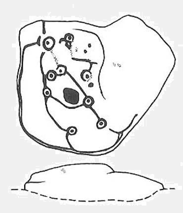
Unlike some folk who’ve seen this old stone, I find this carving superb. Its one of my favourites up here! Its alternative name – the Planet Stone – perhaps lends you to expect something more, but this is down to the astronomer who thought this was some type of heavenly image (which is most unlikely). I prefer to call it the ‘Map Stone’ because the correlates this carving has with indigenous aboriginal cup-and-rings is impressive and — to Aborigines anyway — would have all the hallmarks of a map. But not a ‘map’ in the traditional sense of modern humans. The incidence of cups and rings linked by curvaceous lines, typifies routes between water-holes or settlement spots made by ancestral beings — which is just what we find at this carving here. These ancestral beings need to be seen in a quite mythic sense: they may be creation deities (giants, gods, etc), animal spirits, the routes of shaman spirits, or other expressions of homo-religiosus.
Map Stone (note the carved line along the very edge of the rock)…and again from another angle
In the Map Stone here, we see that the very edge of the rock (fig.2 & 3) is ‘encircled’, perhaps (and I say perhaps) symbolic of the edge of the world. The lines and rings upon the top of the rock may symbolize journeys to and from important places. Another impression I get of this carving, with the “map” idea, is that the large pecked diamond-shaped ‘cup’ near the middle of the carving is a large body of water around which the archaic routeways passed. The next time anyone visits this stone, have a look at it with this idea in mind. Its simple, straightforward and makes sense (mind you – that doesn’t mean to say it’s right!).
The first account I’ve found of this comes from the pen of J. Romilly Allen (1882), where this stone “measuring 5ft 3in by 5ft, and 1ft 9in high” was described thus:
“On its upper surface, which is nearly horizontal, are carved thirteen cups, varying in diameter from 2 to 2½ in, eleven of which are surrounded by rings. There is also an elaborate arrangement of connecting grooves.”
Although we can only work our nine cup-and-rings here today, Mr Allen seemed suitably impressed with this old carving. Stan Beckensall (1999) seemed to have a good feel of this design too, describing it thus:
“Two thirds of the surface of this earthfast sandstone have been used in a design that partly encloses the marked part of the rock with long curvilinear grooves along its edge, and the inner grooves link single rings around cups. The effect is one of inter-connection and fluidity.”
Hedges 1986 sketch
The Map Stone was also looked at to examine the potential for Alexander Thom’s proposal of a megalithic inch: a unit of measure speculated to have been used in neolithic and Bronze Age times for the carving of cup-and-ring stones. Using nine other carvings on these moor as samples, Alan Davies (1983, 1988) explored this hypothesis and gave the idea his approval. However the selectivity of his data, not only in the carvings chosen, throws considerable doubt on the idea. Unfortunately the idea doesn’t hold water. The ‘geometry’ in the size of cup-and-rings relates more to the biometrics of the human hand and not early scientific geometry, sadly….
References:
Allen, J.R., ‘Prehistoric Rock Sculptures of Ilkley,’ in Journal British Arch. Assoc., 35, 1879.
Allen, J.R., ‘Notice of Sculptured Rocks near Ilkley, with some Remarks on Rocking Stones,’ in Journal British Arch. Assoc., 38, 1882.
Allen, J.R., ‘Cup and Ring Sculptures on Ilkley Moor,’ in Reliquary Illus. Archaeology, 2, 1896.
Beckensall, Stan, British Prehistoric Rock Art, Tempus: Stroud 1999.
Boughey, K.J.S. & Vickerman, E.A., Prehistoric Rock Art of the West Riding, WYAS: Exeter 2003.
Collyer, Robert & Turner, J.H., Ilkley: Ancient and Modern, William Walker: Otley 1885.
Cowling, E.T., Rombald’s Way, William Walker: Otley 1946.
Davis, Alan, ‘The Metrology of Cup & Ring Carvings near Ilkley in Yorkshire,’ Science Journal 25, 1983.
Davies, Alan, ‘The Metrology of Cup and Ring Carvings,’ in Ruggles, C., Records in Stone, Cambridge 1988.
Hedges, John, The Carved Rocks on Rombald’s Moor, WYMCC: Wakefield 1986.
Alan Davies’ image of the carving – with carved ‘lake’ near centre
Various ways to get here. I s’ppose the easiest is from Dacre village. If you go just past Sunny House, take the footpath on your right & walk along it, roughly straight across a number of fields, until you hit the footpath known as the Nidderdale Way. The field you’re now in should be scattered with numerous rocks all over the place (if it aint, you’re in the wrong place), reaching down towards the trees. Walk straight towards the trees for another 100 yards and the carving is somewhere hereabouts under your nose! You’re very close! If, however, you decide to walk up the Nidderdale Way from Dacre Banks, the field you need is the one immediately to your right just before you reach the Monk Ing Road trackway. The Tadpole Stone (or Eastwoods Rough II carving) is in the same field, close to the Nidderdale Way path — check that out aswell!
Archaeology & History
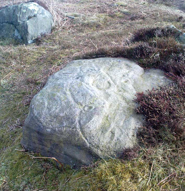
This is a large carving I found in April, 2006, in the company of rock-art student Richard Stroud (who sent us the pictures). Twas in the midst of a fine day wandering about checking some of the ‘known’ sites in the area, when we happened across two or three previously unknown sites — and as the day wore on, just before we were gonna head for home, this little beauty poked the edge of its head out of the turf! It had the pair of us in near rapture, with numerous “Wow’s” and excitable expletives coming from our mouths! We’re easily pleased us rock-art doods — but then it is a beauty when you first see it.
We came here several times in the weeks following its initial discovery, and it seemed that on each visit, we found an additional aspect to the carving. It seemed to keep changing each time we came here — hence the name ‘Morphing Stone’!
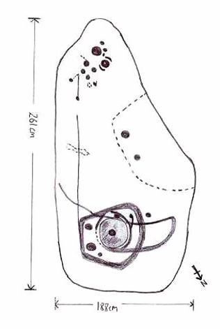
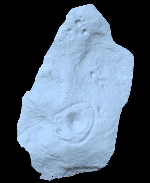
The prime feature in the carving is the very large oval-shaped ‘ring’ with huge carved bowl in the middle and several outlying cups-markings around it. Although it’s not plain to see in the photos, there’s a large tongue-shaped protuberance jutting out from one side of the main ringed feature. You can also see a small cluster of cup-marks on the top-right of the rock: from here — though it isn’t easy to see in the photo — a long straight line links up with the edge of the major central ring. Other lines run off on the top of the main feature and there are several other cup-markings on different parts of the stone. It’s obviously best to see the carving “in the flesh”, so to speak, to get a good impression of what it actually looks like. And, to those of you who might wanna venture up here, there are several others nearby.
A year or two after rediscovering the carving, rock art student Keith Boughey (2007) described the stone, saying:
“Measuring 2.61m from N-S and 1.88m from W-E at its greatest extent, the carved surface carries quite a complex design… At its N end is a large cup/basin with an approximate diameter of 25-30cm, surrounded by a ring that may or may not be complete: 2 cups have been incorporated into the ring on its N and W side. W of this ring a groove leads off S to a further possible cup. On the E side of the large central cup are 3 further cups of varying size. These motifs are all enclosed within a wide groove, which forms almost a dome pattern. Out of the ring, a further groove runs NW out of the design, bisecting the enclosing groove, curving round to form a handle shape before running back in towards the large central cup. The groove shows signs of continuing E towards the edge of the stone. Just outside the W edge of the enclosing dome is one well-defined cup. S of this, in a slight depression, are 2 further cups of differing size. A straight groove appears to run SW out of the enclosing dome shape on its E side towards further motifs on the stone’s S side. The groove may run into an area of cup marks, but there appears to be a break before it continues. When exposed, the carvings looked quite fresh and sharp, suggesting that they had remained covered for some considerable time – possible since antiquity or at least from a time in the prehistoric past when cup-and-ring-markings had begun to lose their significance and were no longer required to be visible in the landscape.”
To those of you who like the new computer images of cup-and-rings, the three below are samples from a number of such images done after the stone had been discovered. Intriguingly, the long line running between the cluster of cups to the large cup-and-ring doesn’t show up too well; but the barely perceptible line running out, zigzag-fashion, from the large central cup-and-ring, shows up much clearer than when looking with the naked eye.
Although cited as being on Weston Moor, it is closer to Askwith village. From the village, take the north road and shortly before reaching the T-junction, park-up (somewhere!). There’s a small copse of trees on your right and fields above them – that’s where you’re heading. You might have to bimble about a bit before the rock catches your attention, but it’s worth the wandering. Look around!
Archaeology & History
Sketch of the design c.1985
This is an excellent, archetypal cup-and-ring stone that’ll be loved by any real rock art student! Cups-and-multiple rings are the main visual feature to this stone, along with another 20 single cups and another primary cup-and-ring, all on a medium-sized sloping rock face. The carving was first described by Cowling & Hartley (1937). Since their initial discovery, several other writers have mentioned it with little further comment. The smaller but impressive double cup-and-ring carving 543 can be seen at the bottom left of the woodland in front of you – well worth seeing if you’re visiting here!
References:
Boughey, Keith & Vickerman, E.A., Prehistoric Rock Art of the West Riding, West Yorkshire Archaeology Service 2003.
Cowling, Eric T., Rombald’s Way, William Walker: Otley 1946.
Cowling, E.T. & Hartley, ‘Cup-and-Ring Markings to the North of Otley,’ in Yorkshire Archaeological Journal, 33, 1937.
Hotham, John Paul, Halos and Horizons, Hotham Publishing: Leeds 2021.
Follow the same directions for the Ellers Wood 614 and 618 carvings, as it’s nearby. The best way to check them out is simply to walk down past the haunted Dobpark Lodge, where it turns into a footpath and then when you reach the lovely old packhorse bridge at the valley bottom, walk upstream for 3-400 yards until you reach the next small wooded region. Once there, look around…..
Archaeology & History
Ellers Wood is at the very northern edge of the beautiful parish of Askwith and has a very particular ambience of its own. The small cluster of at least 5 cup-and-ring stones in this lovely little woodland gives you the impression that they stood out on their own, living here respresenting the genius loci of this luscious watery vale, all-but-hidden from all but the lucky few.
Cowling’s 1937 sketch1991 sketch of CR-619
Beautifully preserved, this carving was first described in an article by Cowling & Hartley (1937), then included in Cowling’s Rombald’s Way (1946). As with the other cup-and-rings close by, the characteristic grouping of certain cups is here focused into three sections by enclosing rings. This was something I used to call ‘central design’ features, which occur in different locales with their own individual geographical patterns/structures. These central designs are non-numeric in nature, though have a tendency to cluster in patterns of 2, 3 and 4. (I need to write a decent essay on this to outline what I’m on about with greater clarity!)
References:
Boughey, K.J.S. & Vickerman, E.A., Prehistoric Rock Art of the West Riding, WYAS: Exeter 2003.
Cowling, E.T., ‘A Classification of West Yorkshire Cup and Ring Stones,’ in Yorks. Arch. Journal 1940.
Cowling, Eric T., Rombald’s Way, William Walker: Otley 1946.
Cowling, E.T. & Hartley, C.A., ‘Cup and Ring Markings to the North of Otley,’ in Yorks. Arch. Journal 33, 1937.
Grainge, William, The History and Topography of the Forest of Knareborough, J.R. Smith: London 1871.
Grainge, William, History and Topography of the Townships of Little Timble, Great Timble and the Hamlet of Snowden, William Walker: Otley 1895.


")
")


 Allen 1879")


")
