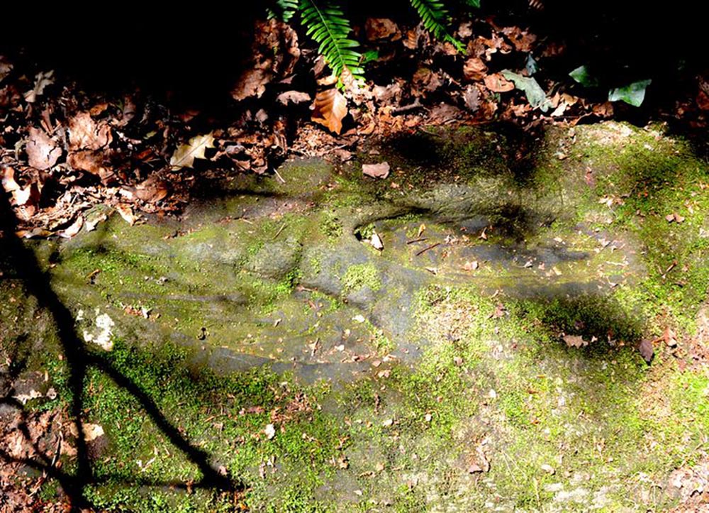
St Columbkille’s place in Irish history was considerable and, said Maghtochair (1867), he was said to have “founded more than one hundred churches and religious houses.” His feet, also, have been carved or burned into a number of rocks scattering the Irish landscape. Not to be confused with his ‘feet’ that are carved near Londonderry, the ones here have been classed in the archaeological inventories as a bullaun and, wrote Brian Lacy (1983) in the Donegal Archaeological Survey, can be found on,
“A 2m long ledge of rock outcrop containing two depressions, c.0.33m in diameter x ).1m deep. They are known locally as St. Columbkille’s footprints.”
As can be seen in the above photo, the ‘footprints’ seem to have been artificially outlined at some time long ago, to make them more notable.
References:
Lacy, Brian, Archaeological Survey of County Donegal, Donegal County Council 1983. p.307
Maghtochair, Inishowen – Its History, Traditions and Antiquity, Journal Office: Londonderry 1867.
Sconce, James, “Cup-Marked Stones,” in Transactions of the Edinburgh Field Naturalists, volume 5, 1907.
Swan, Harry Percival, The Book of Inishowen, William Doherty: Buncrana 1938.
Acknowledgements: Big thanks to Catherine, of the We Love Donegal website.
Holy Well (destroyed): OS Grid Reference – SE 2894 3382
Archaeology & History
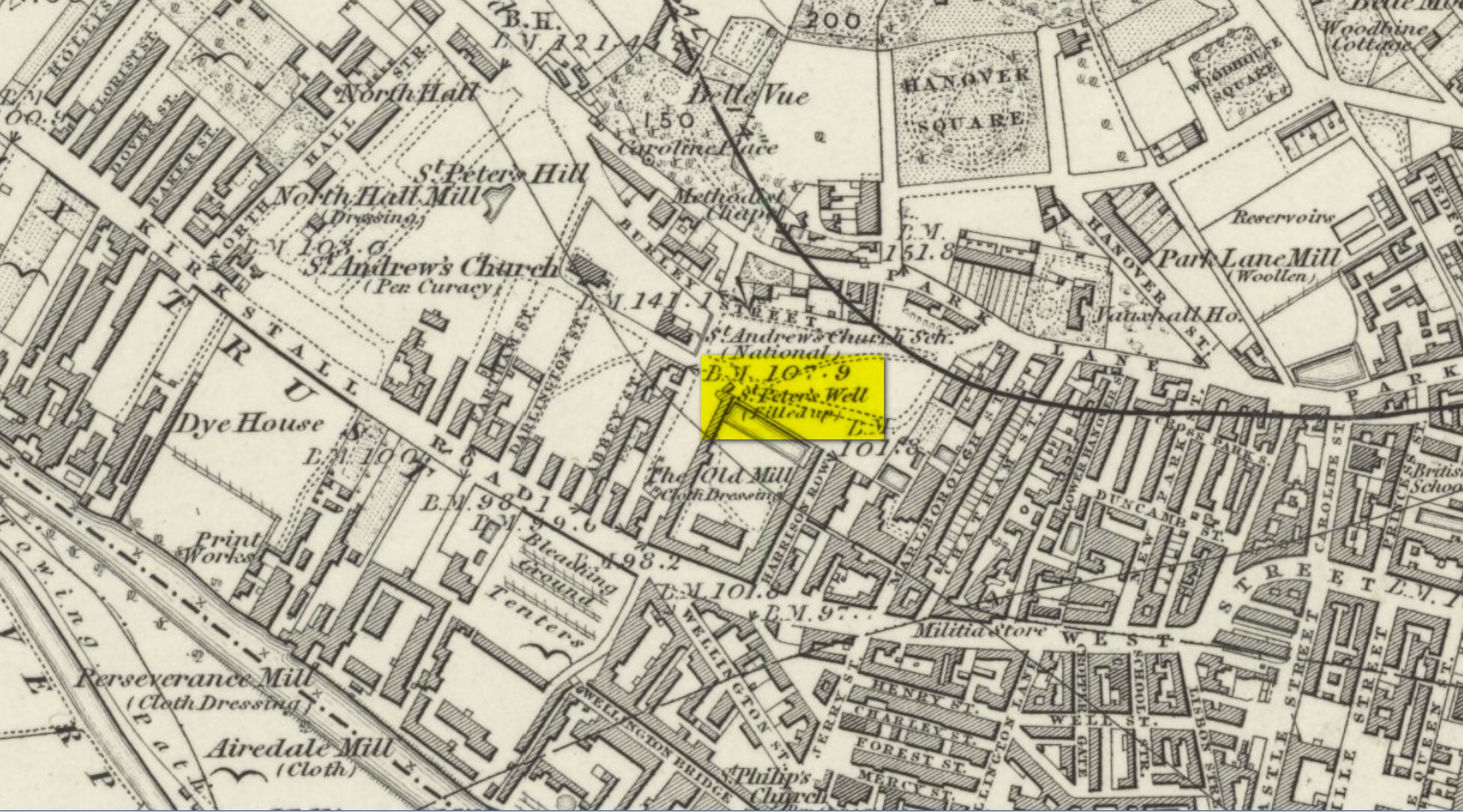
St Peters Well on 1852 map
Not to be confused with the other St. Peter’s Well that once existed in the city centre, this site was shown on an 1815 map of Leeds (which I’ve not been able to get mi hands on!), known as the Waterloo Map. But when the Ordnance Survey lads visited the place in 1846, it had been covered over. Immediately west of here, the saint’s name was also given to a nearby hill, whose folklore seems has been forgotten.
Although Ralph Thoresby mentioned it in passing, Edward Parsons (1834) gave us a brief description of its qualities, telling us that,
“Near North Hall is the celebrated spring called St. Peter’s Well ; the waters are so intensely cold that they have long been considered very efficacious in rheumatic disorders.”
Bonser (1979) reiterated this in his survey, also telling that, like its nearby namesake, its waters were “intensely cold and beneficial for rheumatism, rickets, etc.” An old bathing-house that was “annexed to the Well” may have been used specifically to treat such ailments, but we cannot say for sure.
Interestingly, Andrea Smith (1982) told that 400 metres away a well was sunk in 1838 and a quantity of petrified hazelnuts were recovered from a broken red jar which had a female head painted on it. Such a deposit is not too unusual, as a number of sacred wells in bygone days were blessed with nuts and signified the deity Callirius, known by the Romans as Silvanus, the God of the Hazel Wood – though we have no direct tradition here linking St. Peter’s Well with this ritual deposit.
St. Peter’s festival date was June 29.
References:
Bonser, K.J., “Spas, Wells and Springs of Leeds,” in The Thoresby Miscellany – volume 54, Leeds 1979.
Hope, Robert Charles, Legendary Lore of the Holy Wells of England, Elliott Stock: London 1893.
Parsons, Edward, The Civil, Ecclesiastical, Literary, Commercial and Miscellaneous History of Leeds, Halifax, Huddersfield, Bradford, Wakefield, Dewsbury, Otley – volume 1, Frederick Hobson: Leeds 1834.
Smith, Andrea, ‘Holy Wells Around Leeds, Bradford & Pontefract,’ in Wakefield Historical Journal 9, 1982.
Holy Well (destroyed): OS Grid Reference – TL 10302 30328
Also Known as:
Hertfordshire Historic Environment Record No. 1926
Archaeology & History
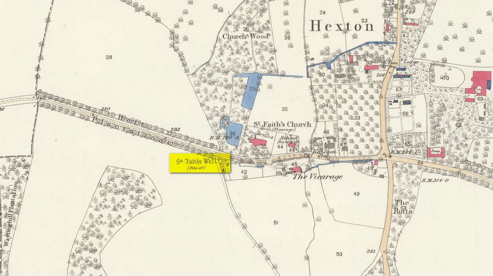
The site of the well is now in the garden of a house on the south side of the B655 Barton Road in Hexton, south west of St Faith’s church. Prior to the Reformation, there was a small chapel of St Faith adjacent to the well containing a shrine to the saint, which was, with the well a place of pilgrimage.
N. Salmon, writing in 1728, told us:
St Faiths Well on 1882 map
“At Ravensborough, within a Quarter of a Mile, is a fine Spring, which runs down to Hexton, and meets there another Stream rising at the Berystede near the church, which is indeed a very remarkable one. It comes pouring out of the Earth in such plenty, that it would turn a Mill in a very little Way; and hath been since the Roman Times thought worthy of a Saint’s Name. It was called St Faith’s Well, to which the church also is dedicated, and the Image of St Faith was placed over it.”
The well is just to the north of the iron age hill fort of Ravensburgh and near the ancient prehistoric roadway of Icknield Way, so would certainly have been a welcome stopping point for prehistoric travellers in these chalk uplands. In line with Salmon’s contention of its having been known since Roman times, Francis Taverner, the 17th century Lord of the Manor of Hexton wrote of the well having been used for oracular purposes by people who would throw an object onto the surface of the water:
“which if swamme above they were accepted and there petition granted, but if it sinke, then rejected which the experienced Prieste had arts enove to cause to swymme or sinke according as himselfe was pleased with the partye, or rather with the offering made by the partye.”
St Faith who was a third century martyr who was beheaded at Agen in Gaul. Her saint’s day is 6th October, and her patronage was invoked inter alia by pilgrims, so the dedication of the well and nearby church may have been to ‘christianise’ a pre-existing oracular place resorted to by travellers on the Icknield Way.
Taverner again:
“There is a small parcel of ground adjoining the churchyard called “St. Ffaith’s Wick Court,” about a pole in measurement, anciently divided from Malewick by a ditch in the same place where now a large moat is made. The greatest parte of this Wick lying upon a bedde of springs, and undrained, was very boggye towards the churchyard; but the west side being higher, the ground was well planted with oaks, willows, and bushes, near adjoyning unto which, the craftye Priests had made a well about a yard deepe, and very cleere in the bottome, and curbed about, which they called St. Faith’s Well.
“Now over this well they built an howse, and in the howse they placed the image or statue of St. Faith, and a cawsey they had mad (which I found when I digged and levelled the ground) for the people to passe who resorted thither from farr and neere to visitt our Lady, and to performe their devotions reverently, kissing a fine-colloured stone placed in her toe. This Lady was trimly apparelled, and I find in an old book of churchwarden’s accounts, in the reign of Henry VIII, that they had delivered unto the St. Ffaith a cote and a velvet tippet. The Lady had no land to maintain her, that I know of, more than i acre lying in Mill Field, called at this day St. Ffaith’s acre, which, as being given to superstitious uses, came to the King’s hands at the dissolution, and is now parcel of the demesnes. The house being pulled down, and the idol cast away, the well was filled up, yet an apparent mention of the place remained till my time, and St. Ffaith’s Well continued as a waste and unprofitable and neglected piece of land till such time as the footpath was turned through the midst of it to the outside on the south by the highway, and their clearing and levelling the ground, having been drained, and sunk the spring, I converted the same, in the year of our Lord 1624, into a little orchard. The Lady Ffaith was a Virgin and Martyr of Agenne, in France, a.d. 1290.”
The well may have had healing properties too. Herbert Tompkins (1902) informed us how,
“…to folk who have never stepped out of Hertfordshire (I have known several such) the well of St. Faith is indeed the “Well at the World’s End.” The waters of that well were of miraculous efficacy, and an image of its saint was long preserved in the chapel of St. Faith Virgin, of which no stone remains.”
The parish church of Hexton remains dedicated to St Faith , as does the parish church of nearby Kelshall. There was another St Faith’s Well at Leven in East Yorkshire.
References:
Clutterbuck, Robert, History & Antiquities of the County of Hertford – volume 3, Nichols Son & Bentley: London 1827.
Farmer, David Hugh, Oxford Dictionary of Saints, Oxford University Press 1987.
Hippisley-cox, R., The Green Roads of England, 6th Edition, Methuen: London 1948.
Hope, Robert c., Legendary Lore of the Holy Wells of England, Elliot Stock: London 1893.
Johnson, Walter, Folk Memory or the Continuity of British Archaeology, Clarendon Press: Oxford 1908.
Jones-Baker, Doris, Old Hertfordshire Calendar, Phillimore: Chichester 1974.
Salmon, N., History of Hertfordshire, London, 1728.
Tompkins, Herbert W., Highways & Byways of Hertfordshire, Macmillan: London 1902.
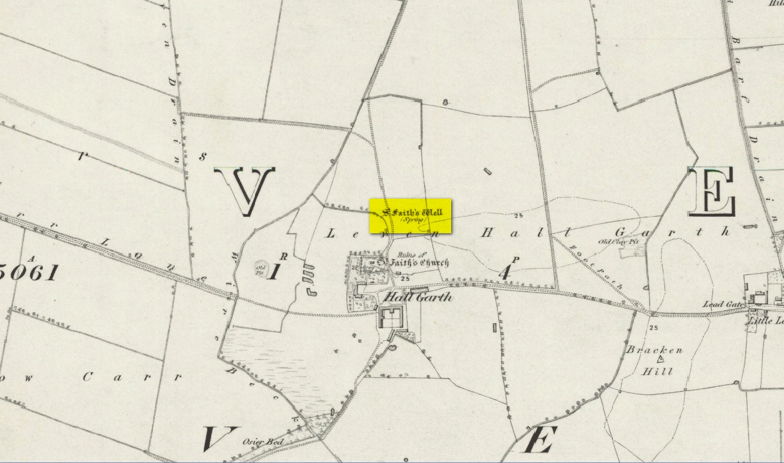
The site of the well is on the Carrs to the west of Leven village, immediately north of the old cemetery adjoining Hall Garth house. Reverend William Smith, writing in 1923, told us:
St Faiths Well on 1855 map
“St Faith’s Well lay on the left of the road known as St Faith’s Lane, which leads to the old churchyard to which the spring was near. St Faith belonged to France, and when quite a young maiden, was martyred because of her christianity. She lived and died in the third century….
“St Faith’s Well was filled in about a hundred years ago and the site lost. This, however, has lately been approximately fixed by the aid of water divining. A Leven man, who can wield the hazel wand, went over the ground near to which the well was thought to have been, and the wand indicated a spot under which, on digging to the depth of about three feet, “the water fairly bubbled up”, and it was judged this was the place where the well lay. St Faith’s Well is said to have given water both pure and abundant, and to have been in the old days the only supply of drinking water to the people of the Carrs.”
St Faith’s Saint’s day is the 6th October and she was a saint whose patronage was invoked by pilgrims, prisoners and soldiers. From this, is it perhaps reasonable to infer that St Faith’s Well may have been a station for pilgrims to the local shrines of St John of Beverley and St Philip Ingleberd at Keyingham? Also a stopping point for fugitives seeking sanctuary at Beverley?
There was another holy well dedicated to St Faith at Hexton in north Hertfordshire.
References:
Cox, J.Charles, The Sanctuaries & Sanctuary Seekers of Mediæval England, George Allen: London 1911.
Farmer, David H., Oxford Dictionary of Saints, Oxford University Press: Oxford 1987.
Smith, Rev. William, Ancient Springs & Streams of the East Riding of Yorkshire, A. Brown: Hull 1923.
Holy Well (destroyed): OS Grid Reference – NT 0976 8666
Archaeology & History
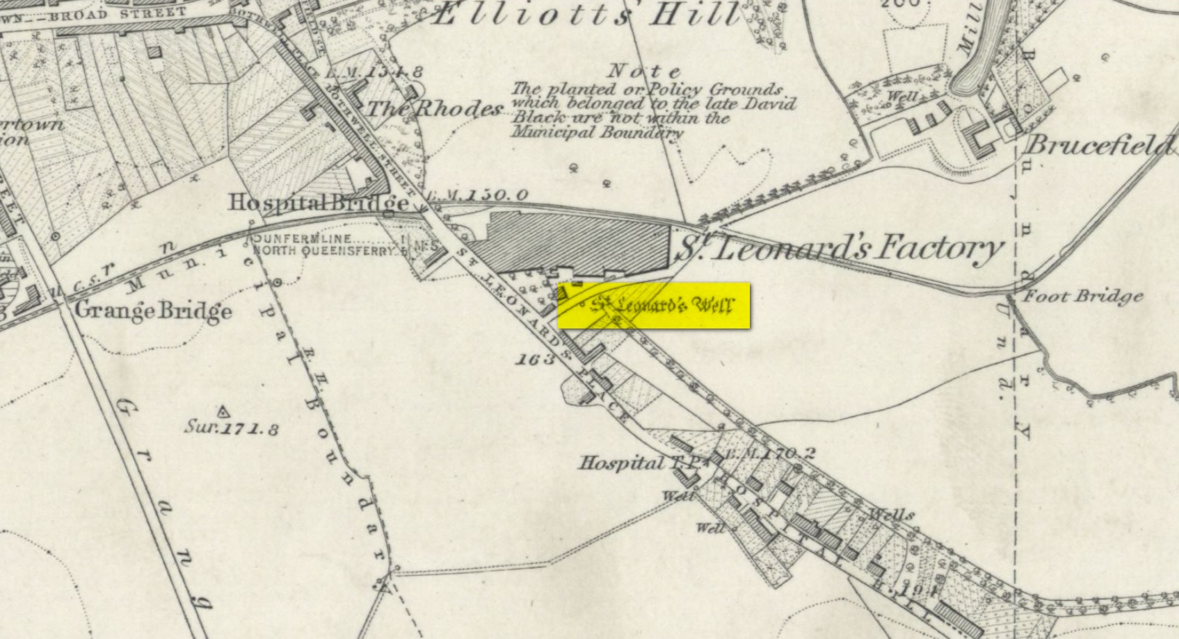
Site shown on 1856 map
There seems to be very little information available about this holy well, lost long ago and now hidden beneath the foundations of a food superstore! It was found in close association with both a chapel and a hospital in St. Leonard’s name—both of which have also been destroyed. The water from here may have been used by the monks for patients in the hospital, but that’s purely speculative. St. Leonard was known to be connected with lepers, which may be something that the waters here were used to treat. But again, I’m speculating…
When the Ordnance Survey lads came here in 1853, the waters were still running and they subsequently added it to their map a few years later. The site was still visible when Erskine Beveridge (1917) came here, telling us briefly that,
“St. Leonard’s Well still remains a little to the south-east, and, though now built up, is recognisable.”
But a few years later it had been destroyed and its position was shown on the updated OS-map of 1926 as “Site of.” The old well had gone…
Simpkins, John Ewart, Examples of Printed Folk-lore Concerning Fife, with some Notes on Clackmannan and Kinross-shires, Sidgwick & Jackson: London 1914.
Walker, J. Russel, “‘Holy Wells’ in Scotland,” in Proceedings of the Society of Antiquaries of Scotland, vol.17 (New Series, volume 5), 1883.
Acknowledgements: Big thanks for use of the 1st edition OS-map in this site profile, Reproduced with the kind permission of the National Library of Scotland.
In 1897, when Butler wrote his history of the village, he told that a certain well, “adjacent to the Gattaway stream” (thought to be the Nethy Burn which passes Gattaway farm) was known to old locals as Brendan’s Well, with the name still surviving as ‘Bredni Well’. There were a number of large boulders around it that had been scattered by blasting, but which Butler thought were, “in all probability placed originally near the wall as a guide for pilgrims.”
The site was included in Ruth & Frank Morris’ (1982) survey, adding simply that the site was named “after the saint who lived here in the seventh century.” In the christian calendar, St. Brendan’s day was May 16.
When the local antiquarian Paul Hornby looked for the well, a local lady told him that she thought an occasional but regular boggy patch that appeared in her garden was due to the underground waters from St Brendan’s Well.
References:
Butler, D., The Ancient Church and Parish of Abernethy, Edinburgh 1897. Page(s): 102
An old church dedicated to St Bennet once existed on the hill above where this spring of water emerges, but little is now left of the building. Thankfully the holy well hasn’t quite followed in the footsteps of the church. Miss Riley (1935) told us that it can be found “near the high-water mark…situated at the foot of a beautiful little glen which runs inland from the coast” – and from all accounts it is still there.
Shown on the 1880 OS-map of the region, the dedication to St Bennet is obscure. Mr Pullan (1927) suggested it derived from the 6th century St Benedict of Nursia, but this is improbable. The Royal Commission lads thought it more likely derived from “a Celtic foundation.”
Folklore
The earliest description I’ve found regarding the traditions surrounding this well are by Hugh Miller (1835). He wrote:
“It is not yet twenty years since a thorn-bush, which formed a little canopy over the spring of St. Bennet, used to be covered anew every season with little pieces of rag, left on it as offerings to the saint, by sick people who came to drink of the water.”
But the tradition didn’t die out, as evidenced by a short article by Miss M.D. Riley (1935) in Antiquity journal where she gave us further valuable information about its folk history, saying:
“In order to insure the fulfilment of the wish it is essential that the wisher should drink the water and leave something of his personal attire. When the writer visited the spot there was a heterogeneous collection of ‘rags’ hanging on the branches.
“Mr Francis Scott tells me that the site is locally supposed to be the place of judgement. It is close to the ruins of St Bennet’s Chapel and the ground is said to be cursed as it was stoeln by the Church. Even at the present day the owner has to provide each year at Christmas-tide 8 cwt of oatmeal free for the poor of the parish. This has been operative since 1630 and though the owner has tested the matter in the highest court of law in Scotland, his appeal was not allowed.”
The tradition of giving offerings to the spirit of this well was still recorded in 1966.
References:
Hiley, M.D., “Rag-Wells,” in Antiquity, volume 9:4, December 1935.
Were it not for the valuable records in the Scottish Statistical Accounts, we’d have lost all knowledge of this site. It was described in notes by by Colin Baxter (1793), where he told us:
“About 200 yards west from the church of Monivaird, a barrow was opened some years ago, in which two urns were found, each containing a stone of a bluish colour, very hard about four inches long, and of a triangular shape, somewhat resembling the head of an axe.”
The site was subsequently mentioned in the Ordnance Survey Name Book of the parish, with some additional bits of information:
“In the year 17–, there was found, about one hundred yards to the westward of the old church of Monzievaird, a barrow containing a stone-coffin, in which were inclosed two coarse earthen urns, the one filled with burnt bones, the other containing the bones of the head. Of these, the under jawbone and the teeth were very entire. In the stone coffin was also found a stone hatchet, bluish-coloured, very hard, about four inches long, and of a triangular shape, a remain which proves the barrow of very remote antiquity – prior to the use of iron. The stone hatchet is preserved at Ochtertyre.”
No traces remain of the site; and although the stone axes came to be in the possession of Sir William Murray of Ochtertyre, the urns and other remains have long since been lost.
Folklore
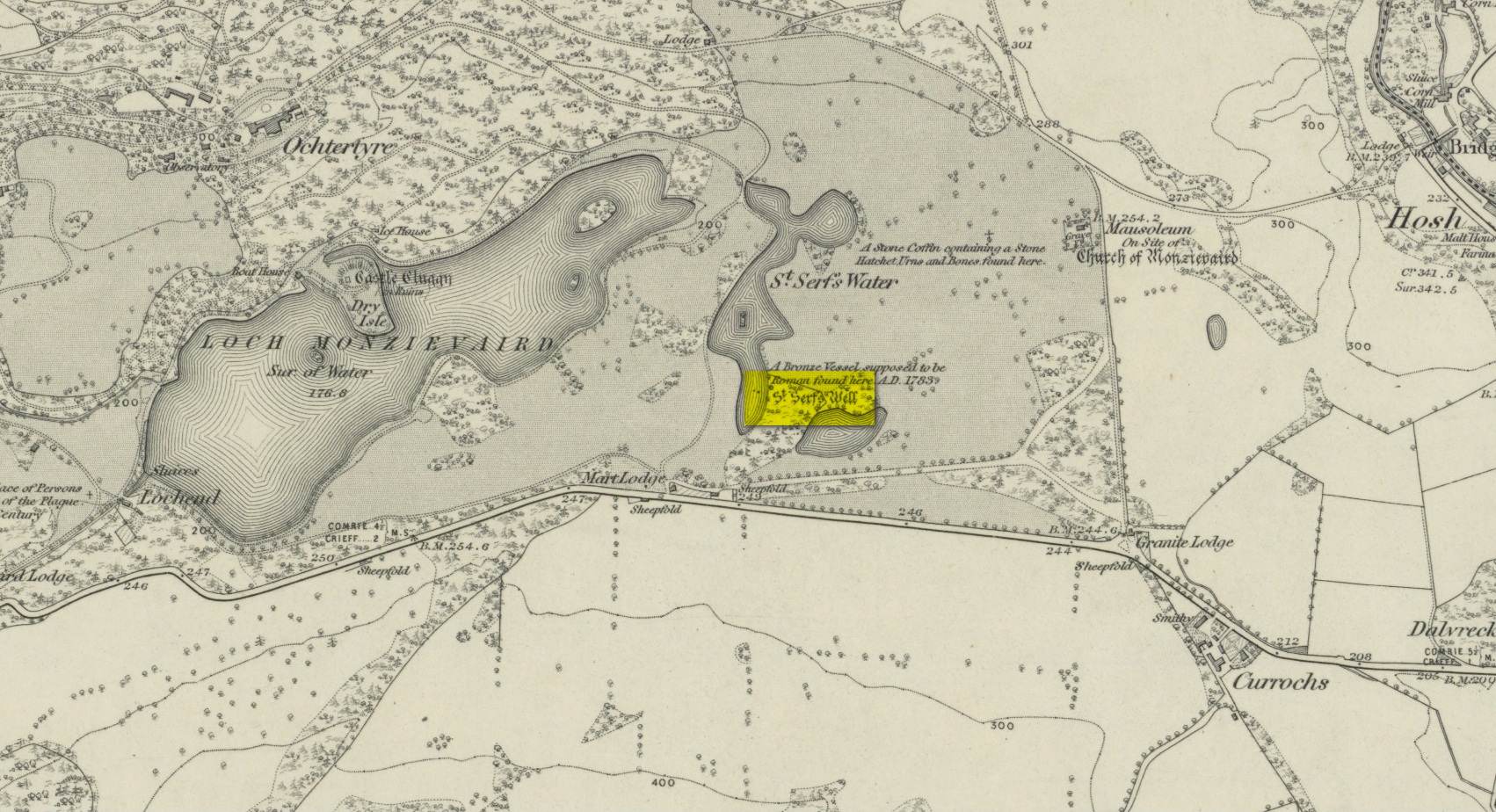
The name of ‘St Serf’s Water’ derives from it this area being dedicated to St Servanus in early times; the holy well of St Serf could be found a short distance south from where this tomb was built.
References:
Baxter, Colin, “United Parishes of Monivaird and Strowan,” in Statistical Account of Scotland – volume 8, William Creech: Edinburgh 1793.
Holy Well (lost): OS Grid Reference – NN 8457 2323
Archaeology & History
St Serfs Well on 1866 map
A mile to the west side of Crieff, in the grounds of the 18th century mansion known as Ochtertyre House, could once be seen the little-known sacred well of St Serf. Sadly its waters seem to have disappeared beneath the rising waters of the loch known as St Serf’s Waters—which is a pity, as the place was of importance in the annual traditions of the local people, who left offerings to the spirit of the place, as was common in days of olde. It was described in Mr Porteous’ (1822) account of Monzievaird parish, in which he told that,
“Nigh to this place is St Serf’s Well, and the moor whereon St Serf’s market is held. He was the tutelary saint of the parish of Monivaird. This well is a plentiful spring of water. About sixty years ago, our people were wont, on Lammas day, to go and drink it, leaving white stones, spoons, or rags, which they brought with them; but nothing except the white stones now appear, this superstitious practice being quite in oblivion. It has been useful in a strangury, as any other very cold water would be; for a patient, taking a tub full of it immediately from the well, plunging his arms into it, which were bare to the elbows, was cured.
“St Serf’s fair is still kept on the 11th of July, where Highland horses, linen cloth, etc., both from the south and north, are sold.”
Although the well is deemed to be ‘lost’, it is possible that its waters might be seen after a good drought. Please let us know if that happens.
Folklore
St. Serf was said to have been a hermit and tutor of the more renowned St. Mungo.
Acknowledgements: Big thanks for use of the 1st edition OS-map in this site profile, Reproduced with the kind permission of the National Library of Scotland.
An entry in George Benson’s huge work on the history (mainly) of York, describes the holy well of St Dunstan “near the Glass Works”, which used to be at the south-side of the city on Fishergate. I can find no other reference to this site and it’s not on the early OS-maps, so we must presume it is long gone.
Other wells in his name can be found in Kent, Somerset, Sussex and Tottenham.
Folklore
The fable relating Dunstan to wells was his ability to make springs miraculously appear. Tradition relates him to have been born in Wessex in the 10th century. His festival date is May 19.
References:
Benson, George, An Account of the City and County of York – volume 3, Cooper & Swans: Micklegate 1925.