Healing Well (destroyed): OS Grid Reference – SE 0479 4179
Archaeology & History
The Whin Knoll Well, once found bursting into life at the top of Black Hill, Keighley, got its name from the old word ‘whin,’ or gorse bushes (Ulex Europaeus)—also known in Yorkshire as the ‘Spindly Killer Bush’: a most apt title! These great spindly killer shrubs once profused where the waters of this old well used to bubble into view – indeed, there are still quite a few great old spindlies still scattered here and there!
The site was shown on old maps as being just two fields east of the more renowned Jennet’s Well, but this old public water supply that once fed the local people, was covered by a reservoir many moons ago. However, a wander up here recently found the reservoir empty, but a water supply was still bubbling out of the ground into the great concrete hollow. The last remnants of the Whin Knoll Well perhaps…?
Dead easy! Get to Ilkley train station and look across the road to your left, cross it and walk along. 100 yards on is Cowpasture Road. Walk up it! You’ll be at the rocks in 10-15 minutes.
Archaeology & History
Cow & Calf Rocks from above – thanks to Ian Hay’s superb ‘Yorkshire from the Air’
There’s nowt specifically archaeocentric directly relating to these great rocks — well, nowt that’s been found out about anyway! — though all around here over the last coupla centuries people have found numerous flints, and we have various examples of rock-art (cup-and-rings) carved on rocks close by. There have been attempts to verify what may be cup-marks on both the Cow and the Calf — with the old master, Harry Speight (1900) telling how there used to be remains of cups and lines on the rocks, but apart from some well-worn ‘cups’ on some of the edges, these seem hard to find. For worrits worth: if Speight said there were some carvings here, its more than likely true.
I think the main relationship ancient man would have had with this great rock outcrop would have been a ritual one: the rocks themselves had no need of human imprints: their size and nature would deem them of great spirit indeed, to anyone with an ounce of feeling. Not sure that’s the way most modern folk would see things – but that’s to be expected I s’ppose!
Folklore
These grand rocks once had the even greater Bull Rock as a close companion. It was on top of this, wrote Eric Lodge (1939:40), that,
“the only point in the immediate vicinity of Ilkley from which a view of York Minster was obtainable. ‘Tis some sixty years ago, however, that a local tradesman recognised its value in building stone, and despite strong protests, quarried it for the construction of the Crescent Hotel, situated at the corner of Brook Street and Leeds Road in Ilkley.”
The matter was described in the Leeds Mercury in 1899, thus:
“About the year 1850 an act of vandalism was perpetrated at Ilkley, which would have been impossible in these days, when the Ilkley Local Board watches with such a keen eye anything that may enhance the historical interest of this rapidly increasing watering-place.
“Below the two huge rocks known as ‘The Cow and Calf,’ which have attracted thousands of visitors and invalids on to the breezy heights whereon they stand, stood a rock larger than the Calf, which was known as the ‘Bull.’ It was much nearer the highway than the Calf…
“The ‘Bull’ rock had its name cut in large letters on the side that lay nearest the road, and it is much to be regretted that an unfortunate dispute between the owners of the free-hold and the lord of the manor, in which the former won the day, gave them the right to break up this noble rock and cart it away for building purposes. It is said that the Crescent Hotel was mainly built from this stone, so some idea may be formed of its vast size and proportions.”
Incredible – they’ve turned a gigantic sacred rock into a large hotel! (and I’ve never been in it) Let’s hope it’s haunted to buggery! Does anyone know any Fortean history about the place?
Another legend tells that one day the local giant, Rombald (who gave his name to these moors and lived up here, somewhere, with his even greater but unnamed wife), decided to meet a friend a few miles away to the east, at Almscliffe Crags. So in just one step he strode over the Wharfe valley right across to the legendary crags, but he slightly stumbled and in doing so, left he footprint embedded on the face of the Cow Rock, which can still be seen today.
In modern times, the Cow & Calf have been the centre for occasional UFO, or earthlight sightings. But this appears to go back a bit earlier than when such curious light-forms were thought of as visiting ETs; for good old Nicholas Size (1936) reported seeing burning lights and curious figures up here — but when he saw these lights they took the form of druids and pagan spirits. One wonders what they’ll morph into next!
Not too hard to find really. On the far western edge of the King’s Park golf course, head for the highest point where the small cliffs drop down. From here, walk down the footpath on the slight slope south, just below where the small copse of trees are, and you’ll see the singular small flat stone in the grasses near the footpath you’re walking along. If you can’t find it – look around!
Archaeology & History
A little-known but fascinating isolated carving, first described by David Morris at the sixth meeting of the Stirling Natural History and Archaeological Society in 1901. It is found on the western edge of the town, above the rocky edges not far from the pond of St. Thomas’ Well on the far edge of the golf course. Morris’ finding was written up in their fine journal, where he wrote:
“In the King’s Park, about 50 yards east of the cliff where a seat overlooks the Douglas Terrace sand quarry, there is a smooth surface of rock showing through the turf, measuring two-and-half feet by one-and-half feet… On it is a cup-shaped hollow, outside the rim of which is a well-marked hollowed ring, beyond which is another faintly marked, concentric circular groove. The cup-mark measures one-and-a-half inches across; the inner rim of the first circle is 4 inches, and the outer rim is 6 inches in diameter. The outer circle, if complete, would be 9 inches in diameter. The depth of the central hollow is half-an-inch, and of the inner groove fully one-quarter of an inch. The markings are plainly artificial…”
King’s Park CR – central design, pointing to northernmost cup
In good sunlight, it is obvious that the carving is a fine example of a double-ringed cup-and-ring carving – though the outer ring may not be complete. The Scottish Royal Commission lads told that “this rock outcrop bears three cup marks” – one of which has the rings surrounding it. In the first photo here, the southernmost cup-marking is highlighted in the centre of the two shells which were on the rock when we arrived.
However, there’s definitely more to this carving than previous investigations have outlined. It seems that the northernmost cup-mark has a ring and a possible outer-ring. There is also a distinctive linear carving, which at first seems like a primitive triangle, just below the southernmost cup – as we’ve tried illustrating here in the photo which Mikki Potts took. It’s faint, but once you see it, it’s obvious that it’s there. Other faint lines of similar nature also seem apparent near the northernmost cup-marking, but we will have to wait for rubbings and further visits in better light to ascertain the full image on this rock. Well worth checking out if you like your rock art! (can any of you Scottish rock-art fanatics have a closer look at this? – take a rubbing of it and see what other aspects are on this design)
Faint linear carvings on southern end of the rock
One other thing which seemed apparent when we were here: this site has all the geomantic hallmarks of accompanying a burial at some time in the ancient past. Its isolation here is unusual and the carving is only 50 yards from the highest point hereabouts, where you have 360-degree views all round, typifying the position of many prehistoric tombs.* Does anyone know about such features, or have records of any field-name surveys taken, which might confirm or deny this thought? Twouldst be good to know!
References:
Feachem, Richard, Prehistoric Scotland, Batsford: London 1963.
Morris, David B., “Cup and Ring Marked Rock Surface in King’s Park,” in Stirling Natural History & Archaeology Society Transactions, 1900-1901.
Morris, Ronald W.B., The Prehistoric Rock Art of Southern Scotland, BAR 86, Oxford 1981.
Royal Commission on the Ancient and Historical Monuments of Scotland, Stirlingshire – 2 volumes, HMSO: Edinburgh 1963.
Royal Commission on the Ancient & Historical Monuments of Scotland, Archaeological Sites and Monuments of Stirling District, Central Region, Society of Antiquaries of Scotland 1979.
* Since writing the above, thanks the correspondence of Paddybhoy, we’ve learned that there definitely were prehistoric tombs close by; one being just at the bottom of the ridge below the carving, on Douglas Terrace. Records describe several other prehistoric tombs nearby at Birkhill House, the Birkhill Sandpit and Coneypark Nursery. However, I still think it most probable that there were other tombs and more rock art, probably along the edges of King Park, aswell as the Cambusbarron plain. These need locating.
Cup-and-Ring Stone (lost): OS Grid Reference – SE 142 396
Archaeology & History
Listed in Boughey & Vickerman’s (2003) survey as ‘stone 186,’ I first came across a reference to this carving when I was young, in a short article by Sidney Jackson (1964) in his Cartwright Hall archaeology journal. A letter was sent to Mr Jackson in 1963 by a Mr Bernard Stubbs of Baildon, who wrote:
“This morning I visited Hope Farm, Baildon, where Mr Jim Bell, the farmer, told me of a cup-and-ring boulder which he had discovered while digging a hole to bury a sheep, in the polt of land at the rear of the farmhouse… He stated that the hole was covered with cup-and-ring markings. Unfortunately, the hole has been filled and concreted over.”
And no one has seen it since then! Damn! Recently we discovered a cup-marked stone carved on a now-upright stone in old walling in one of the fields immediately west of the farm, but it’s obviously a different one from that described in Mr Stubbs’ letter. There are several other carvings in this region that are not in the official records, but this particular ‘lost’ stone remains lost for the time being!
References:
Boughey, Keith & Vickerman, E.A., Prehistoric Rock Art of the West Riding, WYAS: Wakefield 2003.
Jackson, Sidney, ‘New Cup-and-Ring Boulder,’ in Cartwright Hall Archaeology Group Bulletin, 9:1, 1964.
Cup-and-Ring Stone (destroyed?): OS Grid Reference – SE 129 379
Archaeology & History
Over the years, many of us have looked for this site but without any success. If it hasn’t actually been destroyed, it could be in someone’s garden wall, probably without them even knowing about it. Indeed, even the grid reference given here is only an approximation (mine differs from the one cited by Boughey & Vickerman, who put the carving closer to SE 126 381) and the stone could have been a few hundred yards either side of here. The main description of it comes from a letter written by a Mr T.P. Noble in 1964, which was cited in Sidney Jackson’s article ‘Hirst Wood Cup-and-Ring Boulder,’ in Bradford’s Cartwright Hall archaeology journal, where Mr Noble wrote:
“Mr Cooper, who built these houses (Hirst Wood housing estate) about 1935, once told me that there was a perfect example of a cup-and-ring stone here, but later, when he came to search for it, he couldn’t find it. It appears it must have been removed and possibly broken-up when the foundations of the houses were excavated.”
Of course, as we don’t know the exact whereabouts of the carving, nor have we been left with an illustration of the stone, it’s difficult to say whether the description given by the great archaeologist Sir Mortimer Wheeler in 1958, is referring to the same carving. Wheeler told us that one day in his childhood when he was out walking with his father, R.M. Wheeler, they came across a seemingly unknown prehistoric carving, saying,
“On one memorable day in the woods beyond Saltaire, we found an unrecorded cup-marked stone (later, I believe, recorded by my father in a British Association Handbook)” – that work being the Handbook to Bradford and Neighbourhood (1900), edited by R.M. Wheeler.
Naathen…if there are any people from the Hirst Wood area reading this and who might know of an old carved rock stuck in some old garden walls nearby, let us know. You’ll be credited as the person who re-discovered this long lost carving – and we can get the story in the local newspaper.
References:
Boughey, Keith & Vickerman, E.A., Prehistoric Rock Art of the West Riding, WYAS: Wakefield 2003.
Jackson, Sidney, ‘Hirst Wood Cup-and-Ring Boulder,’ in the Cartwright Hall Archaeology Group Bulletin, 9:2, February 1964.
The best and easist way to get here is to drive west past Dick Hudson’s pub along the moor road for about a mile till you reach the left turn of Heights Lane. Stop here! (if you’re now going downhill to East Morton, you’ve gone past it) On the opposite side of the road is a gate and a footpath onto the moor at the spot called Fenny Shaw Low Well (small copse of woods adjacent to your right). Walk a quarter-mile up the path, bearing left where the path diverges (ignoring the ‘Private’ sign) and head for the derelict building. Less than 100 yards before it, notice the large boulder to your right, on the slope – that’s it!
Archaeology & History
Old inaccurate drawing, c.1982
I first came across this on one of my countless ambles on these moors as a teenager. It was a cold, windy day as I recall – hence the reason for my sketch of the stone being a bit vague! The bit of paper on which I drew it, was included in one of my unpublished hand-written booklets. A few years later an image of the carving appeared in Mr Hedge’s (1986) fine collection, in much better detail than my scratty little pic!
Some cup-marks highlighted
It’s a ‘big rock’ and stands out on the slope here. There’s at least one complete cup-and-ring which is visible on the northern edge of the rock and there are between 17 and 30 other cups scattered across its surface, which has been greatly eroded by our timely forces of wind, rain, ice and snow.
Hedges’ 1986 sketch
In ambling around looking at the other stones in the vicinity, along with finding the small Littlestone cup-marked rock further up the slope, we also found, just below the faded old Big Stone, another quite large rock upon which, quite recently, someone has decided to etch four complete cup-and-ring symbols. These appear to have been done either to,
i) assess degrees and speed of erosion on rock carvings;
or,
ii) pure artistry.
Whichever it may be (and there’s been various cries of “vandalism” when such carvings have been etched by some folk on otherwise virgin rock over the years), let it be known that the Big Stone’s partner was etched c.2008-9. Does anyone out there know who did this ‘new’ carving?
References:
Boughey, K.J.S. & Vickerman, E.A., Prehistoric Rock Art of the West Riding, WYAS: Leeds 2003.
Hedges, John (ed.), The Carved Rocks of Rombald’s Moor, WYMCC: Wakefield 1986.
Various ways to get here, but I suppose the easist is by walking along the path just above the woods from the main A61 road, where there’s the junction turn-off to Wike. You have to walk perhaps 1000 yards until eventually, a couple of hundred yards up the slope to your left (south) you’ll see the boulder stuck in the field. You’re there!
Archaeology & History
The Grey Stone, Harewood
Described first by Cowling & Hartley in 1960, this multiple-ringed carving gives the distinct impression that it aint quite as old as our more traditional cup-and-rings on the moors west and north of here – but I s’ppose we’ll never know for sure. There isn’t a central cup to this concentric-ringed carving, which is quite unusual, and which is why I get the impression that it’s from a later archaeological period. However, saying that, there are several other faint cup-markings on the southwest and east-faces of the boulder (which I forgot to photograph when I was there – idiot that I am!). Boughey and Vickerman (2003) illustrate as many as 18 other cup-marks on the rock surface – which they list as stone 399 in their survey.
Although there seems to be no folklore attached to this isolated carving, rock-art authority Graeme Chappell noted how “the midwinter full moon set behind Almscliffe Crags at its extreme northerly setting point in Bronze Age times” from this Grey Stone.
The archaeologist S.A. Moorhouse (1981) also pointed out how some of the many Grey Stones (which usually means ‘a boundary stone’, sometimes very ancient ones) found in northern England, derive their name from the old word har, which “can also mean ‘grey, hoar,’ used to describe natural boulders, possibly with cup-and-ring markings” – just as we have here!
References:
Bennett, Paul, The Old Stones of Elmet, Capall Bann: Milverton 2001.
Boughey, Keith & Vickerman, E.A., Prehistoric Rock Art of the West Riding, WYAS: Wakefield 2003.
Cowling, E.T. & Hartley, C.E., ‘A Ring-Marked Rock: The Grey Stone,’ in YAJ 1960.
Moorhouse, S.A., ‘Boundaries,’ in Faull & Moorhouse’s West Yorkshire: An Archaeological Survey, volume 2, 1981.
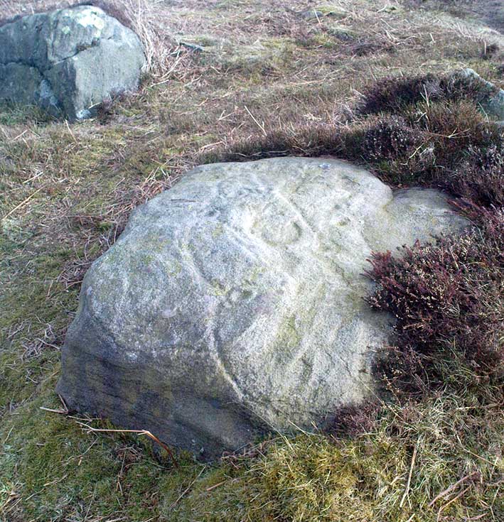
Best visited in winter and spring – thereafter the vegetation can hide it a little – but even then, it’s not too hard to find. Start from the Cow & Calf Hotel and walk across the road onto the moor, and head over as if you’re gonna walk above the Cow & Calf Rocks, onto the moorland proper. When you’ve gone a few hundred yards, walk up the slope (there are several footpaths – you can take your choice). Once on the ridge on top of the moor proper, you’ll see the Haystack Rock: it’s on the same ridge, right near where the moor drops down the slope about 250 yards west of here, just about next to the footpath that runs along the edge. Look around!
Archaeology & History
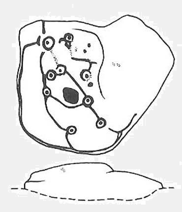
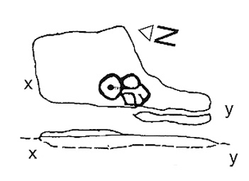
Unlike some folk who’ve seen this old stone, I find this carving superb. Its one of my favourites up here! Its alternative name – the Planet Stone – perhaps lends you to expect something more, but this is down to the astronomer who thought this was some type of heavenly image (which is most unlikely). I prefer to call it the ‘Map Stone’ because the correlates this carving has with indigenous aboriginal cup-and-rings is impressive and — to Aborigines anyway — would have all the hallmarks of a map. But not a ‘map’ in the traditional sense of modern humans. The incidence of cups and rings linked by curvaceous lines, typifies routes between water-holes or settlement spots made by ancestral beings — which is just what we find at this carving here. These ancestral beings need to be seen in a quite mythic sense: they may be creation deities (giants, gods, etc), animal spirits, the routes of shaman spirits, or other expressions of homo-religiosus.
Map Stone (note the carved line along the very edge of the rock)…and again from another angle
In the Map Stone here, we see that the very edge of the rock (fig.2 & 3) is ‘encircled’, perhaps (and I say perhaps) symbolic of the edge of the world. The lines and rings upon the top of the rock may symbolize journeys to and from important places. Another impression I get of this carving, with the “map” idea, is that the large pecked diamond-shaped ‘cup’ near the middle of the carving is a large body of water around which the archaic routeways passed. The next time anyone visits this stone, have a look at it with this idea in mind. Its simple, straightforward and makes sense (mind you – that doesn’t mean to say it’s right!).
The first account I’ve found of this comes from the pen of J. Romilly Allen (1882), where this stone “measuring 5ft 3in by 5ft, and 1ft 9in high” was described thus:
“On its upper surface, which is nearly horizontal, are carved thirteen cups, varying in diameter from 2 to 2½ in, eleven of which are surrounded by rings. There is also an elaborate arrangement of connecting grooves.”
Although we can only work our nine cup-and-rings here today, Mr Allen seemed suitably impressed with this old carving. Stan Beckensall (1999) seemed to have a good feel of this design too, describing it thus:
“Two thirds of the surface of this earthfast sandstone have been used in a design that partly encloses the marked part of the rock with long curvilinear grooves along its edge, and the inner grooves link single rings around cups. The effect is one of inter-connection and fluidity.”
Hedges 1986 sketch
The Map Stone was also looked at to examine the potential for Alexander Thom’s proposal of a megalithic inch: a unit of measure speculated to have been used in neolithic and Bronze Age times for the carving of cup-and-ring stones. Using nine other carvings on these moor as samples, Alan Davies (1983, 1988) explored this hypothesis and gave the idea his approval. However the selectivity of his data, not only in the carvings chosen, throws considerable doubt on the idea. Unfortunately the idea doesn’t hold water. The ‘geometry’ in the size of cup-and-rings relates more to the biometrics of the human hand and not early scientific geometry, sadly….
References:
Allen, J.R., ‘Prehistoric Rock Sculptures of Ilkley,’ in Journal British Arch. Assoc., 35, 1879.
Allen, J.R., ‘Notice of Sculptured Rocks near Ilkley, with some Remarks on Rocking Stones,’ in Journal British Arch. Assoc., 38, 1882.
Allen, J.R., ‘Cup and Ring Sculptures on Ilkley Moor,’ in Reliquary Illus. Archaeology, 2, 1896.
Beckensall, Stan, British Prehistoric Rock Art, Tempus: Stroud 1999.
Boughey, K.J.S. & Vickerman, E.A., Prehistoric Rock Art of the West Riding, WYAS: Exeter 2003.
Collyer, Robert & Turner, J.H., Ilkley: Ancient and Modern, William Walker: Otley 1885.
Cowling, E.T., Rombald’s Way, William Walker: Otley 1946.
Davis, Alan, ‘The Metrology of Cup & Ring Carvings near Ilkley in Yorkshire,’ Science Journal 25, 1983.
Davies, Alan, ‘The Metrology of Cup and Ring Carvings,’ in Ruggles, C., Records in Stone, Cambridge 1988.
Hedges, John, The Carved Rocks on Rombald’s Moor, WYMCC: Wakefield 1986.
Alan Davies’ image of the carving – with carved ‘lake’ near centre
Get to the famous Dick Hudson’s pub on the south-side of Ilkley Moor and go east for about 700 yards till you get to Weecher reservoir (posh doods go yachting there). From here cross the road and walk on for 150 yards till you reach the stile which takes you onto the moors. Walk! Follow the footpath and you’ll go over another wall before eventually hitting the beautiful fresh waters of Horncliffe Well (this has never dried up – even in the summers of ’76 and ’95). Sit here for a while before heading for the circle which is on the east-side of the moorland fence just a coupla hundred yards up onto the moor (you’ll cross a coupla streams before reaching the site). You’ll know you’re close when, to your left by the fence, you’ll see a boundary stone with the name ‘Thos. Pulleyn’ engraved on it.
Archaeology & History
Early drawing of Horncliffe Circle (Speight 1898)
Horncliffe is a bittova strange site, inasmuch as we don’t honestly know precisely what it is, nor its age. It used to be categorized as a ‘stone circle’, but this was abandoned many moons ago. The inner circle of this ellipse-shaped monument was thought to have perhaps contained a burial, but Victorian excavations here found no such evidence; no burials have ever been found, though fires were evidently burned in the small central ring.
Nowadays I’m of the opinion that this was more for living-in, than any ritual site. It ‘smells’ like that anyway (modern OS-maps now term it as an ‘enclosure’); and this may be borne out by the ancient name of the trackway travelling north from here called ‘Castle Gate’, meaning ‘entrance or path by the fortification.’ Faint ‘cup-markings’ reported by Harry Speight (1898) on the outer edge of the ring are very likely Nature’s handiwork.
Horncliffe is a double-ringed ellipse structure, surrounded on its northern side by a natural embankment of earth. It was first mentioned in J.N.M. Colls’ (1846) survey, but more was said of it by James Wardell in 1869, who told that,
“there is a circle of stones of various sizes, from three-feet to five-feet in height; they are chiefly set upon their edges and are of sandstone grit. This circle is forty-three feet in diameter and within it there is a smaller circle, composed of stones of the same composition…and set in the same manner.”
A few years later, the Yorkshire literary giant Harry Speight (1898) penned his first words about this curious circle, saying:
“The best example of a stone circle in the vicinity of Bingley lies on the moor close to the parish boundary, on land belonging to Mr Fawkes, of Farnley Hall. It is a complete circle, consisting of about twenty stones, placed close together (a very unusual arrangement), from two to four feet high, the circumference being about 35 yards. An excavation was made in the middle of it some years ago, when bits of flint were found, but no trace of burial. It is built on a slight slope of the moor, facing the south, and is now much concealed by heather. It is, doubtless, the oldest known evidence of man’s handiwork remaining in the neighbourhood of Bingley, and there is small doubt that it was originally intended to fence a burial, such “Druids’ Circles” being primarily meant to enclose places of sepulchre in the same way that walled enclosures came to be adopted round our churchyards. A large flat stone on the top side, about three yards distant, is marked with cups and channels, and probably was in the centre of the circle originally.”
When Arthur Raistrick (1929) visited the circle, his measurements differed somewhat from those of Mr Wardell, telling the site to have diameters of 25 feet (east-west) and 32 feet (north-south), with 46 stones in the outer ring and 17 in the inner circle.
This is one of many sites on these moors that I slept at over the years when I was a kid. It used to be a really peaceful spot that was rarely troubled by other visitors (not sure if it’s still the same though).
Folklore
Although we have nothing specific to the circle, around the nearby Horncliffe Well a coupla hundred yards away we had accounts told us by the old warden whose job it was to look after this moorland, that will-o-the-wisps had been seen here. There is a seeming alignment to the equinoxes from here to Reva Hill – though this is more fortuitous than deliberate. A dowsing survey found aquastats in and around the circle, but no plan of these were ever made.
References:
Bennett, Paul, The Old Stones of Elmet, Capall Bann: Milverton 2001.
Colls, J.N.M., ‘Letter upon some Early Remains Discovered in Yorkshire,’ in Archaeologia 31, 1846.
Raistrick, Arthur, ‘The Bronze Age in West Yorkshire,’ in YAJ 1929.
Speight, Harry, Chronicles and Stories of Old Bingley, Elliot Stock: London 1898.
Takes a bit of finding this – but if you like your rock art, it’s worth the search! You can follow directions for the getting to the Man Stone then, when you reach it, look to the near horizon to the east. Get to the bottom of the sloping hillside where a large rounded boulder sits and walk up the slope about 10 yards. Look around here cos you’re very close.
Woman Stone carvingCarving highlighted in chalk
Alternatively, from the Askwith Moor Road, follow the path to the triangulation pillar on Shooting House Hill. Keep going for another 100 yards and check a small path to your left (south). Follow this down until you get to the top of the slope. Go to the bottom of the slope and look around!
This carving is best checked out in winter and early spring: if you go here in summer & autumn there’s bracken covering the entire site & you’ll never find it!
Archaeology & History
Drawing by Inmaculada Ibanez-Sanchez
This stone was first discovered by Graeme Chappell and I during one of our many ambling explorations here in the early 1990s and was first mentioned in my Old Stones of Elmet (pp.149-152). Marija Gimbutas would have loved this seemingly matriarchal-looking cup-and-ring carving, suggestive of many Mother Goddess images she found across Europe – hence its title!
Woman Stone design (after Boughey & Vickerman)
I don’t think that the old-school archaeological types would lower themselves to say such a thing, but as I aint one of them I’m quite confident in saying that this carving does seem to be a pictorial representation of a female figure: one of the earliest of its kind in the British Isles? (check its nearby male compatriot, the Man Stone – a distinctly human figure and one of the earliest of its kind in the British Isles) Very close by we are left with old place-name remnants pointing directly at the presence of pre-christian goddess remains in the mythic landscape – an issue I’ll expand on in the near future.
In the survey by more recent rock art students Boughey & Vickerman (2003), their illustration of the carving makes it look even more like an early female figure! (though I hear they don’t like people giving the carvings names – unless, of course, one of them lot names it…)
References:
Bennett, Paul, The Old Stones of Elmet, Capall Bann: Milverton 2001.
Boughey, Keith & Vickerman, E.A., Prehistoric Rock Art of the West Riding, WYAS: Wakefield 2003.
Gimbutas, Marija, The Language of the Goddess, Harper-Collins: San Francisco 1989.
Gimbutas, Marija, The Civilization of the Goddess: The World of Old Europe, Harper-Collins: San Franciscoo 1991.