Clachan Aoraidh, Balquhidder, Perthshire

Stone Circle (ruins):  OS Grid Reference – NN 5389 2076

Also Known as:

  1. Canmore ID 24151
  2. Worshipping Stones

Getting Here

Clachan Aoraidh looking W

Along the A84 road betweeen Callander and Lochearnhead, take the small road west when you reach Balquhidder Station, towards Balquhidder village.  Go along here for 1½ miles (2.5km) as if you’re gonna visit the Puidrac Stone; but 200 yards past this, go through the gate on the south-side of the road into the boggy field for about 150 yards towards the River Balvag.  You’re looking for several stones, as in the photos.  You’ll find ’em. (you may get soaked though!)

Archaeology & History

The stones, looking NW

After many thousands of years, this innocuous-looking group of small stones found in the very boggy field immediately west of the Puidrac Stone looks nothing like it once did. Some modern academics would have you think there was nothing here of prehistoric interest, but oral tradition and earlier writings tell otherwise. Although not shown on the early OS-maps, it was first described in James Gow’s (1887) articulation on the antiquities of the area, in which he told:

“A short distance east from the present (Balquhidder) parish church, in the haugh below the manse, there are seven stones remaining of a circle which appears to have been about 30 feet in diameter; only one stone is in its original upright position, but there are fragments of others lying about; as usual, they are known as “Clachan-Aoraidh,” or worshipping stones, and are not likely to be disturbed during the lease of the present tenant.”

Looking E, with Puidrac Stone just visible left of telegraph post

A few years later when Thomas Ross (1919) visited the area with a Prof Cooper and others, they reported the single standing stone still in position and the anglicized name of the Worshipping Stones was still in evidence amongst locals.

Arc of fallen stones by the trees

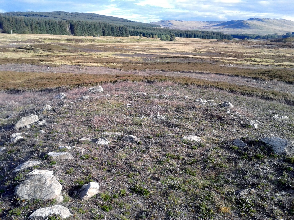
Nowadays the site is in ruin.  Two of the stones stand out when the rushes aren’t too high, with one earthfast and its companion prostrate; but as you can see in the photo (right), there remains a sunken arc of two other stones laid down, running away from the larger ones, with a fifth overgrown and nearly covered by vegetation and the young trees.  In all probability, tradition is probably right here: this is the remains of a stone circle.

Folklore

The field in which these denuded megalithic remains are found, was, wrote Thomas Ross (1919),

“the site of a long-popular market called ‘Feill Aonghais’, i.e., St Angus’ Fair.  It was held, according to Mr Campbell, in May; according to Mr Gow, on “the Saint’s Day, the 6th of April.”  It was quite the custom…to hold a fair after divine service on the Patronal Feast. The folks came to “kirk and market” on the same day, and mixed good fellowship and manly sport with their worship and their business.”

If you were to hold a fair there nowadays, likelihood is it would get flooded!  Christian myths tell of a “St. Angus” taking over whatever the heathen traditions were in this domain, more than a thousand years back.

References:

  1. Gow, James M., “Notes in Balquhidder: Saint Angus, Curing Wells, Cup-Marked Stones, etc”, in Proceedings of the Society of Antiquaries Scotland, volume 21, 1887.
  2. Ross, Thomas, “Saint Angus’ Stone, Balquhidder,” in Transactions of the Scottish Ecclesiological Society, volume 6 – part 1, 1919.

© Paul Bennett, The Northern Antiquarian


Colpy, Culsalmond, Aberdeenshire

Stone Circle (destroyed): OS Grid Reference – NJ 6411 3261

Also Known as:

  1. Canmore ID 18272

Archaeology & History

Colpy Circle site on 1868 map

Just like the stone circle a half-mile east at Kirkton of Culsalmond, nothing now remains of this megalithic ring.  It was first described very briefly by Rev. F. Ellis (1845) in the New Statistical Account as a “druidical temple”: one of two hereby, “on the farm of Colpie, although now almost obliterated. Several urns were dug up in making a road near one of them”—implying that one of them was a cairn circle or funerary monument of some kind.  This was subsequently affirmed on the early OS-map and then described in Fred Coles’ (1902) survey, where he wrote:

“Site of a stone circle, the road going to Jericho Distillery having been made through it, and, on the south side of this road, the site of a cairn. Within the possible diameter of the circle an urn was found.”

Folklore

A few hundred yards west of the circle an ancient fair used to be held, known as St Sair’s Fair, named after St Serf.  Although St Serf’s Day is July 1, early records show that the fair—held in a long field with the curious name of ‘St Sairs Market Stance’—was to be held on the Wednesday after the last Tuesday in June.  For a stone circle, this is too close to Midsummer to be a coincidence!  Early records show that the fair was granted in 1591 and subsequent years thereafter.

St Serf is a very peculiar mythological figure with quite shamanistic traits and tales around him.  In truth, many of these early saints were little more than lapsed shamans, utilising natural magick and medicine in the olde traditions, but which became grafted onto the incoming christian mythos.  The evidence for this is quite overwhelming!

References:

  1. Barnatt, John, Stone Circles of Britain – volume 2, BAR: Oxford 1989.
  2. Browne, G.F., On Some Antiquities in the Neighbourhood of Dunecht House, Aberdeenshire, Cambridge University Press 1921.
  3. Burl, Aubrey, “The Recumbent Stone Circles of North-East Scotland”, in Proceedings Society of Antiquaries, Scotland, volume 102, 1973.
  4. Burl, Aubrey, The Stone Circles of the British Isles, Yale University Press 1976.
  5. Burl, Aubrey, The Stone Circles of Britain, Ireland and Brittany, Yale University Press 2000.
  6. Coles, Fred, “Report on Stone Circles in Aberdeenshire (Inverurie, Eastern Parishes, and Insch Districts),” in Proceedings Society Antiquaries, Scotland, volume 36, 1902.
  7. Ellis, F., “Parish of Culsalmond,” in New Statistical Account of Scotland – volume 12: Aberdeen, William Blackwood: Edinburgh 1845.

© Paul Bennett, The Northern Antiquarian 


St. Constantine’s Well, Govan, Glasgow, Lanarkshire

Holy Well (destroyed?):  OS Grid Reference – NS 553 658

Archaeology & History

This is the conjectural title conferred by T.C.F. Brotchie (1920) upon a Well uncovered during construction of the Pearce Institute in Govan in 1908.  It was certainly an old site and very well made by the sound of it: being “a stone-built well some ten feet deep (and) some eight feet below the present surface of the ground.”  Brotchie thought it to be medieval in age – and he may have been right.

On asking local people if they knew anything about the site, he was lucky to meet “a very old man, a Mr Rellie”, who told him that when he was a boy his granny spoke of a lost “guid well (that) was near the kirk.”  He continued:

“I have no doubt that the well discovered in 1908 was the guid well, and judging from its proximity to the god’s acre, and also from adjective ‘guid’, that the well was at one time the holy well of St. Constantine, who in the 6th century founded a church in Govan.  Of course, that is conjecture, but I venture to think that the conjecture is reasonably well founded.”

The church is immediately adjacent and is indeed dedicated to St. Constantine.  Inside of it are a variety of fascinating archaeological relics: not least of which is what Sam Small (2008) called the ‘Pagan Sun Stone’ upon which is carved an ancient swastika!  That – I’ve got to see!

References:

  1. Bennett, Paul, Ancient and Holy Wells of Glasgow, TNA 2017.
  2. Brotchie, T.C.F., “Holy Wells in and Around Glasgow,” in Old Glasgow Club Transactions, volume 4, 1920.
  3. Small, Sam, Greater Glasgow: An Architectural Guide, Rutland 2008.

© Paul Bennett, The Northern Antiquarian 


St. Mark’s Well, Easterhouse, Glasgow, Lanarkshire

Holy Well (destroyed):  OS Grid Reference – NS 667 653

Archaeology & History

St Marks Well on 1864 map

Information on this long forgotten holy well that once flowed a few miles east of Glasgow city centre, beneath what is now Wellhouse estate, is all but lost.  Local history works of the area tell us little (though there must surely be something somewhere?) and even the place-name surveyor of this area—Peter Drummond (2014)—could find nothing.  Noted by the Ordnance Survey lads in 1858, when they came to re-survey the area again in 1899 its waters had, it seems, been covered and carried into the ‘Well house’ less about 50 yards to the southwest (another ‘Wellhouse’ found 150 yards further west is the site that gives the estate its present name).  From thereon, this wellhouse and St. Mark’s Well fell into the forgotten pages of history and, sadly it seems, even its oral tradition has died…

The origin and nature of the ‘well house’ isn’t too troublesome, as Drummond (2014) explains:

“The name Wellhouse exists in several places in Scotland, and could indicate a ‘house beside wells’, or a protective ‘house over wells’; the early record here suggests the former, since the first Glasgow Water Company’s Act was obtained in 1806, many years later.”

However, the reasons behind the dedication to St. Mark at this probably heathen arena in times gone by, seems to be quite a mystery.  Perhaps the folklore of the saint concerned may be of some help.

Customs practiced on St. Mark’s Eve and St. Mark’s Day (April 24-5) are replete with animistic elements throughout and are certainly not christian!  Six months after the old New Year, we find rituals once more allowing, not for the passing of, but the emergence of the dead: bringing the spirits into the Spring and Summer. Divination rites were practiced with Cannabis sativa no less!  Prophecy and wise-women were advisors to the young.  Walking backwards around wells were known at some St. Mark’s wells; whilst others without his name—but on this saint’s day—were leapt across, symbolizing the crossing of danger and darkness in the ritual calendar. All around this period of time, up to and including Beltane, the end of the dark cold year has passed, and these plentiful rites are prequels to the lighter days, warm spring, summer and good autumn: all vital rites for the people in their myths of the eternal return…

St. Mark’s Well at Glasgow meanwhile, seems to have lost its old tales… Surely not?

References:

  1. Banks, M. MacLeod, British Calendar Customs: Scotland – volume 2, Folk-lore Society: Glasgow 1939.
  2. Bennett, Paul, Ancient and Holy Wells of Glasgow, TNA 2017.
  3. Drummond, Peter, An Analysis of Toponyms and Toponymic Patterns in Eight Parishes of the Upper Kelvin Basin, University of Glasgow 2014.
  4. Eliade, Mircea, The Myth of the Eternal Return, Arkana: London 1989.
  5. Greene, E.A., Saints and their Symbols, Sampson Low: London 1897.
  6. Hole, Christina, Saints in Folklore, M. Barrows: New York 1965.
  7. Wright, A.R., British Calendar Customs: England – volume 2, Folk-lore Society: London 1938.

© Paul Bennett, The Northern Antiquarian 


Kirkton of Culsalmond, Aberdeenshire

Stone Circle (destroyed): OS Grid Reference – NJ 6503 3293

Also Known as:

  1. Canmore ID 18243

Archaeology & History

Site of the circle on 1873 map

After standing at the same spot for 3000 years or more, near the beginning of the 19th century this stone circle was destroyed by the self-righteous christian cult that was rampaging its way through cultures far and wide.  After all, they needed to rid the area of local traditions and “improve” the locals, whether they liked it or not!  Thankfully however, one of their creed—a reverend Ferdinand Ellis: minister of the parish for forty years—recorded its destruction in the New Statistical Account between 1834-45. Amongst a variety of important traditional monuments that once existed hereby,

“A Druidical place of worship anciently stood about the middle of the churchyard or burying ground.  It consisted of a circle of twelve upright large granite stones from Benochee, which were overturned when the first Christian temple was erected.  One of these was taken up in 1821 and now remains above ground, near the spot where it was taken up.  The other eleven are still underground.  This is proof that the first christian missionaries, in this country, erected their places of worship as near as possible to the holy hills of the heathens, that the people might be more easily persuaded to assemble there.”

Persuaded‘ being a very broad term indeed when it came to the land confiscation of indigenous folk…

The stone that Ellis said “was taken up in 1821 and now remains above ground” was gone when Fred Coles (1902) surveyed the site, but he told how an earlier antiquarian and writer for the Scottish Society of Antiquaries, J.G. Callander, lived nearby, and who was

“told by the aged sexton, Florance, that he many a time came across a great stone, when preparing graves, and that he had himself blasted these more than once.”

It seems that all trace of this single stone, and the rest of them, either still lay in the ground or were used for local building material.

When John Barnatt (1989) came to add this circle in his corpus, for some reason he postulated that

“the number of stones suggest it was a recumbent stone circle”,

…that is: a stone circle possessing one large stone in the ring that’s laid down with two standing stones either side.  However, there seems no real evidence to show that this was the case.

References:

  1. Barnatt, John, Stone Circles of Britain – volume 2, BAR: Oxford 1989.
  2. Browne, G.F., On Some Antiquities in the Neighbourhood of Dunecht House, Aberdeenshire, Cambridge University Press 1921.
  3. Burl, H.A.W., “The Recumbent Stone Circles of North-East Scotland“, in Proceedings Society of Antiquaries, Scotland, volume 102, 1973.
  4. Burl, H.A.W., The Stone Circles of the British Isles, Yale University Press 1976.
  5. Burl, H.A.W., The Stone Circles of Britain, Ireland and Brittany, Yale University Press 2000.
  6. Coles, Fred R., “Report on Stone Circles in Aberdeenshire (Inverurie, Eastern Parishes, and Insch Districts),” in Proceedings Society of Antiquaries, Scotland, volume 36, 1902.

© Paul Bennett, The Northern Antiquarian


Maypole, Hemswell, Lincolnshire

Maypole: OS Grid Reference – SK 92954 90947

Historic photo from Church Street

Also Known as:

  1. English Heritage ID: 196736

Getting Here

In Hemswell Village at the junction of Church Street and Maypole Street.

History & Archeaology

According to a 2010 report in the Scunthorpe Telegraph, the Hemswell villagers,

“claim to be the hosts to one of the oldest maypole celebrations in the world, dating back to at least 1660”.

The then clerk to the parish council, Dianne Millward is quoted as saying:

“Hemswell is widely regarded in historical circles as having one of the oldest if not the oldest celebrations for May Day. We have pictures of the pole being prepared for the big day in the very early 1900s.”

Hemswell maypole on 1906 map

This writer has not yet been able to independently verify these claims.

May Day is still celebrated in the village with dancing around the maypole and an accompanying fete. Recent online photographs show that it is now only children, in ‘historic’ fancy dress who ribbon-dance around the Pole.

© Paul T. Hornby 2016 The Northern Antiquarian


The Maypole, Alconbury, Huntingdonshire

Maypole (removed):  OS Reference Number TL 18554 75972

Getting Here

Maypole Square, outlined in red on the 1901 OS map

Maypole Square forms the junction of High Street, Church Way and Chapel Street in the centre of the village.

Archaeology & History

The Alconbury Maypole had passed out of living memory by 1942, but was historically attested by the ‘Maypole Square’ in the centre of the village.

Folklore

C.F. Tebbutt wrote in 1950:

“At Alconbury, it is remembered that about 1890 an old soldier, who lived in the corner house (east end) of the row of cottages facing Maypole Square, used to dig holes in the road opposite the row and set up May bushes there on May day”.

References:

  1. C.F.Tebbutt, “Huntingdonshire Folk and their Folklore”, in Transactions of the Cambridgeshire and Huntingdonshire Archaeological Society, Volume VI, part V, 1942.
  2. C.F.Tebbutt, “Huntingdonshire Folk and their Folklore II”, in Transactions of the Cambridgeshire and Huntingdonshire Archaeological Society, Volume VII, part III, 1950.

© Paul T. Hornby 2016 The Northern Antiquarian


The Maypole Tree, Little Paxton, Huntingdonshire

Maypole & Ritual Tree (destroyed):  OS Grid Reference TL 18831 62757

Getting Here

Imposing trunk of The Maypole Tree, right background

The road layout of the village has changed since the destruction of the Tree, but its approximate position was on the north side of the present High Street, at the junction with the east side of St James’ Road.

Archaeology & History

The Little Paxton Maypole Tree was a very late survival of a tradition where Mayday revellers danced around an actual tree rather than a symbolic tree in the form of a maypole.  It was described as “a tall straight elm tree” that stood in front of what was then the village Post Office, and from what may be the only surviving photograph, it appears that only the very substantial trunk survived of what was clearly a very old tree.

The 1887 6" OS Map, showing the Maypole Tree outlined in red
1887 6″ OS Map, showing the Maypole Tree outlined in red

A Miss Ethel Ladds, who had been born in Little Paxton, recalled in the early 1940s:

I remember the old tree very well, it was always called ‘the Maypole’, but I don’t know any more about it, except that they used to dance round it“.

The St Neots Advertiser recorded that the Maypole Tree was blown down in a great gale on 24th March 1895.

Folklore

While this writer has been unable to find direct folklore relating to the Little Paxton Maypole Tree, it may be worth remarking that botanically the Elm tree is a cousin of the Stinging Nettle, the Hop and Cannabis.  Another Elm Tree used for May revels was the Tubney Elm, near Fyfield in Berkshire and recorded by Matthew Arnold, in his ‘Scholar Gipsy’.

References:

  1. C.F. Tebbutt, “Huntingdonshire Folk And Their Folklore”, in Transactions of the Cambridgeshire & Huntingdonshire Archaeological Society, Volume VI, Part V, 1942
  2. C.F. Tebbutt, “Huntingdonshire Folk And Their Folklore”, in Transactions of the Cambridgeshire & Huntingdonshire Archaeological Society, Volume VII, Part III, 1950
  3. Gerald Wilkinson, Epitaph For The Elm, Arrow Books, London, 1979

© Paul T. Hornby 2016 The Northern Antiquarian 


Shaman’s Lodge, Glen Cochill, Perthshire

Hut Circles:  OS Grid Reference – NN 90591 41247

Getting Here

The large double hut circle, surrounded by tombs

Take the same directions to reach the giant Carn Ban prehistoric tomb. Follow the track past the tomb further onto the moorland until you reach a small wooden bridge over the small burn.  From here, walk straight north off-path onto the moor for 100 yards and a small rise in the land, with several cairns just below it, is the site in question.

Archaeology & History

Hut circle are hut circles – right?  Well, usually that’s the case.  We find them attached to, or within, or outlying prehistoric enclosures and can date from anywhere between the neolithic and Iron Age periods.  With the site we’re looking at here, on the outer western side of Glen Cochill’s southernmost giant enclosure, there’s something amiss….or maybe that should be, “something rather peculiar.”

Mr Hornby, hut-side
Mr Hornby, hut-side
Shamans Lodge walling

Paul Hornby found it a few weeks ago during an exploration of the region’s prehistory. We went in search of, and found, the giant Carn Ban close by, but noticed curious archaeological undulations ebbing in and out of the heathlands: cairns, walls, hut circles, settlements, more cairns—and then this!

Consisting of two slightly larger-than-average ovals of walled stone, probably Bronze Age in date, the first impression was of a remarkably well-preserved site (and that it is!), seemingly of an elongated stretch of walling, with a central wall that split it into two halves.  Each ‘hut circle’ was found to be between six and seven yards across, with the two conjoined architectural features giving an overall NW-SE length of 14 yards.  But the more we looked at this, the more obvious it became that this was originally one single hut circle—the lower southeastern one—with an additional one that was added and attached onto the northwestern side at a later date, probably several centuries later.

Lower earlier hut circle, with upper later hut circle attached

Walking around the structure we found that the very well-preserved walls—about 2 feet wide in places and rising a foot or so above the compacted peat—had been built onto a raised platform of earth.  This was no ordinary hut circle!  The ground beneath it seems to have been raised and supported and on the southern side in particular it is notable that other building stones are compacted into the peat.  There may even be the remains of a secondary outer wall on this southern edge, where it seems that the entrance was made.

Small group of cairns 15 yards away

Here’s the curious bit: immediately outside the northwestern and southern walls are small prehistoric tombs, or cairns.  Not just one or two, but more than a dozen of them, all constructed within 20 yards of this curiously raised double hut circle.  Literally, a small prehistoric house of some form was raised in the centre of a prehistoric graveyard—and it doesn’t end here.

Of at least three giant enclosures in this region, and what looks like a very well-preserved prehistoric tribal hall or meeting place, there are upwards of a hundred tombs scattered nearby.  Two cairn circles were also found about 100 yards to the north, one of which was damaged by a military road a few centuries ago.

Close-up of walling
Close-up of walling

I give this double-roomed abode the somewhat provocative title of the Shaman’s Lodge because of its setting: surrounded by tombs, the ‘house’ would seem to have been a deliberate setting erected in the Land of the Dead here.  I hope you can forgive my imaginative mind seeing this as a structure where, perhaps, a medicine woman would give rites to the dead, either for those being buried in the small graves, or rites relating to the giant White Cairn of the ancestors close by.  Shamans of one form or another occur in every culture on Earth and have been traced throughout all early cultures.  If no such individuals ever existed within the British Isles, someone needs to paint one helluva good reason as to why they believe such a thing….

When the heather grows back here, the site will disappear again beneath the vegetation.  It is unlikely to re-appear for quite sometime, so I recommend that anyone wanting to have a look at this does so pretty quick before our Earth covers it once again….

References:

  1.  Stewart, Margaret E.C., “Strath Tay in the Second Millenium BC – A Field Survey”, in Proceedings Society Antiquaries Scotland, volume 92, 1961

Acknowledgements:  Huge thanks again to Paul Hornby for his assistance with site inspection, and additional use of his photos.

© Paul Bennett, The Northern Antiquarian


St. Mungo’s Well, Gleneagles, Perthshire

Holy Well:  OS Grid Reference – NN 9376 0719

Also Known as:

  1. Canmore ID 25905

Getting Here

St Mungo's Well, Gleneagles
St Mungo’s Well, Gleneagles

The best way here is to walk a mile to find it.  All the way up the road from Gleneagles Standing Stones to Glendevon, right at the very top where the two glens meet, there’s a small road heading to the Fishery. 100 yards along, park up. Then take the old green road back down the Glen, north towards Gleneagles, parallel with the new road. A mile or so down you’ll reach the farmhouse, but a coupla hundred yards before this, in a wooden gap in the electric fence, you can walk straight downhill to the large pool below you. Y’ can’t really miss it!

Archaeology & History

The strong cold spring of water known as St Mungo’s Well, now gathers into a large crystal clear pool and is gorgeous to drink and very refreshing!  All around the edges are the brilliant yellow masses of gorse, held amidst widespread vivid hues of green in this most rocky of landscapes.  Tis a gorgeous setting here….

St Mungo's Well, 1860 map
St Mungo’s Well, 1860 map

Unfortunately there is no literary information that tells us why this spring of water, amongst the many others all around these hills, gained the ‘blessing’ of one of those roaming christians and was deemed to be ‘holy’.  The greatest likelihood, as usual, is that the waters had some important heathen association which our peasant ancestors would have been able to tell us about if their animistic tales hadn’t been outlawed and demonized by the incoming cult — but we’ll probably never know for sure.  As a result, we know nothing now of its medicinal qualities or old stories.

The transference of its old name (whatever it may have been) to their ‘St. Mungo’ may date from when the character was wandering with his christians in the 7th century, but we have no literary account proving as such.  The name ‘St Mungo’ was an alternative name (a nickname if y’ like) of St. Kentigern — or at least that’s what the church historians tell us.  There is no history of Kentigern or St Mungo up the glen, but we do have a more prosaic account that tells of a Mr Mungo Haldane of Gleneagles, a member of the Scottish parliament in 1673 onwards; he was succeeded by another Mungo Haldane MP in 1755.  However, it’s highly unlikely that these political characters gave their name to the well.

The clear waters, looking south
Crystal clear perfect drinking water

Even the Scottish holy wells surveys are pretty silent on this beautiful site.  It was mentioned in Morris’ (1981) survey, but with no real information.  The earliest account seems to come from an article written in the Perthshire Advertiser in 1856, and thankfully reproduced in the otherwise tedious genealogical history of the Haldane (1880) family; but even here, the narrative simply mentions the presence of the well and no more.  Described in a walk up Gleneagles, it told:

“Journeying westward along the desolate moor…we soon came in front of Gleneagles, a narrow picturesque glen in the Ochils, through which the old road from Crieff leads into Kinross-shire.  The hills here, as throughout the whole range, are strictly pastoral, but in no place more so than Gleneagles.  Crowning the heights on both sides of the glen, we have craigs ragged and bare enough; but their show of beetling hard sterility is as nothing to the winding receding mass of grassy heights that bound the view. In looking on that quiet, sunny, Sabbath-like retreat, one would be apt to deem the name a misnomer, and yet it is not much above a hundred years since the monarch of birds had a home among its cliffs.  There, too, the Ruthven Water that dashes past Auchterarder has its rise — not in a scarcely seen bubbling spring almost covered with moss, but issuing at once into daylight at the bottom of yonder steep in volume sufficient to drive a mill.  In ancient times, as now, it must have been an object of mark, as it is called St. Mungo’s Well; but who this St. Mungo or St. Magnus was — whether the ghostly patron of Glasgow, Auchterarder old chapel, or the guardian saint of this particular spot, we cannot tell.  But he seems to have relished cold water; and it is satisfactory to know that he must have got his fill of it there, if his cell happened to be in the vicinity.”

The well was mentioned in passing in the Object Name Book in 1860 and shown on the earliest Ordnance Survey maps.

Folklore

Apart from the fact that the waters here never run dry, we have no other folklore. However it should be noted that St. Mungo’s Day was January 14th — which may have been when the qualities of the spring were deemed most efficacious, or when olde rites were enacted here.  However, a hundred yards down we pass the stream known as Bride’s Burn, probably in honour of the heathen Queen St. Brigit, whose name and myths are integral to our great Earth goddess, the Cailleach and whose celebration date is only two weeks later than that of Mungo.  Hmmmmmmm…..

References:

  1. Attwater, Donald, Penguin Dictionary of Saints, Penguin: Harmondsworth 1965.
  2. Haldane, Alexander, Memoranda Relating to the Family of Haldane of Gleneagles, C.A. MacKintosh: London 1880.
  3. MacKinlay, James M., Folklore of Scottish Lochs and Springs, William Hodge: Glasgow 1893.
  4. Morris, Ruth & Frank, Scottish Healing Wells, Alethea: Sandy 1982.
  5. Watson, Alexander, The Ochils – Placenames, History, Tradition, Perth & Kinross District Libraries 1995.

© Paul Bennett, The Northern Antiquarian