Worth the short trek if you like your cup&rings! On the Aire Valley Keighley-to-Skipton road (A629), as you approach the southern outskirts of Skipton, take the turning at the roundabout as if you’re going into the town up the A6131. Go over the next roundabout a coupla hundred yards on, then 200 yards further on note the right-turn up over the canal (big hotel just here, where you could park up). Walk over the canal up the tiny country lane. Ignore the first left turn and walk up, bearing next left uphill and onto the footpath. Walk up the hillocky quarried bit until you reach the stile in the wall. Once on the other side, look in the walling 20 yards uphill. You can’t miss it!
Archaeology & History
First described by Messrs Hartley and Radley in the Yorkshire Archaeological Register of 1968, this small “standing stone”, less than three-feet tall, has a distinct cup-and-double- ring carved onto its upright north-facing edge. The outline of the carving is visible even in bad light, though you might wanna rest and gaze for a minute or two for yourself and the lighting to adjust if it’s a grey day. There’s another cup-marking below the bottom right of the double-ring, with another ‘possible’ just above ground-level.
References:
Boughey, Keith & Vickerman, E.A., Prehistoric Rock Art of the West Riding, WYAS: Leeds 2003.
Hedges, John (ed.), The Carved Rocks on Rombald’s Moor, WYMCC: Wakefield 1986.
There is very little known of this once proud standing stone, said by one writer to have been about 12 feet long: six-feet of it in the ground and the other six-feet above ground. A decent monolith by anyone’s standard! But some dickheads forty years or more ago thought it a good idea to destroy the site, or as it was diplomatically put, “was removed in advance of road widening.” Vandalism no less – though it’s demise was recorded by the Department of the Environment “on behalf of the Inspectorate of Ancient Monuments.” (DES, 1973)
A local journalist called Andrew McCallum described the site in his unpublished manuscript on the history of the parish of Mansewood, telling it to be near Cowglen:
“near Boydstone Road, midway between Kennishead and Barrhead Road. 6 feet above the ground, and at least as many below. Age and purpose are unknown.”
Some thirty years later, Miss Adamson (1973) told us that,
“The straight-sided block had its base set on yellow sandstone. Immediately above the bedrock small stones and earth had been packed against the W and N faces of the standing stone. On top of the packing were two boulders set at right angles to wedge the sides of the stone. No burials or cremations were found.”
Though on this latter remark we have to consider the possibility that the standing stone may once have accompanied a burial, as the nearby place-name ‘Carnwadric’ indicates a cairn, or burial site. A field-name survey of the immediate region may prove valuable.
References:
Adamson, H., “Glasgow: Boydstone Road – Standing Stone,” in Discovery & Excavation in Scotland, 1973.
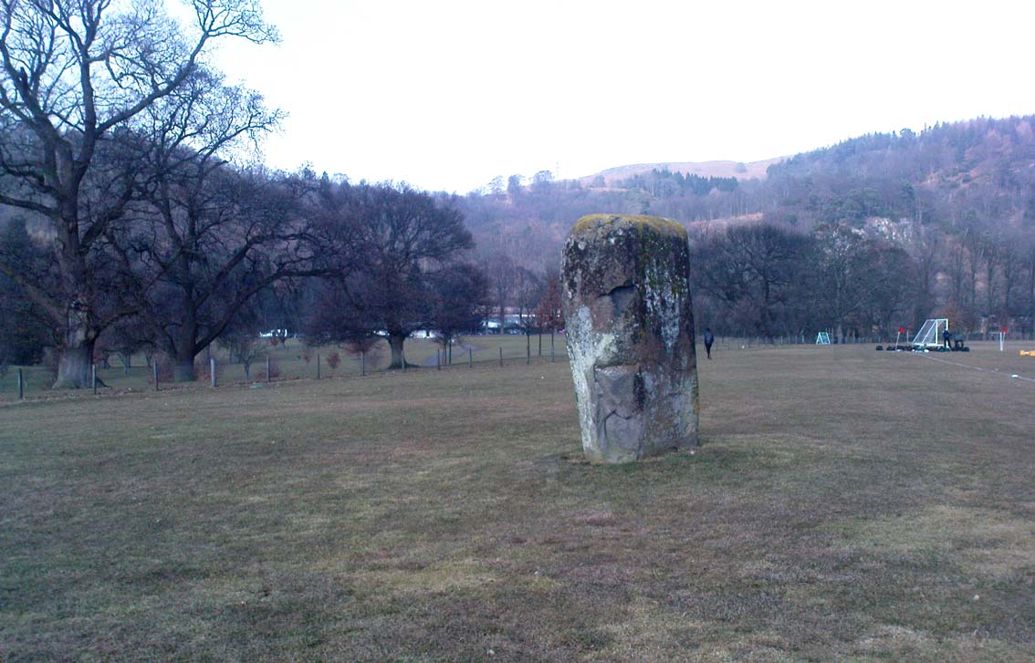
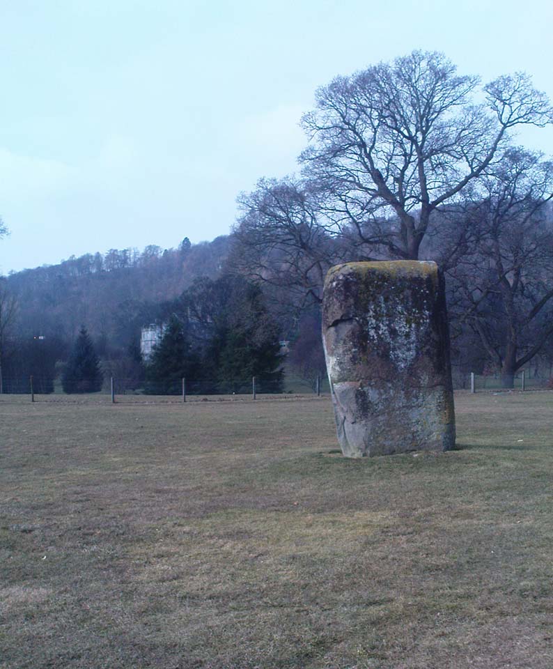
Dead easy to find! From Stirling head out on the A9 road towards Bridge of Allan and Stirling Uni. You’ll hit a small roundabout a mile out of Stirling – go straight across and up the little bendy road. Follow this round the bottom side of the Uni for a half-mile, watching out for the left-turn as the tree-line ends, taking you up to the factory behind the trees (if you hit the roundabout a bit further on, you’ve gone too far!). Go up the slope and onto the level sports playing fields – where this old beauty will catch your eye! If you somehow miss it, just get to the Uni and ask some of the students where it is!
Archaeology & History
Airthrey Stone, looking NW
This single standing stone is a beauty! It’s big – it’s hard – and it’s bound to get you going! (assuming you’re into megaliths that is) Standing proud and upright on the eastern fields of the Stirling University campus, A.F. Hutchinson (1893) measured it as being “9ft 1in in height. Its greatest breadth is 4ft 10in, and its circumference 14ft.” A bittova big lad! More than fifty years later when the Royal Commission (1963) lads got round to measuring its vital statistics, only an inch of the upright had been eaten by the ground. The stone was highlighted on the earliest OS-maps of the area.
Folklore
Of the potential folklore here, most pens and voices seem quiet; although Mr Hutchinson (1897) told of William Nimmo’s early thoughts, linking the history of this stone with the others nearby, saying:
“Of what events these stones are monuments can not with certainty be determined. In the ninth century, Kenneth II, assembled the Scottish army in the neighbourhood of Stirling, in order to avenge the death of Alpin his father, taken prisoner and murdered by the Picts. Before they had time to march from the place of rendezvous, they were attacked by the Picts… As the castle and town of Stirling were at that date in the hands of the Picts, the rendezvous of Kenneth’s army and the battle must have been on the north side of the river; and as every circumstance of that action leads us to conclude that it happened near the spot where these stones stand, we are strongly inclined to consider them as monuments of it. The conjecture, too, is further confirmed from a tract of ground in the neighbourhood which, from time immemorial, hath gone by the name of Cambuskenneth: that is, the field or creek of Kenneth.”
And although this hypothesis is somewhat improbable, it was reiterated in the new Statistical Account of 1845, which also suggested that this and the other Pathfoot Stone were “intended probably to commemorate some battle or event long since forgotten.”
References:
Hutchinson, A.F., “The Standing Stones of Stirling District,” in The Stirling Antiquary, volume 1, 1893.
Royal Commission on the Ancient & Historical Monuments Scotland, Stirling – volume 1, HMSO: Edinburgh 1963.
Pretty easy to find. Head down the B8051 road south, out of Stirling, for a ¼-mile. Keep your eyes peeled for the central police station on your right as you come out of town. The stones are on the grassy forecourt in front of the police station!
Archaeology & History
It’s amazing that these stones are still standing! Jut out of the city centre, very close to the main road and right outside the central police station: if these standing stones would have stood anywhere in England, they’d have been destroyed. Thankfully, the Scots have more about them regarding their history, traditions and antiquities.
Randolphfield stone SWNE Randolphfield stone
Of the two stones that remain here, they stand in (just about) the same position that they were shown as on an 1820 map of Stirling. The northernmost of the two is about 3½-feet tall and rests upright against the edge of the track and lawn; whilst its taller companion — knocking close on to six-feet tall — stands proudly near the middle of a well-kept lawn less than 50 yards away. Once you’ve found one, the other’s easy to spot!
It’s obvious that the larger of the two stones was cut down at some time in the recent past, as there are several blatant cuts where the standing stone had been snapped into at least three portions — but whoever did the damage was given a bittova bollocking, as the stone was cemented back into its near-original form and stood back upright again. To this day, as one of the female officers coming out of the station indignantly told me, “they’re protected!” Long may they stay that way!
In Mr A.F. Hutchinson’s (1893) early description of these stones he told that they stood “in a line from SW to NE — the line of direction making an angle of 235° with the magnetic north.
“The southwest stone stands 4ft above the ground. The portion underground measures 2ft 5in; so that in all it measures 6ft 5in. Its girth is 6ft 6in. It is four-sided in shape—nearly square—three of the faces measuring each 21 inches, and the fourth 15 inches. The northeast stone is smaller and less regular in form. Its height above ground is 3ft 6in, and its girth 4ft 6in. Both stones are pillars of dolerite, of the same material as the pillar stones of the Castle rock, from which place they have apparently been brought. The larger stones shows some marks on it, which have been supposed to be artificial. They are , however, merely the natural joints characteristic of these blocks…”
Folklore
Like many standing stones scattering our isles, this site possesses the old tradition of them marking a battle — in this case, the Battle of Bannockburn. Once again, Mr Hutchinson (1893) wrote:
“The local tradition as to the origin and meaning of these stones is well-known. It is thus stated by (William) Nimmo in his History of Stirlingshire, p.84…: ‘Two stones stand to this day in the field near Stirling, where Randolph, Earl of Murray, and Lord Clifford, the english general, had a sharp encounter, the evening before the great battle of Bannockburn.’ Again, p.193:- ‘To perpetuate the memory of this victory…two stones were reared up in that field and are still to be seen there.’ …The Old Statistical Account of St. Ninians (Rev. Mr Sheriff, 1796), makes the same statement, p.406-8:- ‘In a garden at Newhouse, two large stones still standing were erected in memory of the battle fought on the evening before the battle of Bannockburn, between Randolph and Clifford.'”
Yet the name ‘Randolphfield’ is apparently no older (in literary records) than the end of the 17th century and the thoughts of Hutchinson and other local historians is that the two stones here, whilst perhaps having some relevance to an encounter between the Scots and the invading english, were probably erected in more ancient times.
References:
Hutchinson, A.F., “The Standing Stones of Stirling District,” in The Stirling Antiquary, volume 1, 1893.
Royal Commission on the Ancient & Historical Monuments Scotland, Stirling – volume 1, HMSO: Edinburgh 1963.
Follow the same directions as those to reach the small Central Design Stone up past the top-end of Shipley Glen. You’ll notice the small disused quarry just a few yards away, and this partly-covered flat stone lies right at the very edge of the quarry itself.
Archaeology & History
Faint cups on CR-122Plan of CR-122 (after Hedges)
Unless you catch this stone in good light, many of the cups on this design are difficult to make out; but defocus for a bit and they’ll come to you. Around 13 cups have been counted on this stone, with a couple of grooves: one of which descends just by the small arc (a common local feature on Baildon’s carvings), near the eastern side of the stone. A larger basin below this, covered by earth, may or may not be natural. Two of the cups here may have been carved sometime in the late 19th or early 20th century, probably around the time the quarrying was being done.
As is common in some parts of Britain, this carving (and others nearby) was found in association with a small cairn-field, much of which has long since gone.
It’s very probable that there were other petroglyphs close to this one, but which have subsequently been destroyed as a result of the quarrying operations here.
References:
Baildon, W. Paley, Baildon and the Baildons – parts 1-15, Adelphi: London 1913-1926.
Bennett, Paul, Megalithic Ramblings between Ilkley and Baildon, private manuscript: Shipley 1982.
Boughey, Keith & Vickerman, E.A., Prehistoric Rock Art of the West Riding, WYAS: Leeds 2003.
Jackson, Sidney, “Cup-Marked Boulder near the Glovershaw Footpath,” in Cartwright Hall Archaeology Group Bulletin, 2:17, 1957.
Hedges, John, The Carved Rocks on Rombald’s Moor, WYMCC: Wakefield 1986.
Best visited out of season before the corn’s been planted. It makes it easier to find and doesn’t annoy the land-owner here, who tends to be a decent dood. From Chipping Norton go southeast along the B2046 road to Charlbury. After about 1½ miles take the second right turning down the small country lane. Go slowly down here for less than half a mile, watching the fields on your right. You’re damn close!
Archaeology & History
The Hawk Stone
This impressive, weather-worn, eight-foot tall standing stone stands aloft in the middle of a field due west of the road between Chalford Green and Dean. It’s an excellent monolith and one which, I think, has a lot more occult history known of it than described here. Thought by O.G.S. Crawford (1925) and others in the past to have been “formerly part of a chambered structure,” or prehistoric chambered tomb like that of the Hoar Stone at nearby Enstone, no remains of such a structure unfortunately remain today. It is first illustrated and named on a local map of the region in 1743 CE, and the stone at least has fortunately managed to escape the intense agricultural ravages endemic to this part of the country.
The name “Hawk” stone has been fancied by some to relate to some obscure resemblence to a Hawk, or because there very often are hawks hovering over those upland fields – but these are unlikely. It’s thought by place-name authorities more likely to derive from a corruption of ‘Hoar’ meaning a grey or boundary stone; and as it stands just yards east of the present township boundary line, this derivation seems more probable.
To all lovers of megalithic sites, we highly recommend a visit here!
Folklore
In local folklore and in the opinion of some earlier historians, the Hawk Stone formed an integral part of a stone circle here, but there is little known evidence to substantiate this.
Hawk Stone in summerHawk Stone in winter
A creation legend attached to this site tells that the stone was thrown, or dragged across the land, by a old witch or hag — though we are not told from where. This is a motif found at megalithic sites all across the country (see Bord & Bord 1977; Grinsell 1976, etc). In Corbett’s History of Spelsbury (1962) the author told of the folklore spoken of by one Mr Caleb Lainchbury who
“said the cleft at the top of the Hawk Stone at Dean was supposed to of been made by the chains of the witches who were tied to it and burnt. As witches seem to have been extremely rare in Oxfordshire it cannot have been a very common practise to burn them at Dean; but there may indeed have been some kind of fire ceremonies near the stone.”
Grinsell (1976) also tells how the Hawk Stone has that animistic property, bestowed upon other old monoliths, of coming to life and going “down to the water to drink when it hears the clock strike 12.”
This evidently important and visually impressive monolith also plays an important part in an incredibly precise alignment (ley) running roughly east-west across the landscape. At first, Tom Wilson (1999) thought the alignment had previously gone unnoticed, but later we later found a reference to the same line in an early copy of The Ley Hunter (Cooper 1979). It links up with other important megalithic sites, such as the Hoar Stones at Enstone, Buswell’s thicket, and the ancient Sarsden Cross.
Similarly, when Tom Graves’ (1980) was doing some dowsing experiments at the Rollright stone circle a few miles west, he found what he described as an ‘overground’ (or ley) linking the ring of stones to the Hawk Stone, but no other connecting sites are known along this line.
References:
Bennett, Paul & Wilson, Tom, The Old Stones of Rollright and District, Cockley: London 1999.
Bord, Janet & Colin, The Secret Country, BCA: London 1977.
Cooper, Roy, “Some Oxfordshire Leys,” in The Ley Hunter, 86, 1979.
Corbett, Elsie, A History of Spelsbury, Cheney & Sons: Banbury 1962.
Crawford, O.G.S., The Long Barrows of the Cotswolds, John Bellows: Gloucester 1925.
Gelling, Margaret, The Place-Names of Oxfordshire – volume 2, Cambridge University Press 1954.
Graves, Tom, Needles of Stone, Granada: London 1980.
Grinsell, L.V., Folklore of Prehistoric Sites in Britain, David & Charles: Newton Abbot 1976.
Thor Stone, Taston, hiding in shadows on bright sunny day
Very easy! From which ever direction you approach the gorgeous little village of Taston, get to the Cross in the middle of the road and look up the slight hill and at the old walling on the right-hand side. You can’t really miss it!
Archaeology & History
An impressive seven-foot tall standing stone resting up against the walling of Martin and Martha’s Thorstone Cottage, and which appears to have been recorded as far back as the late thirteenth century in the survey of the Chadlington hundred. Indeed, according to the respective place-name authorities, the village of Taston itself appears to get its name from the Thor Stone, as it’s recorded as Thorstan in 1278 CE. (Gelling 1954)
Less than 100 yards away is a large old stone cross, the top of it now fallen, which may once have had some earlier pre-christian relationship with the Thor Stone; perhaps originating from other standing stones close by our now solitary Thor Stone (see Folklore, below). No other monoliths or prehistoric tombs are presently associated with this site, but its folklore tells of earlier companions…
More than a hundred miles north of here we find an etymological sister in the old village of Thurstaston and where, not surprisingly, we have another Thor’s Stone — but in this instance the name applies to a huge rock outcrop with old pagan legends attached.
Folklore
Elsie Corbett (1962) tells that the creation myth for this stone was that it originated after the great god Thor cast a thunderbolt down from the heavens and this stone appeared as a result. But more intriguing from an archaeological perspective is what Mike Howard (he of The Cauldron magazine) told us in a short article for the Gloucester Earth Mysteries magazine in 1994, which said that our grand old Thor Stone was once part of a stone circle. He wrote:
“At Taston…are the rather battered remains of a megalithic circle known locally as the Thor Stones. It seems the original circle was dug up many years ago and the stones now reside in a neat pile at the crossroads in the centre of the village. The whole edifice resembles nothing less than an eccentric market cross, topped by a phallic stone.”
Although he doesn’t cite any sources for this bit of info (where’d you gerrit from Mike?), we need to take a more careful look at the old cross nearby. And we find another piece of folklore relating to the Taston cross which said that it was placed there to abate the evil influences that were supposed to come from the Thor Stone. This piece of folklore is simply one laid down by the Church which portrayed most things it did not understand, or sought to repress, as being the work of their own demonic power, Satan.
Between these two old monuments was once a huge old elm tree which, says Caroline Pumphrey (1990), was a meeting place of the local villagers in times gone by. Whether this implies the Thor Stone to have been a moot spot is difficult to tell, although the erection of the cross would seem to add weight to this.
More recent screwy notions comes from one woman who reckoned, curiously, that the Thorstone got its name from some completely invented made-up goddess, saying:
“I believe its more likely to be a corruption of the name of ‘Hoar’, the great Goddess. Indeed the Hawk Stone, and various Hoar stones stand widely hereabouts and probably derived their names from the same deity.”
Utter drivel of course (there’s no such goddess as Hoar)! But — like the christians and others before them — people believe what they want to believe and this sorta nonsense is increasingly found all over the internet. As is well known, the word hoar derives from ‘har’, being ‘grey’ or ‘a boundary’ (Gelling, 1954; Smith 1956); and numerous studies show this quite clearly.
References:
Bennett, Paul & Wilson, Tom, The Old Stones of Rollright and District, Cockley: London 1999.
Corbett, Elsie, A History of Spelsbury, Cheney & Sons: Banbury 1962.
Gelling, Margaret, The Place-Names of Oxfordshire – volume 2, Cambridge University Press 1954.
Grigson, Geoffrey, The Shell Country Book, George Rainbird: London 1962.
Howard, Mike, ‘From Thor to Rollright,’ in Gloucestershire Earth Mysteries 18, 1994.
Pumphrey, Caroline, Charlbury of our Childhood, Sessions Book: York 1984.
Smith, A.H., English Place-Name Elements – volume 1, Cambridge University Press 1956.
From the old Glen House pub, walk up the road onto ‘Shipley Glen’ as all locals call the place. Go up the Glen Road for about half a mile, watching out for the small dirt-track turning going the slope on your left-hand side just near where the road starting swerving uphill to the right. At this point where the track heads down and into the trees, there’s a footpath going into the bracken along to the right, heading onto level ground. Walk up and along here. After 100 yards or so you’ll notice the disused quarry on your left. Keep walking along the footpath (two end up running parallel to each other) and you’ll see this carving right beneath your feet!
Archaeology & History
Baildon Moor carving 126
This was one of the very first examples of “cup and ring stones” that I ever saw, when I was a mere 10 or 11 years old! I’m not quite sure what I expected to find, but something about this stone with its deeply set cup-markings obviously had an effect on me – as I’m still foraging about looking at them more than 35 years later! About 20 yards away from the Glovershaw quarry carving (Baildon Moor 122), this central design stone — as I used to call it — was first recorded in W. Paley Baildon’s (1913) magnum opus and was then all-but-forgotten until the Bradford Archaeology Group mentioned it again more than forty years later. Although you can only see three distinct cups on this small rock, another 2 or 3 seem in evidence under better lighting conditions, and a small line runs below the cups in the photo here, which you can just make out above the central cup.
This carving and others close by give the distinct impression that they were once part of some seemingly lost cairn-field, awaiting rediscovery…
References:
Baildon, W. Paley, Baildon and the Baildons – parts 1-15, Adelphi: London 1913-1926.
Bennett, Paul, Of Cups and Rings and Things, unpublished: Shipley 1981.
Bennett, Paul, Megalithic Ramblings between Ilkley and Baildon, unpublished: Shipley 1982.
Boughey, Keith & Vickerman, E.A., Prehistoric Rock Art of the West Riding, WYAS: Leeds 2003.
Cowling, Eric T., Rombald’s Way, William Walker: Otley 1946.
Hedges, John, The Carved Rocks on Rombald’s Moor, WYMCC: Wakefield 1986.
Cup-and-Ring Stone (destroyed): OS Grid Reference – NT 138 746
Archaeology & History
Lost carving of Carlowrie
Two-thirds of a mile west of the Cat Stane, on land immediately north of the River Almond by Edinburgh Airport in an area that was reported in 1780 to be “filled with the skeletons of human bodies,” this old petroglyph could once be found. The Scottish Royal Commission (1929) described it as being a covering stone for a short prehistoric tomb near the OS-grid reference cited here, “but when discovered it was much broken by the plough that it does not appear to have been preserved.” They refer instead to the last report of the site in the Scottish Society of Antiquaries journal, where we were informed that the cover stone was,
“marked with three series at least of concentric circles… The widest diameters of the sets of rings cut on the inside of the lid is about five inches, and each set is composed of five concentric circles.”
All trace of this carving appears to have been lost. Other carvings reported nearby in the 19th century also appear to have been lost or destroyed.
References:
Morris, Ronald W.B., The Prehistoric Rock Art of Southern Scotland, BAR 86: Oxford 1981.
Royal Commission on Ancient & Historical Monuments, Scotland, Midlothian and Westlothian, HMSO: Edinburgh 1929.
Simpson, J.Y., The Cat-Stane, Edinburghshire, Neill & Co: Edinburgh 1862.
Simpson, J.Y., “On Ancient Sculpturings of Cups and Concentric Rings,” in Proceedings of the Society of Antiquaries, Scotland, volume 6, 1864-66.
James Fergusson’s drawing of both cursus monuments
Just like its much larger companion, the Stonehenge Cursus earthwork a short distance to the south, this Lesser or Small Cursus is generally deemed by archaeologists to “speak of a clear religious or ritual aspect to this patch of downland that…reaches back generations before the first Stonehenge was built.” (Pitts 2001) The monument was aligned roughly east-west, showing possible relationships with the rising and setting of both sun and moon. (though I wouldn’t get too carried away with that misself…)
When Fergusson (1872) described this and its larger cursus companion a few hundred yards away, he thought they may have been dug to mark out lines of battle in prehistoric times, denouncing the horse-racing course hypothesis that was still in vogue at the time. His theory drew evidence from the numerous prehistoric tombs scattering this area of Salisbury Plain, but seemed more influenced by notions of prehistoric barbarism and warfare than ideas relating to a cult of the dead — which was yet to reach it heights in the archaeological minds of Victorian England. But, like other cursus monuments all over the British Isles, this one also seemed to have a distinct relationship with monuments of the dead: for at its western extremity (until being ploughed out of existence) was a large round barrow, catalogued as the “Winterbourne 35” tomb. Tim Darvill (2006) tells its wider tale:
“Levelled by ploughing between 1934 and 1954, the Lesser Cursus was investigated in 1983 as part of the Stonehenge Environs Project… Three trenches were cut into different parts of this large monument, showing that there were at least two main phases to its construction. Phase 1 comprised a slightly trapezoidal enclosure 200m by 60m, whose ditch may have been recut more than once and in part at least deliberately back-filled. In Phase 2 this early enclosure was remodelled by elongating the whole structure eastwards by another 200m. This extension comprised only two parallel side ditches, making the whole thing about 400m long with a rectilinear enclosure at the west end with entrances in its northeast and southeast corners giving access into a second rectilinear space, in this case open to the east.”
Lesser Cursus aerial viewGround-plan of the Lesser Cursus (after Richards 1990)
The entire structure had finds dating from the periods between 3650-2900 BC; and the aerial imagery showing an oval-shaped structure near the eastern end was confirmed by geophysical surveys — though precisely what this is has yet to be ascertained.
It seems likely that this and other cursus monuments were, to a very great degree, not only related to mortuary practices but — as their development occurred at the same time as the destruction of Britain’s great forests began — to be monuments to the gods themselves. This seems very evident at a couple of cursus monuments where animal deposits were made in some of the great mounds at their terminii, where archaeologists had previously assumed— incorrectly — the mounds to have been human burial mounds. More about this in due course…
References:
Darvill, Tim, Stonehenge: The Biography of a Landscape, Tempus: Stroud 2006.
Devereux, Paul, The Haunted Land, Piatkus: London 2001.
Fergusson, James, Rude Stone Monuments in all Countries, John Murray: London 1872.
Loveday, Roy, Inscribed Across the Landscape, Tempus: Stroud 2006.
North, John, Stonehenge, Harper-Collins: London 1997.
Pitts, Mike, Hengeworld, Arrow: London 2001.
Richards, Julian, The Stonehenge Environs Project, English Heritage: London 1990.


")

")