Looking dead straight from the Hill of Ballunie to Leys.
There seems to be nothing left of the stone circle described in Andrew Jervise’s (1879) immense work which, sadly, only described this stone circle in passing. He told us simply that hereby, “are also the remains of stone circles upon the hill of Ballunie,” which is just a few hundred yards along the road from the magnificent Keillor Pictish symbol stone. When we visited the place not long ago, no trace of any stones were visible hereby. The site is not listed in Burl’s (2000) magnum opus.
However, ley-hunters will love this place. Not only was this lost circle located at the edge of a dead straight road, running from the Keillor standing stone a short distant east, but as it runs downhill it reaches, a couple of miles below, the hamlet called Leys.
References:
Jervise, Andrew, Epitaphs and Inscriptions from Burial Grounds and Old Buildings in the North-East of Scotland – volume 2, Edmonston & Douglas: Edinburgh 1875.
Along the A915 coastal road from Leven to Largo, as you reach Lundin, look out for signs for the Lundin Ladies Golf Course on the left. Go there and then ask someone at the golf course if you need help; but from here you just walk west over the greens till you are ambling along the back of some houses. You can’t really miss the giant stones a couple of hundred yards ahead of you. If you somehow get lost in Lundin itself, ask a local the directions to the Lundin Ladies golf course. You can’t really go wrong.
Archaeology & History
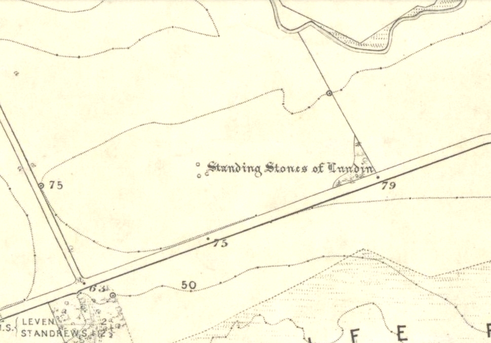
Lundin stones on 1855 OS-map
If you like your megaliths and you venture anywhere near here, make sure you come and visit these stones. They’ll blow you away! The only downfall we have is their location—stuck on the golf course; which, of course, means that meditating here is only possible between sunfall and sunrise (though I’ve usually found that’s the best time to be at stone circles anyway!), or perhaps in the pouring rain. Whichever is your preference, these stones need looking at!
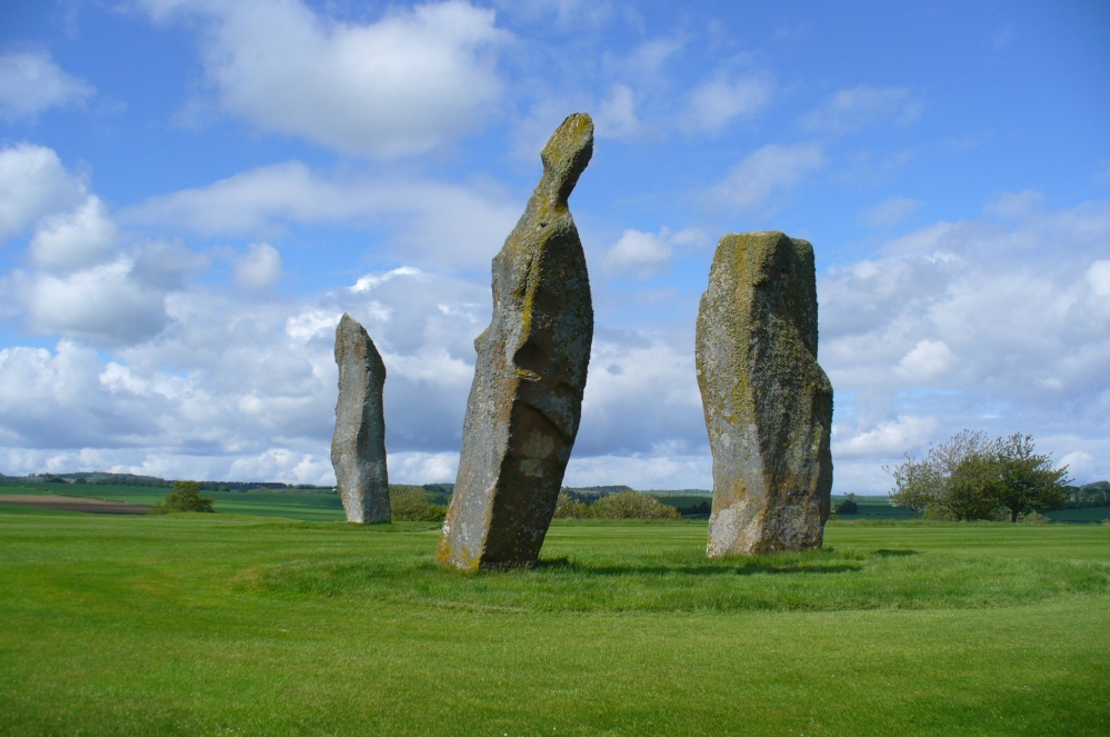
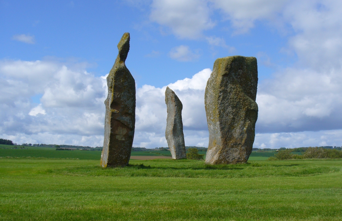
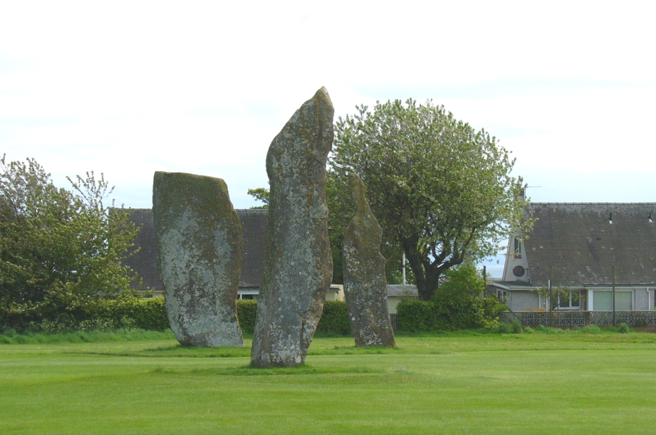
The size of them is the first thing that hits you. They belong more to the Avebury complex than sitting out on their geographical limb near the southern Fife coast. But then, that presupposes other stones of this size didn’t used to be here—and as far as I’m concerned, other giant megaliths and associated monuments must once have stood nearby. But much of the landscape hereby has been taken over by traditional agriculture and any earlier megalithic remains have seemingly been lost.
We know there were at least four stones here in the 18th century and that also, “ancient sepulchres are found near them” according to the New Statistical Account of 1837—but all remains of these burials seem to have been lost or destroyed. These facts are echoed in Leighton, Swan & Stewart’s (1840) gigantic survey. Thought by a variety of archaeological and historical sources to be the remains of a great stone circle “with a diameter of 54 feet”—it’s an assertion that I’m not too sure about myself. They are just as likely to be the remains of a great stone avenue, perhaps leading to a stone circle, long since gone, as much as any small circle of giant uprights.
In 1933, the Royal Commission survey described the size of these great red sandstone monoliths,
“Each of them has been packed at the base with a setting of small stones. Although it is not the highest, the one on the south-east, which stands with a slight inclination towards the north and the east, presents the most massive appearance. The girth at the base is 12 feet 8 inches, but measurements taken at 5 feet from the ground give the following dimensions: north face, 5 feet 2 inches; south face, 5 feet; east face, 1 foot 11 inches; west face, 2 feet 2 inches; girth, 14 feet 3 inches; and the stone becomes even wider as its height increases, until near the top where it again shrinks to a very slightly rounded extremity. The height is approximately 13 feet 6 inches. The surface is pitted by the action of the weather and shows greatest traces of decay on the east, where a crack has developed. The south stone is set with a decided inclination towards the south. It is of very irregular form with a girth at the base of 9 feet 4 inches, expanding to 10 feet at 5 feet higher up, and suddenly becoming gently attenuated at the top. The stone, which does not exhibit the same noticeable traces of weathering as the one first described, is approximately 17 feet high. The north stone, which is set with a slight inclination towards the west, appears to be still taller. It rises to a height estimated at 18 feet and has a sharply pointed top. It shows evidence of weathering at the northwest corner. Like the others, it increases in bulk from the base upwards to the middle of its height, the girth being 9 feet 6 inches at the base, and 10 feet 2 inches at 5 feet up.”
The trio, looking northThe 3 stones, looking south
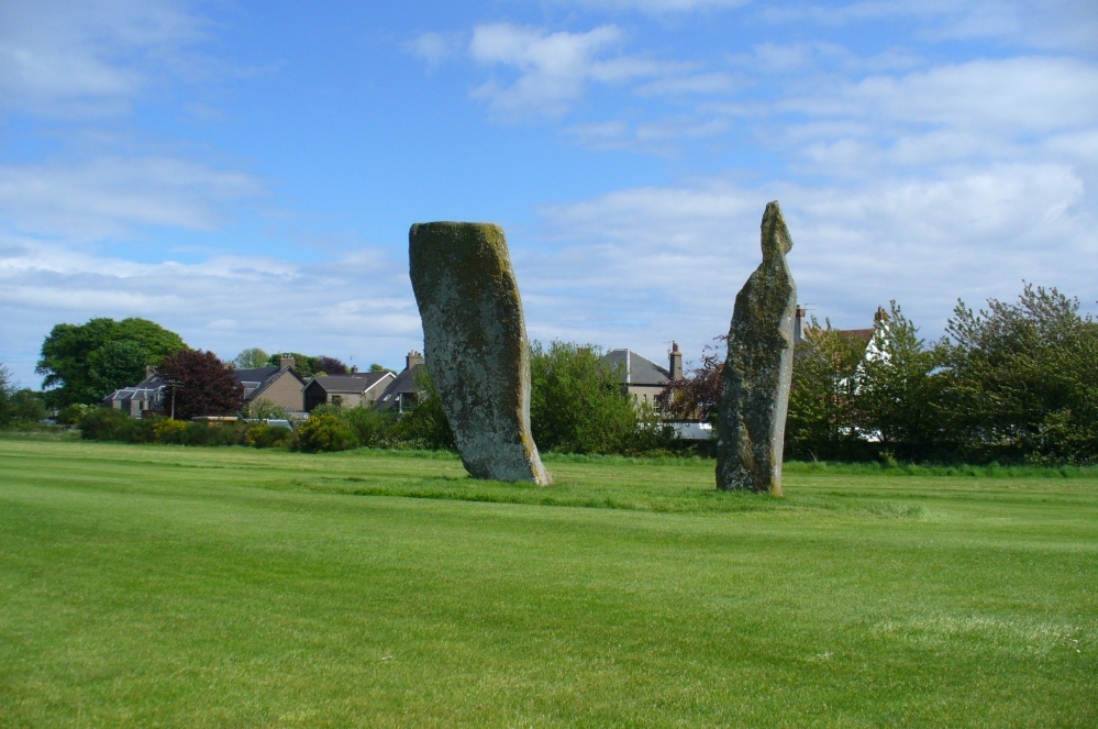
Big buggers by anyone’s estimation! Not mentioned here is the very distinct anthropomorphism, in one stone particularly—that at the southwest: a slim curvaceous body with neck and head at the top, frozen in stone no less. Surely this was intentional by the people who erected these giants? The southern pairing stand like man and wife, awaiting ceremony and customary servitude from us mere mortals. The single northern stone—whose partner was removed in the 19th century—has a similar slim stature and size, like its southwestern companion. Was its now dead partner a similar shape and stature like the southeastern stone? – another petrified pairing of man and woman? …Tis a curious feeling I have of this place…
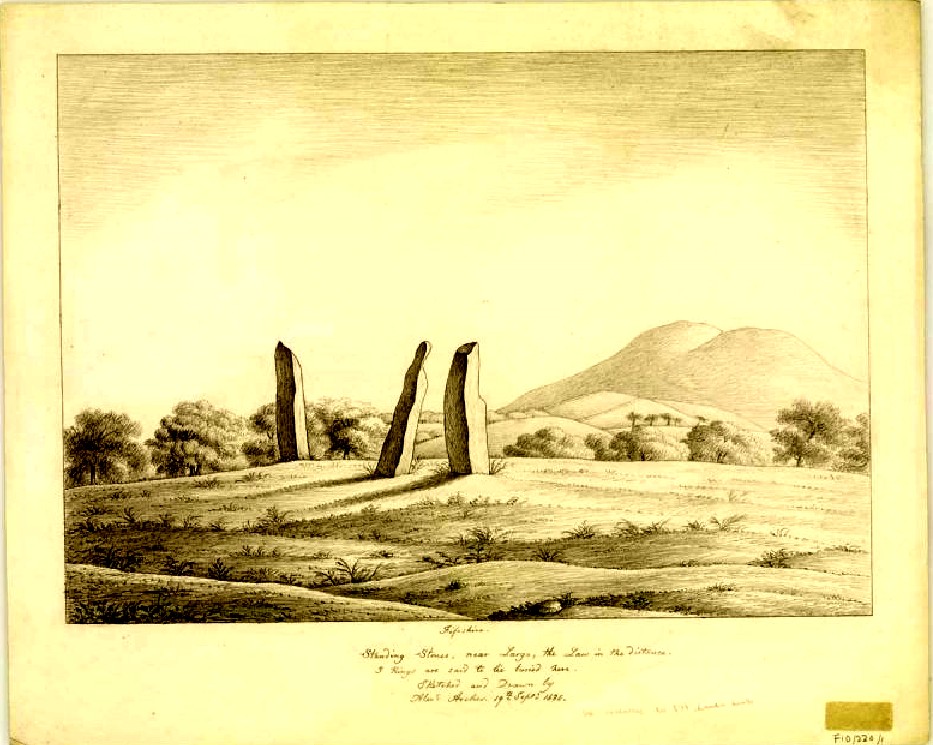
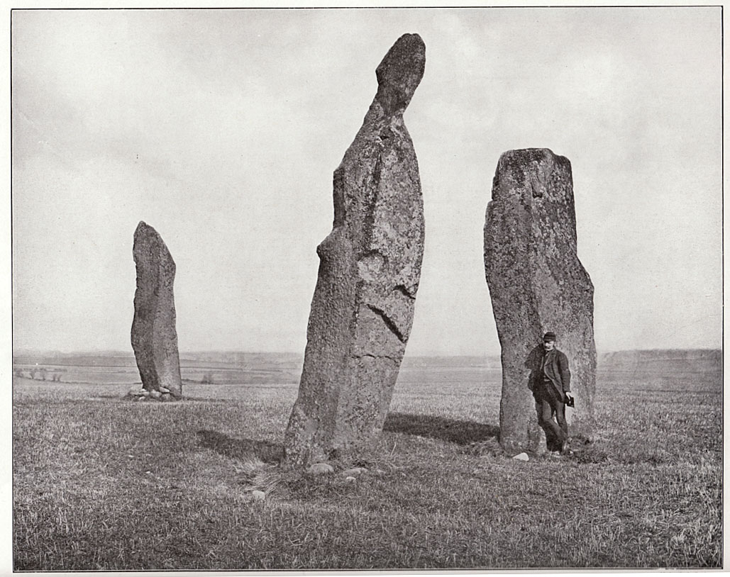
Early 19th century drawingPhoto of stones, c.1900
Our megalithic magus Aubrey Burl (1988) did note the “writhing pillars” of stone here, but ventured no further with it. He did tentatively suggest (and include in his work on the subject) that the Lundin stones were one of his “four poster” circles, but thought it “impossible to prove.” He did however revise the Royal Commission measurements on the respective standing stones, informing us that,
“The NNE is the tallest, 16ft 8ins (5.1m) high, the leaning SSW stone is 15ft (4.6m) high, but the lowest, at the SSE, is also the biggest, 13ft 8ins (4.2m) tall and 6ft 5ins (2m) thick.”
He also told that there were little cairns “about 18ins (46cm) high” around the base of each standing stone when he was here in the 1980s. These were not visible when we visited in May 2013.
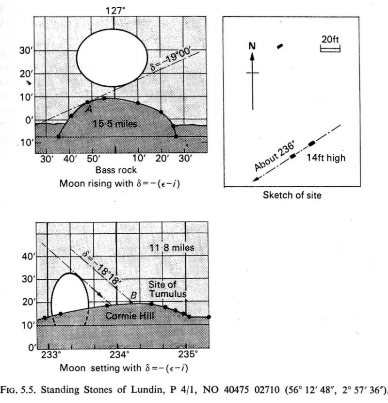
When the late great engineer and archaeoastronomer Alexander Thom (1971) came here, he found the layout of the stones to have astronomical meanings, telling:
“It was obviously an important site, so placed on flat ground that there was plenty of room for geometrical extrapolation. The alignment is seen to indicate the setting point of the Moon at the minor standstill. Trees and houses now block the view, but as the new large-scale OS maps are now available…it was possible to construct a reasonably accurate profile of Cormie Hill. In good seeing conditions, a large tumulus could have been seen on the Moon’s disc, and the tumulus shown on the Ordnance Survey happens to indicate the upper limb when the declination was -(ε-ι-Δ). When the Moon set on Cormie Hill it would rise on the Bass Rock, and we see how the stones were so placed that the lower limb just grazed the Rock when the declination was -(ε-ι).”
Thom’s lunar alignments
Thom reiterated his thoughts again in 1990, though pointed out that “the measurements should be checked” to see whether they were right. A few years earlier, Dr Douglas Heggie (1981) had done just such a thing and found the alignment seemed to be a poor one. And so it has turned out to be… Other megalithic sites however, have quite definite solar and lunar correlates in their architecture…but it seems our Lundin stones aren’t quite what Prof. Thom had hoped for.
Cup-mark & outer ring/s?
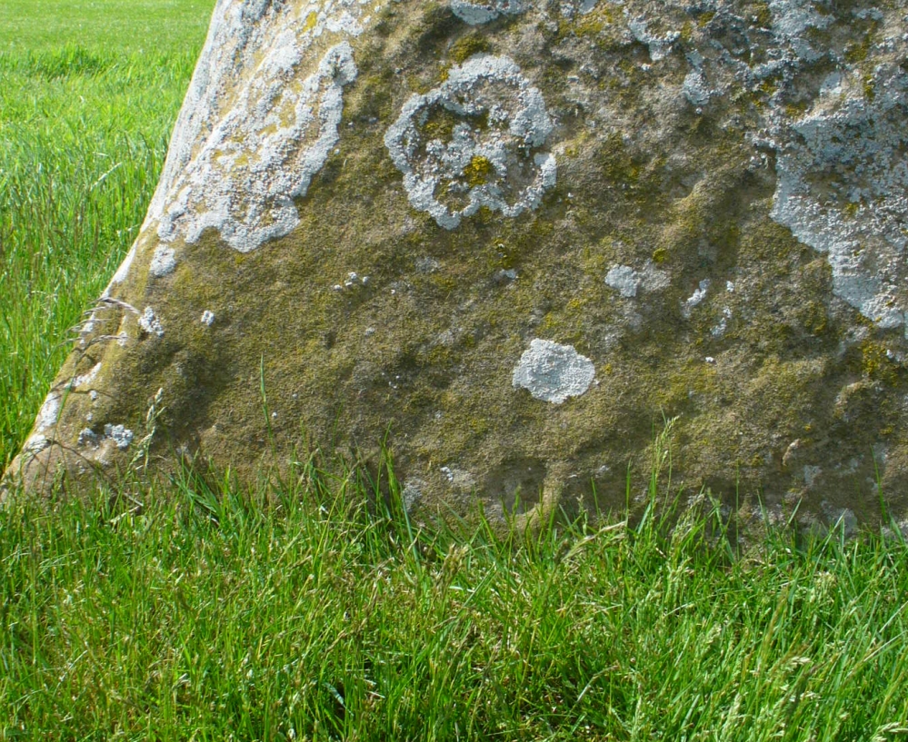
Along the eastern face of the “fattest” stone we see a number of large cup-markings, but these are all Nature’s handiwork. They were mentioned in Sir James Simpson’s (1867) early survey on the subject. However, we did see, near the base of the stone, just above ground level on its southern-face, a very distinct cup-marking with what may be the remains of a broken-ring around it. You can make it out on the photo here, but I wouldn’t stake my reputation on its legitimacy!
Folklore
Described in the Royal Commission (1933) report “as the burial stone of Danish chiefs,” this is a common tale found at other remaining megaliths along the Forth. The earliest account of this fable I’ve found is in the Edinburgh Magazine of November, 1785, where it was written:
“Various have been the conjectures as to the origin of the erection of the (stones); they are commonly known by the name of the Standing Stanes of Lundy, a seat belonging to a very old family of the name of Lundin, now to Sir William Erskine, near Largo in Fife.
“Tradition tells us, they were placed there in memory of that victory gained by Constantine II over Hubba, one of the generals of the Danish invaders, about the year 874. It is certain that battle was fought near this spot; but whether these were in memory of the action or not, I cannot determine: it is more than probable they were of a much older date.”
Legend also told that there was treasure at the stones, which was one of the reasons Daniel Wilson (1863) told the northwestern stone was broken and left only as a stump in 1792.
References:
Burl, Aubrey, Four Posters: Bronze Age Stone Circles of Western Europe, BAR 195: Oxford 1988.
Burl, Aubrey, The Stone Circles of Britain, Ireland and Brittany, Yale University Press 2000.
Burl, Aubrey, A Guide to the Stone Circles of Britain, Ireland and Brittany, Yale University Press 2005.
Heggie, Douglas C., Megalithic Science: Ancient Mathematics and Astronomy in Northwest Europe, Thames & Hudson: London 1981.
Leighton, J.M., Swan, J. & Stewart, J., History of the County of Fife – volume 3, John Swan: Glasgow 1840.
Royal Commission on the Ancient & Historical Monuments, Scotland, Inventory of Monuments and Constructions in the Counties of Fife, Kinross and Clackmannan, HMSO: Edinburgh 1933.
Ruggles, Clive, Astronomy in Prehistoric Britain and Ireland, Yale University Press 1999.
Simpkins, John Ewart, Examples of Printed Folk-lore Concerning Fife, with some Notes on Clackmannan and Kinross-shires, Sidgwick & Jackson: London 1914.
Simpson, James, Archaic Sculpturings of Cups, Circles, etc., Upon Stones and Rocks in Scotland, England and other Countries, Edmonston & Douglas: Edinburgh 1867.
Thom, Alexander, Megalithic Lunar Observatories, Oxford University Press 1971.
Thom, A. & A.S., & Burl, Aubrey, Stone Rows and Standing Stones – volume 2, BAR 560(ii): Oxford 1990.
Wilson, Daniel, The Archaeology and Prehistoric Annals of Scotland, Sutherland & Knox: Edinburgh 1863
Acknowledgements: With huge thanks to Paul Hornby, for the photos and the journey! Also a big thanks to Gill Rutter for help in clarifying “Getting there.”
From the railways station, walk to the dual carriageway (crossing the road) and walk on the A907 road to your left; cross the next road & walk round the corner, crossing the next road by the zebra crossing. OK, walk to your right, bearing immediately left down Devon Road, then just 20 yards on take the footpath up the side of the house on your left, and keep walking until you go into the trees. Then keep your eyes peeled for the fairy mound with a rock on top of it!
Archaeology & History
Overgrown cairn, looking NE
This is a large rounded, almost archetypal tumulus, sitting just a couple of minutes walk out of Alloa town centre, sandwiched between streets in the remaining copse of trees running east-west along Hawk Hill. Although the mound is of considerable size—with a large curious block of stone plonked on top—it hasn’t always been like that and has evidently been rebuilt sometime in the 20th century, for when the Royal Commission (1933) lads visited the site in July 1927, they reported only a bare trace of the old tomb, saying:
“The site of the cairn at Hawk Hill lies about 100 yds SSE of the lodge gate. The position is marked by a setting of young trees, but the ground has been cultivated and no definite outline of any structure can now be traced. A few loose stones of no great size, lying scattered about, are the only signs of a cairn.”
But the site is quite large, being more than 4 feet high and about 18 yards across, with a large flattened circular top. Nearby there was reported to have been another cairn, but this turned out to be little more than some recent debris.
Folklore
Local folklore tells that this monument is along a ley line that links it with the Hawk Hill Cross and destroyed stone circle east of here and the remains of a little-known standing on the outskirts of Alloa, to the west. I’ve not checked the precision of this alignment, but a quick scan of it looks pretty decent!
References:
Arabaolaza, Iraia, “Hawk Hill, Alloa,” in Discovery & Excavation in Scotland, New Series volume 10, 2009.
Royal Commission on the Ancient & Historical Monuments, Scotland, Inventory of Monuments and Constructions in the Counties of Fife, Kinross and Clackmannan, HMSO: Edinburgh 1933.
Royal Commission on the Ancient & Historical Monuments, Scotland, The Archaeological Sites and Monuments of Clackmannan District and Falkirk District, Society of Antiquaries of Scotland 1978.
From Threshfield, go up Skirethorns Lane for about 1/2 mile, where the lane takes a sharp right. Continue uphill for nearly 2 miles to a metal gate. Go through the gate into the fields on your left where you’ll see this pair of curious standing stones ahead of you (if you keep walking uphill in the same direction, you’ll reach the impressive Hammond Close enclosure above you).
Archaeology & History
There seem to be no references in either archaeology or geology texts about this site which, when you approach it and consider the prevalence of other prehistoric sites all round you, strongly suggests that they are either archetypal standing stones, or the remains of a collapsed cairn, with the surrounding mound removed. This is certainly the case at the Druid’s Altar or Bordley Circle visible a few hundred yards west of here, on the same grassland plain.
The stones alone, looking north
As you can see in the photos, the stones here are 4 feet tall and stand in isolation from the excess of neighbouring settlements and enclosures. A scatter of small stones—perhaps packing stones, perhaps the remains of cairn-spoil—is evident at the foot of the stones. It was initially thought that the uprights here could have been the remains of enclosure or settlement walling, as we find an excess of such remains on the hills here, but this isn’t the case. Other unrecorded prehistoric remains scatter this part of the countryside.
From Blackford on the north side of the A9, cross over and take the small B-road which quietly runs up and over Sheriffmuir towards Dunblane. After a mile, keep your eyes keen for the approaching woodland on your right-hand side; for in the field just before the woods, you’ll see a patch of grass near the corner of the field with a long stone poking out of it. That’s it!
Archaeology & History
It seems that very little has been written about this monolith in any of the archaeology texts, but it’s ascribed locally to be a fallen standing stone. The site’s described in Finlayson’s (2010) fine local megalith guide where he points out how it’s in line with other nearby standing stones at Gleneagles and the White Stone – and the line is damn close!
…and from another angle…
With a quartz vein running through it, the stone lays some thirteen feet long and was, at some time in the not-too-distant past, readied to be quarried, as evidenced by the chisel-marks cut into it, prior to the usual destruction. But this time, for some reason, someone must have come to the rescue and prevented its demise…thankfully…
The farmer annually cuts around the fallen stone, shaped like a long boat (hence the name), near the top corner of the field. It would have looked damn good when stood upright, standing about ten feet in height and visible for a good distance. But today it’s quite forlorn laid here, seemingly alone, in this quiet part of the country, and is probably only one of interest to hardcore megalithomaniacs amongst you!
References:
Finlayson, Andrew, The Stones of Strathearn, One Tree Island: Comrie 2010.
Along the A9 dual carriageway between Blackford and Auchterarder, take the A823 road south, up the Glen Eagles road as if you’re heading towards Pool of Muckhart and Dunfermline. Less than 100 yards up the road, turn immediately right and go past the standing stone of Gleneagles B for a coupla hundred yards or so, where there’s a left turn (down to Peterhead Farm). Stop here and look into the field in front of you. You can’t really miss it!
Archaeology & History
Gleneagles ‘A’, gazing west
This short standing stone, more than 3ft tall, has an elegance about it which megalith lovers alone will understand! Maybe it’s the setting; maybe the feel of the land; or maybe something else. I dunno… On my first visit to the site, Nature was wearing a grey overcast cloak, but the site and I didn’t seem to care; and although the view from here doesn’t have the same grandeur of Glen Eagles to view as its companion stone a few hundred yards to the east might have, there felt a greater welcoming at this smaller stone. Odd, considering this monolith had been knocked over and re-positioned by the farmer in the not-too-distant past. Anyway…less of this subjective nonsense of feelings from the landscape and megaliths! Utter drivel all of it!
The earliest measured account of the stone is to be found in Mr Hutchison’s (1893) essay, where he notes this and its companion close by, giving us the dimensions of this monolith:
“This (stone) is roughly columnar in shape, but wider at the base than above. Its height is 3ft above ground; circumference at base 6ft. 5in., diminishing to 4ft. 2in at the top. It is of metamorphic schist. The line of direction between these two gives a horizontal angle of 260°.”
Since that day, in the mass of archaeology essays that have been scribed, this smoothed upright gets only a minimal description. Charles Calder’s (1947) account is typical, saying simply that it is,
“Somewhat cylindrical in form with a girth of 7 feet at the base, it rises with a decided tilt towards the west to a height of 3 feet 10 inches above ground-level.”
The stone fares better in Andrew Finlayson’s (2010) fine local survey of megalithic ruins, where he points out that this and its compatriot stone Gleneagles B, are in an alignment with the fallen Boat Stone and the upright White Stone, a few miles to the southwest. This line works on 1:50,000 map, but when transferred to larger-scale surveys, the alignment misses each outlying site by 20-30 yards here and there.
Any remains of this once sacred site are now beneath the airport between Benson and Ewelme, a couple of miles northeast of Wallingford, on the eastern side of the River Thames. A great pity. It was one of the early cursus monuments discovered as a result of Major G.W. Allen’s many aerial surveys in southern England — as shown in his photo here — and subsequently described in Mr Leeds’ (1934) Antiquaries Journal article. A cluster of cursus monuments were built in this part of England in neolithic times, and Roy Loveday (2006) includes the Benson Cursus as an ingredient within the ‘sacred landscape’ region of what he calls “the Dorchester-on-Thames complex.” The Benson Cursus and surrounding regional monuments,
“in fact possesses features that would declare it as an inter-regional sanctuary if encountered in an historical setting; namely, intensity of monument construction, longevity of respect, addition of later exotic monuments with far-flung parallels, large numbers of burials, and placement in a landscape structured, partly at least, by other monuments. These elements recur from Delphi to Uppsala, and from Pachacarmaca to Mecca, at sites that Mircea Eliade (sic) has termed hierophanies — locations where the otherworld of gods and ancestors communicate with the living.”
Loveday’s 2006 planBenson Cursus plan (after Barclay & Lambrick)
It’s good to know that the correct paradigms are at last emerging from those archaeocentric minds!
In Mr Loveday’s (2006) plan of the cursus, no entrances could be found into the monument apart from a small section along the northeastern length of the structure (left). From its southernmost point, this giant monument runs along a SSW-NNE alignment — one echoed in other nearby cursuses — for 1192 yards (1090m) and is 71 yards (65m) across, covering 7.3 hectares in all. No internal structures were noted anywhere within the monument.
…to be continued…
References:
Barclay, A., Lambrick, G., Moore, J. & Robinson, M., Lines in the Landscape, OAU: Oxford 2003.
Benson, D. & Miles, D., The Upper Thames Valley: An Archaeological Survey of the River Gravels, Oxford Archaeology Unit 1974.
Eliade, Mircea, The Sacred and the Profane, Harcourt, Brace & World: New York 1959.
Leeds, E.T., “Rectangular Enclosures of the Bronze Age in the Upper Thames Valley, in Antiquaries Journal, 14:4, 1934.
Loveday, Roy, Inscribed Across the Landscape, Tempus: Stroud 2006.
Of at least 26 prehistoric barrows or tumuli in close proximity on the grasslands immediately west of the Badbury hillfort, this particular ‘Badbury Barrow’ as it’s generally called, was the most intriguing of the bunch. Intriguing as it was found to possess a very rare carved stone near its centre, and had the elements of the dead laid out in a quite fascinating manner, with a large inner wall that surrounded the dead. Grinsell (1959) posited that this site may be the same one described on the 1826 Greenwood Map of the region as the ‘Straw Barrow’ – in which case I’d love to know if there are earlier place-name references to the site and see what its name is thought to mean. (Mills’ PNs Dorset, 2, could be helpful – though it could be just ‘straw’!) However, the Straw Barrow is some distance to the west of here.
The first lengthy description of the site was done very soon after the near destruction of the place in 1845. A local man called John Austen visited and described the old tumulus in some considerable detail, and I make no apologies for adding his complete description of the barrow, as he found it, just before the land-owner levelled the place. He wrote:
“On Nov. 1, 1845, I accidentally ascertained that a barrow situated about five miles from Wimborne, Dorset, upon the road leading to Blandford, and in the immediate neighbourhood of Badbury camp, was in progress of being levelled. The circumstance which chiefly attracted my notice was the vast quantities of large sandstones and flints which had been taken from it. Unfortunately nearly two-thirds of the tumulus were already removed. From the remainder, however, I have obtained a tolerably accurate idea of its interior arrangement, which, with perhaps the exception of the ‘Deverill barrow’, opened by W. Miles, Esq., in 1825, is more highly interesting than any yet examined. The labourer employed could give me but little information respecting the part already destroyed, further than that he had thrown up many pieces of pottery, and found one urn in a perfect state, but in removal he had broken it; sufficient however remained to enable me to ascertain its form and dimensions. It measured 8 inches in height, 6¾ inches at the mouth, and at the bottom 3½ inches. The colour of the outer side was more red than is usual, and within it had a black hard ash adhering to the side, It was inverted, and contained only a few white ashes. It was ornamented with lines of from nine to fourteen fine pricked dots, as if made with a portion of a small tooth comb. Such an instrument was discovered a few years since by some workmen, whilst lowering a hill midway betwixt Badbury camp and the village of Shapwicke, having at one end a small circular hole, and at the other eight short teeth like those of a comb. It was four inches long and one inch wide, and was part of the rib of a deer…
“The barrow was circular, measuring about eighty yards in circumference, the diameter sixty-two feet, and the height nine feet; it had however been considerably reduced by the plough. Upon clearing a section across the centre, the following formation presented itself. The outside circle or foot of the barrow was of chalk, occupying a space of fifteen feet towards the centre. There was then a wall extending completely round, and enclosing an area of about thirty feet in diameter, composed of large masses of sandstone brought from some part of the heath, probably from Lytchett, a distance of not less than five miles, and across the river Stour. These stones were well packed together as in the foundations of a building, and the interstices tightly filled with flints. Within this wall, for the space of three or four feet, was a bed of flints, without any mixture of earth or chalk, packed together from the floor to the surface of the barrow, having only a few inches of earth above. The remainder of the interior was occupied by large sandstones, serving to protect the various interments.
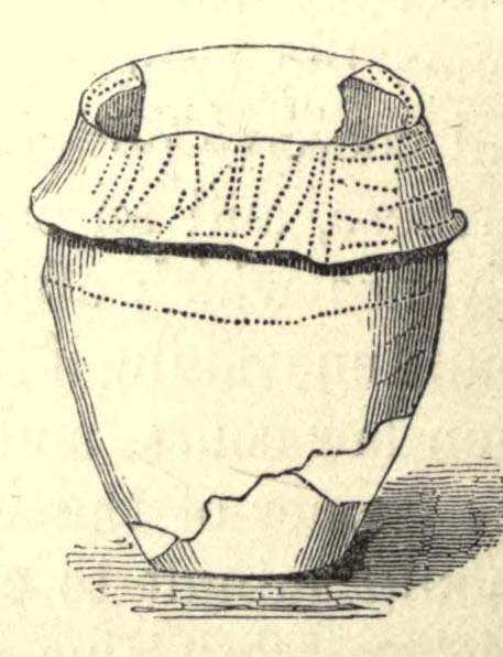
Urn found in one cist
“About the centre I found six deposits. The most northern of these was the skeleton of a young child, by the side of which, proceeding west, there was a cist containing a deposit of ashes and burnt bones; and near it another, rather above the floor, containing burnt wood. Immediately beneath this was a cist containing an urn, placed with its mouth downwards, and filled with burnt bones, which were perfectly dry and white. It was without any ornament, and measured in height ten and a quarter inches; the diameter at the mouth, which turned outwards, was eight and three-quarter inches, and at the bottom four inches. The other cists contained burnt bones and ashes. Sandstones had been placed over them, but were removed without my having an opportunity of ascertaining their position. A short distance south of these deposits there was a cist containing the bones and skull of a young child, over which had been placed a flat sandstone, and about a foot from it appeared a deposit of small bones, occupying a space of only two feet ; these were apparently the remains of a woman. Immediately above was a row of sandstones, resting, as was usual throughout the barrow, upon a thin layer of burnt wood. At this spot the barrow appeared to have been opened after its final formation, as if for the purpose of a subsequent interment, and filled up, not with the earth of which the remainder was formed, but with loose chalk, there being no stones or flints above those which lay immediately upon the deposit. At the extreme south of these cists was a large sandstone, three feet in diameter by sixteen inches in thickness, placed edgeways. The above-mentioned cists were circular.
Upright urn outside of cists
“A few inches west of the cist described as containing an urn, was the lower half of another, measuring in diameter five and a half inches, inverted, and placed upon the floor of the barrow, without any protection, merely surrounded by a thin layer of ashes and then the solid earth. It was filled with ashes and burnt bones, and rested upon the parts of a broken skull. Near this was an urn, also unprotected, and consequently much injured by the spade. It was placed upright, and measured in diameter nine and a half inches, by about ten inches in height. In form it resembled the urn first described, marked with impressed dots, but it was without any ornament. A short distance from these was a deposit of burnt wood at the west side of a large flat stone, placed edgeways, which measured three feet four inches by two feet ten inches, and thirteen inches in thickness. From its appearance it would seem that the fire had been lighted by its side. Immediately beneath the edge of this cist, and resting upon the chalk, was a small urn inverted, and by its side some small human bones. It was wholly unprotected, and unfortunately destroyed. South-east of this was a cist sixteen by twelve inches in diameter, and eighteen inches in depth, containing ashes and a few burnt bones, with a large-sized human tooth. Close to the edge of this cist, upon its western side, was placed in an upright position, a large stone measuring in diameter three by two and a half feet; and leaning against it another of still larger dimensions, inclining towards the north. This measured six and a half by four feet, and fifteen inches in thickness. About three feet further east were two large stones set edgeways, and meeting at their tops. Beneath them was the skeleton of a small child with the legs drawn up, lying from west to east. At the north-west side of the barrow, about five feet within the wall, was a cist cut in the solid chalk, measuring sixteen inches in diameter by sixteen in depth; it contained an urn inverted, and filled with burnt bones. Though carefully bandaged, it fell to pieces upon removal, being of more brittle material than any previously discovered. The clay of which it is formed is mixed with a quantity of very small white particles, having the appearance of pounded quartz. It measured in height nine inches by nine and a half in diameter, and is ornamented by six rows of circular impressions made with the end of a round stick or bone of a quarter of an inch in diameter. The cist was filled up with ashes.
Small cup-like urn
“A few inches from this was a cist differing in form, being wider at the top than beneath, in diameter eighteen inches by eighteen in depth; a flat stone was placed over it. It contained the skeleton of a young child, laid across, with the legs bent downwards. Lying close to the ribs was a small elegantly-shaped urn, measuring four inches in height by four in diameter, and made of rather a dark clay. It is ornamented with a row of small circular impressions, similar to those mentioned in the last instance, close to the lip, which turns rather out: beneath is a row of perpendicular scratches, and then two rows of chevrons, also perpendicular. At the feet of the skeleton was a peculiarly small cup, measuring in height one and a half inches by two and a quarter in diameter. It is ornamented with two rows of pricked holes near the top, beneath which is a row of impressions, made probably with an instrument of flat bone, three-eighths of an inch in width, slightly grooved across the end. The same pattern is at the bottom and upon the rim.
Another cup-like vessel
“Near this, towards the south-west, was a deposit of burnt wood, situated above the floor of the barrow, and immediately beneath it were two cists. In one of these, which measured two feet in diameter by one and a half in depth, were a few unburnt bones and several pieces of broken pottery, with a small cup, ornamented with three rows of the zigzag pattern, betwixt each of which, as well as upon the edge, is a row of pricked holes, and at the bottom a row of scratches. It measured in height two and a half inches by three in diameter, and had two small handles pierced horizontally: there appeared to have been originally four. In the other, which measured two feet in diameter by one in depth, were a few unburnt bones and a small urn placed with the mouth upwards, measuring four and three-quarter inches in height by the same in diameter. The lip, which turned very much out, is ornamented with a row of scratches, both within and upon its edge, a similar row also passes round near its centre. Close upon the edge of this cist was another urn of similar dimensions, inverted, and embedded in the solid earth without any protection. It is of much ruder workmanship than any of the others, and wholly unornamented, measuring five inches in height by five in diameter. Both these urns inclined equally towards the south-east. These last cists were partly, if not quite, surrounded by large sandstones set edgeways, and smaller ones built upon them, forming as it would seem a dome over the interments, filled with earth, and reaching to the surface of the barrow, where these stones have been occasionally ploughed out. From this circumstance, as well as the general appearance of the excavation, added to the description given by the labourer of the other part of the barrow, I am induced to suspect such to have been the case throughout… I found many pieces of broken pottery, and a part of a highly-ornamented urn. There was a total absence of any kind of arms or ornaments. The labourer however shewed me a round piece of thin brass, which he had found amongst the flints within the wall, measuring an inch and five-eighths in diameter. It had two minute holes near the circumference. It was probably attached to some part of the dress as an ornament. Teeth of horses and sheep were of frequent occurrence; I also found some large vertebrae and the tusk of a boar. Upon one of the large stones was a quantity of a white substance like cement, of so hard a nature that it was with difficulty I could break off a portion with an iron bar.
“If I offered a conjecture upon its formation, I should say that the wall, and foot of the barrow, which is of chalk, were first made, and the area kept as a family burying-place. The interments, as above described, were placed at different intervals of time, covered with earth (not chalk) or flints, and protected by stones. And over the whole, at a later period, the barrow itself was probably formed. My reason for this opinion is, first, that all these deposits, including, as they do, the skeletons of three or four infants, could scarcely have been made at the same time. And in the second place there was not the slightest appearance (with one exception) of displacement of the stones or flints in any way. As these circumstances then would suggest that the interments were formed at various periods, so the general appearance leaves no doubt as to the superstructure of flints, and surface or form of the barrow itself having been made at the same time and not piecemeal.
“I have met with no instance of a British barrow containing any appearance of a wall having surrounded the interments. Pausanias, in speaking of a monument of Auge, the daughter of Aleus king of Arcadia, in Pergamus, which is above the river Caicus, says, ‘ this tomb is a heap of earth surrounded with a wall of stone.’ And in the Saxon poem, ‘Beowulf,’ mention is made of a similar wall as surrounding the tomb of a warrior.”
One of the stones inside here was later found to possess “carvings of five cupmarks, two bronze daggers and two flat, triangular axes of early Breton type,” (Burl 1987) which Austen didn’t seem to notice at the time of his investigation. A profile of the Badbury Barrow carving can be found here.
Folklore
In Peter Knight’s (1996) survey of megalithic sites around Dorset, he includes the Badbury Barrow along a ley line that begins at the tumulus just below (south) Buzbury Rings and then travels ESE for about 5 miles until ending at another tumulus at ST 006 996.
References:
Austen, John H., “Archaeological Intelligence,” in Archaeological Journal, volume 3, 1846.
Burl, Aubrey, The Stonehenge People, Guild: London 1987.
Grinsell, Leslie V., Dorset Barrows, Dorset Natural History & Archaeological Society 1959.
Knight, Peter, Ancient Stones of Dorset, Power: Ferndown 1996.
Piggott, Stuart, “The Badbury Barrow, Dorset, and its Carved Stone,” in The Antiquaries, volume 19, 1939.
Royal Commission on Historical Monuments, England, An Inventory of the Historical Monuments in the County of Dorset – Volume 5: East Dorset, HMSO: London 1975.
Stone, J.F.S., Wessex Before the Celts, Thames & Hudson: London 1958.
Warne, Charles, The Celtic Tumuli of Dorset, John Russell Smith: London 1866.
A couple of miles west of the Hutton Moor henge we find the faint remans of another large prehistoric ritual site, soon to fade from existence. Although the local farmer was aware of the existence of this ‘earth circle’ in his fields in the 1940s, the place wasn’t officially catalogued until Prof. J.K. St. Joseph noticed it following an aerial survey of the region in 1951 (from whence the aerial photo comes). Today sadly, much of the site has succumbed to the ravages of excessive agricultural activity and is all but destroyed. Faint traces of it can be seen at ground level when the crops are down, but most of it’s gone. Even when first discovered, the remains were sparse, as the photo (below) shows.
Early aerial photo of Nunwick hengeMr Dymond’s early ground- plan (from YAJ, 1963)
Neolithic in origin, the site was excavated in 1961 by D.P. Dymond who explored a portion of the bank and ditch and stripped a small internal section. His findings showed it to be structurally similar to the other henges in the area and of considerable size. Measuring 690 feet across, the henge spread across two fields and was bisected by a hedge and farm track. When Dymond first explored the henge he reported how the surrounding bank was between 1-3 feet high and had been spread to a width of 120 feet; the ditch was just a couple of feet deep; and the original ‘entrances’ north and south of the ring were still just visible as “slight depressions in the bank.”
The Nunwick henge was classed as a Class II henge (after Atkinson). Five feet smaller than the Thornborough (south) Henge, its entrances are close to north-south. The River Ure is less than half-a-mile from the site and the presence of other streams close by further emphasizes water as a potentially relevant ingredient. This element seems to have had some factor in the structure of the henge as there were many water-worn stones found in the embankment, which probably came from the nearby river. However, like many henges, very few remains were discovered upon excavation here, as Mr Dymond’s (1963) account tells:
“The 1961 Excavation was restricted to a single long section through the northwest side of the circle, to examine the structural details of the bank and ditch, and to confirm the apparent absence of an outer ditch.
“A small area, 22ft square, was stripped inside the ditch to test for pits or postholes, but nothing was found in the sandy silt which covers the gravel deposits. Air-photographs gave no indication of a former presence of standing features within the enclosure.
“The ditch was found to be 45ft wide and 5ft 10in deep, with a wide, shallow profile. Allowing for the destruction by ploughing of the upper edges of the ditch, the orignal dimensions of the ditch were undoubtedly greater. The edges of the ditch were not easy to see in excavation, as the fill was similar to the natural gravel subsoil and some slumping had occurred on the loose gravel faces. The ditch had apparently silted slowly with material washed in from both sides. At an early stage in the silting, when the accumulation was about 1ft, there had been occupation in a limited area, revealed by a circular patch of burnt material, 10ft in diameter, which contained many split pot-boilers reddened by fire.
“Between the ditch and bank there was originally a berm of 30ft. On the surface, this is not visible as the bank shades imperceptibly into the ditch. The bank was originally about 60ft wide, but is now considerably spread on both sides. In the 1961 section the bank survived only 18in high; this was sufficient, however, to show clear traces of tip-lines and the interleaving of loads. The lowest two inches of bank material consist partly of turf… Under the bank, the original turf-line was visible as a purple-black line, 1-3in thick, with traces of a weakly developed iron-pan. In the original composition on the bank there were many water-worn stones (3-9in across), now in the outer spread and in the bottom of the ditch; on the northern side of the circle where the bank is best preserved there are large quantities of these stones on the plough soil. Quarried from the bottom of the ditch, where the aggregate of the gravels was much larger, these stones were probably on the top of the bank.
“Two square were dug outside the bank, on the line of the section to text for an outer ditch. This confirmed the evidence of air-photographs that no such ditch existed. Of the six henges in the Ripon area, Nunwick is therefore the only one without two ditches.
“No dating evidence was found in the 1961 excavation. Three worked flints however, were picked up from the plough soil of the southwestern field near the henge. They consist of two waste flakes and a small flake scraper of opaque brown flint.”
Archaeologists and ley hunters alike have described how the Nunwick Henge aligns with the three prominent Thornborough Henges to the north. Significant…?
References:
Dymond, D.P., “The Henge Monument at Nunwick, near Ripon – 1961 Excavation,” in Yorkshire Archaeological Journal, part 161 (volume 41), 1963.
Wainwright, Geoffrey J., “A Review of Henge Monuments in the Light of Recent Research,” in Proceedings of the Prehistoric Society, volume 35, 1969.
Another stone for the rock art purists amongst us: a singular cup-marking near the edge of the rock. Although the photo here seems to show three cup-markings close to each other, only one of the three is in fact real. The other two are simple geological creations. But this fact seemed to go over the heads of some English Heritage archaeologists who reported to Boughey & Vickerman (2003) that this was a stone “with three cup markings” on it. I’m not sure who trains EH rock-art enthusiasts, but they seem to have a tendency to mistake natural features with artificial cup-markings and their evaluations should be treated with considerable caution (you’ve gotta wonder who the students are that are teaching them).
The rock itself is found in close association with other prehistoric remains and may have been a part of enclosure walling. Very close by are numerous well-preserved settlement remains, cairns and other cup-and-ring stones.
References:
Boughey, Keith & Vickerman, E.A., Prehistoric Rock Art of the West Riding, WYAS: Wakefield 2003.