You can’t really miss this. Roughly halfway along the B1383 London Road between Littlebury and Wendens Ambo, just above Chestnut Avenue, a dirttrack on the west-side of the road takes you up and onto the wooded hillside. Where the track splits in two, head straightforward up and into the trees until it opens into the clearing. You’re there!
Archaeology & History
This great monument had already been described several times before the Domesday Book had even been thought about! Indeed, it seems that the town itself gets its name from the hillfort! (Reaney 1935) Nowadays the place is just about overgrown and covered in woodland. You cna make out various undulations where parts of the ditches are apparent, but it could do with a clean-out. Thought to be Iron Age, Nick Thomas (1977) described the site as,
“Oval in plan, this fort follows the contour of the hill it encloses, protecting about 16½ acres… the defences consist of a bank, ditch and counterscarp bank, of which only the ditch is well-preserved.”
References:
Reaney, Paul, The Place-Names of Essex, Cambridge University Press 1935.
Thomas, Nicholas, Guide to Prehistoric England, Batsford: London 1977.
Follow the same directions as to find the Lunar Stone, Spotted Stone, etc. Go thru East Morton village up the steep moorland road, east, and where the road levels out there’s a right turn and a trackway on your left which leads onto the moor. Go ½-mile up this track till you hit a moorland ‘footpath’ signpost. Stop here and walk due west (left) for a coupla hundred yards. If the heather’s grown back you aint much chance of finding owt – but if there’s only low growth, amble about zigzagging – and keep your eyes peeled!
Archaeology & History
Section of cairn rubble & walling
Although there’s been no written record of the Stanbury Hill remains until very recently, it seems quite probable that Mr Stuart Feather would have come across at least parts of these remains when he uncovered the rock-art in the same vicinity, but he never made public his finds. He was a diligent researcher and finder of cup-and-ring stones, nose to the ground sorta chap, and it would be odd for him to miss the other remains on this hill. For as we now know, there are undeniable evidences of considerable neolithic and/or Bronze Age walling scattered along (mainly) the southern side of Stanbury Hill, running mainly along an east-west axis, but there are also examples of the walling running roughly north-south. In at least one position near the western end of the ridge, halfway down the south-facing slope, is what seems to be the unmistakable trace of an enclosed hearth. At the time of writing a series of archaeological digs are, slowly, being done hereabouts, so it will be good to read their final evaluations.
Very close to some parts of the walling we find the remains of old cairns, and at least one cup-and-ring stone has been carved along the axis of one line of walling (it reminded me very much of the Bronze Age settlement remains found at Snowden Moor, over the northerly horizon, in the Washburn Valley). Several other previously unreported cup-marked stones have also been found here (we’ll highlight them on TNA in the coming weeks).
Upon first impression the remains found upon and around Stanbury Hill seem more related to mortuary practices than what we’d call ‘domestic’ living practices, as the prevelance of carvings and cairns indicates. But we’ve gotta be cautious here, as in many sites the dead were kept with the living; and as we find in many traditional or aboriginal cultures, the land of spirits and that of the living are much more closely allied than in our profane ‘Western’ paradigm.
Dead easy. Take the road up through Grassington village, up Moor Lane, onto the grassy tops towards Yarnbury. As the road levels out, and before you reach the tree-border of Yarnbury house, there’s a field on your left-hand side, opposite the one where the Yarnbury Henge lives. If y’ go in there to check out this walling, shut the effing gate!
Archaeology & History
Section of walling, Yarnbury
It appears that there’s little information on the remains of what seems to be some Iron Age walling a few hundred yards away, northwest of the little Yarnbury ‘henge’ monument. Mikki Potts noticed it first of all, in one of the Northern Antiquarian ambles here t’other day. The walling is quite distinct and typical of finds elsewhere, particularly the excessive Iron Age and Bronze Age walling remains less than a mile west of here, down the slopes near Grasssington. At least two lines of walling are clearly apparent, running roughly northeast-southwest. Another section runs off towards the extant walling back towards the road. But more intriguing (for me anyway!), is what seems to be the remains of an old circle less than 100 yards north, on the other side of the footpath in the same field.
We didn’t spend too much time here and so another visit is obviously needed for further exploratory wanderings, but there appear to be further remains. Although much of the terrain hereabouts is scattered with an excess of medieval archaeological relics — including some disused shafts at the very top of this same field — this section of walling has all the hallmarks of a much earlier period. (sadly, a lot of the early mine-workings up here has destroyed a considerable amount our earlier prehistoric heritage). As one local told us a a coupla weeks back, “There’s loadsa stuff up here which aint in the record books!”
Certainly seems like it!
(In the event that these remains turn out to be of a later period, this profile entry will be removed from TNA.)
Various ways to get here. From Worsthorne village, go east, up past the church, uphill following the dead straight path. After about 600 yards there’s a crossing in the footpath: go left here and walk another coupla hundred yards, over 2 walls, and after you’ve past the second wall you’ll notice the earthworks in the ground to your right. That’s it!
Archaeology & History
There’s nowt much to see here to be honest. It was included in Walter Bennett’s (1946) survey of ROMAN remains (oh dear) in the region — and his archaeological description of this place certainly seems to imply it was those doods (the Romans) who built this structure and not our neolithic ancestors. He wrote:
“Ringstones is a rectangular enclosure 50 yards square, surrounded by a mound or rampart 2 yards wide and one yard high, and an outer ditch two yards wide. Sepereated from the main enclosure by the ditch on the southeast side is another enclosure 18 yards square. Excavations made in 1925 gave the following information: a gateway, seven yards wide, was paved with boulder stones regularly laid on a gravel foundation, and on the south side of the gateway flat stones were sunk below the general floor level to act as a drain; a regular course of large stones flanked the gateway entrance on either side, and a foundation or irregular boulder stones was laid outside the gateway between the rampart and the ditch: inside the enclosure and 9 inches below the present grass surface., a floor had been made of gravel in some places and of flat stones or cobbles in others; the rampart was of earth and stones; a well-constructed road, 7 feet wide, ran from the earthwork in the direction of Bottin Farm, wich is situated on the Worsthorne-Roggerham road.”
There used to be a rough circle of stones on top of the site (probably giving the place its name), but these were apparently from the old remains of a lime-kiln from the 16th or 17th century — not prehistory. There is, therefore, a case that this site may not be prehistoric as archaeologists have classed it — and if the ground-plan above is anything to go by, you’d have to say it looks less than promising. More diggings are needed!
From Ford village, take the track that goes uphill (west) running near the edge of the forest-line. Keep going until you hit the top of the forest and the large rocky hill above you (on your right) is where you need to be heading. The rise to your left is Dun Chonallaich. Walk around the bottom of the hill until you get to the other side (you should be 100 yards or more above the tree-line) where you’ll notice a ‘pass’ running west, with a rocky knoll above you on your right. That’s it!
Archaeology & History
Thought to date from the Iron Age, the remains here cover an area 15 yards by about 25 yards. Remains of walling around the edge of the summit nearly a yard wide in places define quite clearly where the ‘fort’ was centred. The entrance to the site was found on the northwestern side. In more recent times however, animal pens have intruded on the remains here and the archaeological remnants are much denuded.
Folklore
Samhain fires were lit on the larger ridge above this ruined fort until recent years, as some old local folk will tell you. These Halloween fires (done to celebrate the old New Year) were stopped a short time after the new ‘owner’ of the Auchinellan Estate (on whose land Dun Dubh is found) took exception to them and, for all intent and purpose, deemed them a fire hazard! The lady in question who inherited the Estate was in fact a devout christian who took exception to the local “pagan” goings-on, contrary to the beliefs of the previous Estate owner, who not only allowed such old events, but played a part in them. Local folk hereabouts, not surprisingly, aint too keen on their part-time dictatorial christian neighbour.
The fires up here were also related to the linear cemetery at Kilmartin. Here the giant tombs all line up & point to Dun Chonallaich, behind which hides the more flattened top of Dun Dubh. When the Halloween fires were lit on top of this, the glow from behind the great pyramid of Chonallaich all the way down the Valley of the Kings, was spectacular! One wonders just how long the local people had been doing this. Quite a long time I imagine….
References:
Royal Commission on the Ancient & Historical Monuments, Scotland, Argyll – volume 6, HMSO: Edinburgh 1988.
From the Askwith Moor dusty parking spot, walk up the road for 160 yards where, on each side of the road, you’ll see a straight line running across the moors. On the left-side (west) walk onto the moor for 50-60 yards along this line, then dead straight west into the heather for another 50-60 yards and look around. It’s hard to see if the heather’s grown.
Archaeology & History
Found by Richard Stroud on July 20, 2004, this single hut circle is in faint evidence. About twenty feet across with a section of the low walling either missing, or more probably buried in the peat. Although no other hut-circles were immediately visible, this was probably because of the excessive heather-growth. I have little doubt that others will be close to this one, as the area is littered with prehistoric sites. The petroglyph catalogued as Askwith Moor 529 is very close to this hut circle.
Follow the directions to reach the giant Haystack Rock, then follow the footpath west along the moor-edge, round where it bends keeping along the edge of the stream (Backstone Beck) below. A couple of hundred yards after the bend, right by the side of the path. You’ll see it! (if you hit the clearly defined ‘enclosure’ walling, you’ve gone too far)
Archaeology & History
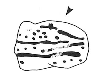
No — not the Rosetta Stone; but it is a lovely carved rock this one. Best seen (as usual) when the rock’s wet and the sun’s heading for (or just emerged from) the horizon — but much of this image is visible even when She’s cloudy.
Close-up of ‘rosette’ design & and other CnRsThe Rosette Stone carving
First mentioned in literary terms (surprisingly) by M.J. Walker (1956), in a short write-up following one of the Bradford Archaeology Group’s moorland walks up here. Nearly six-feet along its longest axis, there are more than 30 cup-marks on this stone, at least three with rings; plus a variety of lines linking some cups to others. At its northern tip is the lovely little ‘rosette’ design, as archaeologists have called it. Others have seen this part of the design as a solar image; a flower; the Pleiades; a ring — take your pick! It is a lovely carving though (if you’re a sad person like me, who’s into these sorta things!). What relevance – if any – it may have had to the ‘enclosure’ within whose edges it sits, is anyone’s guess!
Excavations done close by (focusing mainly on the prehistoric ‘enclosure’ within whose domain this and other carvings occur) uncovered remains of old grooved ware pottery and the remains of flints. (Edwards & Bradley 1999)
The one thing we realise from looking at this design is the difference seen between the ‘accurate’ illustration drawn by archaeologists, and the flesh and blood of the stone itself, in situ. The living rock has much greater form and expression than anything which our desire for accuracy possesses. This aint knocking any attempt to portray the cups, rings and lines on paper correctly to show what the design originally looked like; merely that there’s a world of difference between the experiential vision of the carving and that done with graphic accuracy. But we all know that anyway – so please forgive my little sojourn into speaking the bleedin’ obvious!
References:
Boughey, Keith & Vickerman, E.A., Prehistoric Rock Art of the West Riding, WYAS 2003.
Edwards, Gavin & Bradley, Richard, ‘Rock Carvings and Neolithic Artefacts on Ilkley Moor, West Yorkshire,’ in Grooved Ware in Britain and Ireland (edited by Cleal, R. & MacSween, A.), Oxbow: Oxford 1999.
Hedges, John (ed.), The Carved Rocks on Rombald’s Moor, WYMCC: Wakefield 1986.
Walker, M.J., ‘Ilkley Boulders Tour,’ in Bradford’s Cartwright Hall Archaeology Group Bulletin, 2, 1956.
Pretty easy to find. Follow directions to reach the great cup-and-ring marked Haystack Rock, then follow the footpath west and drop down the slope, crossing the stream of the Backstone Beck below you, the up the steepish slope and turn sharp left when you hit the footpath before the top of this slope. Walk onto the moor! You’ll walk right past the cup-and-ring marked ‘carving 283’ on this path, then the ruinous Backstone Circle a bit further along (50 yds to your right), but keep walking for another 100 yards until you see a large boulder a few yeards to the left of the footpath. That’s it!
Archaeology & History
I first came across this as a kid, sometime in my early to mid-teens, pottering about, looking at any old rock that caught my eye. And this one isn’t hard to miss really. One of the best memories I’ve got of this stone was when a bunch of us came walkabout up here, sometime in the autumn, when the heavens poured all day long to saturation-point — even for those in all their protective gear, such good as it was in the late ’80s to early ’90s. There started out a fair bunch of us—between 20-30 folk—with numbers dwindling sharply when we reached the Apostles. But this stone was visited way before that! Along with Bob Trubshaw, Graeme Chappell, Kaledon Naddair, Edna Whelan and a troop of other mad-folk, we stopped for a while to consider this old rock, with only three cups really visible that day. The others (those cited by the archaeo’s) weren’t picked out, as I remember. But She was pissing-it-down and the wind was really giving-it-some, so we didn’t stop here for long! We all agreed though: it was a nice, worn cup-marked stone.
Gill Head rock carvingGill Head carving (after Hedges 1986)
John Hedges and the Ilkley Archaeology bunch had cited it as ‘cup-and-ring’ in their fine work — the first time this old carving had been in print since it was first etched! A few years later when Messrs Boughey & Vickerman (2003) checked it for their survey, no new features had been noted and they just copied Hedge’s earlier notes. Indeed, it’s just a large boulder with a few archetypal cupmarks on it when it first greets the eyes. Nowt special—and with no companions either.
This is another one mainly for the mad-folk and purists amongst us.
References:
Boughey, Keith & Vickerman, E.A., Prehistoric Rock Art of the West Riding, WYAS 2003.
Hedges, John (ed.), The Carved Rocks on Rombald’s Moor, WYMCC: Wakefield 1986.
Nice n’ easy. Get to the Haystack Rock and walk on the path west (past the Three Cups Stone) and where the path swings round following the edge of the small Backstone valley, keep going for 150 yards or so. Keep your eyes out for the remains of walling in the Green Crag Settlement on your left. This flat stone is amidst the heather in and amongst the enclosure (hence the name). If you walk back and forth hereabouts for a short period, checking for flat stones amidst the heather about 20 yards off the path, you’ll find it!
Archaeology & History
Top-left section of CR-288
This is another one of those carvings which had been seen by a number of people, bimbling about across this part of the moor, before it saw the literary light of day in Hedges Carved Rocks book (1986). It’s a nicely-preserved design, usually covered over by much heather growth, but is worth the exploration if you like your cup&rings. The drawing of this stone however (in both Hedges and Boughey & Vickerman) does not convey the actuality of the carving, as we can see here. But that’s the case with many cup-and-rings: linear precision and the artisty of the carving are two very different things. As we can see here, one section of the stone has a defined ‘enclosure’ of cups etched upon the rock surface: something that is clearly missed in the archaeologist’s drawing. Check it out y’self and see what you think!
References:
Boughey, Keith & Vickerman, E.A., Prehistoric Rock Art of the West Riding, WYAS 2003.
Hedges, John (ed.), The Carved Rocks on Rombalds Moor, WYMCC: Wakefield 1986.
From Durness take the road east for a couple of miles till you see the signpost which takes you on the left-hand side of the road, down to the coast. You can’t miss it!
Archaeology & History
Findings here allege to take the history of the place into the mesolithic period, but we don’t know this for sure. An excavation here by a Mr Donald Macdonald of Sangobeg in 1904 uncovered the presence of several small bone pins, which seem consistent with Mesolithic finds elsewhere. When archaeo-excavations were done here in 1982, human remains going back to at least Iron Age were found in the simple deposit of many shells. A further analysis by the Glasgow Archaeology Unit in 1996 was prevented of some excavation by (get this!) those screwy Health & Safety regulations. Here’s a definite case for an independent group to undertake work here, as we could ignore such preventative measures (and if we drown it’s our fault!). Smoo Cave’s primary function is pretty obvious: it would have been used for both shelter and ritual.
Folklore
The folklore here tells of magick and occultism and possible remnants of rites of passage lore. For herein, many centuries ago, a powerful land-owner called Lord Reay — reputed as a master in the black arts — battled with the devil in the Smoo Cave.
The devil was keeping watch on Lord Reay following a previous dispute between the two of them, and espied him as he entered the cave. As Alexander Polson told it, the cave
“consists of three caverns, one within the other. Lord Reay had got as far as the second, and his dog, which had gone on in advance, returned howling and hairless. By this, Lord Reay knew that Satan was there before him, and bravely waited the attack, which was soon made, and his lordship fought lustily. Happily at the opportune moment a cock crew. This frightened the devil and his attendant witches, but Lord Reay stood between them and the exit. In their fright they blew holes through the roof of the cave, and this is the origin of the two openings through which the Smoo burns fall.”
Pitch black cave; protective spirit animal; encountering one’s psychological nemesis; unconscious battles with Underworld forces; rebirth of the sun at cock-crowing time; the conquering of the dark forces and renewal of Lord Reay. These are typical hallmarks probably signifying folk-remnants of shamanism and rites of passage, for which this cave may once have been used.
References:
Polson, Alexander, Scottish Witchcraft Lore, W. Alexander: Inverness 1932.


")