Castle Hill, Culross, Fife

Hillfort: OS Grid Reference – NS 97105 89923

Getting Here

A gorgeous setting, in the trees

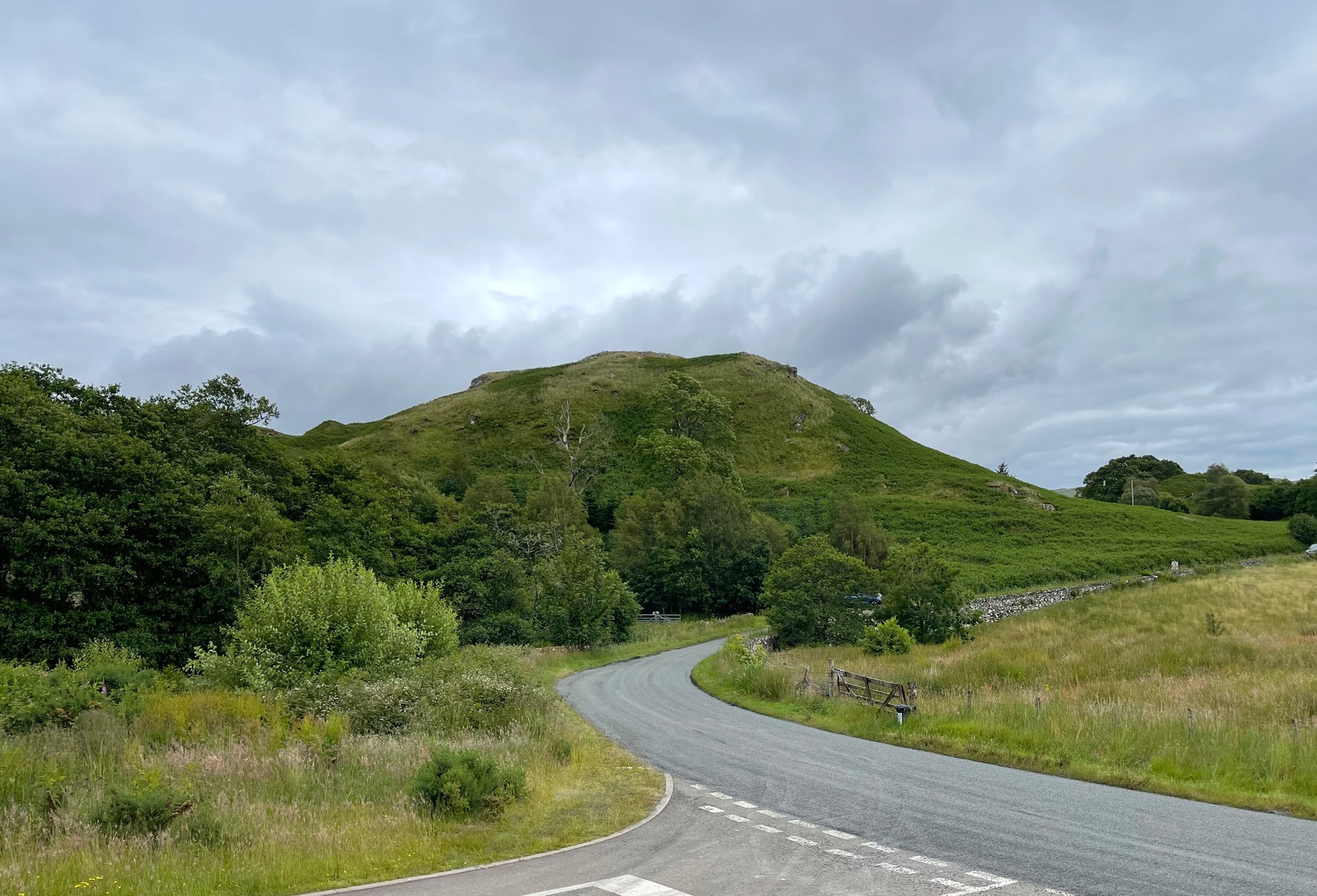
Take the A907 road between Clackmannan and Comrie and, close to Bogside Farm at the roadside, but on the other side of the road where the bridge crosses a burn, take the dirt-track uphill and into the woodland. About 300 yards up (before you hit the signs pointing you to the farm) , walk uphill into the trees on your left until the ground levels out. Look around! (and best visited between December and May, before the bracken covers the place)

Archaeology & History

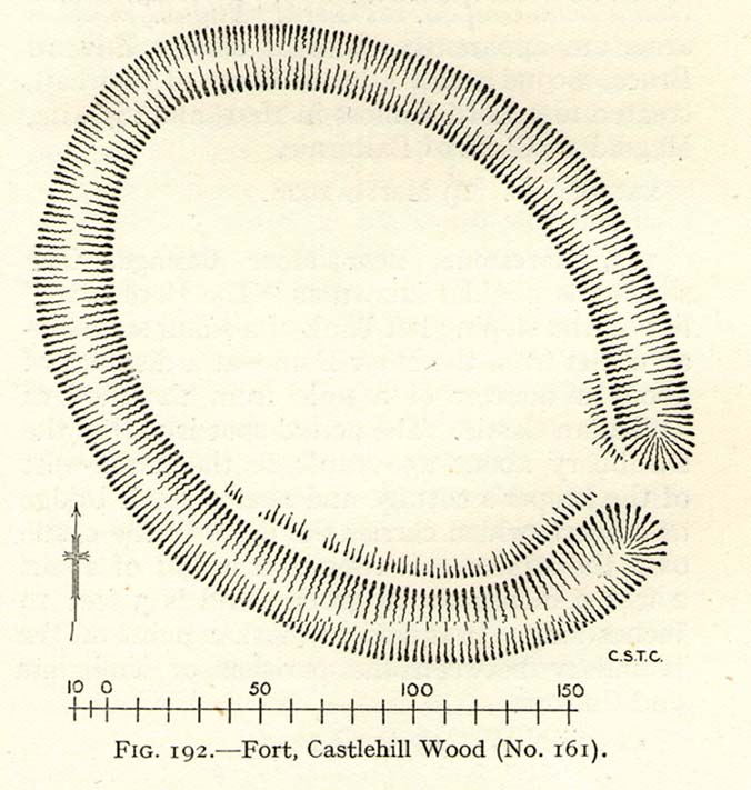
Visiting this site is pleasure in itself. Situated in an open forest, with traditional pine trees in abundance, there are scattered amidst the edges of this large oval-shaped Iron Age structure, the aged boughs of ash and beech, centuries old, along its edges and throughout the woods. It is a truly superb setting! When visited by the Royal Commission lads in April, 1925, they found the remains here in good condition. A few years later in their impressive Inventory, they told:

“In Castlehill Wood, about 250 yards to the southwest of Bogside Railway Station, and at an elevation of 200 feet above sea-level, is a small plateau of very regular oval form with its major axis northwest and southeast. It is surrounded by a single ditch, the well-marked enclosure thus produced having a maximum measurement of 185 by 135 feet. At the southeast the ditch has been left uncut in order to provide a passage for entrance. This passage has been about 20 feet wide, and at its inner end there are on either side faint traces of a low mound, which in all probability once ran right round the edge of the enclosure and which may have been palisaded.”

RCHAMS 1933 plan of site

Sadly when I came here a few days ago, much of the was very overgrown with bracken and other vegetation, making it impossible to see the site properly and preventing any decent photos. We’ll go back here in a few months time to get better images!

Folklore

This site was mentioned, albeit briefly, in David Beveridge’s (1885) magnum opus on the history of Culross.  With equal brevity he noted several standing stones in the region, saying how tradition afforded them a Danish origin.  This site was the same for

“a tradition prevails that after the battle of Inverkeithing the Danish army or a portion of it retreated to a station in the north of Culross parish, where they erected the earthwork or camp of Castlehill, still existing near the Burrowine Farm.”

References:

  1. Beveridge, David, Culross and Tulliallan: Its History and Antiquities – volume 1, William Blackwood: Edinburgh 1885.
  2. Royal Commission on the Ancient & Historical Monuments, Scotland, Inventory of Monuments and Constructions in the Counties of Fife, Kinross and Clackmannan, HMSO: Edinburgh 1933.

© Paul Bennett, The Northern Antiquarian


Firbrush Point, Killin, Perthshire

Dun (destroyed):  OS Grid Reference – NN 603 337

Archaeology & History

Not to be confused with the ‘fort’ shown on modern OS-maps on the wooded slopes a few hundred yards to the south, the denuded remains of this site were shown on an 18th century map of the area (the Breadalbane estate plans). Probably Iron Age in nature, the local historian William Gillies (1938) described the place in his fine work,

“According to the atlas of 1769 there were ruins of an ‘Ancient Castramentation’ at Firbrush Point on the farm of Auchmore. An examination of this little peninsula revealed the foundation of a very thick wall that at one time ran across its neck, and formed a defence on the landward side. It is probable that the stones were removed for the erection of the small pier and harbour close by.”

An assessment of the site by some of the Scottish Royal Commission lads in the late 1970s found no remains of the thick walling and it seems all remains of this fort have sadly been destroyed.

References:

  1. Gillies, William A., In Famed Breadalbane, Munro Press: Perth 1938.
  2. Royal Commission on the Ancient & Historical Monuments of Scotland, Archaeological Sites and Monuments of Stirling District, Central Region, Society of Antiquaries of Scotland 1979.

© Paul Bennett, The Northern Antiquarian 


Knock Hill, Dunblane, Stirlingshire

Hillfort:  OS Grid Reference – NS 7825 9845

Also Known as:

  1. Canmore ID 45987
  2. Gallow Hill

Getting Here

The snow-covered old fort

You can come here from either Dunblane to the north, or Bridge of Allan immediately south: either way you reach the site by going along the A9 road until you reach the Lecropt Church, a half-mile north of Bridge of Allan.  On the other side of the road is a somewhat battered wooden gate.  Go through here and up towards the tree-covered hill, following its edges to the right for a few hundred yards, until you come to another very large mound covered in trees.  That’s what you’re looking for!

Archaeology & History

Described on early OS-maps as a “Supposed Roman Camp,” this large fortified stone hillock has more recently been considered a creation of indigenous Scots.  Hemmed in and hidden on most sides, by the rises of Knock Hill to the west and Gallows Hill to the east, the only lines of visibility out of the fortress is along a northwest to southeast corridor, keeping the site quite secret to outsiders.  It would have been a fine place for a small community in ages not-so-long-ago, keeping the people hidden from the pestilent invasions of both Romans and english in bygone times.

The tree-clad fort, through blizzard

The large raised oval enclosure was walled around its sloping sides and edges, with remains of a walled embankment still visible running around the top of the slopes.  What may have been traces of hut circles were on top of the hillock until recent times, but these have been much reduced by some digging near the middle of the site.  It would appear that an ‘entrance’ was once visible on the southeastern side of the fort, but when we came here the other day, a lovely blizzard covered the place in snow, so this was difficult to see.

When the Royal Commission chaps came to visit the place in 1979, they didn’t really say much about the place, merely telling of its dimensions, saying:

“This fort measures 48m by 32m within the remains of a single rampart 4.5m thick and 1m high.”

I’m sure there must be much to be said of this lovely old site by local antiquarians, but I haven’t found much as yet.  But if you’re wanting a nice quiet spot to sit for a while on the outskirts of Stirling and Dunblane, I’d heartily recommend visiting this place.  Badgers and deer also seem to like the place!

References:

  1. Royal Commission on the Ancient & Historical Monuments of Scotland, Archaeological Sites and Monuments of Stirling District, Central Region, Society of Antiquaries of Scotland 1979.

© Paul Bennett, The Northern Antiquarian 


Nottingham Hill Carving, Gotherington, Gloucestershire

Cup-and-Ring Stone:  OS Grid Reference – SO 9875 2825

Archaeology & History

Nottingham Hill cup-and-ring

A rare find this!  In October 1981, in deepest Gloucestershire on the edge of the Nottingham Hill Iron Age hillfort, archaeologists sifting through what they ostensibly called “occupational debris” along the western edge of the huge enclosed monument, found a singular piece of local oolitic limestone etched with an archetypal cup-and-ring design!  The carving was on a typical ‘portable’ piece of stone and would not have been amiss had it been uncovered in a neolithic or Bronze Age cairn in our more northern climes.  But this southern example is something of an anomaly.

In Morris & Marshall’s (1983) description of the stone they told how,

“it was found as a loose block lying with the worked surface uppermost, and half-embedded in the plough-soil, together with other slabs and irregular lumps of oolitic limestone of similar size, and of closely related rock-type.  The object is a discreet slab with an unworked under-surface weathered by percolation of ground-water along a joint.”

Drawing of the carving

They found that the carved stone was typical of other rocks making up the ramparts at the outer-edges of the hillfort, and at some point in its history may possibly having been included in the walled structures of the fortress itself.  However, this is unlikely to have been the original use of the carving.  Its inclusion in the Iron Age ramparts would more be a likely consequence of it being appropriated from another, much earlier archaeological site in the area — a chambered tomb or long barrow for example.  This re-use of cup-marked stones in the Cotswolds is known to have occurred in the village of Salford, on the church cross-base, 18.75 miles (30.2km) east of here.

The Nottingham Hill cup-and-ring was described in some detail by Morris & Marshall (1983).  The rock on which it was carved measured one square-foot in size and barely 3 inches thick.  The central cup-mark measured,

“approximately 15.5cm in diameter, and a shallow radial groove (channel 1) leads from it to the edge of the stone.  The central cup-mark is surrounded close to its lip by a penannular channel or ‘ring’ (channel 2), which has a small depression at one end.  This end of channel 2 appears to be discontinuous with channel 1, but there is a very lightly pecked connection at the other end.  Outside channel 2 is a second shallower ring or channel (channel 3) but because of its shallowness it is difficult to determine whether it links with the radial channel 1.  Channel 3 contains a clear, small cup-mark part-way along its length, and is quite definite on one side of the central cup-mark, and on the other side it is possibly mirrored by a rather indistinct depression or cup-mark and length of channel.  Channel 3 is not continuous throughout its length, ending where it meets the edge of the stone beyond the small cup-marks.”

It is obvious that the carving, whenever it was made, was not subjected to long-term exposure to the outside air, as the carved design would have eroded quite quickly on the oolitic limestone.

References:

  1. Morris, Ronald W.B. & Marshall, Alistair, “A Cup and Ring Marked Stone from Nottingham Hill, Gotherington,” in Bristol & Gloucestershire Archaeological Society Transactions, volume 101, 1983.
  2. Royal Commission on Historical Monuments, England, Ancient and Historical Monuments in the County of Gloucester: Volume 1 – Iron Age and Romano-British Monuments in the Gloucestershire Cotswolds, HMSO: London 1976.

© Paul Bennett, The Northern Antiquarian


Rhiwderin, Newport, Monmouthshire

Cup-Marked Stone (lost):  OS Grid Reference – ST 260 870

Archaeology & History

Rhiwderin cup-marks

This fine-looking cup-marked stone was uncovered during a botanical outing in the last decade of the 19th century.  Described as being around the township of Rhiwderin, the exact whereabouts of the carving is unknown and it’s not been seen since the first description of it in an early edition of Archaeologia Cambrensis by Mr T.H. Thomas. (1895)  John Sharkey (2004) mentioned the site in his recent survey of Welsh rock art, saying simply “location unknown.”

The missing Rhiwderin stone

Although we know there are no hard and fast rules for working out the location of cup-and-ring markings, one may be fortuitous in exploring any nearby Bronze Age or neolithic tombs (cairns, tumuli, etc) in the Rhiwderin district, as they do tend to enjoy the company of such sites — but I must stress, this is by no means a dead cert!

Mr Thomas’s description of the carving was as follows:

“I enclose a sketch of what seems to be a cup-marked stone which I observed yesterday near Rhiwderin, Monmouth.  Unless there be some operation which simulates such markings with which I am unacquainted, I take the specimen to add an instance of these mysterious prehistoric remains to the very short list given for Wales by Mr. Romilly Allen, and to be the first reported for South Wales.

“The stone displaying the cup-markings is a mass of millstone grit, earth-fast, the slanting surface appearing above the turf being about a yard wide, and 4 feet long.  Upon the upper half of the surface is a group of twelve cups from 1½ to 2in diameter, and about 1in deep. On first noticing the cups they were taken for holes out of which quartz pebbles, abundant in the local millstone grit, had been weathered, but examination of the block showed that no pebbles of large size exist, or had existed in it, and the conclusion was arrived at that the cups are artificial.

“On turning back some of the turf covering the base of the slope of the stone, no other cups were discovered.

“The stone lies within an old enclosure, as shown by wild apple-trees and an abundance of daffodils, and still more clearly by ruins, which seem those of a cottage or small farm near by. This contiguity to a habitation which does not seem to have been abandoned more than a century, made me suspect some medieval or more recent origin for the markings. I cannot, however, account for them otherwise than by supposing them to be cup-markings in the technical archaeological sense.

“The stone was observed while in the company of Dr C.T. Vachell of Cardiff, searching for varieties of narcissus which occur at several points in the neighbourhood…”

If anyone comes across this lost carving, please let us know!

References:

  1. Sharkey, John, The Meeting of the Tracks: Rock Art in Ancient Wales, Gwasg Carreg Gwalch: Llanrwst 2004.
  2. Thomas, T.H., ‘Archaeological Notes and Queries,’ in Archaeologia Cambrensis, volume 12 (5th series), 1895.

© Paul Bennett, The Northern Antiquarian 


Dun Toiseach, Ford, Kilmartin, Argyll

Dun:  OS Grid Reference – NM 8808 0476

Getting Here

The hill of Dun Toiseach

You can see the rocky hillock ‘pon which this old dun sits from the roadside – and can approach it by either climbing up the slope, or go round t’ back and approach it from t’ track. Either way, it’s easy to get to.

Archaeology & History

This old dun was rather ramshackled when I used to sit here, sometimes on my way home from working at the Inverliever Nursery, a bit further up the lochside — but it was a good spot to sit and daydream into Loch Awe and beyond…

Described as a vitrified fort, the structure is oval in shape.  Thought to have been constructed in the Iron Age, Dun Toiseach was originally about 50 feet across and its walls averaged 10 feet thick, with an entrance at its northeastern side.  The Royal Commission lads (1988) described it thus:

Dun Toiseach plan (after RCAHMS 1988)

“Situated on a prominent rocky knoll overlooking the S end of Loch Awe 250m ESE of Torran farmsteading, there is a severely ruined dun measuring about 16m by 13m within a wall which has been some 4m thick. Two stretches of outer facing-stones are visible, as well as a few possible stones of the inner face, but, particularly on the NE, the wall has been severely robbed and the core material scattered. The entrance lies on the NE, the innermost portion of the SE passage-wall and what may be a door-jamb on the opposite side still being visible.  The knoll has acted as a focus for recent field-walls, but there is no indication that it was additionally defended by outworks. A small modern cairn…surmounts the dun wall on the SE.”

References:

  1. Royal Commission on the Ancient & Historical Monuments of Scotland, Argyll – Volume 6: Mid-Argyll and Cowal, HMSO: Edinburgh 1988.

© Paul Bennett, The Northern Antiquarian


Sheep Scar Enclosure, Giggleswick, North Yorkshire

Enclosure:  OS Grid Reference – SD 80648 66374

Getting Here

Aerial view of enclosure

To reach here, follow the same directions to get to the Apronful of Stones giant cairn.  Walk on the footpath past the cairn for about 200 yards until you reach a large gap where the old walling has collapsed.  Go through this and walk across the limestone rocks, towards the small rocky hillock rising up 100 hundred yards in front to your east (not the more rounded one to the north).  That’s it!

Archaeology & History

This is a most intriguing find, and one to which I can find no other literary reference (though I aint checked Brayshaw’s Giggleswick).  An undeniably large natural hillock has been modified and added to by people at some considerable time long ago and at some considerable effort!  Measuring more than 47 yards (43m) roughly east-west, and 21 yards (19m) north-south, the most definable man-made remains here is the length of elliptical walling on the southern and western edges.  The internal circumference of the enclosure measures roughly 113 yards (103m) all round the edges.  The northern and eastern sides of the hill would appear to be mainly natural, but seem to have been modified a little — not unlike the mass of settlements and enclosures a few miles to the east, like Torlery Edge, Lantern Holes and others around Malham Moor and district.

The site needs professional assessment: first to ascertain its period (which seems Iron Age on first impression, but could be much later), and second to ascertain its nature.  On the ridges close by we find a veritable mass of archaeological remains, ranging between Bronze Age to Medieval in nature.  The giant Apronful of Stones is only 172 yards (158m) south; the Sheep Scar cairn circle 156 yards (143m) northwest; and one of the remaining Sheep Scar cairns only 58 yards (53m) away.  And hopefully when we return to the place next week (fingers crossed!), we’ll be able to get some more photos of the walling you can see that define some edges of the site…

…to be continued…

References:

  1. Brayshaw, Thomas & Robinson, Ralph M., A History of the Ancient Parish of Giggleswick, Halton & Co.: London 1932.

© Paul Bennett, The Northern Antiquarian


Bedd y Cawr, Llanymynech, Montgomeryshire

Chambered Cairn (destroyed):  OS Grid Reference – SJ 266 223

Also Known as:

  1. Llanymynych Hill
  2. Llech y Wydhon
Scruffy 1835 ground plan of the lost tomb

Archaeology & History

An exact grid-reference for this once-impressive chambered tomb is difficult as “nothing remains of this site at the present day” (Daniel 1950) and the majority of the hilltop itself (a prehistoric hillfort no less), has been turned into one of those awful golf courses which are still spreading like cancer over our ancient hills.  It was obviously very close to the Shropshire border, as the folklorist Charlotte Burne (1853) said the grave was “on the Shropshire side of Llanymynech Hill,” perhaps placing it in the township of Pant.  But traditionally it remains within Llanymynech, within and near the top of the huge hillfort and east of Offa’s Dyke.

The old tomb was mentioned in an early letter of the great druid revivalist, Edward Lhwyd, who left us with the old ground-plan, reproduced above; and based on Lhwyd’s drawing and early narratives, Glyn Daniel (1950) thought the site “was perhaps a gallery grave”.  The best description we have of Bedd y Cawy was penned by John Fewtrell (1878) in his essay on the local parish in which he told:

“This interesting relic of antiquity stood on the north-eastern end of the hill.  It was formed of four upright stones, on the top of which was placed a flat slab measuring 7ft by 6ft, and 18 in thickness.  It is known by the name “Bedd-y-Cawr” (the Giant’s grave).  The British name appears to support the theory that the cromlech is a burying place, and not an altar devoted to religious purposes.  The word is derived probably from the Welsh cromen, a roof, or vault, and lech, a stone, meaning a vault formed by a slab supported upon uprights ; or, according to some, ” the inclining flat stone”.  Rowlands derives it from the Hebrew cærem-luach, “a devoted stone”, but this is far-fetched for a word or name in common use among our British forefathers.  Many regard the cromlech as a distinct species of monument, differing from either a dolmen or a cairn.

“When the covering of stones or earth has been removed by the improving agriculturist, the great blocks which form the monolithic skeleton of the mound and its chamber usually defy the resources at his command.  As the skeleton implies the previous existence of the organised body of which it formed the framework, so, upon this theory, the existence of a ‘ cromlech ‘ implies the previous existence of the chambered tumulus of which it had formed the internal framework.  Sepulchral tumuli were formerly classified according to their external configuration or internal construction; but more extended and critical observation has shown that mere variations of form afford no clue to the relative antiquity of the structures. But as it has always been the custom of the prehistoric races to bury with their dead objects in common use at the time of their interment, such as implements, weapons, and personal ornaments, we have in these the means of assigning the period of the deposit relatively to the Stone, Bronze, or Iron age.” Sometimes no traces whatever of human remains are found in the chamber.  Search was made to some depth in this cromlech, but nothing was found.”

In Fewtrell’s same essay he also described another megalithic site (also destroyed) on the southwestern part of the Llanymynech Hill, where,

“stood two rows of flat stones, parallel, 6 feet asunder, and 36 in length. A tradition exists which states that in digging near this place a Druid’s cell was discovered, but of what shape or size it does not relate.  There were a number of human bones and teeth in a state of good preservation also discovered.  In digging between the parallel rows a stratum of red earth was found, about an inch thick.”

Folklore

As the name of this old tomb tells, it was once reputed as “the Grave of the Giant”, but in Charlotte Burne’s huge work on the folklore of Shropshire (volume 1), she told it to be the tomb of his lady:

‘The Giant’s Grave’ is the name given to a mound on the Shropshire side of Llanymynech Hill, where once was a cromlech, now destroyed. The story goes that a giant buried his wife there, with a golden circlet round her neck, and many a vain attempt has been made by covetous persons to find it, undeterred by the fate which tradition says overtook three brothers, who overturned the capstone of the cromlech, and were visited by sudden death immediately afterwards.”

There is also a legendary cave beneath Llanymynech Hill which have long been regarded as the above of goblins and faerie folk.  More of this will be told in the profile for the hillfort itself.

References:

  1. Burne, Charlotte Sophia (ed.), Shropshire Folk-lore, Trubner: London 1853.
  2. Daniel, Glyn E., The Prehistoric Chamber Tombs of England and Wales, Cambridge University Press 1950.
  3. Fewtrell, John, “Parochial History of Llanymynech,” in Collections Historical & Archaeological Relating to Montgomeryshire, volume 11, 1878.
  4. Wynne, W.W.E., “Letters of E. Lhwyd,” in Archaeologia Cambrensis, vol.3, 1848.

© Paul Bennett, The Northern Antiquarian


Castle Hill, Little Wittenham, Oxfordshire

Hillfort:  OS Grid Reference – SU 5696 9244

Also Known as:

  1. Sinodun Camp
  2. Wittenham Clumps

Getting Here

Either reach this from Dorchester’s Dyke Hills by crossing the bridge over the Thames at its southwestern side and walk thru the village and up the fields to the wooded rise on your left; or simply get take the road between Brightwell-cum-Sotwell to the delightful village of Little Wittenham and, on your right-hand side, notes the unmissable clump of trees and rise in the fields on your right.  That’s the place!

Archaeology & History

Major Allen’s 1932 photo

To be found on the southern side of the River Thames, across from the huge Dyke Hills camp, this prominent enclosed hillfort was thought to be a place where the tribal peoples of differing groups converged — the Dubonni, the Catuvellauni, and Atrebates peoples.  And to this day it remains impressive.  Long thought to have been merely the province of Iron Age settlers, in more recent years it has shown to have had a longer and richer history than academics previously dare write about.  In Jean Cook’s (1985) fine work on the archaeology of the region, she described the typical narrative Castle Hill elicited from professionals until only a few years back, saying:

“The hillfort on Wittenham Clumps covers approximately 4 hectares (c. 10 acres) and comprises a single ditch and rampart.  It commands superb views northwards up the Thames valley and to the south and west across the Vale of White Horse to the Berkshire Downs, where a series of similar hillforts follows the line of an ancient route — the Ridgeway.  The fort has never been excavated, although frequent past ploughings have produced Iron Age and early Saxon sherds as well as Romano-British pottery.  However, to the south of the hillfort…a well-stratified Iron Age settlement was found.  It seems probable on the basis of other excavated sites that the fort was permanently occupied.  It would have developed as  a regional administrative and political centre, with specialist craftsmen and traders and would have performed some of the same functions as a medieval market town.”

Although Cook’s latter remarks should be addressed with caution (market economics was far from the mythic perspectives of Iron Age people), this great site was of obvious importance.  But later excavations at the site in 2002-03 showed that the site had in fact been used by neolithic people and, around the tops, flints and other remains were found that took human activity here back into mesolithic times, with some finds dated around 6000 BC!  More surprisingly (to archaeologists anyway) was that Castle Hill continued to be used way into medieval times!

Thankfully much of this place is still pretty well-preserved and is well worth exploring to historians, pagans and walkers.

References:

  1. Cook, Jean, “Before the Roman Conquest,” in Dorchester through the Ages, Oxford University 1985.
  2. Cook, Jean & Rowley, Trevor (eds.), Dorchester through the Ages, Oxford University 1985.

Links:

  1. An Interim Summary Report on Excavations at Castle Hill, Wittenham Clumps

© Paul Bennett, The Northern Antiquarian


Wallstale, Cambusbarron, Stirling

Dun:  OS Grid Reference – NS 7744 9085

Also Known as:

  1. Canmore ID 46232

Getting Here

To be found on the wooded hill about 160 yards north of Wallstale Farm, on the Polmaise Road on the western side of the M9, a mile or so south of Cambusbarron, below the hugely impressive Murrayshall Quarries.  Walk up the steep slope into the woodland and when you reach the level you’ll find the stonework remains.  It’s on the edge of the slope in the trees.

Archaeology & History

This old fortified walled structure is best seen in the winter months when all the vegetation has fallen back to Earth.  If you come here in the summer, the woods are nice but the monument can’t be seen as clearly.  Found at the top of the slope above the roadside, it was described in the Stirlingshire Royal Commission (1963) account as follows:

Ground-plan of Wallstale Dun (after RCAHMS 1963)
Wallstale Dun, up there somewhere!

“It is almost circular in plan…measuring about 45ft in diameter within a ruined stone wall some 11ft in thickness.  Except on the ESE side, where the entrance was probably situated, the wall can be traced continuously by patches of rubble core, and round the east half outer facing-stones are visible up to a maximum height of four courses.  In contrast, the inner face is only exposed for a short distance on the ENE.  The interior of the dun is featureless.  On the NW side the dun is protected by a rock-cut ditch of substantial proportions which traverses the spur; it measures 26ft in width at the top and the scarp is 5ft 6in in depth.”

References:

  1. Royal Commission on the Ancient & Historical Monuments Scotland, Stirling – volume 1, HMSO: Edinburgh 1963.

© Paul Bennett, The Northern Antiquarian