Tumulus (destroyed): OS Grid Reference – SD 866 309
Archaeology & History
Cliviger Laithe urn
The grid reference given here is an approximation as we don’t have the exact position of the tomb that could once be seen in the fields immediately south of Cliviger Laithe farm — but it’s a pretty good approximation! Overlooking the once proud cairn of Cliviger Law some 800 yards below to the southeast, Geoffrey Watson (1952) told us the site was “on the summit of the hill…which tailed off near Barcroft Hall,” but this area of the fields have been dug and quarried away in recent years, leaving no trace of the original tumulus that stood here. It also appears that the discovery of the site was quite an accident, Mr Booth (1899) telling us how the urns that were unearthed here were located “while some men were engaged in digging there.” As a result of this, we have little by way of description of the burial mound itself, but thankfully the prehistoric vase which they unearthed was kept intact. Of this artifact Mr Booth told:
“The vase came into the possession of a Mr Roberts…who lived at the old hall near the church at Worsthorne… By the kind permission of Mr Roberts I had an opportunity of making an examination of the interesting object. The urn itself was of a similar character to those already found in our locality* and measured 14 inches in depth, about 8 inches across the mouth, and 36 inches in circumference at its widest part… The vase “bulged” out in the middle, as these cinerary urns invariably do, and from thence it tapered down to a base of about 3 or 4 inches in diameter. It was ornamented at the top by the usual deep collar of about 5 inches in depth, the upper and lower edges of which were ornamented (with) encircling lines… The vase contained a large quantity of calcined human bones. Dr Dean gave as his opinion that there were the remains of two if not three human bodies, one of which was the body of a child… Besides the bones, the vases contained a quantity of charcoal and ashes, and also a very friable bone pin.”
The tomb evidently made a good enough impression on the Lancashire historian J.F. Tattersall as he took to writing a poem about the place! It went:
In this lone cairn upon the mountain head,
On one far morning of the misty past,
The earliest wanderers o’er these moorlands cast
A kinsman’s ashes to their narrow bed.
Now we, by Nature’s kindly guidance led
By marvellous ways, through revolutions vast
Of Time, her latest children, not the last,
Gather again around the ancient dead.
References:
Bennett, Walter, The History of Burnley – volume 1, Burnley County Council 1946.
Recently a good turn of fortune has brought about the discovery of a number of previously unpublished manuscripts detailing a number of prehistoric remains, holy wells and old stone crosses that existed in and around east Lancashire, Burnley, Cliviger and Todmorden. Many of these papers are the all-but-lost writings of historian and antiquarian Clifford Byrne of Nelson. Having never previously been published, I think his works deserve greater attention and so I’ll be slowly, gradually, sticking them on the internet and give them the wider audience they deserve. Not all of his notions are necessarily accurate, but the extent of this mans local history knowledge on the sites he describes in his essays is considerable. The following is his short essay—with minimal editing—on this all-but-forgotten site:
“Shorey Well, or rather its stone housing, was originally situated in the bank of the River Brun slightly upstream of the parish church at Burnley, at a spot now within the grounds of the Burnley Technical College. From within the stone housing issued the spring proper, which then ran down the brookside into the river.
“From time immemorial until the late 19th century, Shorey Well supplied part of the town of Burnley with its drinking water, then the water was impounded into a pipe and the stone housing removed to a place of safety. This housing was thought by our Victorian forebears to have sufficient merit to save it for posterity, and this act I feel implies more than a certain interest in the old stones which I suggest the movers of the Well probably did not themselves fully understand, and it is with this concept that I hope now to deal.
“The present location of the stones of Shorey Well is in the little triangle of greenery outside Prestige Ltd at Burnley. This spot is bounded on Colne Road and Bank Parade. Behind it squats the base of Burnley Market Cross and the remains of the stocks with — a little to one side — the shaft of the Godley Lane Cross standing out of a huge square pedestal.
“An old map in Burnley Library shows Shorey Well in situ with a well-defined row of stepping stones crossing the river directly in front. This line of stones went to the site of a still existing property called Shorey Fold — a spot that was probably once called St. Audry’s Fold, as we shall see.
“Godly Lane Cross is an Anglo-Saxon monolith with a somewhat damaged head. This damage was probably done around the time of the Reformation in the 16th century, when the anti-Catholic movement was at its height. The name Godly implies a god-like, or god-inspired or religious tone to the area, and Godly Lane — now Ormerod Road — certainly lived up to its name for there stood the parish church, the Cross itself, the Market Cross, another cross dedicated to a priest in the 16th century and now standing in the rear of Townley Hall, “Foldy’s Cross”, with nearby Shorey Well.
“There is a strong possibility that the Godly Lane Cross — sometimes called the Paulinus Cross — was a preaching cross and that it also marked the way to Shorey Well which issued close by.
“No one to the knowledge of the writer has attempted to explain the name Shorey Well. I therefore suggest that the Well was used for baptism and that it was dedicated to St. Audry. The parish church was erected prior to the Reformation and thus certainly had its Holy Well close by, from which the priests obtained water for baptism and blessings, etc. Because of its propitious nature and close proximity to the church, such a Well would almost certainly have been the Shorey Spring.
“A study of the name may be fruitful. Holy wells are almost always dedicated to some christian saint. However, many of them have undergone a slight change in name over the centuries, so that it is not always easy to recognise the dedication. For instance, the Ransible Well near Colne was dedicated to Our Lady of Ransome, or the Virgin Mary; Stellern Well was dedicated to St. Helen; Maudlin Well near Lathom House was dedicated to St. Mary Magdalen; Pewter Well at Sabden would be St. Peter’s Well; Mattus Well at Sawley Abbey is St. Matthew’s Well; whilst Cooks Well at Colne was surely dedicated to St. Luke the physician. Thus Shorey Well in the same context is almost certainly dedicated to St. Audry, and this saint we find was one of the most revered saints in Anglo-Saxon times, from which date the Godly Lane Cross stems.
“The close proximity of church, well and cross surely imply that one showed the way to the other, and that all three were at one period of time one unit: the Cross being a preaching place prior to the Church, and the holy well being a place of baptism and healing.”
Mr Byrne’s etymological reasoning may or may not be right here (Mr Ekwall says nothing in his place-name survey and I’m unaware of local dialect analysis that may account for the word), but the description of this and numerous other lost and forgotten sites in his various papers is hugely worthwhile and is a source of considerable study for us over the coming months.
Ormerod (1906) described the site in his tome, but even in his day this once great well with its “abundance of sparkling water” was “disused and neglected.” (the image above is taken from his work) However, as if to dispel any notions of an earlier saintly dedication, we find that in Walter Bennett’s (1948) magnum opus, the site had a more prosaic title in bygone years:
“Whittaker’s Well, or Shorey Well as it was later known, was situated on the riverbank opposite Dawson Square, and was apparently the only public source of drinking water for the inhabitants of tge Top o’ th’ Town.”
References:
Bennett, Walter, The History of Burnley – volume 3, Burnley Corporation 1948.
Byrne, Clifford H., “A Short Study of Shorey Well, Burnley,” unpublished manuscript 1976.
The Nanny Howe burial mound was one of a group of at least three tumuli that could be found on what is now the wooded hilltop of Coate Moor, a mile east of Great Ayton. Large and conspicuous in previous centuries, the site was described briefly in Elgee’s (1933) archaeological survey as being in association with a prehistoric settlement, which itself appears to have long since succumbed to forestation. An essay on the state of this apparent Bronze Age burial mound was written by Mr Hayes (1966), who told us:
“The kerb of the barrow was exposed and noticed by J.N Grayson whilst excavations were in progress on Great Ayton Moor. S.V. Morris, A.N. Pacitto and the writer examined the site. It was a cairn of about 30ft diameter and 3ft high in the centre, with a strong kerb of stones set on edge of 25ft diameter. Its construction, of massive stones was similar to the chambered cairn on Great Ayton Moor, one mile to the north, and very like the food vessel-urn tumulus on Danby Rigg which also had a kerb of the same diameter…
“When the heather and turf were removed on the south-east side of Nanny Howe, a mass of cremated bones with part of the rim and side of a typical Iron Age ‘B’ jar were found only 6-9in under the turf. This was clearly a secondary burial long after the cairn was built. The sherd may have been a token offering, but more probably the remainder of the pot so near the surface of the mound had been eroded. No other secondary burial was found, although almost all the cairn was removed.
“Under large boulders in the central area was a shallow pit or depression… Only minute specks of charcoal and some small burnt stones distinguished its filling from natural sand. It was about 3ft in diameter and not more than 9in deep… In it were the broken sherds, more than 80 in number, of a beaker… There were no signs of bones or cremation, although presumably a contracted skeleton had accompanied the beaker. In the acid sand all bones would perish quickly… No other relics were found in the cairn.”
To which Mr Hayes and his team concluded the Nanny Howe tomb was an example of a typical “beaker burial” as they used to like calling them, set within a ring of stones over which the cairn was piled; and long after this, seemingly the Iron Age, a secondary cremation was inserted.
Folklore
Folklore ascribed the entire settlement here to have heathen origins, with Nanny Howe also standing out with folklore of its own. As Mr & Mrs Elgee (1933) wrote:
“Half a mile east of Captain Cook’s monument…on Easby Moor is the Devil’s Court, where, according to tradition, witches congregated under the presidency of their lord and master. We therefore examined the Court and found what we expected, a typical moorland Bronze Age settlement site, with stone-walled enclosures, shallow pits, flint implements and many barrows, one of which is named Nanny Howe, after a famous witch, it is said, who also frequented Nanny Nook, a right-angled bend in a stone wall near Wayworth Farm, Commondale, marking another settlement site.”
Another tale of this legendary witch was narrated by folklorist and historian Richard Blakeborough in one of his many tomes, where he told:
“Again, old people of Great Ayton still aver that on a certain night a once noted witch, Nanny Howe, may be seen riding astride on a broomstick over Howe Wood just at midnight. This witch, so mounted, is said once to have chased the devil for miles — on this occasion the two must have fallen out ; perhaps at that time honest folk got their due. Howe Wood is near Kildale.”
Whatever the source of such stories, the respective archaeologists of Elgee and Hayes wondered if they derived from some pre-christian rites and events. Hayes asked:
“Was the person interred in Nanny Howe a famous witch? Or were the witch and the devil legends connected with the site faint echoes of ceremonials and rites held here?”
It would seem likely that the local peasant communities hereby were, thankfully, not inflicted with the empty spirituality of the christian cult when it tried taming the souls of the villagers living in and around here. The folklore would seem to reflect simple peasant gatherings and celebrations, frowned upon by those weird clergy-folk, no doubt striving to get the local children into their more demonic pastimes…
References:
Blakeborough, Richard, Wit, Character, Folklore and Customs of the North Riding of Yorkshire, W. Rapp: Saltburn 1911.
Elgee, Frank & Harriet, The Archaeology of Yorkshire, 1933.
Gutch, Mrs E., Examples of Printed Folklore Concerning the North Riding of Yorkshire, David Nutt: London 1899.
Hayes, R.H., “Nanny Howe, Coate Moor, Cleveland,” in Yorkshire Archaeological Journal, part 164, 1966.
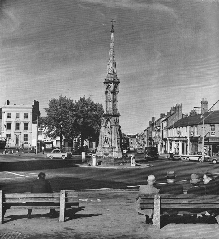
The original stone monolith that stood here has long since been destroyed (by christians arguing amongst themselves) and the ornate edifice that we see today was erected in 1859 to commemorate the marriage of Queen Victoria’s eldest daughter, Victoria Adelaide Mary Louisa, to Friedrich Wilhelm of Prussia. Standing more than 52 feet tall, it is of a neo-Gothic design and is one of the tallest crosses in the country. Originally there were going to be six carved statues cut into the niches of the cross, but this was later reduced to three.
First mentioned in place-name records from 1478, the original stone cross was itself very prominent, rising some 20 feet tall and sitting upon a square base of eight steps. It was described by John Leland in his Itinerary when he visited the town sometime between 1535 and 1545, who said:
“At the west part of the street…is a large area, having a goodly cross with many degrees (steps) about it. In this area is kept every Thursday a very celebrated market.”
The old cross was also a site where public notices and proclamations were dispensed to local people and seems to have been an old meeting place. Whether it had a prehistoric predecessor isn’t known.
Folklore
The nursery rhyme we’ve all recited when we were kids and growing-up, has much of its origins around this ornate edifice and in the 20th century was thought to have its origins in pre-christian practices hereby, but this is questionable. The rhyme, to those who don’t know it, goes:
Ride a cock-horse to Banbury Cross,
To see a fine lady upon a white horse,
With rings on her fingers and bells on her toes,
She shall have music wherever she goes.
As Kirsten Ayles (1973) told:
“This rhyme was first recorded in 1784, but it probably originated much earlier. The Banbury Cross mentioned was destroyed at the turn of the 16th century by the Puritan inhabitants of Banbury. It has been suggested that “bells on her toes” points to the fifteenth century, when a bell was worn on the long tapering shoe of each shoe. It has (also) been thought that the “fine lady” was Queen Elizabeth I, or Lady Godiva.”
Another option identifying the “fine lady” in the rhyme is perhaps a member of the Fiennes family, ancestors of Lord Saye and Sele who owns nearby Broughton Castle.
References:
Ayles, Kirsten, “A Short History of Nursery Rhymes,” in This England, 6:3, Autumn 1973.
Gelling, Margaret, The Place-Names of Oxfordshire (2 volumes), Cambridge University Press 1954.
Vallance, Aymer, Old Crosses and Lychgates, Batsford: London 1920.
Acknowledgements:
To Ronald Goodearl, for use of his 1973 photograph of the Banbury Cross.
Travel along the Askwith Moor Road between Blubberhouses and Askwith (near Otley) and park-up at the large gritted parking post on the moor edge. Walk straight onto Snowden Moor (east) and walk a few hundred yards north until you reach the brow of the small rounded hill, scattered with small stones and outcrop rock. The settlement is all around you!
Archaeology & History
As we already know from earlier posts on TNA, this moorland region is rich in prehistoric remains, and the settlement that I’m about to briefly describe here is another excellent site – when you can see it!
‘Hut circle’ at the rocky knoll
My first exploration here was in the company of Graeme Chappell more than 20 years ago, where we tried locating remains that had been described by Eric Cowling (1946) during a foray taking photographs of the cup-and-ring stones nearby. But due to an overgrowth of moorland vegetation at the time, the remains which Cowling described proved hard to find. Years later when Richard Stroud and I visited the place in May 2005, all the heather had been burnt back and much of what looked like the remains of an entire prehistoric village was in plain view for us to see. I was well impressed! This occurred again last year, enabling the bunch of us who came here a few times to see even more of the place. But — just like the newly discovered prehistoric settlement on Blubberhouse Moor a couple of miles north — once the heather grows back again you wouldn’t really think anything of worth was hidden here. In archaeological terms however — despite the lack of references and research by those who are paid to be archaeologists — we have one helluva little-known prehistoric settlement, complete with walling, hut circles, village hall (!), tombs, cup-and-ring carving and more, much of it probably dating from the Bronze Age, but some of the sites here indicate it was also much in use during the Iron Age period aswell.
Probably the best place to start exploring here is on the large flat rock on the rounded knoll at the edge of the moor (SE 1785 5129) with a simple cup-mark saying ‘hello’ on its surface, looking east down into the Fewston Valley and across lower Wharfedale, then veering up towards the hills above Nidderdale. The great prehistoric temple of Brimham Rocks is clearly visible from this spot aswell. Upon this rocky hillock we have a veritable scattering of several large, earthfast boulders and smaller rocks, from where much of the settlement expands, mainly to the west through to the south, across the open moors in front of you. On a clear day this is truly beautiful and quiet spot.
Line of ancient walling, running NELine of ancient walling, running SW
Just a couple of yards from the edge of the rocky knoll is a very good example of what would at first sight appear to a prehistoric hut circle. Its position at the top of this rocky knoll however, implies an additional function other than a purely domestic one. Also from here is a prominent long straight stretch of walling running roughly southwest for about 90 yards onto the moor, and also to the northeast, downhill off the moorland for some 30 yards before disappearing into undergrowth (we didn’t actually explore this lower section of walling running downhill, so there’s probably more to be found there). This long section of walling, mainly comprising small stones and rubble, with a number of larger uprights defining much of its length, is just one of several stretches of walls that are clearly visible hereby. There are also a number of other hut circles to be found scattered around this particular walled sections near the top of the rocky rise. When Eric Cowling (1946) came here he counted 10 of them here; but subsequent explorations have found at least 13 of them hereby.
One of the most notable remains here is the large D-shaped enclosure about 25 yards west of the rocky knoll. This very impressive archaeological site was curiously not included in the Nidderdale Archaeological survey report of sites in this region. Either they hadn’t done their homework correctly when they came here, or the heather must have been really deep; cos as you can see in the photo here, it’s a decent size! I tend to see this large stone enclosure as a sort of tribal gathering building of sorts — a bit like a ‘village hall’ so to speak. If you get here and see it all in context, it makes a lotta sense (not that it’s right of course, merely an opinion). With the exclusion of the Cowling D-shaped enclosure more than 80 yards east of here, this is the largest monument on this section of the moor, measuring some 45ft along the NW to SE axis and 20ft across the NE to SW axis. The walling in parts is quite thick aswell and the stones making up the main north, east and southern edges are anything between 12 inches to 34 inches tall. Along its northeast edge is a curious stone, with what initially looked to be a most distinct cup-and-ring carving on the outer walling, but once we’d looked and looked again, saw it seemed to be one of the oddest light-created ‘carvings’ we’d ever seen! (i.e., it’s natural)
Denuded cairn? or denuded walling?Another arc of walling (shit picture though – soz…)
A few yards from here, heading to the little peak close by, more walls emerge. On the small rise in the land about 30 yards west you’ll see an arc of stones running around the contour line of another hillock on the moor. It’s difficult to say with any certainty, but a lot of this arc of stone is certainly man-made and at least Iron Age in date, perhaps earlier; but the line of stones itself may actually run all round the very edges of the hill on whose sides this section rests (see photo). You get a distinct impression here that this small hill was actually sectioned off all the way round, so to speak, for some reason or other. The remains of at least two small cairns can be found on the top of this small enclosed rise, close to one of which Boughey & Vickerman (2003) have designated there to be a cup-marked stone. From this elongated hillock we look immediately northwest onto the flat moorland plain of the Snowden Moor necropolis …amidst which the hardworking Keighley volunteer Michala Potts recently found the Snowden Crags cairn circle.
Section of Snowden Carr settlement walling
Further down the moorland slope—a couple of hundred yards below Cowling’s D enclosure—are yet more remains, many of which lie outside the geographical boundaries of the “official” Scheduled Monument Record for this settlement (known as SMR 28065). We’ve located several other cairns in relatively good states of preservation; more extensive lines of another walled enclosure (again in a large D-shape), as well as several cup-marked stones.
The Site and Monuments account of this place tells us simply:
“The monument includes a cairnfield and associated concentration of prehistoric features. Included in the area are a large sub-rectangular enclosure, two smaller enclosures, at least 17 cairns of various sizes, several lengths of boulder walling, a hollow way, and at least 17 carved rocks. There is also a bare patch of ground on which lumps of lead slag survive. This was produced by medieval or earlier lead smelting.
“This concentration of prehistoric features is situated towards the north east edge of Snowden Carr, and measures c.426m x c.155m. The cairns occur throughout the area and range in size from an elongated cairn 17m x 7m down to cairns c.4m in diameter. The cairns are best preserved in the north western part of the area. The large sub-rectangular enclosure has an earth and stone bank c.3m wide and c.0.6m high. The bank is double on the east side of the enclosure. The two smaller enclosures have rubble banks 1m-2m wide and up to c.0.6m high. They are more irregular in shape than the large enclosure. The boulder walling consists of a number of approximately linear rubble banks 1m-2m wide. It is concentrated in the area immediately north west of the large enclosure, and in the area to its south. The boulder walls are interpreted as part of a field system contemporary with the large enclosure. The hollow way is located within the southern group of boulder walls and may be contemporary with them. “
There is still a considerable amount of work that needs doing in and around this settlement complex and it seems any work here is gonna be done by the like of us amateur doods. Archaeological officials don’t seem interested here. I was informed by Neil Redfern of the archaeology department of English Heritage for North Yorkshire that they are unable to support any funding that might help towards any decent analysis of this important archaeological arena, nor do they consider the important cairn circle discovered a few months ago on the northern end of this settlement worthy of financial help either, which is of course very disappointing,* but typifies their lack of enthusiasm unless money comes their way. And so this site profile entry will be added to gradually as our amateur team visit and uncover further aspects of this neglected prehistoric arena – such as the finding of another previously unrecorded ancient circle of stones not too far away!
References:
Boughey, Keith & Vickerman, E.A., Prehistoric Rock Art of the West Riding, WYAS: Wakefield 2003.
Cowling, Eric T., Rombald’s Way: A Prehistory of mid-Wharfedale, William Walker: Otley 1946.
Acknowledgements: Many thanks for use of their photos to Graeme Chappell and Michala Potts.
* No doubt a church window somewhere will eat up a few thousand quid and weeks of their time to fit the little piece — along with all those prawn sandwich meetings that cost so much to endure. Much more important!
A huge linear monument that could once be found on the flats just north of the B6271 road running between the villages of Scorton and Brompton-on-Swale, east of the ancient A1 road, has long since been ruined. Although found quite a few miles north of the main Thornborough henge and cursus complex, a number of students still posit that this northern monument was part of the same “ritual landscape” arena.
Plan of the cursus (after P.Topping, YAJ 1982)
First discovered in 1949 following aerial survey analysis by Prof. J.K. St. Joseph, this huge dead straight cursus monument ran for at least 1.3 miles (2.1km) and would have been considerably longer if the self-righteous advance of industry hadn’t quarried it away (such is “progress”!). Built along a southeast to northwest axis, the southern end of the cursus was straight and flattened (as opposed to convex, as found at some cursuses), as Peter Topping’s (1982) illustration of the monument here shows, but the northwestern end of the cursus has not been found. As Mr Topping himself wrote:
“The southwestern terminal, which shows clearly on the aerial photographs, consists of a straight transverse ditch which joins the two main ditches at right angles. Clustering around it was a series of ring-ditch cropmarks. The aerial photographs also show a series of bleach marks between the ditches at the southern end of the cursus, which may represent a series of contiguous mounds. This area of the cursus also features what appears to be smaller outer ditches…”
Topping also commented on a most “noteworthy feature” in the accuracy of the ditches that constitute the length of the monument, being so “remarkably straight considering the distance over which they extend.” Features which, in bygone days, a number of respected archaeologists denied our prehistoric ancestors the ability to execute.
Hopefully readers will forgive me citing more of Topping’s extensive notes regarding the archaeological analysis of this site, but I think they’re worthwhile. Of the ditches that make up the outline of the cursus, he told:
“The ditches of the cursus are the two most prominent features of this site on the aerial photographs. …The only evidence available for the existence of the cursus in the area to be excavated was a section exposed in the adjacent gravel quarry. This section clearly illustrated quite distinct re-cut features visible in the profiles of both ditches, and evidence of this recutting was also discovered in the excavated areas. However, one anomaly which did distinguish the excavated sections from those exposed in the quarry was the variable depth of the ditches. In the quarry-face sections the western ditch had a maximum depth of 60cms, while in the excavated area its maximum depth was 45cm; similarly, the eastern ditch had a maximum depth of 65cm in the quarry and a maximum depth of 43 cm in the excavations. This may have resulted from the actions of hillwash or ploughing reducing the height of the old land surface in this area where the ground naturally rises, or alternatively indicate no more than an uneven depth to the ditches. Their width was fairly consistent, the maximum width of the eastern ditch being 3.40m, while that of the western ditch was 3.85m.
“Recutting in both ditches was indicated by a V-shaped notch beneath the main profile of the ditch…
“Closely datable artifacts were sadly lacking in the ditches, the one possible exception being (a) flint…possibly an arrowhead, from the upper fill of the eastern ditch… The upper fill of the eastern ditch also produced (a) flint…”
But in all honesty, these flint finds were probably of little importance to the cursus itself and can be discounted as of any relevance outside of being stray hunting flints. Three other flints were discovered by the western ditch aswell, again with little significance to the monument. But the next part of the excavation work explored what Topping called the ‘Central Feature’, of which he said:
“Bleach marks on Prof. St. Joseph’s aerial photographs revealed what appeared to be a series of axially-placed contiguous mounds situated between the main ditches, and extending the whole length of the long axis of the monument as then known. The presence of this feature was confirmed in the excavated area. A low central mound was uncovered, within and respecting the lines of the ditches, which had a maximum height of 32cm above the old ground surface.”
Upon further excavation they found what one would have expected: little more than the upcast of earth and gravel dug out from the ditch that makes up the cursus, i.e., spoil-heaps made where they’d dug out the cursus lines with little other significance. This feature is obviously apparent in many cursuses. Of greater interest was the pit- or post-hole on the eastern ditch.
“This was stratigraphically related to the cursus to the extent that it was sealed by the same layer of hill-wash that had buried the cursus ditches. In addition, this feature clearly respected the limits of the eastern ditch. The dimensions of the pit/post-hole were: maximum diameter at its base, 1.12m, the maximum width at its top, 2.10m, length, 4.19m, and a maximum depth of 60cm.
“…Distinct tip-lines were evident leading in and downwards towards the centre of the feature, this central area being relatively stone-free. This could suggest that the feature originally held a post which was subsequently removed at a later date.”
I’d say this notion is highly likely! In the event that a complete excavation could have been made here, it’s probable they would have found other pit-holes into which upright wooden posts were erected around the time the cursus was constructed. When Topping and his team excavated sections of the eastern ditch-floor, they found what appeared to be the truncated base of another post-hole. He told:
“This feature was sectioned and found to be flat-bottomed and to have a depth of only 3cm and a diameter of 25cm. The fill was indistinguishable from the fill of the cursus ditch and contained no traces of organic material…although the exact function of this feature is unknown.”
Topping’s conclusion about the nature and function of this monument is a simple one:
“it can be seen as part of a concentration or complex of magico-religious structures.”
And although this is a somewhat tentative notion based on the limited archaeological evidence here, it does accord with standard views in comparative religion on the animistic relation humans had with natural and man-made monuments from this and later periods of history; as well as reflecting the findings on the origin and development of human consciousness in Jungian and other applied psychology schools. The construction of this gigantic landscape feature occurred at a period in human history when the division between the sacred and the profane had yet to emerge culturally. In all likelihood, Mr Topping’s notion is correct.
From Colne train station, cross the road and go along Bridge Street and where it meets Knotts Street follow it all the way up into the countryside and, bending to the right, uphill again until it levels out. The farmhouse a few hundred yards ahead of you (just off Southfield Lane) at the bend in the road is where you’re heading. There’s a track on your right, just before the farm. Go on this and look into the field immediately right. The undulations and earthworks are the remains of this old hillfort!
Archaeology & History
This old site was constructed some 850 feet above sea level, overlooking the valley of Colne immediately west and giving commanding views of the outstretched landscape towards the sacred Pendle Hill and beyond for many miles. The place was described as early as Castell Clif in 1515, and then again as Castyclyff in 1533, meaning simply the “castle on a cliff” or high verge as it is here. Yet despite its early appearances in literary studies, the first real work to explore this monument doesn’t appear to have been done until one J.A. Plummer carried out work on the site between 1958-60. However, Plummer died before being able to publish his findings in full. Ascribed variously as a settlement, an enclosure, and generally in the archaeological fraternity as a hillfort, the first detailed published description of the site was done by Forde-Johnston (1965), where he told:
Forde-Johnston’s early plan
“The hillfort is a very regular oval in shape and encloses an area about 350ft long and 250ft wide. The overall dimensions are 550ft by 450ft. The site has been affected by quarrying on the south and east and there are a number of gaps in the defences on the northern and western sides. The character of the remains differs in various parts of the site, but the general pattern appears to be as follows. The innermost line of defence is represented by a very slight bank or, in many places, only a very shallow scarp which can be traced round the whole circuit of the site… The second or middle bank is the most prominent or substantial of the three. It has considerable gaps in its length, but the various portions are all of much the same character — it rises between 3 and 5ft above the interior and falls about 9ft to the ditch bottom. On the south side the middle rampart takes the form of a scarp about 10ft high, immediately below the scarp of the inner rampart. The third, outermost bank is, in fact, a counterscarp bank to the second ditch. It does not exist as a continuous bank around the whole of the site, but there are sections of it on the northern and eastern sides. On the eastern and northeastern sides, from which approach was easiest, there appear to have been additional outer defences, situated about 70ft forward of the counterscarp bank. These outer defences now take the form of a scarp about 4ft high curving round the eastern and northeastern sides for about 250ft. At the southern end there is an inner scarp, forming a bank, and a little to the south, is a detached portion of bank. There are other short detached sections of bank on the northern side which are presumably to be connected with these outer defences.”
When Mr Plummer did his excavation here a few years before, one section of the site was examined and, thanks to the survival of an interim report he did — described by D.G. Coombs (1971) — we know the following of what he did:
“His work was concentrated in the northwest corner of the site where he cut a trench through the defences. Outside the counterscarp bank, which was not continuous, there was a bedding trench, packed with stones and containing charcoal. The ditch, which was rock-cut and flat-bottomed, had a homogenous fill. The rampart itself showed timber supports at the front and back with traces of stone revetting at the front and some distance from the timber uprights. The rear of the rampart was marked by a line of stones. Behind this rampart the site had been extensively disturbed and here he claimed to have found traces of primitive iron-smelting furnaces constructed from stones packed and sealed with loose black earth. A single post-hole beneath the rampart was suggested to belong to an earlier phase.”
Though we have to note here that Mr Plummer believed that the iron furnace remains were actually medieval in date, but that the embanked settlement itself was Iron Age and “that the collapse of the fort could be dated between 60-90 AD.” When Mr Coombs and his team came back here in 1970 to re-examine the works of both Plummer and Forde-Johnston, they confirmed some of their earlier finds, but uncovered additional finds at what they called this “once great fortress.”
Folklore
In Robert Lord’s (1976) superb imaginary piece on what he calls the Pendle Zodiac (a zodiac allegedly forged into the landscape in ancient times, in the manner of the famous and equally imaginary Glastonbury zodiac), a section of the deity Diana is made up of this prehistoric earthwork:
“The lower edge of the cap (on her head) coincides with a minor road between Colne, skirting the Iron Age Castercliffe hill-fort, above Nelson, as far as Catlow.”
In days of olde this once proud tomb stood upright on the slopes below the more prominent Cliviger Laithe tumulus above. But, like many of the ancient ancestral tombs of this region, its days seem long gone. Although we’ve found what may be some traces of the outline of the cairn (further analysis required!), when the legendary Lancashire historian Thomas Dunham Whitaker (1872) wrote about the place, he was already writing about it in the past tense. He said briefly, that “this heap of stones was removed as materials for building a turnpike road” in 1763. The archaeologist Bernard Barnes (1982) told us that “a cist with an inhumation was found. In 1766 another tumulus was removed and an urn found. An axe-hammer is said to have been associated” here. The most lengthy description of this site can be found in Mr Booth’s (1899) short work where, in his summary of various prehistoric sites in this region, he told that,
“The first find recorded in this locality took place at Law House, near Mereclough, in the year 1763, when a mound was opened which covered a kistvaen, or stone cist, which, upon being opened, was found to contain a human skeleton. The information concerning this ancient burial is very meagre, and we have no information as to who were the discoverers of the mound. It may be noted that nearly 70 years before (in 1695) a number of Roman coins were found close to this barrow. The mound also contained a rude earthware vase filled with calcined bones.”
It’s unlikely that the earthworks by the walling hereby represent the denuded remnants of the monument in question, although the rise in the field here may be some remnant of the place, but without further excavation we might never know for sure. However, the recent discovery of what may be remnants of the cairn in an adjacent field requires further analysis. WATCH THIS SPACE – as they say!
References:
Barnes, B., Man and the Changing Landscape, University of Liverpool 1982.
Bennett, Walter, History of Burnley, volume 1, Burnley 1946.
Booth, Thomas, Ancient Grave Mounds on the Slopes of the Pennine Range, R. Chambers: Todmorden 1899.
Whitaker, T.D., History of the Original Parish of Whalley, London 1872.
Cross (destroyed): OS Grid Reference – c. SD 881 353
Archaeology & History
Not included in the magnum opus of Henry Taylor (1906), the exact position of this long lost site remains unknown, as even the investigative abilities of Clifford Byrne couldn’t track it down! It was erected in a region full of pre-christian remains and (at the time) living remnants of heathen folklore and practices between Worsthorne and Nelson. Mr Byrne (1974) described his search for the place, saying:
“This cross is of ancient origin and no part of it now remains as far as can be ascertained by investigation, although the memory of it certainly remains, for an elderly gentleman living in the cottages of Holt Hill, Briercliffe, said instantly on being asked about he cross that he had often heard it referred to by older people when he was a boy, although he could not say exactly where in the hamlet the monolith had stood. We are told that the cross is mentioned in a document in the year 1313 when Robert Briercliffe granted away the Sene intacks in the Holt Hill as it lay by Annot Cross on the south side. This implies that it stood on the south side of the road (between) Thursden and Haggate, which is an old road from Burnley to Halifax…”
This would give a rough grid reference for its position around SD 881 353, but nothing appears to be there. However, Byrne told of another intriguing bitta folklore a short distance away which may have had some relevance to the positioning of the cross.
“Down the road to Lane Bottoms, behind some bungalows, is a stone shaft in a depression in a meadow which we are told is an ancient standing stone. Whether this is so is not easy to ascertain for the stone has apparently been used as a gatepost at some time, and further gives indication of having been utilised as a cattle rubbing post.”
Below here we find the old place-name ‘Burwains,’ which clearly indicate a site of a prehistoric burial, though nothing remains of such a place — officially at least. Perhaps a couple of ventures in and around this area need to be done! One final note that Byrne made related to the title of this lost cross, saying:
“The name “Annot” may be of Saxon origin, for the Saxon word annet means solitude, and this would have certainly fitted the area in ages past.”
References:
Byrne, Clifford, A Survey of the Ancient Wayside Crosses in North-East Lancashire, unpublished report 1974.
Taylor, Henry, The Ancient Crosses and Holy Wells of Lancashire, Sherratt & Hughes: Manchester 1906.
Follow the same directions as to reach the so-called Smiley Stone carving and look just 10 yards SE.
Archaeology & History
About 10 yards away from the Smiley Stone is another of Middleton Moor’s ‘dubious carvings’ to me. I remember seeing the drawing of this years back, perhaps a decade after Stuart Feather first described it (1966) and remember thinking it looked a bloody good carving. But when I saw it for the first time in February 2005 with Richard Stroud, not only could I hardly see what was supposed to be there, but once I’d seen the alleged design, some doubt came over me regarding its archaic nature. That doubt still remains.
Faint cups & linesDesign on carving 447
There certainly seems to be a few faded cup-marks on the stone — which looks to be broken from a larger, circular worked stone of a much more modern age (an old mill stone perhaps?) — but the lines which both Feather and the grand pair of Boughey & Vickerman (2003) copy into their survey, are all too vague and certainly not ancient in my book. Perhaps some local folk were still etching cup-marks and lines onto stones into the medieval period and later, like the ones found on the Churn Milk Joan monolith near Hebden Bridge…
References:
Boughey, Keith & Vickerman, E.A., Prehistoric Rock Art of the West Riding, WYAS: Leeds 2003.
Feather, Stuart, “Mid-Wharfedale Cup-and-Ring Markings, no.47: Middleton Moor, Ilkley,” in Cartwright Hall Archaeology Gorup Bulletin, 11:9, 1966.


")